231:
161:
48:
29:
55:
176:
on one dating from the early 18th century. Hunting in the area had supported native populations for more than ten thousand years as
Florida attracted some of the earliest human settlements in the hemisphere. Following the retreat of the glaciers, ocean levels rose creating the current coastline and
177:
the natural bounty of
Sarasota Bay provided food for inhabitants for over five thousand years before Europeans began exploration of the area in 1513 and later, establishing settlements along its shores.
689:
684:
347:
230:
679:
640:
244:
based on kayak trips is gaining in popularity in
Sarasota Bay. Guided kayak trips take kayakers on a tour of the local ecosystem. Kayakers can watch
340:
47:
393:
699:
333:
694:
185:
626:
479:
448:
315:
160:
544:
310:
142:
94:
320:
138:
98:
575:
539:
33:
621:
316:
Oral
History Slideshow: Dr. Ernest Estevez and the Creation of the Sarasota Bay National Estuary Program
207:
403:
524:
565:
418:
388:
219:
188:, is one of twenty-eight estuaries in the country that have been named by the U.S. Congress as
580:
438:
165:
28:
509:
368:
595:
534:
504:
499:
195:
287:
172:
The bay and its surrounding area appeared on the earliest maps of the area, being named
611:
590:
585:
519:
514:
463:
453:
423:
383:
203:
150:
134:
673:
570:
494:
428:
130:
560:
529:
489:
413:
398:
378:
373:
154:
433:
408:
153:. Its source of freshwater has been increased from natural historical levels by
616:
484:
241:
215:
655:
642:
458:
325:
181:
133:. Though no significant single stream of freshwater enters the bay, with a
235:
222:
are the major keys that delineate the main bay and its smaller portions.
211:
249:
245:
234:
Ecotour guide stands on a kayak spotting dolphins and manatees, around
146:
126:
84:
122:
229:
159:
268:
National
Estuary Program Coastal Condition Report: Sarasota Bay.
329:
199:
168:, carrying Siesta Drive, crosses the bay at its southern end.
277:
Noted in
National Estuary Program Coastal Condition Report.
321:
U.S. Coast & Geodetic Survey Map of
Sarasota Bay, 1883
180:
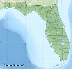
Sarasota Bay, the largest and deepest coastal bay between
149:, with three "passes" or inlets giving access from the
604:
553:
472:
361:
109:
104:
90:
80:
72:
67:
21:
341:
8:
690:Bodies of water of Sarasota County, Florida
202:, that separate the body of water from the
685:Bodies of water of Manatee County, Florida
348:
334:
326:
36:to St. Armand Circle, across Sarasota Bay
145:counties, it is generally treated as an
16:Lagoon located in Florida, United States
311:Sarasota Bay page, Sarasota Water Atlas
261:
125:located off the central west coast of
18:
680:Bays of Florida on the Gulf of Mexico
252:eat sea grass, in shallow bay water.
7:
288:"Kayak Coasting, SRQ Magazine(2015)"
54:
191:an estuary of national significance
14:
53:
46:
27:
137:limited to 150 square miles in
1:
716:
700:Outstanding Florida Waters
206:and the Florida mainland.
356:Coastal waters of Florida
41:
26:
194:. The bay lies between
627:List of Florida rivers
238:
169:
34:John Ringling Causeway
656:27.40222°N 82.59806°W
622:Intracoastal Waterway
233:
163:
661:27.40222; -82.59806
652: /
105:Basin features
617:Florida Everglades
239:
170:
695:Sarasota, Florida
635:
634:
166:Siesta Key Bridge
116:
115:
110:Protection status
707:
667:
666:
664:
663:
662:
657:
653:
650:
649:
648:
645:
540:South Lake Worth
480:Baker's Haulover
350:
343:
336:
327:
298:
297:
295:
294:
284:
278:
275:
269:
266:
186:Charlotte Harbor
57:
56:
50:
31:
19:
715:
714:
710:
709:
708:
706:
705:
704:
670:
669:
660:
658:
654:
651:
646:
643:
641:
639:
638:
636:
631:
600:
596:Mosquito Lagoon
549:
500:Gasparilla Pass
468:
357:
354:
307:
302:
301:
292:
290:
286:
285:
281:
276:
272:
267:
263:
258:
228:
196:barrier islands
63:
62:
61:
60:
59:
58:
37:
17:
12:
11:
5:
713:
711:
703:
702:
697:
692:
687:
682:
672:
671:
633:
632:
630:
629:
624:
619:
614:
612:Big Bend Coast
608:
606:
602:
601:
599:
598:
593:
591:Matanzas River
588:
586:Marquesas Keys
583:
578:
573:
568:
563:
557:
555:
551:
550:
548:
547:
542:
537:
532:
527:
522:
520:Pensacola Pass
517:
512:
507:
502:
497:
492:
487:
482:
476:
474:
470:
469:
467:
466:
461:
456:
451:
446:
441:
436:
431:
426:
421:
416:
411:
406:
401:
396:
391:
389:Choctawhatchee
386:
381:
376:
371:
365:
363:
359:
358:
355:
353:
352:
345:
338:
330:
324:
323:
318:
313:
306:
305:External links
303:
300:
299:
279:
270:
260:
259:
257:
254:
227:
224:
204:Gulf of Mexico
151:Gulf of Mexico
135:drainage basin
114:
113:
111:
107:
106:
102:
101:
92:
88:
87:
82:
78:
77:
74:
70:
69:
65:
64:
52:
51:
45:
44:
43:
42:
39:
38:
32:
24:
23:
15:
13:
10:
9:
6:
4:
3:
2:
712:
701:
698:
696:
693:
691:
688:
686:
683:
681:
678:
677:
675:
668:
665:
628:
625:
623:
620:
618:
615:
613:
610:
609:
607:
603:
597:
594:
592:
589:
587:
584:
582:
579:
577:
574:
572:
571:Halifax River
569:
567:
564:
562:
559:
558:
556:
552:
546:
543:
541:
538:
536:
533:
531:
528:
526:
525:Ponce de Leon
523:
521:
518:
516:
513:
511:
508:
506:
503:
501:
498:
496:
495:Caxambas Pass
493:
491:
488:
486:
483:
481:
478:
477:
475:
471:
465:
462:
460:
457:
455:
452:
450:
447:
445:
442:
440:
439:Ponce de Leon
437:
435:
432:
430:
427:
425:
422:
420:
417:
415:
412:
410:
407:
405:
402:
400:
397:
395:
392:
390:
387:
385:
382:
380:
377:
375:
372:
370:
367:
366:
364:
360:
351:
346:
344:
339:
337:
332:
331:
328:
322:
319:
317:
314:
312:
309:
308:
304:
289:
283:
280:
274:
271:
265:
262:
255:
253:
251:
247:
243:
237:
232:
225:
223:
221:
217:
213:
209:
205:
201:
197:
193:
192:
187:
183:
178:
175:
167:
162:
158:
156:
152:
148:
144:
140:
136:
132:
131:United States
128:
124:
120:
112:
108:
103:
100:
96:
93:
89:
86:
83:
79:
76:United States
75:
71:
66:
49:
40:
35:
30:
25:
20:
637:
576:Indian River
561:Banana River
530:Redfish Pass
490:Captiva Pass
443:
369:Apalachicola
291:. Retrieved
282:
273:
264:
240:
208:Longboat Key
190:
189:
179:
173:
171:
155:urban runoff
119:Sarasota Bay
118:
117:
22:Sarasota Bay
659: /
566:Guana River
449:St. Andrews
248:breach and
674:Categories
647:82°35′53″W
644:27°24′08″N
581:Lake Worth
510:Lake Worth
485:Blind Pass
464:Whitewater
454:St. Joseph
424:Palma Sola
384:Blackwater
293:2017-04-02
256:References
242:Ecotourism
226:Ecotourism
216:Siesta Key
545:St. Lucie
535:Sebastian
505:Hillsboro
429:Pensacola
220:Casey Key
182:Tampa Bay
605:See also
515:Matanzas
444:Sarasota
414:Matanzas
399:Escambia
379:Biscayne
250:manatees
246:dolphins
236:Lido Key
212:Lido Key
174:Zarazote
143:Sarasota
95:Sarasota
91:Counties
68:Location
554:Lagoons
434:Perdido
409:Florida
198:called
147:estuary
139:Manatee
129:in the
127:Florida
99:Manatee
85:Florida
73:Country
473:Inlets
404:Estero
374:Barnes
218:, and
123:lagoon
459:Tampa
121:is a
81:State
419:Palm
394:East
362:Bays
200:keys
184:and
164:The
141:and
676::
214:,
210:,
157:.
97:,
349:e
342:t
335:v
296:.
Text is available under the Creative Commons Attribution-ShareAlike License. Additional terms may apply.