41:
68:
756:
773:
748:
731:
75:
266:
1682:
861:
The village consists of a number of historic buildings dating from the seventeenth century. In order to help preserve its historic and agricultural characteristics, Saughall Massie was designated a
1386:
1219:
910:
902:
306:
1295:
159:
118:
1379:
290:
688:
850:
998:
1372:
1214:
1395:
1220:
https://www.wirral.gov.uk/sites/default/files/all/planning%20and%20building/built%20conservation/saughall%20massie/Policy%20CH17%20Saughall%20Massie.pdf
622:. A small memorial plaque was unveiled on 21 March 2005 on the bridge across the Arrowe Brook on Saughall Massie Road overlooking the crash site.
441:
241:
350:
820:
449:
314:
67:
926:
976:
842:
278:
862:
681:
283:
606:
in
Lancashire earlier. It flew out to sea and on its return over Hoylake he reported that the plane was on fire. It circled over the
1270:
492:, meaning a place where sallows or willow shrubs grew or "Willow tree nook of land". Over the years the name has been spelt as:
332:
229:
195:
812:
445:
149:
614:
south of the village. Pieces were dug up in 1974 and now reside in the museum of the War Plane Wreck
Investigation Group at
841:
of the
Metropolitan Borough of Wirral, this being Moreton West and Saughall Massie Ward. Saughall Massie is represented on
630:
Saughall Massie is in the northern part of the Wirral
Peninsula, approximately 2.5 km (1.6 mi) south-east of the
40:
1024:
674:
111:
838:
342:
295:
835:
469:
103:
1192:
1002:
966:
595:
568:
337:
582:
once existed nearby. Saughall Massie's windmill was built circa 1580 to grind grain. It was demolished by 1875.
1536:
950:
619:
529:
209:
846:
1656:
1343:
508:(1546). The name de Massie, de Massey or de Mascy has been connected to the Wirral since the time of the
1451:
1416:
942:
930:
571:
in
England and Wales resulted in most of Wirral, including Saughall Massie, transfer from the county of
134:
1317:
555:
was 98 in 1801, 176 in 1851 and 186 in 1901. The parish was abolished in 1933 and divided between the
1661:
1631:
1461:
1406:
533:
141:
1049:
1571:
1531:
1456:
816:
720:
715:
599:
461:
1606:
1546:
1481:
1476:
906:
591:
560:
185:
177:
1636:
1556:
1237:
828:
762:
525:
465:
452:. A small village primarily made up of large fields owned by local farmers, it is bordered by
271:
1646:
1586:
1501:
1359:
946:
885:
876:
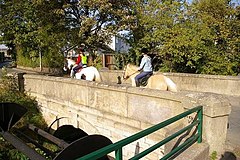
for £200 in 1829. This was the first bridge constructed by notable
Victorian civil engineer
433:
389:
234:
654:. The hamlet is situated at an elevation of around 15 m (49 ft) above sea level.
1252:
881:
615:
513:
509:
46:
1076:
1621:
1149:
1128:
877:
607:
603:
544:
54:
1676:
1566:
1446:
1364:
657:
1466:
914:
909:, is the main thoroughfare through Saughall Massie. The B5192 also connects to the
869:
824:
661:
647:
611:
548:
50:
578:
As with several other agricultural settlements on the Wirral
Peninsula, a timber
1626:
1436:
934:
639:
1651:
1591:
1426:
938:
643:
564:
437:
167:
88:
365:
352:
1616:
1581:
1541:
1431:
1411:
873:
631:
590:
On
January 9, 1944 Lieutenant Jay Frederick Simpson, an American pilot from
579:
517:
219:
1101:
819:
of
Merseyside. The settlement is part of the parliamentary constituency of
1641:
1611:
1601:
1551:
1506:
970:
962:
913:
Upton Bypass bordering to the east, the latter joining
Junction 2 of the
651:
610:
and was seen to lose height and flip over, and crash in a field near the
572:
556:
521:
251:
868:
Saughall Massie Bridge is a single span, single carriageway bridge over
1576:
1521:
1516:
1496:
1491:
1486:
1471:
1421:
792:
787:
740:
540:
453:
201:
1171:
666:
1561:
1511:
782:
128:
551:
in 1866. The population of Saughall Massie and the nearby hamlet of
1526:
1441:
710:
635:
457:
1298:. Trinity Mirror North West & North Wales Limited: Daily Post
1368:
670:
1106:
Liverpool Museums: Historic Characterisation Project (Wirral)
404:
1360:
BBC News: 'Villagers win pub hours campaign' (5 April 2006)
424:
398:
941:
network. Saughall Massie is also a similar distance from
418:
401:
1683:
Towns and villages in the Metropolitan Borough of Wirral
880:
at the beginning of his career. The bridge was awarded
536:
were supposed to have given their name to the village.
516:, whose family came from the settlement of Mascey near
421:
395:
484:
part of the name has been recorded as deriving from
407:
16:
Village on the Wirral Peninsula, Merseyside, England
1079:. Saughall Massie Village Conservation Area Society
1071:
1069:
1067:
415:
412:
392:
305:
289:
277:
265:
250:
240:
228:
218:
208:
194:
176:
158:
140:
126:
110:
98:
26:
1172:"SRTM & Ordnance Survey Elevation Data in PHP"
993:
991:
1001:. Metropolitan Borough of Wirral. Archived from
831:representative, who has been the MP since 1992.
1296:"Village bridge the first by engineering giant"
646:and about 7 km (4.3 mi) west of the
638:, about 4.5 km (2.8 mi) east of the
1380:
1050:"Key to English Place Names: Saughall Massie"
682:
8:
1096:
1094:
532:, settled on the Wirral during the reign of
917:just to the north-east of Saughall Massie.
472:Saughall Massie had a population of 1,260.
1387:
1373:
1365:
905:Saughall Massie Road, which heads west to
689:
675:
667:
23:
1264:
1262:
987:
925:Saughall Massie is equidistant to both
528:in 1150. His relations, the Masseys of
442:Moreton West & Saughall Massie Ward
304:
260:
217:
193:
125:
109:
74:
37:
1247:
1246:
1235:
823:. The current Member of Parliament is
664:to the south-west of Saughall Massie.
448:and the parliamentary constituency of
999:"Wirral 2001 Census: Saughall Massie"
288:
276:
264:
249:
239:
227:
207:
175:
157:
139:
7:
1348:. London: Whittaker & Co. p.206.
1345:The History of the Hundred of Wirral
706:
1342:Mortimer, William Williams (1847).
1215:"Saughall Massie conservation area"
1152:. GENUKI UK & Ireland Genealogy
977:Listed buildings in Saughall Massie
843:Wirral Metropolitan Borough Council
602:. The plane had taken off from the
1396:Populated places in Wirral Borough
1275:National Heritage List for England
1271:"Saughall Massie Bridge (1391581)"
1129:"The Massie Family: Early History"
14:
1294:Murphy, Liam (21 November 2005).
1025:"Coordinate Distance Calculator"
771:
754:
746:
729:
594:was killed whilst test flying a
388:
73:
66:
39:
811:Saughall Massie is part of the
569:local government reorganisation
133:181 mi (291 km)
1102:"Wirral Place Names - Origins"
813:Metropolitan Borough of Wirral
446:Metropolitan Borough of Wirral
1:
849:councillors. The most recent
772:
730:
440:, England. It is part of the
755:
747:
49:Saughall Massie Bridge over
1318:"Plaque unveiled at bridge"
834:The area is also part of a
598:(serial no. 42-75584) over
547:, Saughall Massie became a
539:Formerly a township in the
112:OS grid reference
1699:
1320:. Wirral Globe. 4 May 2007
1193:"Your Councillors by Ward"
1052:. University of Nottingham
853:took place on 6 May 2021.
557:County Borough of Wallasey
1402:
967:Cheshire West and Chester
704:
596:Republic P-47 Thunderbolt
323:
301:
261:
142:Metropolitan borough
61:
38:
31:
1077:"History & Heritage"
933:railway stations on the
160:Metropolitan county
432:) is a village on the
230:Postcode district
1127:Armitstead, Kenrick.
943:Upton railway station
604:US Burtonwood Airbase
1005:on 29 September 2007
872:. It was built from
210:Sovereign state
1108:. wirralhistory.com
965:, a village in the
951:Transport for Wales
817:metropolitan county
698:Neighbouring places
567:. On 1 April 1974,
362: /
53:, built in 1829 by
1269:Historic England,
878:Sir Thomas Brassey
592:Gillett, Wisconsin
366:53.3859°N 3.1333°W
307:UK Parliament
242:Dialling code
55:Sir Thomas Brassey
21:Village in England
1670:
1669:
1245:External link in
1150:"Saughall Massie"
865:in January 1974.
863:conservation area
803:
802:
798:
797:
586:USAAF plane crash
526:Birkenhead Priory
381:
380:
1690:
1647:Wallasey Village
1389:
1382:
1375:
1366:
1349:
1330:
1329:
1327:
1325:
1314:
1308:
1307:
1305:
1303:
1291:
1285:
1284:
1283:
1281:
1266:
1257:
1256:
1250:
1249:
1243:
1241:
1233:
1231:
1229:
1224:. Wirral Council
1223:
1211:
1205:
1204:
1202:
1200:
1195:. Wirral Council
1189:
1183:
1182:
1180:
1178:
1168:
1162:
1161:
1159:
1157:
1146:
1140:
1139:
1137:
1135:
1124:
1118:
1117:
1115:
1113:
1098:
1089:
1088:
1086:
1084:
1073:
1062:
1061:
1059:
1057:
1046:
1040:
1039:
1037:
1035:
1021:
1015:
1014:
1012:
1010:
995:
947:Borderlands Line
886:English Heritage
836:local government
775:
774:
758:
757:
750:
749:
733:
732:
707:
691:
684:
677:
668:
434:Wirral Peninsula
431:
430:
427:
426:
423:
420:
417:
414:
410:
409:
406:
403:
400:
397:
394:
377:
376:
374:
373:
372:
371:53.3859; -3.1333
367:
363:
360:
359:
358:
355:
329:
204:
122:
121:
87:Location within
77:
76:
70:
43:
34:
24:
1698:
1697:
1693:
1692:
1691:
1689:
1688:
1687:
1673:
1672:
1671:
1666:
1597:Saughall Massie
1398:
1393:
1356:
1341:
1338:
1333:
1323:
1321:
1316:
1315:
1311:
1301:
1299:
1293:
1292:
1288:
1279:
1277:
1268:
1267:
1260:
1244:
1234:
1227:
1225:
1217:
1213:
1212:
1208:
1198:
1196:
1191:
1190:
1186:
1176:
1174:
1170:
1169:
1165:
1155:
1153:
1148:
1147:
1143:
1133:
1131:
1126:
1125:
1121:
1111:
1109:
1100:
1099:
1092:
1082:
1080:
1075:
1074:
1065:
1055:
1053:
1048:
1047:
1043:
1033:
1031:
1023:
1022:
1018:
1008:
1006:
997:
996:
989:
985:
959:
923:
899:
894:
882:Grade II listed
859:
851:local elections
809:
804:
799:
759:
752:Saughall Massie
700:
695:
660:converges with
628:
616:Fort Perch Rock
588:
575:to Merseyside.
514:Hamon de Mascey
510:Norman Conquest
478:
411:
391:
387:
384:Saughall Massie
370:
368:
364:
361:
356:
353:
351:
349:
348:
347:
327:
319:
200:
190:
172:
154:
117:
116:
94:
93:
92:
91:
85:
84:
83:
82:
81:Saughall Massie
78:
57:
47:Grade II listed
32:
27:Saughall Massie
22:
17:
12:
11:
5:
1696:
1694:
1686:
1685:
1675:
1674:
1668:
1667:
1665:
1664:
1659:
1654:
1649:
1644:
1639:
1634:
1629:
1624:
1622:Thornton Hough
1619:
1614:
1609:
1604:
1599:
1594:
1589:
1584:
1579:
1574:
1569:
1564:
1559:
1554:
1549:
1544:
1539:
1534:
1529:
1524:
1519:
1514:
1509:
1504:
1499:
1494:
1489:
1484:
1479:
1474:
1469:
1464:
1459:
1454:
1449:
1444:
1439:
1434:
1429:
1424:
1419:
1414:
1409:
1403:
1400:
1399:
1394:
1392:
1391:
1384:
1377:
1369:
1363:
1362:
1355:
1354:External links
1352:
1351:
1350:
1337:
1334:
1332:
1331:
1309:
1286:
1258:
1206:
1184:
1163:
1141:
1119:
1090:
1063:
1041:
1016:
986:
984:
981:
980:
979:
974:
958:
955:
949:, operated by
922:
919:
898:
895:
893:
890:
858:
855:
808:
805:
801:
800:
796:
795:
790:
785:
779:
778:
776:
769:
766:
765:
760:
745:
743:
737:
736:
734:
727:
724:
723:
718:
713:
705:
702:
701:
696:
694:
693:
686:
679:
671:
627:
624:
608:RAF West Kirby
587:
584:
545:Wirral Hundred
543:Parish of the
524:, established
477:
474:
379:
378:
346:
345:
340:
335:
330:
328:List of places
324:
321:
320:
318:
317:
311:
309:
303:
302:
299:
298:
293:
287:
286:
281:
275:
274:
269:
263:
262:
259:
258:
255:
248:
247:
244:
238:
237:
232:
226:
225:
222:
216:
215:
214:United Kingdom
212:
206:
205:
198:
192:
191:
189:
188:
182:
180:
174:
173:
171:
170:
164:
162:
156:
155:
153:
152:
146:
144:
138:
137:
131:
124:
123:
114:
108:
107:
100:
96:
95:
86:
80:
79:
72:
71:
65:
64:
63:
62:
59:
58:
44:
36:
35:
29:
28:
20:
15:
13:
10:
9:
6:
4:
3:
2:
1695:
1684:
1681:
1680:
1678:
1663:
1660:
1658:
1655:
1653:
1650:
1648:
1645:
1643:
1640:
1638:
1635:
1633:
1630:
1628:
1625:
1623:
1620:
1618:
1615:
1613:
1610:
1608:
1605:
1603:
1600:
1598:
1595:
1593:
1590:
1588:
1585:
1583:
1580:
1578:
1575:
1573:
1570:
1568:
1567:Port Sunlight
1565:
1563:
1560:
1558:
1555:
1553:
1550:
1548:
1545:
1543:
1540:
1538:
1535:
1533:
1530:
1528:
1525:
1523:
1520:
1518:
1515:
1513:
1510:
1508:
1505:
1503:
1500:
1498:
1495:
1493:
1490:
1488:
1485:
1483:
1480:
1478:
1475:
1473:
1470:
1468:
1465:
1463:
1460:
1458:
1455:
1453:
1450:
1448:
1447:Clatterbridge
1445:
1443:
1440:
1438:
1435:
1433:
1430:
1428:
1425:
1423:
1420:
1418:
1415:
1413:
1410:
1408:
1405:
1404:
1401:
1397:
1390:
1385:
1383:
1378:
1376:
1371:
1370:
1367:
1361:
1358:
1357:
1353:
1347:
1346:
1340:
1339:
1335:
1319:
1313:
1310:
1297:
1290:
1287:
1276:
1272:
1265:
1263:
1259:
1254:
1248:|format=
1239:
1221:
1216:
1210:
1207:
1194:
1188:
1185:
1173:
1167:
1164:
1151:
1145:
1142:
1130:
1123:
1120:
1107:
1103:
1097:
1095:
1091:
1078:
1072:
1070:
1068:
1064:
1051:
1045:
1042:
1030:
1026:
1020:
1017:
1004:
1000:
994:
992:
988:
982:
978:
975:
972:
968:
964:
961:
960:
956:
954:
952:
948:
944:
940:
936:
932:
928:
920:
918:
916:
912:
908:
904:
896:
891:
889:
887:
883:
879:
875:
871:
866:
864:
856:
854:
852:
848:
844:
840:
837:
832:
830:
826:
822:
818:
814:
806:
794:
791:
789:
786:
784:
781:
780:
777:
770:
768:
767:
764:
761:
753:
744:
742:
739:
738:
735:
728:
726:
725:
722:
719:
717:
714:
712:
709:
708:
703:
699:
692:
687:
685:
680:
678:
673:
672:
669:
665:
663:
659:
658:Greasby Brook
655:
653:
649:
645:
641:
637:
633:
625:
623:
621:
617:
613:
609:
605:
601:
597:
593:
585:
583:
581:
576:
574:
570:
566:
562:
558:
554:
550:
546:
542:
537:
535:
531:
527:
523:
519:
515:
511:
507:
503:
499:
495:
491:
487:
483:
475:
473:
471:
467:
463:
459:
455:
451:
447:
443:
439:
435:
429:
385:
375:
344:
341:
339:
336:
334:
331:
326:
325:
322:
316:
313:
312:
310:
308:
300:
297:
294:
292:
285:
282:
280:
273:
270:
268:
256:
253:
252:ISO 3166
245:
243:
236:
233:
231:
223:
221:
213:
211:
203:
199:
197:
187:
184:
183:
181:
179:
169:
166:
165:
163:
161:
151:
148:
147:
145:
143:
136:
132:
130:
120:
115:
113:
105:
101:
97:
90:
69:
60:
56:
52:
48:
42:
30:
25:
19:
1596:
1537:New Brighton
1344:
1336:Bibliography
1322:. Retrieved
1312:
1300:. Retrieved
1289:
1278:, retrieved
1274:
1226:. Retrieved
1209:
1197:. Retrieved
1187:
1175:. Retrieved
1166:
1154:. Retrieved
1144:
1132:. Retrieved
1122:
1110:. Retrieved
1105:
1081:. Retrieved
1054:. Retrieved
1044:
1032:. Retrieved
1028:
1019:
1007:. Retrieved
1003:the original
924:
915:M53 motorway
900:
870:Arrowe Brook
867:
860:
847:Conservative
833:
825:Angela Eagle
810:
751:
697:
662:Arrowe Brook
656:
648:River Mersey
629:
620:New Brighton
612:Arrowe Brook
589:
577:
552:
549:civil parish
538:
505:
501:
497:
493:
489:
485:
481:
479:
383:
382:
102:1,260 (
51:Arrowe Brook
18:
1627:Thurstaston
1437:Bromborough
1029:boulter.com
935:Wirral Line
640:Dee Estuary
553:Carr Houses
470:2001 census
369: /
104:2001 Census
1657:Woodchurch
1652:West Kirby
1592:Rock Ferry
1427:Birkenhead
1302:30 January
1177:1 November
983:References
939:Merseyrail
884:status by
807:Governance
644:West Kirby
565:West Kirby
506:Saughoughe
438:Merseyside
354:53°23′09″N
343:Merseyside
296:North West
284:Merseyside
272:Merseyside
254: code
186:North West
168:Merseyside
99:Population
89:Merseyside
1617:Thingwall
1582:Raby Mere
1542:New Ferry
1452:Claughton
1432:Brimstage
1417:Beechwood
1412:Bebington
892:Transport
888:in 2006.
874:sandstone
857:Landmarks
845:by three
815:, in the
632:Irish Sea
626:Geography
534:King John
518:Avranches
468:. At the
357:3°08′00″W
291:Ambulance
220:Post town
1677:Category
1662:Woodside
1642:Wallasey
1632:Tranmere
1612:Storeton
1602:Seacombe
1552:Noctorum
1507:Landican
1462:Egremont
1407:Barnston
1280:4 August
1238:cite web
1228:4 August
1156:1 August
1112:4 August
1083:4 August
1056:4 August
971:Cheshire
969:area of
963:Saughall
957:See also
821:Wallasey
652:Seacombe
580:peg mill
573:Cheshire
522:Normandy
512:. Baron
504:(1385);
500:(1309);
498:Salghale
496:(1249);
482:Saughall
450:Wallasey
315:Wallasey
119:SJ247882
1577:Prenton
1572:Poulton
1532:Moreton
1522:Liscard
1517:Leasowe
1497:Hoylake
1492:Heswall
1487:Greasby
1472:Frankby
1457:Eastham
1422:Bidston
1034:6 March
945:on the
937:of the
927:Moreton
793:Greasby
788:Greasby
741:Hoylake
721:Moreton
716:Moreton
600:Moreton
563:, near
541:Bidston
502:Salgham
476:History
462:Moreton
454:Greasby
444:of the
338:England
202:England
196:Country
127:•
33:Village
1607:Spital
1562:Pensby
1547:Newton
1512:Larton
1482:Grange
1477:Gayton
1324:17 May
1199:22 May
1134:17 May
1009:9 July
907:Grange
829:Labour
783:Larton
561:Grange
494:Saligh
267:Police
257:GB-WRL
224:WIRRAL
178:Region
150:Wirral
129:London
1637:Upton
1557:Oxton
1527:Meols
1442:Caldy
931:Meols
911:A5027
903:B5192
763:Upton
711:Meols
636:Meols
466:Upton
458:Meols
1587:Raby
1502:Irby
1467:Ford
1326:2007
1304:2009
1282:2020
1253:help
1230:2020
1201:2014
1179:2016
1158:2020
1136:2007
1114:2020
1085:2020
1058:2020
1036:2016
1011:2010
929:and
921:Rail
901:The
897:Road
839:ward
827:, a
559:and
530:Sale
490:halh
488:and
486:salh
480:The
464:and
279:Fire
246:0151
235:CH49
45:The
650:at
642:at
634:at
1679::
1273:,
1261:^
1242::
1240:}}
1236:{{
1104:.
1093:^
1066:^
1027:.
990:^
953:.
618:,
520:,
460:,
456:,
436:,
405:ɔː
333:UK
135:SE
1388:e
1381:t
1374:v
1328:.
1306:.
1255:)
1251:(
1232:.
1222:)
1218:(
1203:.
1181:.
1160:.
1138:.
1116:.
1087:.
1060:.
1038:.
1013:.
973:.
690:e
683:t
676:v
428:/
425:i
422:s
419:æ
416:m
413:ˈ
408:l
402:ɡ
399:ɒ
396:s
393:ˈ
390:/
386:(
106:)
Text is available under the Creative Commons Attribution-ShareAlike License. Additional terms may apply.