29:
41:
535:
The delta of the Save River includes mangrove forests which span approximately 100 km (62 mi) on the Indian Ocean coast. Villagers in the delta basin use the mangrove forests for timber and small-scale fishing. The ecology of the lower Save River basin has been affected by cyclones,
566:
641:
Massuanganhe, Elídio A.; Macamo, Celia; Westerberg, Lars-Ove; Salomão, Bandeira; Mavume, Alberto; Ribeiro, Eunice (2015). "Deltaic coasts under climate-related catastrophic events – Insights from the Save River delta, Mozambique".
424:. It then turns south, drops over the Chivirira (“Place of Boiling”) Falls, and flows down the western side of Zimbabwe's Eastern Highlands, forming a dry river valley in the rain shadow of these mountains. It is joined by the
435:
The Save River provided irrigation for sugar plantation, but now supports the cultivation of citrus, cotton, rice, and wheat. It is also a source of small-scale fishing for the local population.
462:
era, the administrative units of the area south of the Save changed over time, but the longer lasting were the districts of Gaza and
Inhambane; presently, the Save separates the provinces of
949:
687:
1186:
1176:
1196:
1191:
186:
1181:
942:
610:
543:
Historically it was a transport route for gold and trade goods between the coast and the hinterland occupied by the civilisation of
680:
1122:
523:; the terrestrial ecosystems show less variation along the coastal plain north and south of the river, but inland where the
1166:
935:
111:
428:
or Lundi at the
Mozambique border, forming a dramatic confluence at Mahenya. It then crosses Mozambique to flow into the
1171:
970:
958:
1161:
673:
708:
696:
978:
274:(Period: 1979–2015) 13.8 km/a (440 m/s) (Period: 1971–2000)438 m/s (15,500 cu ft/s)
841:
836:
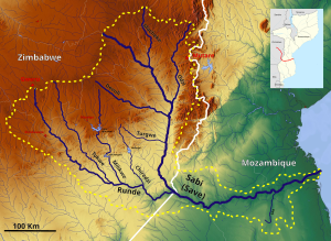
524:
439:
401:
1083:
1053:
651:
1063:
911:
826:
821:
806:
781:
776:
746:
736:
471:
420:, then flows south and then east, from the Zimbabwean highveld to its confluence with the
1043:
1018:
1008:
988:
881:
846:
721:
544:
537:
528:
501:
345:
28:
1155:
1068:
1048:
1038:
1013:
1003:
998:
896:
871:
851:
811:
796:
791:
786:
766:
756:
751:
463:
655:
239:
106,420 km (41,090 sq mi) to 116,100 km (44,800 sq mi)
1088:
1078:
1073:
1058:
1033:
1028:
1023:
993:
983:
891:
886:
876:
856:
771:
761:
741:
508:
493:
429:
261:
172:
567:
SADC - Shared
Watercourses Support Project for Buzi, Save and Ruvuma River Basins
1103:
1098:
906:
901:
861:
831:
816:
731:
726:
716:
520:
425:
383:
157:
485:, while the region immediately to the north is, in general, more supportive of
408:) is a 640 km (400 mi) river of southeastern Africa, flowing through
962:
421:
416:. The river has its source in Zimbabwe, some 80 km (50 mi) south of
413:
370:
63:
1137:
1124:
624:
201:
188:
126:
113:
531:
develops, which is completely different from the forests found in the south.
516:
467:
447:
40:
700:
512:
497:
481:
Politically, the “south-of-the-Save” can be considered the stronghold of
443:
409:
300:
Vila France do Save (Basin size: 100,885 km (38,952 sq mi)
97:
59:
1108:
927:
916:
801:
482:
451:
665:
500:(or Xi-Tsonga), to the south, from those that speak languages of the
486:
475:
459:
417:
93:
579:"GEF TWAP - Transboundary Waters Assessment Programme — GEF TWAP"
592:
931:
669:
611:
310:(Period: 1976–1979)503 m/s (17,800 cu ft/s)
231:
640 km (400 mi) to 740 km (460 mi)
578:
969:
707:
376:
363:
355:
343:
338:
324:
314:
304:
294:
286:
268:
255:
247:
235:
227:
217:
178:
166:
156:
142:
103:
86:
78:
69:
55:
50:
21:
943:
681:
511:, its mouth corresponds to the separation of
8:
950:
936:
928:
688:
674:
666:
330:3,022 m/s (106,700 cu ft/s)
507:Ecologically, as the Save flows into the
556:
606:
604:
602:
562:
560:
18:
7:
320:6.4 m/s (230 cu ft/s)
636:
634:
632:
620:
618:
547:in the 13th and 14th centuries AD.
14:
39:
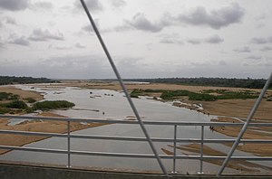
33:A view of the Save in Mozambique
27:
1187:Geography of Inhambane Province
656:10.1016/j.ocecoaman.2015.08.008
1177:International rivers of Africa
644:Ocean & Coastal Management
180: • coordinates
105: • coordinates
1:
496:that are native speakers of
70:Physical characteristics
16:River in Zimbabwe, Mozambique
1197:Geography of Sofala Province
1192:Geography of Manica Province
470:to the south, from those of
219: • elevation
148:1,470 m (4,820 ft)
144: • elevation
296: • location
257: • location
168: • location
88: • location
1213:
1182:Geography of Gaza Province
326: • maximum
316: • minimum
306: • average
270: • average
519:, to the north, from the
334:
282:
278:
243:
202:20.9041694°S 35.0627528°E
152:
74:
38:
26:
378: • right
1138:20.904169°S 35.062752°E
536:flooding, erosion, and
492:The Save separates the
365: • left
207:-20.9041694; 35.0627528
438:It divides Mozambique
1143:-20.904169; 35.062752
650:. Elsevier: 331–340.
525:Chimanimani Mountains
127:18.65000°S 31.12083°E
1167:Rivers of Mozambique
223:0 m (0 ft)
45:The Save River basin
1172:Save River (Africa)
1134: /
504:group in the north;
339:Basin features
198: /
132:-18.65000; 31.12083
123: /
1162:Rivers of Zimbabwe
1117:
1116:
925:
924:
390:
389:
1204:
1149:
1148:
1146:
1145:
1144:
1139:
1135:
1132:
1131:
1130:
1127:
952:
945:
938:
929:
842:Ngezi (Midlands)
837:Ngezi (Masvingo)
690:
683:
676:
667:
660:
659:
638:
627:
622:
613:
608:
597:
596:
593:"Rivers Network"
589:
583:
582:
575:
569:
564:
440:administratively
382:Devuli, Turgwe,
379:
366:
348:
327:
317:
307:
297:
271:
258:
213:
212:
210:
209:
208:
203:
199:
196:
195:
194:
191:
145:
138:
137:
135:
134:
133:
128:
124:
121:
120:
119:
116:
106:
89:
43:
31:
19:
1212:
1211:
1207:
1206:
1205:
1203:
1202:
1201:
1152:
1151:
1142:
1140:
1136:
1133:
1128:
1125:
1123:
1121:
1120:
1118:
1113:
965:
956:
926:
921:
703:
694:
664:
663:
640:
639:
630:
623:
616:
609:
600:
591:
590:
586:
577:
576:
572:
565:
558:
553:
432:at about 21°S.
377:
364:
344:
325:
315:
305:
295:
269:
256:
220:
206:
204:
200:
197:
192:
189:
187:
185:
184:
181:
169:
143:
131:
129:
125:
122:
117:
114:
112:
110:
109:
104:
87:
46:
34:
17:
12:
11:
5:
1210:
1208:
1200:
1199:
1194:
1189:
1184:
1179:
1174:
1169:
1164:
1154:
1153:
1115:
1114:
1112:
1111:
1106:
1101:
1096:
1091:
1086:
1081:
1076:
1071:
1066:
1061:
1056:
1051:
1046:
1041:
1036:
1031:
1026:
1021:
1016:
1011:
1006:
1001:
996:
991:
986:
981:
975:
973:
967:
966:
957:
955:
954:
947:
940:
932:
923:
922:
920:
919:
914:
909:
904:
899:
894:
889:
884:
879:
874:
869:
864:
859:
854:
849:
844:
839:
834:
829:
824:
819:
814:
809:
804:
799:
794:
789:
784:
779:
774:
769:
764:
759:
754:
749:
744:
739:
734:
729:
724:
719:
713:
711:
705:
704:
695:
693:
692:
685:
678:
670:
662:
661:
628:
614:
598:
584:
570:
555:
554:
552:
549:
545:Great Zimbabwe
538:sea level rise
533:
532:
529:montane forest
505:
490:
479:
388:
387:
380:
374:
373:
367:
361:
360:
357:
353:
352:
349:
341:
340:
336:
335:
332:
331:
328:
322:
321:
318:
312:
311:
308:
302:
301:
298:
292:
291:
288:
284:
283:
280:
279:
276:
275:
272:
266:
265:
259:
253:
252:
249:
245:
244:
241:
240:
237:
233:
232:
229:
225:
224:
221:
218:
215:
214:
182:
179:
176:
175:
170:
167:
164:
163:
160:
154:
153:
150:
149:
146:
140:
139:
107:
101:
100:
90:
84:
83:
80:
76:
75:
72:
71:
67:
66:
57:
53:
52:
48:
47:
44:
36:
35:
32:
24:
23:
15:
13:
10:
9:
6:
4:
3:
2:
1209:
1198:
1195:
1193:
1190:
1188:
1185:
1183:
1180:
1178:
1175:
1173:
1170:
1168:
1165:
1163:
1160:
1159:
1157:
1150:
1147:
1110:
1107:
1105:
1102:
1100:
1097:
1095:
1092:
1090:
1087:
1085:
1082:
1080:
1077:
1075:
1072:
1070:
1067:
1065:
1062:
1060:
1057:
1055:
1052:
1050:
1047:
1045:
1042:
1040:
1037:
1035:
1032:
1030:
1027:
1025:
1022:
1020:
1017:
1015:
1012:
1010:
1007:
1005:
1002:
1000:
997:
995:
992:
990:
987:
985:
982:
980:
977:
976:
974:
972:
968:
964:
960:
953:
948:
946:
941:
939:
934:
933:
930:
918:
915:
913:
910:
908:
905:
903:
900:
898:
895:
893:
890:
888:
885:
883:
880:
878:
875:
873:
870:
868:
865:
863:
860:
858:
855:
853:
850:
848:
845:
843:
840:
838:
835:
833:
830:
828:
825:
823:
820:
818:
815:
813:
810:
808:
805:
803:
800:
798:
795:
793:
790:
788:
785:
783:
780:
778:
775:
773:
770:
768:
765:
763:
760:
758:
755:
753:
750:
748:
745:
743:
740:
738:
735:
733:
730:
728:
725:
723:
720:
718:
715:
714:
712:
710:
706:
702:
698:
691:
686:
684:
679:
677:
672:
671:
668:
657:
653:
649:
645:
637:
635:
633:
629:
626:
621:
619:
615:
612:
607:
605:
603:
599:
594:
588:
585:
580:
574:
571:
568:
563:
561:
557:
550:
548:
546:
541:
539:
530:
526:
522:
518:
514:
510:
506:
503:
499:
495:
494:ethnic groups
491:
488:
484:
480:
478:to the north:
477:
473:
469:
465:
461:
457:
456:
455:
453:
449:
445:
441:
436:
433:
431:
427:
423:
419:
415:
411:
407:
403:
399:
395:
385:
381:
375:
372:
368:
362:
358:
354:
350:
347:
342:
337:
333:
329:
323:
319:
313:
309:
303:
299:
293:
289:
285:
281:
277:
273:
267:
263:
260:
254:
250:
246:
242:
238:
234:
230:
226:
222:
216:
211:
190:20°54′15.01″S
183:
177:
174:
171:
165:
161:
159:
155:
151:
147:
141:
136:
108:
102:
99:
95:
91:
85:
81:
77:
73:
68:
65:
61:
58:
54:
49:
42:
37:
30:
25:
20:
1119:
1093:
866:
647:
643:
587:
573:
542:
534:
509:Indian Ocean
452:ecologically
437:
434:
430:Indian Ocean
405:
397:
393:
391:
346:River system
264:(near mouth)
262:Indian Ocean
193:35°3′45.91″E
173:Indian Ocean
1141: /
521:subtropical
458:During the
444:politically
426:Runde River
356:Tributaries
205: /
130: /
1156:Categories
1129:35°03′46″E
1126:20°54′15″S
963:Mozambique
822:Mtetengwe
625:Sabi River
551:References
517:ecosystems
448:ethnically
422:Odzi River
414:Mozambique
402:Portuguese
398:Sabi River
394:Save River
351:Save River
236:Basin size
64:Mozambique
22:Save River
1064:Montepuez
912:Umchabezi
827:Mzingwane
807:Mutirikwe
782:Mtshelele
777:Mtshabezi
747:Inyankuni
737:Inkankezi
527:start, a
468:Inhambane
369:Macheke,
287:Discharge
248:Discharge
118:31°7′15″E
115:18°39′0″S
92:South of
1054:Mocubúri
1044:Megaruma
1009:Luambala
989:Infulene
882:Shangani
847:Ngondoma
722:Chiredzi
701:Zimbabwe
513:tropical
498:Shangaan
460:colonial
410:Zimbabwe
406:Rio Save
98:Zimbabwe
60:Zimbabwe
51:Location
1109:Zambezi
1084:Revúboé
1069:Ngalamu
1049:Messalo
1039:Mbuluzi
1014:Lugenda
1004:Limpopo
999:Licungo
917:Zambezi
897:Tokwane
872:Sebakwe
852:Panhane
812:Mwenezi
802:Mushawe
797:Mupfure
792:Munyati
787:Mucheke
767:Manyame
757:Limpopo
752:Kwe Kwe
515:marine
483:Frelimo
56:Country
1089:Ruvuma
1079:Rarico
1074:Pungwe
1059:Monapo
1034:Mazowe
1029:Matola
1024:Maputo
994:Komati
984:Chinde
971:Rivers
959:Rivers
892:Siwaze
887:Shashe
877:Sengwa
857:Pungwe
772:Mazowe
762:Luenha
742:Insiza
709:Rivers
697:Rivers
487:Renamo
476:Sofala
472:Manica
418:Harare
359:
290:
251:
228:Length
162:
94:Harare
82:
79:Source
1104:Tembe
1099:Shire
1019:Lúrio
907:Thuli
902:Tokwe
862:Runde
832:Ncema
817:Mwewe
732:Honde
727:Gwayi
717:Bubye
502:Shona
396:, or
386:, Coe
384:Runde
158:Mouth
1094:Save
979:Buzi
867:Save
474:and
466:and
464:Gaza
450:and
412:and
392:The
371:Odzi
961:of
699:of
652:doi
648:116
1158::
646:.
631:^
617:^
601:^
559:^
540:.
454::
446:,
442:,
404::
96:,
62:,
951:e
944:t
937:v
689:e
682:t
675:v
658:.
654::
595:.
581:.
489:;
400:(
Text is available under the Creative Commons Attribution-ShareAlike License. Additional terms may apply.