38:
304:
213:. The bridge was named after Bob Scarborough, a housing developer who established the Barclay Farm neighborhood, where the bridge is located. A bridge was needed in the area to extend the subdivision street system over the North Branch, which is a small
341:
705:
586:
611:
246:
314:
273:
715:
720:
334:
52:
725:
487:
700:
710:
504:
327:
499:
575:
308:
570:
482:
477:
444:
439:
409:
394:
374:
45:
622:
494:
399:
591:
520:
472:
379:
555:
218:
97:
250:
17:
350:
198:
108:
419:
414:
384:
525:
424:
404:
389:
277:
565:
369:
364:
191:
545:
616:
581:
678:
628:
606:
550:
136:
560:
225:
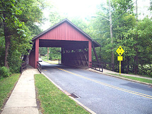
and was open to traffic on
February 14, 1959. The bridge was renovated in 1993. Having a
187:
229:
design, the
Scarborough Bridge is considered a historical landmark for the community.
694:
222:
154:
37:
660:
642:
635:
194:
596:
315:
Throwback
Thursday: Scarborough Covered Bridge stands out in Cherry Hill history
226:
206:
67:
54:
214:
210:
319:
303:
202:
16:
This article is about
Scarborough Bridge. Not to be confused with
184:
323:
201:. It carries 2 lanes of Covered Bridge Road, as well as 2
247:"Scarborough Covered Bridge Celebrates 50th Anniversary"
670:
652:
538:
513:
463:
456:
433:
357:
168:
160:
150:
145:
135:
127:
119:
114:
104:
91:
83:
44:
28:
335:
8:
460:
430:
342:
328:
320:
276:. faculty.lebow.drexel.edu. Archived from
25:
526:Camden County College Cherry Hill Campus
238:
7:
706:Bridges in Camden County, New Jersey
488:Cherry Hill Alternative High School
249:. Cherryhill-nj.com. Archived from
14:
23:Bridge in Cherry Hill, New Jersey
505:Politz Day School of Cherry Hill
302:
36:
87:2 lanes of Covered Bridge Road
1:
716:Covered bridges in New Jersey
576:Garden State Discovery Museum
221:. The bridge was designed by
721:Wooden bridges in New Jersey
587:Katz Jewish Community Center
483:Cherry Hill High School West
478:Cherry Hill High School East
623:Garden State Park Racetrack
500:The King's Christian School
495:Camden Catholic High School
742:
726:Road bridges in New Jersey
592:Merchantville Country Club
521:Cherry Hill Public Library
473:Cherry Hill Public Schools
15:
701:Bridges completed in 1959
571:Congregation M'kor Shalom
173:
35:
464:Primary & secondary
18:Scarborough Bridge, York
711:Cherry Hill, New Jersey
556:Cherry Hill NJT station
351:Cherry Hill, New Jersey
199:Cherry Hill, New Jersey
109:Cherry Hill, New Jersey
68:39.900667°N 74.992547°W
272:Dr. Roger A. McCain.
73:39.900667; -74.992547
566:Congregation Kol Ami
311:at Wikimedia Commons
274:"Scarborough Bridge"
253:on December 29, 2008
96:North Branch of the
64: /
612:Temple Beth Sholom
602:Scarborough Bridge
546:Barclay Farm House
309:Scarborough Bridge
181:Scarborough Bridge
30:Scarborough Bridge
688:
687:
617:Cherry Hill Arena
582:Holly Ravine Farm
534:
533:
452:
451:
307:Media related to
280:on April 29, 2011
177:
176:
164:February 14, 1959
141:12 feet, 6 inches
733:
679:Cherry Hill Park
639:
629:Hawaiian Cottage
607:Springdale Farms
551:Cherry Hill Mall
461:
445:Erlton-Ellisburg
440:Barclay-Kingston
431:
410:Kingston Estates
375:Cherry Hill Mall
344:
337:
330:
321:
306:
290:
289:
287:
285:
269:
263:
262:
260:
258:
243:
100:
79:
78:
76:
75:
74:
69:
65:
62:
61:
60:
57:
40:
26:
741:
740:
736:
735:
734:
732:
731:
730:
691:
690:
689:
684:
666:
648:
634:
530:
514:Other education
509:
465:
448:
429:
400:Golden Triangle
353:
348:
299:
294:
293:
283:
281:
271:
270:
266:
256:
254:
245:
244:
240:
235:
137:Clearance above
115:Characteristics
95:
72:
70:
66:
63:
58:
55:
53:
51:
50:
31:
24:
21:
12:
11:
5:
739:
737:
729:
728:
723:
718:
713:
708:
703:
693:
692:
686:
685:
683:
682:
674:
672:
668:
667:
665:
664:
656:
654:
650:
649:
647:
646:
640:
632:
626:
620:
614:
609:
604:
599:
594:
589:
584:
579:
573:
568:
563:
558:
553:
548:
542:
540:
536:
535:
532:
531:
529:
528:
523:
517:
515:
511:
510:
508:
507:
502:
497:
492:
491:
490:
485:
480:
469:
467:
458:
454:
453:
450:
449:
447:
442:
437:
435:
428:
427:
422:
417:
412:
407:
402:
397:
392:
387:
382:
380:Coffins Corner
377:
372:
367:
361:
359:
355:
354:
349:
347:
346:
339:
332:
324:
318:
317:
312:
298:
297:External links
295:
292:
291:
264:
237:
236:
234:
231:
188:covered bridge
175:
174:
171:
170:
166:
165:
162:
158:
157:
152:
148:
147:
143:
142:
139:
133:
132:
129:
125:
124:
121:
117:
116:
112:
111:
106:
102:
101:
93:
89:
88:
85:
81:
80:
48:
42:
41:
33:
32:
29:
22:
13:
10:
9:
6:
4:
3:
2:
738:
727:
724:
722:
719:
717:
714:
712:
709:
707:
704:
702:
699:
698:
696:
680:
676:
675:
673:
669:
663:
662:
658:
657:
655:
651:
644:
641:
637:
633:
630:
627:
624:
621:
618:
615:
613:
610:
608:
605:
603:
600:
598:
595:
593:
590:
588:
585:
583:
580:
577:
574:
572:
569:
567:
564:
562:
559:
557:
554:
552:
549:
547:
544:
543:
541:
537:
527:
524:
522:
519:
518:
516:
512:
506:
503:
501:
498:
496:
493:
489:
486:
484:
481:
479:
476:
475:
474:
471:
470:
468:
462:
459:
455:
446:
443:
441:
438:
436:
432:
426:
423:
421:
418:
416:
413:
411:
408:
406:
403:
401:
398:
396:
393:
391:
388:
386:
383:
381:
378:
376:
373:
371:
368:
366:
363:
362:
360:
358:Neighborhoods
356:
352:
345:
340:
338:
333:
331:
326:
325:
322:
316:
313:
310:
305:
301:
300:
296:
279:
275:
268:
265:
252:
248:
242:
239:
232:
230:
228:
224:
223:Malcolm Wells
220:
216:
212:
208:
204:
200:
196:
193:
189:
186:
182:
172:
167:
163:
159:
156:
155:Malcolm Wells
153:
149:
144:
140:
138:
134:
130:
126:
122:
118:
113:
110:
107:
103:
99:
94:
90:
86:
82:
77:
49:
47:
43:
39:
34:
27:
19:
661:Courier-Post
659:
645:(demolished)
643:Rickshaw Inn
638:(demolished)
636:Latin Casino
631:(demolished)
619:(demolished)
601:
561:Chick's Deli
282:. Retrieved
278:the original
267:
257:December 26,
255:. Retrieved
251:the original
241:
219:Cooper River
195:neighborhood
192:Barclay Farm
180:
178:
120:Total length
98:Cooper River
434:Former CDPs
207:pedestrians
71: /
46:Coordinates
695:Categories
420:Willowdale
415:Springdale
385:Downs Farm
233:References
227:town truss
211:bicyclists
59:74°59′33″W
56:39°54′02″N
625:(defunct)
578:(defunct)
539:Landmarks
457:Education
425:Woodcrest
405:Greentree
390:Ellisburg
215:tributary
203:sidewalks
597:Ponzio's
169:Location
151:Designer
671:Culture
466:schools
370:Barclay
365:Ashland
284:May 17,
217:of the
190:in the
146:History
131:20 feet
123:55 feet
92:Crosses
84:Carries
395:Erlton
185:wooden
161:Opened
105:Locale
653:Media
183:is a
128:Width
286:2011
259:2011
209:and
205:for
179:The
197:of
697::
681:"
677:"
343:e
336:t
329:v
288:.
261:.
20:.
Text is available under the Creative Commons Attribution-ShareAlike License. Additional terms may apply.