159:
261:
54:
240:, are available and a number of excellent images have been painted and photographed from that vantage point. Privately owned tour companies provide guided fishing and rafting trips commencing from the landing, and the immediate area is a popular spot for
331:
220:
use the landing to gain access to the Snake River, and it is one of four locations in Grand Teton
National Park where the river is easily accessed. Wildlife including
326:
302:
18:
75:
236:
are commonly seen in the immediate vicinity of the landing. Above the landing, along the main highway, some of the finest vistas of the
321:
145:
126:
336:
98:
295:
79:
105:
112:
288:
181:
94:
64:
83:
68:
158:
208:. The landing is accessed via a dirt road immediately north of Moose and is impassable in the winter.
119:
272:
205:
201:
315:
197:
193:
189:
260:
237:
177:
163:
53:
233:
33:
20:
229:
225:
213:
268:
241:
209:
185:
162:
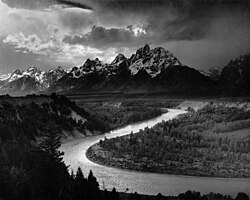
Snake River
Overlook is seen in this classic 1942 photograph taken by
204:, 5 miles (8 km) north of the park's main headquarters at
221:
157:
217:
47:
276:
172:is a boat landing located a few miles south of
296:
192:The boat landing is located off the combined
8:
332:Tourist attractions in Teton County, Wyoming
82:. Unsourced material may be challenged and
303:
289:
146:Learn how and when to remove this message
7:
257:
255:
80:adding citations to reliable sources
327:Geography of Teton County, Wyoming
14:
267:This article about a location in
259:
52:
176:, along the east shore of the
1:
275:. You can help Knowledge by
353:
254:
322:Grand Teton National Park
182:Grand Teton National Park
337:Wyoming geography stubs
166:
95:"Schwabachers Landing"
161:
174:Snake River Overlook
76:improve this article
34:43.7291°N 110.6617°W
170:Schwabacher Landing
30: /
167:
39:43.7291; -110.6617
284:
283:
156:
155:
148:
130:
344:
305:
298:
291:
263:
256:
151:
144:
140:
137:
131:
129:
88:
56:
48:
45:
44:
42:
41:
40:
35:
31:
28:
27:
26:
23:
352:
351:
347:
346:
345:
343:
342:
341:
312:
311:
310:
309:
252:
250:
152:
141:
135:
132:
89:
87:
73:
57:
38:
36:
32:
29:
24:
21:
19:
17:
16:
12:
11:
5:
350:
348:
340:
339:
334:
329:
324:
314:
313:
308:
307:
300:
293:
285:
282:
281:
264:
249:
246:
206:Moose, Wyoming
154:
153:
60:
58:
51:
13:
10:
9:
6:
4:
3:
2:
349:
338:
335:
333:
330:
328:
325:
323:
320:
319:
317:
306:
301:
299:
294:
292:
287:
286:
280:
278:
274:
270:
265:
262:
258:
253:
247:
245:
243:
239:
235:
231:
227:
223:
219:
215:
211:
207:
203:
199:
195:
194:U.S. Route 26
191:
187:
183:
179:
175:
171:
165:
160:
150:
147:
139:
128:
125:
121:
118:
114:
111:
107:
104:
100:
97: –
96:
92:
91:Find sources:
85:
81:
77:
71:
70:
66:
61:This article
59:
55:
50:
49:
46:
43:
277:expanding it
266:
251:
173:
169:
168:
142:
133:
123:
116:
109:
102:
90:
74:Please help
62:
15:
238:Teton Range
234:bald eagles
178:Snake River
164:Ansel Adams
37: /
25:110°39′42″W
316:Categories
248:References
106:newspapers
22:43°43′45″N
244:parties.
230:mule deer
226:pronghorn
214:canoeists
210:Fishermen
63:does not
136:May 2013
269:Wyoming
242:wedding
218:rafters
186:Wyoming
120:scholar
84:removed
69:sources
122:
115:
108:
101:
93:
271:is a
222:moose
127:JSTOR
113:books
273:stub
232:and
216:and
190:U.S.
99:news
67:any
65:cite
202:187
180:in
78:by
318::
228:,
224:,
212:,
198:89
188:,
184:,
304:e
297:t
290:v
279:.
200:/
196:/
149:)
143:(
138:)
134:(
124:·
117:·
110:·
103:·
86:.
72:.
Text is available under the Creative Commons Attribution-ShareAlike License. Additional terms may apply.