31:
47:
54:
254:
96:
30:
190:
The Serranía de
Zapalinamé was designated an ecological conservation area in 1996 by the state government of Coahuila. The protected area covers 253.74 km.
180:
46:
264:
226:
UNEP-WCMC (2021). Protected Area
Profile for Serranía de Zapalinamé from the World Database of Protected Areas. Accessed 12 September 2021.
249:
259:
244:
184:
173:
162:
206:
Encina D., J. A., Encina D., F. J., & Mata R., E. (2011). "Ecología del Bosque de
238:
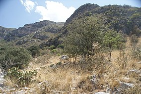
183:. The lower slopes are dry shrublands. The Serranía is in the upper basin of the
111:
98:
176:. The highest peak in the range is El Penitiente at 3,140 meters elevation.
187:, and its forests protect downstream water quality and reduce flood risk.
227:
166:
84:
70:
215:
74:
210:(Betulaceae) de la Sierra de Zapalinamé, Coahuila, México".
212:
Journal of the
Botanical Research Institute of Texas
143:
135:
127:
90:
80:
66:
18:
53:
8:
255:Protected areas of the Sierra Madre Oriental
35:Camino de Cuatro in the Sierra de Zapalinamé
15:
172:The range is a westward extension of the
169:lies immediately north of the mountains.
199:
131:253.74 km (97.97 sq mi)
7:
216:http://www.jstor.org/stable/41972520
165:of northeastern Mexico. The city of
65:
14:
52:
45:
29:
142:
79:
265:Important Bird Areas of Mexico
179:Higher elevations are home to
1:
250:Protected areas of Coahuila
281:
40:
28:
23:
161:is a mountain range and
139:ecological conservation
155:Serranía de Zapalinamé
112:25.33639°N 100.92861°W
19:Serranía de Zapalinamé
260:Sierra Madre Oriental
245:Landforms of Coahuila
174:Sierra Madre Oriental
159:Sierra de Zapalinamé
157:, also known as the
117:25.33639; -100.92861
24:Sierra de Zapalinamé
108: /
214:, 5(1), 305–310.
208:Ostrya virginiana
151:
150:
81:Nearest city
272:
229:
224:
218:
204:
181:pine–oak forests
123:
122:
120:
119:
118:
113:
109:
106:
105:
104:
101:
56:
55:
49:
33:
16:
280:
279:
275:
274:
273:
271:
270:
269:
235:
234:
233:
232:
225:
221:
205:
201:
196:
116:
114:
110:
107:
102:
99:
97:
95:
94:
62:
61:
60:
59:
58:
57:
36:
12:
11:
5:
278:
276:
268:
267:
262:
257:
252:
247:
237:
236:
231:
230:
219:
198:
197:
195:
192:
185:San Juan River
163:protected area
149:
148:
145:
141:
140:
137:
133:
132:
129:
125:
124:
92:
88:
87:
82:
78:
77:
68:
64:
63:
51:
50:
44:
43:
42:
41:
38:
37:
34:
26:
25:
21:
20:
13:
10:
9:
6:
4:
3:
2:
277:
266:
263:
261:
258:
256:
253:
251:
248:
246:
243:
242:
240:
228:
223:
220:
217:
213:
209:
203:
200:
193:
191:
188:
186:
182:
177:
175:
170:
168:
164:
160:
156:
146:
138:
134:
130:
126:
121:
93:
89:
86:
83:
76:
72:
69:
48:
39:
32:
27:
22:
17:
222:
211:
207:
202:
189:
178:
171:
158:
154:
152:
136:Designation
115: /
103:100°55′43″W
91:Coordinates
239:Categories
194:References
144:Designated
100:25°20′11″N
167:Saltillo
85:Saltillo
71:Coahuila
67:Location
75:Mexico
153:The
147:1996
128:Area
241::
73:,
Text is available under the Creative Commons Attribution-ShareAlike License. Additional terms may apply.