44:
315:
51:
668:
634:
406:. Massive mountain, 2,740 metres (8,990 ft) high, standing west of the head of Balham Valley. Named in 1957 by the N.Z. Northern Survey Party of the CTAE (1956-58) as being descriptive of its appearance from almost every direction.
1138:
672:
638:
452:(USARP) oceanographer Jeffrey D. Rude who drowned in McMurdo Sound, October 12, 1975, when the tracked vehicle he was driving broke through bay ice and sank in the vicinity of Erebus Glacier Tongue and Turtle Rock.
1467:
703:
444:. A rock spur 2 nautical miles (3.7 km; 2.3 mi) northwest of Mount Circe that descends from the plateau of Victoria Land toward Balham Lake and Balham Valley. Named by the United States
1100:
1236:
193:
1226:
696:
360:. Snowy peak, about 2,600 metres (8,500 ft) high, rising 3 nautical miles (5.6 km; 3.5 mi) west-southwest of Shapeless Mountain, at the south end of the
86:
1498:
689:
490:. A small lake near the center of Balham Valley in Victoria Land. Named in 1964 by American geologist Parker E. Calkin for its location in Balham Valley.
1399:
449:
135:
642:
365:
201:
1299:
733:
987:
728:
445:
1389:
1329:
982:
43:
1447:
712:
249:
1488:
1246:
676:
1493:
79:
1105:
936:
873:
1339:
1281:
462:
416:
378:
332:
751:
276:
368:(CTAE) (1956-58), because they mistakenly climbed the mountain in the belief they were on Shapeless Mountain.
931:
804:
245:
1291:
1432:
756:
240:
An area of 480 km (190 sq mi), comprising parts of both Balham Valley and the adjacent
1424:
1324:
720:
303:
1251:
1085:
921:
771:
314:
253:
213:
298:
1095:
1206:
1442:
1437:
1369:
1256:
1221:
1183:
293:
322:
Named features include, from west to east, Mistake Peak, Shapeless
Mountain and Balham Lake.
1457:
1404:
1394:
1384:
1344:
1334:
1188:
1158:
1022:
964:
868:
789:
217:
177:
1309:
1168:
1153:
1143:
1065:
1055:
1027:
1012:
888:
878:
837:
784:
779:
761:
743:
649:
225:
256:. It is consequently important as a reference base for measuring changes in the similar
216:. The head of Balham Valley is below Shapeless Mountain. The valley descends between the
1409:
1241:
1148:
1133:
1032:
1017:
992:
946:
916:
908:
845:
827:
794:
241:
229:
681:
1482:
1374:
1349:
1319:
1314:
1304:
1276:
1178:
1173:
1163:
1128:
1110:
974:
956:
926:
898:
883:
863:
822:
817:
361:
221:
181:
1452:
1266:
1261:
1231:
1216:
1211:
1070:
1060:
1007:
1002:
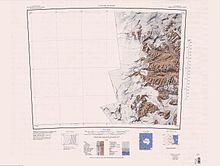
893:
616:
257:
547:
17:
1414:
1379:
1354:
1271:
1198:
1120:
1037:
941:
855:
197:
173:
1462:
1364:
1359:
1080:
1075:
997:
812:
63:
477:
464:
431:
418:
393:
380:
347:
334:
288:
151:
137:
102:
88:
1090:
260:
252:(ASPA)-123 because it is one of the least disturbed or contaminated of the
1047:
555:
Management Plan for
Antarctic Specially Protected Area No. 123: Measure 6
263:
of the other Dry
Valleys where scientific investigations are conducted.
228:
to the south. It flows east-northeast past the Insel Range and joins
313:
685:
204:
who did the first freshwater biology in this area in 1957–58.
364:. So named in 1957 by the N.Z. Northern Survey Party of the
318:
Upper
Victoria Valley towards the north of mapped region
506:
504:
502:
194:
Victoria
University of Wellington Antarctic Expedition
624:(2 ed.), United States Board on Geographic Names
196:(VUWAE: 1958–59) for R.W. Balham, biologist with the
548:"Barwick and Balham Valleys, Southern Victoria Land"
1423:
1290:
1197:
1119:
1046:
973:
955:
907:
854:
836:
803:
770:
742:
719:
78:
73:
32:
534:
697:
8:
704:
690:
682:
29:
450:United States Antarctic Research Program
654:, USGS: United States Geological Survey
643:United States Board on Geographic Names
598:
586:
574:
522:
510:
498:
366:Commonwealth Trans-Antarctic Expedition
202:Commonwealth Trans-Antarctic Expedition
446:Advisory Committee on Antarctic Names
172:) is an ice-free valley] between the
50:
7:
557:. Antarctic Treaty Secretariat. 2008
1499:Antarctic Specially Protected Areas
713:Antarctic Specially Protected Areas
675:from websites or documents of the
641:from websites or documents of the
250:Antarctic Specially Protected Area
236:Antarctic Specially Protected Area
224:to the south. It connects to the
25:
1139:Ablation Point – Ganymede Heights
618:Geographic Names of the Antarctic
671: This article incorporates
666:
637: This article incorporates
632:
49:
42:
677:United States Geological Survey
192:Balham Valley was named by the
615:Alberts, Fred G., ed. (1995),
1:
212:Balham Valley is one of the
304:GPX (secondary coordinates)
1515:
299:GPX (primary coordinates)
274:Map all coordinates using
244:, is protected under the
37:
1489:Valleys of Victoria Land
752:Dakshin Gangotri Glacier
282:Download coordinates as:
1101:North-west White Island
805:Princess Elizabeth Land
246:Antarctic Treaty System
1468:Southern Powell Island
673:public domain material
639:public domain material
319:
1433:Christoffersen Island
757:Svarthamaren Mountain
317:
294:GPX (all coordinates)
1325:Coppermine Peninsula
1237:Eastern Dallmann Bay
932:Géologie Archipelago
721:Queen Elizabeth Land
27:Valley in Antarctica
1494:McMurdo Dry Valleys
1252:Lagotellerie Island
1086:Hut Point Peninsula
922:Bon Docteur Nunatak
772:Mac. Robertson Land
535:Taylor Glacier USGS
474: /
428: /
390: /
344: /
254:McMurdo Dry Valleys
214:McMurdo Dry Valleys
147: /
98: /
1096:New College Valley
478:77.433°S 160.950°E
432:77.450°S 160.817°E
394:77.433°S 160.400°E
372:Shapeless Mountain
348:77.433°S 160.217°E
320:
152:77.417°S 161.017°E
103:77.417°S 161.017°E
18:Shapeless Mountain
1476:
1475:
1443:Fredriksen Island
1438:Coronation Island
1257:Litchfield Island
1222:Bransfield Strait
220:to the north and
127:
126:
16:(Redirected from
1506:
1458:Michelsen Island
1405:Stonethrow Ridge
1400:South East Point
1395:San Telmo Island
1385:Potter Peninsula
1345:Fildes Peninsula
1335:Deception Island
1189:Striation Valley
1159:Ganymede Heights
1023:Linnaeus Terrace
869:Bailey Peninsula
790:Scullin Monolith
706:
699:
692:
683:
670:
669:
661:
660:
659:
636:
635:
631:
630:
629:
623:
602:
596:
590:
584:
578:
572:
566:
565:
563:
562:
552:
544:
538:
532:
526:
520:
514:
508:
489:
488:
486:
485:
484:
483:-77.433; 160.950
479:
475:
472:
471:
470:
467:
448:(US-ACAN) after
443:
442:
440:
439:
438:
437:-77.450; 160.817
433:
429:
426:
425:
424:
421:
405:
404:
402:
401:
400:
399:-77.433; 160.400
395:
391:
388:
387:
386:
383:
359:
358:
356:
355:
354:
353:-77.433; 160.217
349:
345:
342:
341:
340:
337:
218:Apocalypse Peaks
178:Apocalypse Peaks
171:
170:
168:
167:
166:
164:
159:
158:
157:-77.417; 161.017
153:
148:
145:
144:
143:
140:
122:
121:
119:
118:
117:
115:
110:
109:
108:-77.417; 161.017
104:
99:
96:
95:
94:
91:
53:
52:
46:
30:
21:
1514:
1513:
1509:
1508:
1507:
1505:
1504:
1503:
1479:
1478:
1477:
1472:
1419:
1310:Byers Peninsula
1292:South Shetlands
1286:
1207:Apéndice Island
1193:
1169:Marion Nunataks
1154:Flatiron Valley
1144:Ablation Valley
1115:
1066:Beaufort Island
1056:Arrival Heights
1042:
1028:Mount Melbourne
1013:Cape Washington
969:
951:
903:
889:Frazier Islands
879:Clark Peninsula
874:Charlton Island
850:
838:Queen Mary Land
832:
799:
785:Rookery Islands
780:Murray Monolith
766:
762:Yukidori Valley
744:Queen Maud Land
738:
715:
710:
667:
664:
657:
655:
648:
633:
627:
625:
621:
614:
610:
605:
597:
593:
585:
581:
573:
569:
560:
558:
550:
546:
545:
541:
533:
529:
521:
517:
509:
500:
496:
482:
480:
476:
473:
468:
465:
463:
461:
460:
458:
436:
434:
430:
427:
422:
419:
417:
415:
414:
412:
398:
396:
392:
389:
384:
381:
379:
377:
376:
374:
352:
350:
346:
343:
338:
335:
333:
331:
330:
328:
312:
311:
310:
309:
308:
269:
238:
226:McKelvey Valley
210:
190:
162:
160:
156:
154:
150:
149:
146:
141:
138:
136:
134:
133:
113:
111:
107:
105:
101:
100:
97:
92:
89:
87:
85:
84:
69:
68:
67:
66:
61:
60:
59:
58:
54:
28:
23:
22:
15:
12:
11:
5:
1512:
1510:
1502:
1501:
1496:
1491:
1481:
1480:
1474:
1473:
1471:
1470:
1465:
1460:
1455:
1450:
1445:
1440:
1435:
1429:
1427:
1421:
1420:
1418:
1417:
1412:
1410:Suffield Point
1407:
1402:
1397:
1392:
1387:
1382:
1377:
1372:
1370:Narębski Point
1367:
1362:
1357:
1352:
1347:
1342:
1337:
1332:
1327:
1322:
1317:
1312:
1307:
1302:
1296:
1294:
1288:
1287:
1285:
1284:
1279:
1274:
1269:
1264:
1259:
1254:
1249:
1244:
1242:Emperor Island
1239:
1234:
1229:
1224:
1219:
1214:
1209:
1203:
1201:
1195:
1194:
1192:
1191:
1186:
1184:Moutonnée Lake
1181:
1176:
1171:
1166:
1161:
1156:
1151:
1149:Erratic Valley
1146:
1141:
1136:
1134:Ablation Point
1131:
1125:
1123:
1117:
1116:
1114:
1113:
1108:
1106:Sabrina Island
1103:
1098:
1093:
1088:
1083:
1078:
1073:
1068:
1063:
1058:
1052:
1050:
1044:
1043:
1041:
1040:
1035:
1033:Mount Rittmann
1030:
1025:
1020:
1018:Edmonson Point
1015:
1010:
1005:
1000:
995:
993:Canada Glacier
990:
988:Barwick Valley
985:
979:
977:
971:
970:
968:
967:
961:
959:
953:
952:
950:
949:
947:Rostand Island
944:
939:
937:Lamarck Island
934:
929:
924:
919:
917:Bernard Island
913:
911:
905:
904:
902:
901:
896:
891:
886:
881:
876:
871:
866:
860:
858:
852:
851:
849:
848:
846:Haswell Island
842:
840:
834:
833:
831:
830:
828:Mule Peninsula
825:
820:
815:
809:
807:
801:
800:
798:
797:
795:Taylor Rookery
792:
787:
782:
776:
774:
768:
767:
765:
764:
759:
754:
748:
746:
740:
739:
737:
736:
731:
725:
723:
717:
716:
711:
709:
708:
701:
694:
686:
663:
662:
651:Taylor Glacier
646:
611:
609:
606:
604:
603:
601:, p. 635.
591:
589:, p. 667.
579:
577:, p. 496.
567:
539:
527:
525:, p. 480.
515:
497:
495:
492:
457:
454:
411:
408:
373:
370:
327:
324:
307:
306:
301:
296:
291:
285:
279:
272:
271:
270:
268:
265:
242:Barwick Valley
237:
234:
230:Barwick Valley
209:
206:
189:
186:
184:, Antarctica.
125:
124:
82:
76:
75:
71:
70:
62:
56:
55:
48:
47:
41:
40:
39:
38:
35:
34:
26:
24:
14:
13:
10:
9:
6:
4:
3:
2:
1511:
1500:
1497:
1495:
1492:
1490:
1487:
1486:
1484:
1469:
1466:
1464:
1461:
1459:
1456:
1454:
1451:
1449:
1446:
1444:
1441:
1439:
1436:
1434:
1431:
1430:
1428:
1426:
1425:South Orkneys
1422:
1416:
1413:
1411:
1408:
1406:
1403:
1401:
1398:
1396:
1393:
1391:
1388:
1386:
1383:
1381:
1378:
1376:
1375:Pendulum Cove
1373:
1371:
1368:
1366:
1363:
1361:
1358:
1356:
1353:
1351:
1350:Harmony Point
1348:
1346:
1343:
1341:
1340:Discovery Bay
1338:
1336:
1333:
1331:
1328:
1326:
1323:
1321:
1320:Collins Point
1318:
1316:
1315:Cape Shirreff
1313:
1311:
1308:
1306:
1305:Ardley Island
1303:
1301:
1300:Admiralty Bay
1298:
1297:
1295:
1293:
1289:
1283:
1280:
1278:
1277:Rothera Point
1275:
1273:
1270:
1268:
1265:
1263:
1260:
1258:
1255:
1253:
1250:
1248:
1245:
1243:
1240:
1238:
1235:
1233:
1230:
1228:
1225:
1223:
1220:
1218:
1215:
1213:
1210:
1208:
1205:
1204:
1202:
1200:
1196:
1190:
1187:
1185:
1182:
1180:
1179:Mount Monique
1177:
1175:
1174:Mount Martine
1172:
1170:
1167:
1165:
1164:Himalia Ridge
1162:
1160:
1157:
1155:
1152:
1150:
1147:
1145:
1142:
1140:
1137:
1135:
1132:
1130:
1129:Ablation Lake
1127:
1126:
1124:
1122:
1118:
1112:
1111:Tramway Ridge
1109:
1107:
1104:
1102:
1099:
1097:
1094:
1092:
1089:
1087:
1084:
1082:
1079:
1077:
1074:
1072:
1069:
1067:
1064:
1062:
1059:
1057:
1054:
1053:
1051:
1049:
1045:
1039:
1036:
1034:
1031:
1029:
1026:
1024:
1021:
1019:
1016:
1014:
1011:
1009:
1006:
1004:
1001:
999:
996:
994:
991:
989:
986:
984:
983:Balham Valley
981:
980:
978:
976:
975:Victoria Land
972:
966:
965:Mawson's Huts
963:
962:
960:
958:
957:George V Land
954:
948:
945:
943:
940:
938:
935:
933:
930:
928:
927:Carrel Island
925:
923:
920:
918:
915:
914:
912:
910:
906:
900:
899:Odbert Island
897:
895:
892:
890:
887:
885:
884:Dewart Island
882:
880:
877:
875:
872:
870:
867:
865:
864:Ardery Island
862:
861:
859:
857:
853:
847:
844:
843:
841:
839:
835:
829:
826:
824:
823:Mount Harding
821:
819:
818:Hawker Island
816:
814:
811:
810:
808:
806:
802:
796:
793:
791:
788:
786:
783:
781:
778:
777:
775:
773:
769:
763:
760:
758:
755:
753:
750:
749:
747:
745:
741:
735:
734:Forlidas Pond
732:
730:
727:
726:
724:
722:
718:
714:
707:
702:
700:
695:
693:
688:
687:
684:
680:
678:
674:
653:
652:
647:
644:
640:
620:
619:
613:
612:
607:
600:
595:
592:
588:
583:
580:
576:
571:
568:
556:
549:
543:
540:
536:
531:
528:
524:
519:
516:
513:, p. 42.
512:
507:
505:
503:
499:
493:
491:
487:
455:
453:
451:
447:
441:
409:
407:
403:
371:
369:
367:
363:
362:Willett Range
357:
325:
323:
316:
305:
302:
300:
297:
295:
292:
290:
287:
286:
284:
283:
278:
277:OpenStreetMap
275:
266:
264:
262:
259:
255:
251:
247:
243:
235:
233:
231:
227:
223:
222:Olympus Range
219:
215:
207:
205:
203:
200:party of the
199:
195:
187:
185:
183:
182:Victoria Land
179:
175:
169:
163:Balham Valley
131:
130:Balham Valley
120:
114:Balham Valley
83:
81:
77:
72:
65:
57:Balham Valley
45:
36:
33:Balham Valley
31:
19:
1453:Lynch Island
1267:Moss Islands
1262:Midas Island
1247:Green Island
1232:Dion Islands
1227:Cierva Point
1217:Biscoe Point
1212:Avian Island
1071:Cape Crozier
1061:Backdoor Bay
1008:Cape Hallett
1003:Cape Geology
894:Nelly Island
729:Davis Valley
665:
656:, retrieved
650:
626:, retrieved
617:
599:Alberts 1995
594:
587:Alberts 1995
582:
575:Alberts 1995
570:
559:. Retrieved
554:
542:
530:
523:Alberts 1995
518:
511:Alberts 1995
459:
413:
375:
329:
326:Mistake Peak
321:
281:
280:
273:
258:polar desert
239:
211:
191:
129:
128:
1448:Grey Island
1415:Telefon Bay
1390:Ronald Hill
1380:Port Foster
1355:Kroner Lake
1330:Crater Lake
1272:Mount Flora
1199:Graham Land
1121:Palmer Land
1038:Seabee Hook
942:Port Martin
909:Adélie Land
856:Wilkes Land
481: /
456:Balham Lake
435: /
397: /
351: /
198:New Zealand
174:Insel Range
155: /
106: /
80:Coordinates
1483:Categories
1463:Moe Island
1365:Mount Pond
1360:Lions Rump
1081:Cape Royds
1076:Cape Evans
998:Cape Adare
813:Amanda Bay
658:2024-02-13
628:2024-01-30
561:2013-03-07
494:References
261:ecosystems
161: (
112: (
64:Antarctica
1282:South Bay
1091:Lewis Bay
410:Rude Spur
74:Geography
1048:Ross Sea
469:160°57′E
423:160°49′E
385:160°24′E
339:160°13′E
267:Features
208:Location
176:and the
608:Sources
466:77°26′S
420:77°27′S
382:77°26′S
336:77°26′S
142:161°1′E
139:77°25′S
123:
93:161°1′E
90:77°25′S
622:(PDF)
551:(PDF)
180:, in
188:Name
289:KML
248:as
1485::
679:.
553:.
501:^
232:.
705:e
698:t
691:v
645:.
564:.
537:.
165:)
132:(
116:)
20:)
Text is available under the Creative Commons Attribution-ShareAlike License. Additional terms may apply.