67:
97:
50:
127:
134:
104:
74:
249:. On March 19, 2008 the City of Pacifica filed a court action to force the maintenance of the footpath and hillside from risk of landslide. On January 20, 2009 the planning commission of Pacifica gave permission to current owner Arno Rohloff to repair a staircase to the property since the footpath has fallen completely into the sea.
242:, operated at Shelter Cove for many years during this period. Ever since the access road washed out during a 1983 storm, this neighborhood and beach is accessible only by footpath or boat.
159:
430:
66:
252:
Shelter Cove is currently owned by Arno
Rohloff since July 1997, with prior owners from the 1960s until 1975 were Charles (Chuck) Pavka and Mary (Maty) Pavka.
405:
96:
126:
245:
The
Shelter Cove beach has been a center of attention as result of a public beach access prescriptive easement complaint lodged with the
289:
399:
425:
246:
338:
310:
227:
49:
268:
371:
352:
231:
215:
194:
285:
235:
17:
419:
410:
174:
161:
269:
U.S. Geological Survey
Geographic Names Information System: Shelter Cove
214:
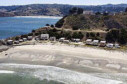
is a 17-acre (6.9 ha) beach neighborhood at the southerly edge of
230:
tourist destination. Shelter Cove was a picnic day stop along the
40:
226:
Historically the cove has been a recreational beach and popular
411:
California
Coastal Commission prescriptive easement application
201:
190:
31:
311:"City of Pacifica v Arno Rohloff and Does 1 - 50"
218:consisting of seventeen rustic rental cottages.
238:up until the 1940s. A restaurant and bar, the
8:
325:City of Pacifica Shelter Cove access lawsuit
284:. Los Altos, Calif: Cherry Orchard Books.
28:
372:"Pacifica Boat Docks Historical Pictures"
305:
303:
301:
234:during its heyday, and later through the
431:Beaches of San Mateo County, California
339:"Beach may be reclaimed for public use"
261:
200:
189:
58:
46:
7:
133:
103:
73:
337:Scott, Julia (November 26, 2007).
86:Show map of San Francisco Bay Area
25:
132:
125:
102:
95:
72:
65:
48:
406:Pacifica Riptide, Shelter Cove.
1:
400:Coastal Records Project photo
247:California Coastal Commission
146:Show map of the United States
282:Shelter Cove The Early Years
447:
280:Lafayette, Lenore (1997).
155:
59:
47:
38:
175:37.59694°N 122.51389°W
116:Show map of California
18:Shelter Cove, Pacifica
353:"Planning Commission"
426:Pacifica, California
232:Ocean Shore Railroad
216:Pacifica, California
195:Pacifica, California
180:37.59694; -122.51389
359:. January 20, 2009.
171: /
341:. East Bay Times.
209:
208:
16:(Redirected from
438:
387:
386:
384:
382:
367:
361:
360:
357:City of Pacifica
349:
343:
342:
334:
328:
327:
322:
320:
315:
307:
296:
295:
277:
271:
266:
186:
185:
183:
182:
181:
176:
172:
169:
168:
167:
164:
147:
136:
135:
129:
117:
106:
105:
99:
87:
76:
75:
69:
52:
29:
21:
446:
445:
441:
440:
439:
437:
436:
435:
416:
415:
396:
391:
390:
380:
378:
370:Wilson, Brian.
369:
368:
364:
351:
350:
346:
336:
335:
331:
318:
316:
313:
309:
308:
299:
292:
279:
278:
274:
267:
263:
258:
236:Prohibition Era
224:
179:
177:
173:
170:
165:
162:
160:
158:
157:
151:
150:
149:
148:
145:
144:
143:
142:
141:
137:
120:
119:
118:
115:
114:
113:
112:
111:
107:
90:
89:
88:
85:
84:
83:
82:
81:
77:
55:
43:
34:
23:
22:
15:
12:
11:
5:
444:
442:
434:
433:
428:
418:
417:
414:
413:
408:
403:
395:
394:External links
392:
389:
388:
362:
344:
329:
297:
290:
272:
260:
259:
257:
254:
223:
220:
207:
206:
203:
199:
198:
192:
188:
187:
153:
152:
139:
138:
131:
130:
124:
123:
122:
121:
109:
108:
101:
100:
94:
93:
92:
91:
79:
78:
71:
70:
64:
63:
62:
61:
60:
57:
56:
53:
45:
44:
39:
36:
35:
32:
24:
14:
13:
10:
9:
6:
4:
3:
2:
443:
432:
429:
427:
424:
423:
421:
412:
409:
407:
404:
401:
398:
397:
393:
377:
373:
366:
363:
358:
354:
348:
345:
340:
333:
330:
326:
312:
306:
304:
302:
298:
293:
291:0-9661779-9-1
287:
283:
276:
273:
270:
265:
262:
255:
253:
250:
248:
243:
241:
237:
233:
229:
228:San Francisco
221:
219:
217:
213:
204:
196:
193:
184:
156:Coordinates:
154:
128:
98:
68:
51:
42:
37:
30:
27:
19:
379:. Retrieved
376:ski-epic.com
375:
365:
356:
347:
332:
324:
317:. Retrieved
281:
275:
264:
251:
244:
240:Clipper Ship
239:
225:
212:Shelter Cove
211:
210:
140:Shelter Cove
110:Shelter Cove
80:Shelter Cove
54:Shelter Cove
33:Shelter Cove
26:
178: /
166:122°30′50″W
420:Categories
256:References
222:Background
163:37°35′49″N
319:March 27,
202:Elevation
191:Location
381:July 9,
288:
314:(PDF)
197:, USA
41:Beach
383:2018
321:2008
286:ISBN
205:0 m
422::
374:.
355:.
323:.
300:^
402:.
385:.
294:.
20:)
Text is available under the Creative Commons Attribution-ShareAlike License. Additional terms may apply.