854:
102:
122:
556:
In the town, the population was spread out, with 28.4% under the age of 18, 7.2% from 18 to 24, 26.7% from 25 to 44, 27.6% from 45 to 64, and 10.2% who were 65 years of age or older. The median age was 37 years. For every 100 females, there were 115.4 males. For every 100 females age 18 and over,
552:
living together, 6.8% had a female householder with no husband present, and 18.4% were non-families. 14.6% of all households were made up of individuals, and 4.1% had someone living alone who was 65 years of age or older. The average household size was 2.81 and the average family size was 3.07.
49:
331:
The
Surface in this Township is generally level and a fair proportion good fertile soil. It is well watered by numerous small Streams, none of which, however, afford any water power. A large part of the township is well timbered with
1207:
560:
The median income for a household in the town was $ 37,639, and the median income for a family was $ 40,833. Males had a median income of $ 28,750 versus $ 21,071 for females. The
770:
517:
was 23.1 people per square mile (8.9/km). There were 307 housing units at an average density of 8.6 per square mile (3.3/km). The racial makeup of the town was 98.18%
416:, Sigel has a total area of 35.8 square miles (92.8 km), of which 35.7 square miles (92.5 km) is land and 0.2 square miles (0.4 km), or 0.38%, is water.
1119:
1202:
62:
727:
763:
250:
1139:
315:
981:
931:
370:
1099:
936:
756:
577:
260:
1109:
976:
916:
700:
17:
213:
603:
748:
1094:
522:
1149:
526:
401:
134:
1069:
397:
1212:
1144:
632:
534:
413:
656:
48:
1134:
780:
409:
287:
139:
926:
826:
802:
480:
465:
450:
299:
271:
1172:
986:
238:
94:
1044:
1026:
941:
548:
There were 294 households, out of which 40.1% had children under the age of 18 living with them, 68.0% were
314:
in the fall of 1848 by crews working for the U.S. government. In
September 1849 another crew marked all the
1064:
951:
921:
882:
538:
243:
1129:
1084:
887:
836:
333:
657:"Geographic Identifiers: 2010 Demographic Profile Data (G001): Sigel town, Chippewa County, Wisconsin"
1179:
1039:
542:
357:
223:
1114:
1054:
1034:
1016:
864:
530:
518:
1104:
1079:
1011:
996:
961:
842:
831:
821:
514:
381:
361:
678:
1089:
1074:
1006:
971:
946:
911:
877:
561:
405:
369:
For a surveyor's description of the six mile square that includes the west half of Sigel, see
319:
564:
for the town was $ 15,635. About 5.0% of families and 7.1% of the population were below the
1124:
966:
956:
906:
898:
813:
513:
of 2000, there were 825 people, 294 households, and 239 families residing in the town. The
393:
991:
872:
345:
392:
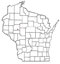
The town of Sigel is located in southern
Chippewa County, bordered to the east by the
1196:
323:
107:
565:
318:
of the eastern half of Sigel, walking the woods and swamps on foot, measuring with
795:
377:
349:
291:
114:
77:
64:
311:
295:
204:
127:
568:, including 8.3% of those under age 18 and 10.6% of those age 65 or over.
1163:‡This populated place also has portions in an adjacent county or counties
549:
337:
510:
230:
209:
326:. When done, the deputy surveyor filed this general description:
376:
The town was founded on
January 3, 1863, presumably named after
39:
752:
353:
341:
852:
599:
628:
408:. The Yellow River is a west-flowing tributary of the
16:
For other towns in the U.S. state of
Wisconsin, see
1158:
1053:
1025:
897:
863:
812:
270:
259:
249:
237:
220:
203:
195:
187:
182:
174:
166:
158:
150:
145:
133:
113:
93:
30:
277:East half of T28N R6W and west half of T28N R7W
764:
705:Original Field Notes and Plat Maps, 1833-1866
651:
649:
8:
1208:Eau Claire–Chippewa Falls metropolitan area
771:
757:
749:
545:of any race were 0.24% of the population.
423:
27:
659:. U.S. Census Bureau, American Factfinder
380:, a colonel in the Union Army during the
734:. Board of Commissioners of Public Lands
707:. Board of Commissioners of Public Lands
681:. Board of Commissioners of Public Lands
588:
248:
236:
202:
181:
173:
144:
92:
57:
45:
443:
623:
621:
594:
592:
400:. It is bordered to the north by the
310:The area that became Sigel was first
269:
258:
219:
194:
186:
165:
157:
149:
132:
112:
7:
537:, and 0.73% from two or more races.
1203:Towns in Chippewa County, Wisconsin
728:"Interior Field Notes (Sept. 1849)"
578:School District of Cadott Community
162:35.7 sq mi (92.5 km)
154:35.8 sq mi (92.8 km)
779:Municipalities and communities of
433:
302:, up from 825 at the 2000 census.
298:. The population was 1,044 at the
14:
170:0.2 sq mi (0.4 km)
120:
100:
47:
25:Town in Wisconsin, United States
604:United States Geological Survey
600:"US Board on Geographic Names"
1:
53:Location of Sigel, Wisconsin
633:United States Census Bureau
414:United States Census Bureau
1229:
782:Chippewa County, Wisconsin
701:"Field Notes for T28N R6W"
15:
1168:
850:
793:
679:"Land Survey Information"
494:
479:
464:
449:
442:
437:
432:
429:
58:
46:
37:
557:there were 114.1 males.
178:961 ft (293 m)
576:Sigel is served by the
199:29/sq mi (11.3/km)
857:
396:, and to the south by
367:
856:
629:"U.S. Census website"
425:Historical population
328:
222: • Summer (
78:44.90250°N 91.17250°W
1181:United States portal
196: • Density
426:
412:. According to the
404:and the village of
83:44.90250; -91.17250
74: /
1213:Towns in Wisconsin
858:
606:. October 25, 2007
515:population density
424:
382:American Civil War
188: • Total
167: • Water
151: • Total
1190:
1189:
732:Land Survey Notes
562:per capita income
507:
506:
398:Eau Claire County
281:
280:
159: • Land
1220:
1182:
1175:
1174:Wisconsin portal
855:
805:
798:
788:
783:
773:
766:
759:
750:
744:
743:
741:
739:
723:
717:
716:
714:
712:
697:
691:
690:
688:
686:
675:
669:
668:
666:
664:
653:
644:
643:
641:
639:
625:
616:
615:
613:
611:
596:
523:African American
445:
440:
435:
427:
227:
126:
124:
123:
106:
104:
103:
89:
88:
86:
85:
84:
79:
75:
72:
71:
70:
67:
51:
32:Sigel, Wisconsin
28:
18:Sigel, Wisconsin
1228:
1227:
1223:
1222:
1221:
1219:
1218:
1217:
1193:
1192:
1191:
1186:
1180:
1173:
1164:
1154:
1135:Old Albertville
1056:
1055:Unincorporated
1049:
1021:
893:
859:
853:
848:
808:
803:
796:
789:
786:
781:
777:
747:
737:
735:
725:
724:
720:
710:
708:
699:
698:
694:
684:
682:
677:
676:
672:
662:
660:
655:
654:
647:
637:
635:
627:
626:
619:
609:
607:
598:
597:
590:
586:
574:
550:married couples
527:Native American
438:
422:
390:
316:section corners
308:
288:Chippewa County
221:
121:
119:
101:
99:
82:
80:
76:
73:
68:
65:
63:
61:
60:
54:
42:
33:
26:
21:
12:
11:
5:
1226:
1224:
1216:
1215:
1210:
1205:
1195:
1194:
1188:
1187:
1185:
1184:
1177:
1169:
1166:
1165:
1162:
1160:
1156:
1155:
1153:
1152:
1147:
1142:
1137:
1132:
1127:
1122:
1117:
1112:
1107:
1102:
1097:
1092:
1087:
1082:
1077:
1072:
1067:
1061:
1059:
1051:
1050:
1048:
1047:
1042:
1037:
1031:
1029:
1023:
1022:
1020:
1019:
1014:
1009:
1004:
999:
994:
989:
984:
979:
974:
969:
964:
959:
954:
949:
944:
939:
934:
929:
924:
919:
914:
909:
903:
901:
895:
894:
892:
891:
885:
880:
875:
869:
867:
861:
860:
851:
849:
847:
846:
840:
834:
829:
827:Chippewa Falls
824:
818:
816:
810:
809:
804:Chippewa Falls
794:
791:
790:
778:
776:
775:
768:
761:
753:
746:
745:
718:
692:
670:
645:
617:
587:
585:
582:
573:
570:
505:
504:
501:
499:
496:
492:
491:
488:
486:
483:
477:
476:
473:
471:
468:
462:
461:
458:
456:
453:
447:
446:
441:
436:
431:
421:
418:
410:Chippewa River
389:
386:
307:
304:
279:
278:
275:
268:
267:
264:
257:
256:
253:
247:
246:
241:
235:
234:
228:
218:
217:
207:
201:
200:
197:
193:
192:
189:
185:
184:
180:
179:
176:
172:
171:
168:
164:
163:
160:
156:
155:
152:
148:
147:
143:
142:
137:
131:
130:
117:
111:
110:
97:
91:
90:
56:
55:
52:
44:
43:
38:
35:
34:
31:
24:
13:
10:
9:
6:
4:
3:
2:
1225:
1214:
1211:
1209:
1206:
1204:
1201:
1200:
1198:
1183:
1178:
1176:
1171:
1170:
1167:
1161:
1157:
1151:
1148:
1146:
1143:
1141:
1138:
1136:
1133:
1131:
1128:
1126:
1123:
1121:
1118:
1116:
1113:
1111:
1108:
1106:
1103:
1101:
1098:
1096:
1093:
1091:
1088:
1086:
1083:
1081:
1078:
1076:
1073:
1071:
1068:
1066:
1063:
1062:
1060:
1058:
1052:
1046:
1043:
1041:
1038:
1036:
1033:
1032:
1030:
1028:
1024:
1018:
1015:
1013:
1010:
1008:
1005:
1003:
1000:
998:
995:
993:
990:
988:
987:Lake Holcombe
985:
983:
980:
978:
975:
973:
970:
968:
965:
963:
960:
958:
955:
953:
950:
948:
945:
943:
940:
938:
935:
933:
930:
928:
925:
923:
920:
918:
915:
913:
910:
908:
905:
904:
902:
900:
896:
889:
886:
884:
881:
879:
876:
874:
871:
870:
868:
866:
862:
844:
841:
838:
835:
833:
830:
828:
825:
823:
820:
819:
817:
815:
811:
807:
806:
799:
792:
787:United States
784:
774:
769:
767:
762:
760:
755:
754:
751:
733:
729:
726:Welsh, H. B.
722:
719:
706:
702:
696:
693:
680:
674:
671:
663:September 18,
658:
652:
650:
646:
634:
630:
624:
622:
618:
605:
601:
595:
593:
589:
583:
581:
579:
571:
569:
567:
563:
558:
554:
551:
546:
544:
540:
536:
533:, 0.24% from
532:
528:
524:
520:
516:
512:
502:
500:
497:
493:
489:
487:
484:
482:
478:
474:
472:
469:
467:
463:
459:
457:
454:
452:
448:
428:
419:
417:
415:
411:
407:
403:
399:
395:
394:Town of Edson
387:
385:
383:
379:
374:
372:
366:
365:
363:
359:
355:
351:
347:
343:
339:
335:
327:
325:
321:
317:
313:
305:
303:
301:
297:
293:
289:
286:is a town in
285:
276:
273:
265:
262:
254:
252:
245:
244:715 & 534
242:
240:
232:
229:
225:
215:
214:Central (CST)
211:
208:
206:
198:
190:
177:
169:
161:
153:
141:
138:
136:
129:
118:
116:
109:
108:United States
98:
96:
87:
59:Coordinates:
50:
41:
36:
29:
23:
19:
1045:Lake Wissota
1001:
942:Cooks Valley
801:
736:. Retrieved
731:
721:
709:. Retrieved
704:
695:
683:. Retrieved
673:
661:. Retrieved
636:. Retrieved
608:. Retrieved
575:
566:poverty line
559:
555:
547:
508:
420:Demographics
402:Yellow River
391:
375:
368:
330:
329:
309:
283:
282:
239:Area code(s)
22:
1110:Eagle Point
1065:Albertville
1057:communities
952:Eagle Point
922:Birch Creek
883:Lake Hallie
797:County seat
638:January 31,
610:January 31,
535:other races
495:2020 (est.)
378:Franz Sigel
300:2010 census
81: /
1197:Categories
1140:Pine Grove
1130:Maple Hill
1085:Brownville
888:New Auburn
837:Eau Claire
584:References
509:As of the
292:U.S. state
263:feature ID
183:Population
69:91°10′21″W
1159:Footnotes
1040:Jim Falls
982:Lafayette
932:Cleveland
738:March 23,
711:March 23,
685:March 26,
572:Education
388:Geography
371:Lafayette
360:and Some
296:Wisconsin
251:FIPS code
205:Time zone
175:Elevation
128:Wisconsin
66:44°54′9″N
1115:Eagleton
1100:Crescent
1035:Holcombe
1017:Woodmohr
865:Villages
539:Hispanic
529:, 0.24%
525:, 0.48%
521:, 0.12%
358:Ironwood
312:surveyed
274:township
255:55-73875
140:Chippewa
1105:Drywood
1095:Colburn
1080:Bateman
1012:Wheaton
997:Sampson
962:Estella
937:Colburn
927:Bloomer
843:Stanley
832:Cornell
822:Bloomer
324:compass
306:History
290:in the
266:1584159
95:Country
1150:Tilden
1120:Howard
1090:Cobban
1075:Arnold
1007:Tilden
977:Howard
972:Hallie
947:Delmar
917:Auburn
912:Arthur
878:Cadott
814:Cities
543:Latino
511:census
430:Census
406:Cadott
135:County
125:
105:
1125:Huron
1070:Anson
1002:Sigel
967:Goetz
957:Edson
907:Anson
899:Towns
531:Asian
519:White
498:1,095
490:26.5%
485:1,044
475:12.1%
350:Sugar
334:Birch
320:chain
284:Sigel
233:(CDT)
231:UTC-5
210:UTC-6
191:1,044
115:State
1145:Ruby
1027:CDPs
992:Ruby
873:Boyd
740:2013
713:2013
687:2011
665:2015
640:2008
612:2008
503:4.9%
481:2010
466:2000
451:1990
439:Note
434:Pop.
362:Pine
346:Lind
322:and
272:PLSS
261:GNIS
146:Area
40:Town
541:or
470:825
455:736
354:Oak
342:Elm
338:Ash
294:of
224:DST
1199::
800::
785:,
730:.
703:.
648:^
631:.
620:^
602:.
591:^
580:.
444:%±
384:.
373:.
356:,
352:,
348:,
344:,
340:,
336:,
890:‡
845:‡
839:‡
772:e
765:t
758:v
742:.
715:.
689:.
667:.
642:.
614:.
460:—
364:.
226:)
216:)
212:(
20:.
Text is available under the Creative Commons Attribution-ShareAlike License. Additional terms may apply.