271:
134:
127:
29:
424:, is also known as the "roof of Málaga". The name is derived from a large and deep cavity near the top. Ropes (maromas) were used to climb down into it to collect snow. The mountain can be climbed by several routes, of which the most traditional starts from the center of
448:. At an altitude of 1,700 metres (5,600 ft) the annual average precipitation is slightly more than 900 millimetres (35 in). The Sierre de Tejeda receives a total of 8.6 cubic hectometres (300,000,000 cu ft) of rainfall in an average year.
862:
García Alix, Antonio; Minwer
Barakat, Raef; Martín, José M.; Martín Suárez, Elvira; Freudenthal, Matthijs (July–August 2009), "Dating The Change From Endorheic To Exorheic Conditions In The Drainage System Of The Granada Basin (Southern Spain)",
477:
land lower down in the slopes of the
Almanchares river basin. The Fajara cave was used in the Neolithic era, and the Rábita cave shows evidence of iron ore extraction in Roman times. Three bridges on the slopes of the sierra in the towns of
451:
Annual average temperature at the
Pantano de los Bermejales station at the foot of the Sierra is about 8 °C (46 °F). Higher in the mountains the temperatures range from 0 to 22 °C (32 to 72 °F). The flora are mostly
408:(1839–1902) explained the earthquake as having been caused by movement along the faults that bound the Tejeda / Almijara massif to the north and south. Others thought the cause might have been the collapse of underground cavities.
464:
The early hominids in the region would have moved from caves on the coast to caves in the Sierra de Tejeda on a seasonal basis. The 40,000 year old bones of a
Neanderthal man have been found in the Boquete de Zafarraya cave in
315:(yew) trees in the past.. There are a few remnants of these pines on La Maroma, including one at the Salto del Caballo near the peak. A small group is found in the upper part of the Barranco del Cañuelo in the municipality of
926:
Gutiérrez Larena, Belén; Fuertes
Aguilar, Javier; Nieto Feliner, Gonzalo (September 2006), "Dispersal across Southern Iberian Refugia? Integrating RAPDs, Sequence Data and Morphometrics in Armeria (Plumbaginaceae)",
806:
404:
were almost completely destroyed. The epicenter was on the northern side of the Sierra Tejeda near Ventas de
Zefarraya, with a focus 12,300 metres (40,400 ft) deep. The pioneering geologist
456:. There are many plant species common to the western Sierra Nevada and the Tejeda/Almijara range, which may have migrated between these regions via the intermediate Sierra de las Guájaras.
444:
The mountains have relatively high levels of rainfall, with highest rainfall in
December, January and March, and lowest in July. Annual rainfall is 1,000 millimetres (39 in) in
259:
955:
420:(La Maroma) is 2,065 metres (6,775 ft) high, and commands dramatic views of the surrounding mountains and the Mediterranean coast. The Pico Tejeda, commonly called
1086:
1081:
373:
cobbles and boulders up to 1 metre (3 ft 3 in) in diameter. The Sierra
Almijara and Sierra Tejeda form the southern margin of the western part of the
971:
473:
is at the foot of the Sierra, at an altitude of 649 metres (2,129 ft), in the region between the marbles of the Sierra de Tejeda and the
1071:
1045:
910:
385:
sediments exposed in the northwest of the
Granada basin were washed down by the Cacín from the Alpujarride reliefs of the Almijara/Tejeda.
270:
68:
988:
Udías, Agustín (2013), "Development Of
Seismology In Spain In The Context Of The Three Large Earthquakes Of 1755, 1884 And 1954",
768:
126:
286:. It covers an area of 6,755 square kilometres (2,608 sq mi). The Sierre de Tejeda lies to the southeast of the
278:
The Sierra de Tejeda is a small mountain range running in a northwest to southeast direction. It lies in the east of the
788:
61:
250:
to the west it constitutes a limestone massif that acts as a physical border between the two provinces, separating the
1076:
405:
389:
428:. Other routes start from the Alcázar recreational area and from the Llanadas de Sedella in the municipality of
808:
Anexo II Plan de Ordenación de los Recursos Naturales del Parque Natural Sierras de Tejada, Almijara y Alhama
200:
374:
295:
255:
279:
235:
174:
294:. The Sierras of Tejida and Almijara form a single range about 40 kilometres (25 mi) west of the
872:
470:
425:
487:
397:
283:
239:
190:
178:
1005:
944:
888:
291:
243:
212:
1041:
1035:
906:
900:
433:
401:
231:
548:
546:
997:
972:"Sierra De Tejeda: Subida Norte a La Maroma (2.066m) desde El Robledal en Alhama de Granada"
936:
880:
287:
247:
1017:
844:
336:
331:
of Southern Spain. This part of the Betic cordilla has folds verging southwards from the
1001:
876:
28:
393:
378:
355:
205:
1065:
328:
307:
110:
The name "Tejeda'" refers to the abundance of Taxus baccata (yew) trees in the past.
359:
466:
445:
429:
366:
332:
316:
251:
884:
578:
576:
343:, and the fault surfaces are in turn cut by later NNW-directed faults from the
490:
are said to have a Roman origin, although their appearance today is medieval.
392:
had an estimated magnitude of 6.5. There were 745 deaths, and the villages of
217:
789:"Los enclaves más espectaculares en las sierras de Tejeda, Almijara y Alhama"
83:
70:
739:
647:
552:
537:
421:
417:
351:
344:
340:
164:
105:
44:
298:. The mountains form part of a barrier between the coast and the interior.
382:
363:
1009:
948:
892:
362:
deposits up to 30 metres (98 ft) thick of conglomerates, sands and
940:
483:
479:
469:, in a spur of the Sierra de Alhama just west of the Sierra de Tejeda.
432:. One of the simplest routes is on its north face in the territory of
474:
370:
51:
826:
770:
10 Años de Estudio Sobre Taxus Baccata (Tejo) y la Sierra de Tejeda
453:
269:
595:
593:
591:
582:
849:
Caminando por la Historia de la provincia • Gran Senda de Málaga
506:
504:
502:
354:. The rocks belong to the Alpujarride complex. They include
740:
Gutiérrez Larena, Fuertes Aguilar & Nieto Feliner 2006
712:
553:
Gutiérrez Larena, Fuertes Aguilar & Nieto Feliner 2006
538:
Gutiérrez Larena, Fuertes Aguilar & Nieto Feliner 2006
339:
caused by extensional detachments in the Sierra de Tejeda
696:
694:
692:
521:
519:
871:(7/8), SEPM Society for Sedimentary Geology: 544–549,
327:
The Sierra de Tejeda is in the central section of the
1018:"Sierras of Tejeda, Almijara and Almara Natural Park"
827:"Sierras de Alhama, Tejeda and Almijara Natural Park"
563:
561:
957:
Parque natural Sierras de Tejeda, Almijara y Alhama
436:, starting from the El Robledal recreational area.
260:
Sierras of Tejeda, Almijara and Alhama Natural Park
211:
199:
189:
184:
170:
160:
152:
114:
104:
99:
60:
50:
40:
35:
21:
1034:Wisshak, Max; Tapanila, Leif (20 September 2008),
996:(2), History of Earth Sciences Society: 186–203,
723:
721:
611:
599:
510:
623:
350:The most common rock in the Sierra Tejeda is
8:
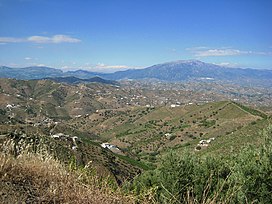
274:Alcaucín - Canillas de Aceituno, April 2013
700:
18:
1040:, Springer Science & Business Media,
845:"Etapa 8, Canillas de Aceituno - Periana"
525:
133:
787:Almellones, Javier (23 February 2019),
498:
335:age. The folds are cut by WSW-directed
814:(in Spanish), Junta de Andalucia, 2016
369:. The bioclastic calcarenites contain
234:of mountains between the provinces of
899:Gibbons, Wes; Moreno, Teresa (2002),
683:
671:
659:
583:Parque natural ... Junta de Andalucía
7:
1082:Geography of the Province of Granada
635:
1087:Geography of the Province of Málaga
1002:10.17704/eshi.32.2.f1168212m214l532
751:
567:
1037:Current Developments in Bioerosion
851:(in Spanish), Diputación de Málaga
727:
14:
377:, and contain tributaries of the
960:(in Spanish), Junta de Andalucía
905:, Geological Society of London,
132:
125:
27:
713:Sierra De Tejeda: Subida Norte
305:" refers to the abundance of
1:
776:, Ceder Axarquía, 2 June 2009
258:. The mountains contain the
1072:Mountain ranges of Andalusia
290:and to the northwest of the
242:in Spain. Together with the
56:2,066 m (6,778 ft)
511:Wisshak & Tapanila 2008
230:is a mountain range in the
1103:
885:10.2110/palo.2009.p09-015r
390:1884 Andalusian earthquake
624:Gibbons & Moreno 2002
282:and the southwest of the
119:
26:
935:(3), Springer: 305–322,
648:García Alix et al. 2009
406:José Macpherson y Hemas
16:Mountain range in Spain
990:Earth Sciences History
275:
84:36.904910°N 4.036516°W
612:10 Años de Estudio...
600:10 Años de Estudio...
375:depression of Granada
273:
256:depression of Granada
902:The Geology of Spain
795:(in Spanish), Málaga
471:Canillas de Aceituno
426:Canillas de Aceituno
246:to the east and the
161:Autonomous community
89:36.904910; -4.036516
877:2009Palai..24..544G
488:Canillas de Albaida
398:Ventas de Zafarraya
80: /
941:10.1007/BF02904944
292:Sierra de Almijara
276:
244:Sierra de Almijara
36:Highest point
1077:Penibaetic System
1047:978-3-540-77598-0
929:Folia Geobotanica
912:978-1-86239-110-9
825:Arenas, Antonio,
434:Alhama de Granada
402:Alhama de Granada
232:Penibaetic System
224:
223:
195:300 million years
1094:
1057:
1056:
1054:
1030:
1029:
1028:
1012:
984:
983:
982:
967:
966:
965:
951:
922:
921:
919:
895:
858:
857:
856:
840:
839:
838:
821:
820:
819:
813:
802:
801:
800:
783:
782:
781:
775:
755:
749:
743:
737:
731:
725:
716:
710:
704:
698:
687:
681:
675:
669:
663:
657:
651:
645:
639:
633:
627:
621:
615:
609:
603:
597:
586:
580:
571:
565:
556:
550:
541:
535:
529:
523:
514:
508:
288:Sierra de Alhama
248:Sierra de Alhama
228:Sierra de Tejeda
140:Sierra de Tejeda
136:
135:
129:
95:
94:
92:
91:
90:
85:
81:
78:
77:
76:
73:
31:
22:Sierra de Tejeda
19:
1102:
1101:
1097:
1096:
1095:
1093:
1092:
1091:
1062:
1061:
1060:
1052:
1050:
1048:
1033:
1026:
1024:
1015:
987:
980:
978:
970:
963:
961:
954:
925:
917:
915:
913:
898:
861:
854:
852:
843:
836:
834:
824:
817:
815:
811:
805:
798:
796:
786:
779:
777:
773:
767:
763:
758:
750:
746:
738:
734:
726:
719:
711:
707:
701:Almellones 2019
699:
690:
682:
678:
670:
666:
658:
654:
646:
642:
634:
630:
622:
618:
610:
606:
598:
589:
581:
574:
566:
559:
551:
544:
536:
532:
524:
517:
509:
500:
496:
462:
442:
414:
325:
268:
148:
147:
146:
145:
144:
143:
142:
141:
137:
88:
86:
82:
79:
74:
71:
69:
67:
66:
17:
12:
11:
5:
1100:
1098:
1090:
1089:
1084:
1079:
1074:
1064:
1063:
1059:
1058:
1046:
1031:
1016:Williams, Jo,
1013:
985:
968:
952:
923:
911:
896:
859:
841:
831:Waste Magazine
822:
803:
784:
764:
762:
759:
757:
756:
754:, p. 156.
744:
742:, p. 319.
732:
717:
705:
688:
686:, p. 196.
676:
674:, p. 194.
664:
662:, p. 191.
652:
650:, p. 545.
640:
628:
626:, p. 405.
616:
604:
587:
572:
570:, p. 155.
557:
555:, p. 307.
542:
540:, p. 306.
530:
515:
513:, p. 440.
497:
495:
492:
461:
460:Human presence
458:
441:
438:
413:
410:
394:Arenas del Rey
324:
321:
267:
264:
222:
221:
215:
209:
208:
206:Mountain range
203:
197:
196:
193:
187:
186:
182:
181:
172:
168:
167:
162:
158:
157:
154:
150:
149:
139:
138:
131:
130:
124:
123:
122:
121:
120:
117:
116:
112:
111:
108:
102:
101:
97:
96:
64:
58:
57:
54:
48:
47:
42:
38:
37:
33:
32:
24:
23:
15:
13:
10:
9:
6:
4:
3:
2:
1099:
1088:
1085:
1083:
1080:
1078:
1075:
1073:
1070:
1069:
1067:
1049:
1043:
1039:
1038:
1032:
1023:
1022:Andalucia.com
1019:
1014:
1011:
1007:
1003:
999:
995:
991:
986:
977:
973:
969:
959:
958:
953:
950:
946:
942:
938:
934:
930:
924:
914:
908:
904:
903:
897:
894:
890:
886:
882:
878:
874:
870:
866:
860:
850:
846:
842:
832:
828:
823:
810:
809:
804:
794:
790:
785:
772:
771:
766:
765:
760:
753:
748:
745:
741:
736:
733:
729:
724:
722:
718:
714:
709:
706:
702:
697:
695:
693:
689:
685:
680:
677:
673:
668:
665:
661:
656:
653:
649:
644:
641:
637:
632:
629:
625:
620:
617:
614:, p. 14.
613:
608:
605:
602:, p. 13.
601:
596:
594:
592:
588:
584:
579:
577:
573:
569:
564:
562:
558:
554:
549:
547:
543:
539:
534:
531:
528:, p. 13.
527:
526:Anexo II 2016
522:
520:
516:
512:
507:
505:
503:
499:
493:
491:
489:
485:
481:
476:
472:
468:
459:
457:
455:
449:
447:
439:
437:
435:
431:
427:
423:
419:
411:
409:
407:
403:
399:
395:
391:
386:
384:
380:
376:
372:
368:
365:
361:
357:
353:
348:
346:
342:
338:
334:
330:
322:
320:
318:
314:
310:
309:
308:Taxus baccata
304:
299:
297:
296:Sierra Nevada
293:
289:
285:
281:
272:
265:
263:
261:
257:
253:
249:
245:
241:
237:
233:
229:
219:
216:
214:
210:
207:
204:
202:
201:Mountain type
198:
194:
192:
188:
183:
180:
176:
173:
169:
166:
163:
159:
155:
151:
128:
118:
113:
109:
107:
103:
98:
93:
65:
63:
59:
55:
53:
49:
46:
43:
39:
34:
30:
25:
20:
1051:, retrieved
1036:
1025:, retrieved
1021:
993:
989:
979:, retrieved
975:
962:, retrieved
956:
932:
928:
916:, retrieved
901:
868:
864:
853:, retrieved
848:
835:, retrieved
833:(in Spanish)
830:
816:, retrieved
807:
797:, retrieved
792:
778:, retrieved
769:
747:
735:
708:
679:
667:
655:
643:
631:
619:
607:
533:
463:
450:
443:
416:The peak of
415:
387:
367:calcarenites
360:Late Miocene
349:
326:
312:
306:
302:
300:
277:
227:
225:
213:Type of rock
412:Pico Tejeda
379:Cacín River
333:Burdigalian
329:Betic Range
191:Age of rock
87: /
62:Coordinates
1066:Categories
1027:2019-08-14
981:2019-08-16
964:2019-08-14
855:2019-05-18
837:2019-08-15
818:2019-08-17
799:2019-08-16
793:Diario Sur
780:2019-08-18
684:Udías 2013
672:Udías 2013
660:Udías 2013
364:bioclastic
301:The name "
220:formations
218:Calcareous
72:36°54′18″N
1053:16 August
976:AristaSur
918:16 August
422:La Maroma
352:limestone
345:Tortonian
341:anticline
254:from the
171:Provinces
165:Andalusia
115:Geography
106:Etymology
75:4°02′11″W
52:Elevation
45:La Maroma
1010:24140011
949:25134150
893:40606444
636:Williams
467:Alcaucín
446:Alcaucín
430:Alcaucín
383:Pliocene
317:Alcaucín
266:Location
252:Axarquía
873:Bibcode
865:PALAIOS
761:Sources
752:Etapa 8
568:Etapa 8
484:Salares
480:Sedella
440:Climate
323:Geology
303:Tejeda'
284:Granada
240:Granada
185:Geology
179:Granada
153:Country
1044:
1008:
947:
909:
891:
728:Arenas
475:schist
418:Tejeda
371:marble
356:Middle
337:faults
280:Málaga
236:Málaga
175:Málaga
100:Naming
1006:JSTOR
945:JSTOR
889:JSTOR
812:(PDF)
774:(PDF)
494:Notes
454:xeric
347:age.
313:tejos
311:, or
156:Spain
1055:2019
1042:ISBN
920:2019
907:ISBN
486:and
400:and
388:The
358:and
238:and
226:The
177:and
41:Peak
998:doi
937:doi
881:doi
1068::
1020:,
1004:,
994:32
992:,
974:,
943:,
933:41
931:,
887:,
879:,
869:24
867:,
847:,
829:,
791:,
720:^
691:^
590:^
575:^
560:^
545:^
518:^
501:^
482:,
396:,
381:.
319:.
262:.
1000::
939::
883::
875::
730:.
715:.
703:.
638:.
585:.
Text is available under the Creative Commons Attribution-ShareAlike License. Additional terms may apply.