45:
430:
563:
474:
446:
460:
29:
52:
402:, one of two major tributaries of the Chao Phraya including the Nan. The Bhumibol and Sirkit Dams control 22% of the Chao Phraya's annual runoff combined. Both dams also help provide for the irrigation of 1,200,000 ha (4,633 sq mi) in the wet season and 480,000 ha (1,853 sq mi) in the dry season.
393:
The
Sirikit Dam among others in the Chao Phraya basin were constructed beginning in the 1950s to exploit the agricultural and hydroelectric potential of the basin. Preliminary construction on the dam began in 1968 and it was finished in 1972. The power plant and first three units were commissioned in
419:) is active or "useful" storage. The reservoir has a surface area of 259 km (100 sq mi). The dam's spillway consists of a tunnel controlled by two radial gates, it has a capacity of 3,250 m/s (114,773 cu ft/s). The dam's power station contains 4 x 125
410:
The dam is a 113.6 m (373 ft) high and 800 m (2,625 ft) long embankment dam that is 630 m (2,067 ft) wide at its base and 12 m (39 ft) wide at its crest. The dam withholds a reservoir of 9,510,000,000 m
652:
537:
642:
662:
164:
667:
44:
487:
541:
105:
657:
381:. The dam was built for the purpose of irrigation, flood control and hydroelectric power production. It is named after
617:
672:
585:
637:
647:
479:
429:
370:
338:
93:
378:
362:
366:
89:
621:
451:
423:
331:
354:
312:
281:
631:
322:
465:
395:
510:
473:
441:
433:
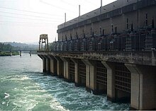
Panorama of the
Sirikit Dam, with on the right, the reservoir of the Nan River
399:
120:
107:
459:
416:
412:
358:
273:
261:
189:
614:
28:
420:
374:
328:
79:
589:
382:
428:
540:. Electricity Generating Authority of Thailand. Archived from
176:
588:. Royal Irrigation Department - Thailand. Archived from
337:
321:
311:
303:
298:
290:
280:
268:
256:
248:
243:
235:
227:
219:
211:
203:
195:
185:
175:
170:
160:
152:
144:
136:
99:
85:
75:
67:
21:
394:1974, the fourth in 1995. Previously in 1964, the
415:) of which 6,666,000,000 m (5,404,214
624:at Electricity Generating Authority of Thailand
653:Buildings and structures in Uttaradit province
8:
165:Electricity Generating Authority of Thailand
239:3,250 m/s (114,773 cu ft/s)
27:
18:
532:
530:
528:
643:Hydroelectric power stations in Thailand
511:"Hydroelectric Power Plants in Thailand"
505:
503:
377:. It is at the southeastern edge of the
663:Energy infrastructure completed in 1974
499:
286:13,130 km (5,070 sq mi)
426:for an installed capacity of 500 MW.
272:6,668,000,000 m (5,405,836
260:9,510,000,000 m (7,709,882
7:
564:"Chao Phraya River Basin (Thailand)"
59:Location of Sirikit Dam in Thailand
51:
33:The dam's power station at its base
488:List of power stations in Thailand
14:
317:75.4 m (247 ft) (rated)
294:259 km (100 sq mi)
472:
458:
444:
50:
43:
668:1974 establishments in Thailand
1:
689:
383:Sirikit, Queen of Thailand
223:630 m (2,067 ft)
207:800 m (2,625 ft)
199:113.6 m (373 ft)
38:
26:
16:Dam in Tha Pla, Uttaradit
480:Renewable energy portal
339:Installed capacity
145:Construction began
658:Dams completed in 1974
434:
236:Spillway capacity
215:12 m (39 ft)
121:17.76389°N 100.56333°E
566:. UNESCO. p. 293
432:
398:was completed on the
361:, a tributary of the
177:Type of dam
592:on 17 September 2008
304:Commission date
269:Active capacity
282:Catchment area
257:Total capacity
126:17.76389; 100.56333
117: /
620:2006-11-07 at the
544:on 5 November 2018
435:
371:Uttaradit Province
228:Spillway type
212:Width (crest)
673:Phi Pan Nam Range
379:Phi Pan Nam Range
363:Chao Phraya River
351:Queen Sirikit Dam
347:
346:
291:Surface area
252:Sirikit Reservoir
220:Width (base)
171:Dam and spillways
153:Opening date
71:Queen Sirikit Dam
680:
638:Dams in Thailand
602:
601:
599:
597:
582:
576:
575:
573:
571:
560:
554:
553:
551:
549:
534:
523:
522:
520:
518:
507:
482:
477:
476:
468:
463:
462:
454:
449:
448:
447:
424:Francis turbines
411:(7,709,882
367:Tha Pla District
132:
131:
129:
128:
127:
122:
118:
115:
114:
113:
110:
54:
53:
47:
31:
19:
688:
687:
683:
682:
681:
679:
678:
677:
648:Embankment dams
628:
627:
622:Wayback Machine
611:
606:
605:
595:
593:
584:
583:
579:
569:
567:
562:
561:
557:
547:
545:
536:
535:
526:
516:
514:
509:
508:
501:
496:
478:
471:
464:
457:
452:Thailand portal
450:
445:
443:
440:
408:
391:
231:Tunnel, service
125:
123:
119:
116:
111:
108:
106:
104:
103:
63:
62:
61:
60:
57:
56:
55:
34:
17:
12:
11:
5:
686:
684:
676:
675:
670:
665:
660:
655:
650:
645:
640:
630:
629:
626:
625:
610:
609:External links
607:
604:
603:
586:"Bhumibol Dam"
577:
555:
524:
498:
497:
495:
492:
491:
490:
484:
483:
469:
455:
439:
436:
407:
404:
390:
387:
355:embankment dam
345:
344:
341:
335:
334:
325:
319:
318:
315:
313:Hydraulic head
309:
308:
305:
301:
300:
296:
295:
292:
288:
287:
284:
278:
277:
270:
266:
265:
258:
254:
253:
250:
246:
245:
241:
240:
237:
233:
232:
229:
225:
224:
221:
217:
216:
213:
209:
208:
205:
201:
200:
197:
193:
192:
187:
183:
182:
179:
173:
172:
168:
167:
162:
158:
157:
154:
150:
149:
146:
142:
141:
138:
134:
133:
101:
97:
96:
87:
83:
82:
77:
73:
72:
69:
65:
64:
58:
49:
48:
42:
41:
40:
39:
36:
35:
32:
24:
23:
15:
13:
10:
9:
6:
4:
3:
2:
685:
674:
671:
669:
666:
664:
661:
659:
656:
654:
651:
649:
646:
644:
641:
639:
636:
635:
633:
623:
619:
616:
613:
612:
608:
591:
587:
581:
578:
565:
559:
556:
543:
539:
538:"Sirikit Dam"
533:
531:
529:
525:
513:. Industcards
512:
506:
504:
500:
493:
489:
486:
485:
481:
475:
470:
467:
461:
456:
453:
442:
437:
431:
427:
425:
422:
418:
414:
405:
403:
401:
397:
388:
386:
384:
380:
376:
372:
368:
364:
360:
356:
352:
342:
340:
336:
333:
330:
326:
324:
320:
316:
314:
310:
306:
302:
299:Power Station
297:
293:
289:
285:
283:
279:
275:
271:
267:
263:
259:
255:
251:
247:
242:
238:
234:
230:
226:
222:
218:
214:
210:
206:
202:
198:
194:
191:
188:
184:
180:
178:
174:
169:
166:
163:
159:
155:
151:
147:
143:
139:
135:
130:
102:
98:
95:
91:
88:
84:
81:
78:
74:
70:
68:Official name
66:
46:
37:
30:
25:
20:
594:. Retrieved
590:the original
580:
568:. Retrieved
558:
546:. Retrieved
542:the original
515:. Retrieved
466:Water portal
409:
396:Bhumibol Dam
392:
350:
348:
332:Francis-type
615:Sirikit Dam
548:6 September
124: /
112:100°33′48″E
100:Coordinates
22:Sirikit Dam
632:Categories
494:References
400:Ping River
389:Background
307:1974, 1995
181:Embankment
109:17°45′50″N
359:Nan River
244:Reservoir
190:Nan River
94:Uttaradit
618:Archived
438:See also
375:Thailand
327:4 x 125
323:Turbines
186:Impounds
161:Owner(s)
86:Location
80:Thailand
596:6 March
570:6 March
517:6 March
417:acre⋅ft
413:acre⋅ft
357:on the
274:acre⋅ft
262:acre⋅ft
249:Creates
90:Tha Pla
76:Country
406:Design
353:is an
343:500 MW
204:Length
196:Height
140:In use
137:Status
365:, in
598:2011
572:2011
550:2016
519:2011
349:The
156:1974
148:1968
634::
527:^
502:^
421:MW
385:.
373:,
369:,
329:MW
92:,
600:.
574:.
552:.
521:.
276:)
264:)
Text is available under the Creative Commons Attribution-ShareAlike License. Additional terms may apply.