1093:
951:
encompasses 1,500 acres (6.1 km); the SGPA remains active in securing additional parcels to add to the property. The SGPA has also been instrumental in defeating attempts to log the Giant, build communications towers on its summits, and close the state park altogether. SGPA runs a regular recreational and interpretive hikes on the Giant and volunteer trail maintenance programs. The
Connecticut Forest and Park Association also has a working investment in the conservation of the Giant and trail building on it. The trail system of the park is also designated as a
254:
111:
389:
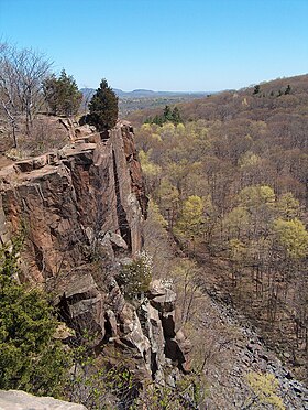
579:. The Giant's profile features distinct "head," "chin," "chest," "hip," "knee," and "feet" sections topographically represented by traprock outcrops and ridge crests. The highest point is the Left Hip, 739 ft (225 m), followed by the Chest, 710 ft (220 m), and the Left Knee and Right Leg, 700 ft (210 m) each, and so on. The Giant's Head, 670 ft (200 m), is marked by a 400 ft (120 m) cliff. A stone observation tower located on the Left Hip, built by the
224:
104:
207:
990:
635:
1105:
261:
231:
1081:
627:
426:
1117:
1129:
3752:
28:
665:
rock. Minor earthquakes have also been measured by seismographs and reported by residents. Basalt is a dark colored rock, but the iron within it weathers to a rusty brown when exposed to the air, lending the ledges a distinct reddish appearance. Basalt frequently breaks into octagonal and pentagonal
854:
On May 15, 2018, a severe microburst caused significant damage to the park, forcing the park's closure. The damage was initially assumed to be from a tornado, but the
National Weather Serviced determined that the tornado ended just west of Sleeping Giant State Park and had transitioned to a 100-mph
831:
Conservation of the Giant began in 1924 with the creation of the
Sleeping Giant Park Association (SGPA) by a group of local residents concerned with ongoing traprock quarrying on the Giant's head. A cottage owner, Judge Willis Cook, had leased his property to the Mount Carmel Traprock Company for
698:
and tilted upward. Subsequent erosion wore away the weaker sedimentary layers at a faster rate than the basalt layers, leaving the abruptly tilted edges of the basalt sheets exposed, creating the distinct linear ridge and dramatic cliff faces visible today. One way to imagine this is to picture a
950:
Most, but not all, of the
Sleeping Giant has been conserved. The trails and facilities on Sleeping Giant are collaboratively maintained by the Sleeping Giant Park Association and the State of Connecticut, with the bulk of the trail maintenance done by the association. Sleeping Giant State Park
735:
block sunlight, creating damp, cooler growing conditions with associated cooler climate plant species. Talus slopes are especially rich in nutrients and support a number of calcium-loving plants uncommon in eastern
Connecticut. Because the ridge generates such varied terrain, it is the home of
1494:
The book won the 2012 Connecticut Press Club Award, the Mom's Choice Awards® Silver
Recipient in 2014 and was Finalist 4 in the American Association of Publishers (AAP) 2015 REVERE Awards for PRE K-12 Learning. A separate teacher's resource guide (98 pp.) is also available from the publisher
836:
forestry professor, the SGPA undertook a ten-year struggle with the traprock operation. The property was purchased by the SGPA in 1933, during the Great
Depression, for $ 30,000; the money was raised through private donations and the property became the Sleeping Giant State Park.
543:. A prominent landscape feature visible for miles, the Sleeping Giant receives its name from its anthropomorphic resemblance to a slumbering human figure as seen from either the north or south. The Giant is known for its expansive clifftop vistas, rugged topography, and
4157:
855:
microburst by the time it reached the park. The microburst was half a mile wide and continued for seven miles. Nearly every pine tree in the main picnic area was toppled. After more than a year of clean up, the park reopened on June 14, 2019.
4097:
1004:
832:
the purpose of quarrying traprock for building materials. The blasting away of what was a beloved landscape feature resulted in public outrage, well reported by local newspapers at the time. Under the leadership of James W. Toumey, a
772:
after several hundred miles of running due south). To prevent him from wreaking such havoc in the future, the good spirit Keitan cast a spell on
Hobbomock to sleep forever as the prominent man-like form of the Sleeping Giant.
690:. These basalt floods of lava happened over a period of 20 million years. Erosion occurring between the eruptions deposited deep layers of sediment between the lava flows, which eventually lithified into
840:
Sleeping Giant State Park was created in 1924, when the SGPA donated 600 acres to the Park and Forest
Commission. The state added an additional 65 acres that year, purchased at a cost of $ 7025.00.
4082:
3370:
360:
1712:
4142:
4117:
4087:
3404:
4162:
3783:
3056:
1759:
4132:
3021:
3967:
3819:
3716:
1792:
253:
3922:
2576:
1187:
820:
took hold in New
England. Summer cottages were built on the Sleeping Giant and many other locations on the Metacomet Ridge. In 1888, John H. Dickerman built a
60:
4147:
4112:
1764:
1705:
4152:
2644:
784:, the Giant decides to get up and leave. The Native American legend is retold (with a few liberties) by Jason J. Marchi in his illustrated children's book
1092:
223:
3987:
3872:
3824:
3814:
2283:
1173:
3397:
2819:
1698:
931:
301:
934:—traverses the length of the Giant from the Quinnipiac River west over the Giant's high points to the Mill River then continues north over
2814:
2298:
1850:
1802:
922:
only is allowed on the Giant (by permit). Seasonal facilities include restrooms, a picnic shelter, and picnic tables. The 23-mile (37 km)
4107:
4077:
3263:
2363:
1928:
103:
2388:
1721:
848:
412:
1274:
4102:
3847:
3438:
3127:
3076:
2986:
2629:
1888:
1164:
4025:
3947:
3390:
3086:
1741:
614:. The west side of Sleeping Giant drains into the Mill River thence to New Haven Harbor and Long Island Sound; the east side into the
2774:
2699:
4127:
4092:
3769:
3611:
2426:
2408:
1988:
1973:
1933:
1787:
1629:
1487:
1462:
2829:
2784:
3691:
2013:
749:
2834:
4046:
2694:
2689:
2659:
2649:
2128:
2053:
1943:
1860:
1169:
370:
2859:
2769:
2719:
2669:
2634:
1602:
4137:
3576:
2991:
2674:
2654:
2609:
2188:
1883:
1381:
1340:
3776:
2839:
2789:
2739:
2734:
2624:
2854:
2729:
2724:
2684:
2594:
2584:
3942:
3026:
2779:
2759:
2754:
2639:
2604:
2599:
2441:
2083:
2058:
1968:
1948:
1918:
864:
844:
580:
457:
3306:
2869:
2809:
2714:
2709:
2664:
4122:
3957:
3706:
3526:
3448:
3351:
2804:
2764:
2749:
2614:
2421:
2183:
2158:
2048:
2043:
1893:
1306:
868:
472:
294:
53:
2844:
2824:
2799:
2794:
2589:
764:), became enraged about the mistreatment of his people and stamped his foot down in anger, diverting the course of the
4010:
3932:
3912:
3636:
3301:
2996:
2864:
2744:
2619:
2398:
2353:
2253:
2153:
1938:
1096:
939:
736:
several plant and animal species that are state-listed or globally rare. Sleeping Giant is also an important seasonal
2849:
2704:
2679:
3291:
3096:
1427:
587:
valleys. An old rock quarry, closed since 1933 and now part of the state park, has left scars on the Giant's Head.
3506:
3443:
3346:
2895:
2393:
2383:
2373:
2368:
2328:
2318:
2303:
2278:
2258:
2238:
2143:
2103:
2063:
2023:
1398:
1048:
3731:
3556:
3101:
2546:
2338:
2248:
2198:
2118:
2088:
2073:
2033:
1898:
1873:
1840:
952:
851:
in 1986 as part of the Connecticut State Park and Forest Depression-Era Federal Work Relief Programs Structures.
3571:
3433:
4041:
3701:
3281:
3066:
2955:
2486:
2431:
2378:
2333:
2288:
2173:
2123:
2028:
1978:
1751:
1043:
670:
are visible beneath many of the ledges of Sleeping Giant. The basalt cliffs are the product of several massive
599:
576:
127:
1159:
3726:
3242:
3091:
3031:
2950:
2566:
2526:
2511:
2476:
2461:
2446:
2358:
2323:
2308:
2168:
2133:
2018:
2003:
1913:
1878:
1019:
769:
3041:
4056:
3992:
3511:
3491:
3326:
3152:
3106:
2945:
2551:
2536:
2491:
2456:
2416:
2293:
2218:
2213:
2148:
2138:
2098:
2078:
1963:
1953:
1908:
1774:
1038:
536:
168:
3666:
3541:
3453:
3311:
3132:
2930:
2910:
2890:
2556:
2541:
2496:
2481:
2451:
2343:
2268:
2263:
2228:
2203:
2163:
2113:
2108:
2038:
1983:
1903:
1733:
560:
3621:
3486:
3341:
3336:
3316:
2905:
3952:
3902:
3696:
3646:
3536:
3463:
3458:
3081:
2531:
2521:
2516:
2506:
2471:
2273:
2208:
1923:
1868:
907:
724:
1217:
699:
layer cake tilted slightly up with some of the frosting (the sedimentary layer) removed in between.
571:
The Sleeping Giant, 2.75 miles (4.43 km) long by 1.75 miles (2.82 km) wide, is located in
3882:
3736:
3501:
3481:
3147:
3051:
3006:
2976:
2940:
2561:
2501:
2466:
2436:
2243:
2178:
2068:
2008:
1958:
809:
805:
797:
727:, a dry-loving species, clings to the barren edges of cliffs. Lower eastern slopes tend to support
572:
439:
286:
158:
123:
3937:
3676:
3586:
3428:
3356:
3222:
3177:
3137:
3061:
2981:
2935:
2885:
2348:
2233:
2223:
2193:
1530:
1197:. Staff Findings and Recommendations. Connecticut General Assembly. January 23, 2014. p. A-3
994:
927:
872:
756:, the giant stone spirit Hobbomock (or Hobomock), a prominent wicked figure in many stories (see
728:
3581:
3516:
4002:
3907:
3601:
3561:
3546:
3476:
3167:
3162:
3111:
2915:
1782:
1625:
1483:
1458:
1377:
1369:
1336:
1281:
813:
801:
765:
595:
532:
1645:
1553:
4051:
4015:
3977:
3972:
3862:
3857:
3809:
3721:
3661:
3631:
3531:
3237:
3212:
3202:
3157:
1830:
1825:
1820:
1033:
1028:
923:
903:
732:
691:
615:
584:
556:
528:
206:
477:
Connecticut State Park and Forest Depression-Era Federal Work Relief Programs Structures TR
3887:
3842:
3834:
3686:
3681:
3671:
3656:
3651:
3596:
3566:
3551:
3496:
3471:
3321:
3227:
3217:
3187:
3172:
3142:
3016:
2925:
2900:
2093:
1835:
1815:
1108:
999:
935:
882:
The state park is open until sunset year-round. Activities permitted on the Giant include
833:
757:
695:
611:
591:
146:
3927:
3071:
1132:
610:
border. The Metacomet Ridge extends west and south from Sleeping Giant as Rocky Top and
388:
4020:
3897:
3852:
3606:
3591:
3331:
3296:
3286:
3192:
3182:
3046:
2920:
1009:
666:
columns, creating a unique "postpile" appearance. Huge slopes made of fractured basalt
139:
1673:
1246:
535:
with a high point of 739 feet (225 m), located eight miles (13 km) north of
488:
382:
4071:
3917:
3892:
3867:
3801:
3626:
3616:
3521:
3197:
3011:
1998:
1993:
1845:
1810:
1084:
1023:
915:
899:
887:
777:
737:
679:
603:
918:, closed on the Giant in 1953 because of accidents, was permitted as of 2015. Youth
4158:
Buildings and structures on the National Register of Historic Places in Connecticut
3711:
3641:
3232:
3207:
1606:
817:
720:
708:
544:
189:
634:
1690:
3982:
3793:
3417:
3001:
1725:
1679:
1365:
971:
A complete history of the Giant has been published in Nancy Davis Sachse's book
891:
876:
716:
712:
643:
540:
173:
3382:
1104:
3741:
3247:
3036:
1533:(Report). Hartford, Conn.: State of Connecticut. December 22, 1928. p. 21
1005:
National Register of Historic Places listings in New Haven County, Connecticut
895:
761:
753:
1335:(17 ed.). Rockfall, Conn.: The Connecticut Forest and Park Association.
555:
trails traverse it including 5 miles (8 km) of the 23-mile (37 km)
316:
303:
75:
62:
3877:
2960:
1120:
659:
3761:
1080:
551:. The mountain is a popular recreation site: over 30 miles (48 km) of
1431:
1013:
821:
694:. The resulting "layer cake" of basalt and sedimentary sheets eventually
662:
651:
647:
1402:
871:
and, atmospheric conditions permitting, across Long Island Sound to the
731:
species common in the surrounding lowlands. Narrow ravines crowded with
1116:
919:
911:
683:
675:
626:
607:
425:
177:
1374:
Written in Stone: A Geologic History of the Northeastern United States
1128:
4098:
National Register of Historic Places in New Haven County, Connecticut
883:
687:
655:
552:
43:
674:
flows hundreds of feet deep that welled up in faults created by the
1531:
Report of the State Park and Forest Commission to the Governor 1928
27:
3751:
3413:
1508:
1127:
1115:
1103:
1091:
1079:
828:
He held picnics with ice cream on the ledges for local residents.
667:
633:
625:
1333:
Connecticut Walk Book: A Trail Guide to the Connecticut Outdoors
671:
3765:
3386:
1694:
1249:. Connecticut Department of Energy and Environmental Protection
902:, and other passive pursuits. Trails specifically designed for
843:
In 1936, the Sleeping Giant Tower was built at the top by the
3371:
Connecticut Department of Energy and Environmental Protection
1682:
Connecticut Department of Energy and Environmental Protection
1676:
Connecticut Department of Energy and Environmental Protection
361:
Connecticut Department of Energy and Environmental Protection
1355:
DeLorme Topo 6.0. Mapping Software. DeLorme, Yarmouth, Maine
796:
During the mid-19th century, spurred by the painters of the
583:
in the 1930s, offers 360° views of the surrounding Mill and
1624:. Falcon Guides. Rowman & Littlefield. pp. 94–98.
1058:
863:
Sleeping Giant State Park offers clifftop views of much of
1275:"Metacomet-Mattabesett Trail Natural Resource Assessment"
1685:
1580:
4083:
Tourist attractions in New Haven County, Connecticut
1554:"Historic Resources Inventory: Sleeping Giant Tower"
618:, thence to New Haven Harbor and Long Island Sound.
4034:
4001:
3833:
3800:
3272:
3256:
3120:
2969:
2878:
2575:
2407:
1859:
1801:
1773:
1750:
1732:
910:are located on the lower reaches of the Giant, and
646:ridge that formed 200 million years ago during the
494:
481:
471:
463:
453:
445:
435:
376:
366:
356:
348:
340:
332:
293:
282:
188:
183:
167:
157:
152:
138:
91:
52:
42:
37:
20:
1482:(1 ed.). New Haven, Conn.: Fahrenheit Books.
926:—the oldest trail in the 700-mile (1,100 km)
1430:. Sleeping Giant Park Association. Archived from
260:
230:
1022:, a face that used to stand out from a cliff in
973:Born Among the Hills – The Sleeping Giant Story.
654:periods, is composed of traprock, also known as
547:ecosystems. Most of the Giant is located within
3022:Connecticut Audubon Society Center at Fairfield
723:and a variety of understory grasses and ferns.
3057:Joshua's Tract Conservation and Historic Trust
3777:
3398:
1706:
1188:"Appendix A: List of State Parks and Forests"
812:, an interest in mountains as a respite from
563:is located at Mount Carmel's foot in Hamden.
8:
4143:Works Progress Administration in Connecticut
1605:. Ragged Mountain Foundation. Archived from
824:road on the Giant and opened what he called
1480:The Legend of Hobbomock: The Sleeping Giant
1399:"The Traprock Wilderness Recovery Strategy"
786:The Legend of Hobbomock: The Sleeping Giant
4118:Landforms of New Haven County, Connecticut
4088:Geography of New Haven County, Connecticut
3784:
3770:
3762:
3405:
3391:
3383:
1713:
1699:
1691:
1126:
1114:
1102:
1090:
1078:
630:Close-up of traprock on the Sleeping Giant
387:
17:
4163:National Recreation Trails in Connecticut
3717:Washington–Rochambeau Revolutionary Route
1793:Washington–Rochambeau Revolutionary Route
1309:. Connecticut Forest and Park Association
768:(where the river suddenly swings east in
413:U.S. National Register of Historic Places
1503:
1501:
1422:
1420:
1174:United States Department of the Interior
430:Lookout tower at the summit of the Giant
1428:"A Brief History of the Sleeping Giant"
1148:
964:
932:Connecticut Forest and Park Association
914:is allowed in the abutting Mill River.
4133:Parks in New Haven County, Connecticut
1552:McCahon, Mary E. (September 4, 1986).
1241:
1239:
1154:
1152:
707:Sleeping Giant hosts a combination of
110:
3264:List of nature centers in Connecticut
2815:Salmon River Cove and Haddam Neck WMA
2284:Satan's Kingdom State Recreation Area
1581:"The Sleeping Giant Park Association"
1575:
1573:
1571:
1326:
1324:
7:
2389:Windsor Locks Canal State Park Trail
1455:The Sleeping Giant and Other Stories
1268:
1266:
1264:
849:National Register of Historic Places
782:The Sleeping Giant and Other Stories
4148:Protected areas established in 1924
4113:Climbing areas of the United States
3307:Happy Landings Protected Open Space
3128:American Legion State Forest Trails
3087:Stamford Museum & Nature Center
2987:Audubon Center at Bent of the River
2715:Little River Fish and Wildlife Area
1889:Beckley Furnace Industrial Monument
1165:Geographic Names Information System
575:with its eastern edge falling into
196:Casual uphill walk (via Tower Path)
4153:1924 establishments in Connecticut
1742:Weir Farm National Historical Park
1307:"Sleeping Giant State Park Trails"
14:
2795:Roger Tory Peterson Wildlife Area
1788:New England National Scenic Trail
1583:. Sleeping Giant Park Association
1511:. Sleeping Giant Park Association
1273:Farnsworth, Elizabeth J. (2004).
590:It is part of the narrow, linear
3750:
3302:Gurski Farm Protected Open Space
1376:. Chester, Conn.: Globe Pequot.
1216:Czepiel, Kathy (June 27, 2018).
1195:State Parks and Forests: Funding
988:
715:. Dry, hot upper ridges support
424:
281:
259:
252:
229:
222:
205:
109:
102:
26:
1686:Sleeping Giant Park Association
1170:United States Geological Survey
355:
331:
211:The "Sleeping Giant" in profile
3292:Burr Farm Protected Open Space
3097:Weantinoge Heritage Land Trust
2992:Bartlett Arboretum and Gardens
2189:Moosup Valley State Park Trail
1884:Becket Hill State Park Reserve
483:
1:
3027:Connecticut College Arboretum
1680:Sleeping Giant State Park Map
1016:that resembles a standing man
845:Works Progress Administration
581:Works Progress Administration
458:Works Progress Administration
273:Show map of the United States
4108:Metacomet Ridge, Connecticut
4078:Hiking trails in Connecticut
3352:Webb Mountain Discovery Zone
1457:. Harcourt, Brace & Co.
1949:Connecticut Valley Railroad
1247:"Sleeping Giant State Park"
4179:
4103:State parks of Connecticut
2775:Quinnipiac River Marsh WMA
2279:Salt Rock State Campground
2064:Hop River State Park Trail
1049:West Rock Ridge State Park
32:View from the Giant's Chin
3748:
3492:Farmington Canal Heritage
3424:
3365:
3282:Bear Mountain Reservation
3102:White Memorial Foundation
2956:West Pequonnock Reservoir
2577:Wildlife Management Areas
1994:Fort Griswold Battlefield
1752:National Wildlife Refuges
1674:Sleeping Giant State Park
1622:Rock Climbing Connecticut
1603:"Climbing in Connecticut"
1478:Marchi, Jason J. (2011).
953:National Recreation Trail
549:Sleeping Giant State Park
506:
502:
482:NRHP reference
423:
419:
410:
403:
399:
395:
336:1,465 acres (593 ha)
267:Sleeping Giant State Park
237:Sleeping Giant State Park
216:
204:
200:
96:
25:
4128:Wallingford, Connecticut
4093:Mountains of Connecticut
3067:New Canaan Nature Center
1331:Burlew, John S. (1993).
1044:Sleeping Giant (Ontario)
600:Connecticut River Valley
464:Architectural style
344:696 ft (212 m)
128:Wallingford, Connecticut
48:739 ft (225 m)
3243:Whitestone Cliffs Trail
2951:West Hartford Reservoir
2830:Skiff Mountain Coop WMA
2785:Raymond Brook Marsh WMA
2134:Larkin State Park Trail
1556:. National Park Service
1453:Estes, Eleanor (1948).
1020:Old Man of the Mountain
847:. It was listed on the
770:Middletown, Connecticut
243:Show map of Connecticut
3993:West Suffield Mountain
3153:Housatonic Range Trail
3107:Woodcock Nature Center
3092:Steep Rock Association
2700:King's Island Coop WMA
2645:Charles E. Wheeler WMA
1954:Dart Island State Park
1803:Wild and Scenic Rivers
1646:"Sleeping Giant Trail"
1620:Fasulo, David (2015).
1135:
1123:
1111:
1099:
1087:
1039:Sleeping Giant (Kauai)
995:Connecticut portal
930:system managed by the
776:In the title story of
639:
631:
371:Connecticut state park
4138:Towers in Connecticut
3707:Sunny Valley Preserve
3312:Lighthouse Point Park
3133:Aspetuck Valley Trail
3077:Pine Mountain Reserve
3042:Great Mountain Forest
2931:Mansfield Hollow Lake
2891:Barkhamsted Reservoir
2835:James V. Spignesi WMA
2014:George Dudley Seymour
1734:National Park Service
1131:
1119:
1107:
1095:
1083:
804:philosophers such as
788:, published in 2015.
719:, often dominated by
637:
629:
561:Quinnipiac University
317:41.43000°N 72.88722°W
76:41.43056°N 72.89083°W
3953:Saltonstall Mountain
3948:Rattlesnake Mountain
3903:Lamentation Mountain
3697:Still River Greenway
3468:Charter Oak Greenway
3327:Old Bridge Sanctuary
3082:Saltonstall Mountain
3032:Devil's Den Preserve
2946:Trap Falls Reservoir
2695:Housatonic River WMA
2690:Higganum Meadows WMA
2660:East River Marsh WMA
2650:Cromwell Meadows WMA
2427:Centennial Watershed
2129:Lamentation Mountain
1944:Collis P. Huntington
1012:, a rock pillar off
908:cross-country skiing
780:'s 1948 collection,
405:Sleeping Giant Tower
357:Administered by
4123:Hamden, Connecticut
3883:Farmington Mountain
3482:East Coast Greenway
3434:Alain and May White
3148:Hancock Brook Trail
3052:Highstead Arboretum
3007:Branford Land Trust
2977:Aspetuck Land Trust
2941:Saugatuck Reservoir
2860:Wangunk Meadows WMA
2770:Quinebaug River WMA
2670:Eightmile River WMA
2635:Candlewood Hill WMA
2299:Seth Low Pierrepont
1765:Stewart B. McKinney
1495:(Fahrenheit Books).
810:Henry David Thoreau
806:Ralph Waldo Emerson
798:Hudson River School
515:(also known as the
440:Hamden, Connecticut
322:41.43000; -72.88722
313: /
287:Hamden, Connecticut
81:41.43056; -72.89083
72: /
3938:Pistapaug Mountain
3702:Stony Creek Quarry
3557:McLean Game Refuge
3357:Webb Mountain Park
3223:Salmon River Trail
3178:Narragansett Trail
3138:Blue-Blazed Trails
3062:McLean Game Refuge
2911:Far Mill Reservoir
2886:Aspetuck Reservoir
2820:Sessions Woods WMA
2675:Franklin Swamp WMA
2655:Durham Meadows WMA
2610:Bartlett Brook WMA
2364:Trout Brook Valley
2084:Housatonic Meadows
2059:Higganum Reservoir
1919:Brainard Homestead
1609:on April 19, 2015.
1136:
1124:
1112:
1100:
1088:
729:oak-hickory forest
642:Sleeping Giant, a
640:
632:
598:north through the
594:that extends from
38:Highest point
4065:
4064:
4047:Haystack Mountain
4003:Taconic Mountains
3908:Manitook Mountain
3759:
3758:
3727:Whitestone Cliffs
3380:
3379:
3168:Menunkatuck Trail
3163:Mattabesett Trail
3112:Yale-Myers Forest
2916:Hemlock Reservoir
2840:Stanley Works WMA
2790:Robbins Swamp WMA
2740:Messerschmidt WMA
2735:Menunketesuck WMA
2625:Bishops Swamp WMA
2159:Mashamoquet Brook
2054:Haystack Mountain
2049:Harkness Memorial
2044:Hammonasset Beach
1783:Appalachian Trail
1509:"A Giant History"
1370:Raymo, Maureen E.
1140:
1139:
1054:Adjacent summits:
928:blue blazed trail
814:industrialization
802:transcendentalist
766:Connecticut River
725:Eastern red cedar
596:Long Island Sound
533:traprock mountain
510:
509:
498:September 4, 1986
4170:
4016:Gridley Mountain
3978:Totoket Mountain
3973:Talcott Mountain
3863:Cathole Mountain
3858:Bradley Mountain
3810:Cathole Mountain
3786:
3779:
3772:
3763:
3754:
3512:Housatonic Range
3449:Arthur A. Harris
3407:
3400:
3393:
3384:
3342:Salt Meadow Park
3337:Roosevelt Forest
3317:Lillinonah Woods
3273:Local Government
3238:Westwoods Trails
3213:Quinnipiac Trail
3203:Paugussett Trail
3158:Lillinonah Trail
2906:Easton Reservoir
2855:Tankerhoosen WMA
2730:Meadow Brook WMA
2725:Maromas Coop WMA
2685:Great Harbor WMA
2595:Babcock Pond WMA
2585:Aldo Leopold WMA
2442:James L. Goodwin
2399:Wooster Mountain
2354:Talcott Mountain
2254:Quinnipiac River
2154:Mansfield Hollow
1989:Farmington Canal
1939:Chatfield Hollow
1831:Housatonic River
1826:Green Fall River
1821:Farmington River
1715:
1708:
1701:
1692:
1661:
1660:
1658:
1656:
1642:
1636:
1635:
1617:
1611:
1610:
1599:
1593:
1592:
1590:
1588:
1577:
1566:
1565:
1563:
1561:
1549:
1543:
1542:
1540:
1538:
1527:
1521:
1520:
1518:
1516:
1505:
1496:
1493:
1475:
1469:
1468:
1450:
1444:
1443:
1441:
1439:
1424:
1415:
1414:
1412:
1410:
1401:. Archived from
1394:
1388:
1387:
1362:
1356:
1353:
1347:
1346:
1328:
1319:
1318:
1316:
1314:
1303:
1297:
1296:
1294:
1292:
1287:on June 27, 2008
1286:
1280:. Archived from
1279:
1270:
1259:
1258:
1256:
1254:
1243:
1234:
1233:
1231:
1229:
1213:
1207:
1206:
1204:
1202:
1192:
1184:
1178:
1177:
1156:
1059:
1034:Quinnipiac Trail
1029:Quinnipiac River
993:
992:
991:
975:
969:
924:Quinnipiac Trail
904:horseback riding
865:New Haven County
826:Blue Hills Park.
754:Quinnipiac Tribe
750:Native Americans
740:migration path.
692:sedimentary rock
616:Quinnipiac River
585:Quinnipiac River
557:Quinnipiac Trail
485:
428:
391:
386:
385:
383:Official website
328:
327:
325:
324:
323:
318:
314:
311:
310:
309:
306:
274:
263:
262:
256:
244:
233:
232:
226:
209:
192:
142:
113:
112:
106:
87:
86:
84:
83:
82:
77:
73:
70:
69:
68:
65:
30:
18:
4178:
4177:
4173:
4172:
4171:
4169:
4168:
4167:
4068:
4067:
4066:
4061:
4030:
3997:
3943:Ragged Mountain
3888:Fowler Mountain
3843:Barn Door Hills
3835:Metacomet Ridge
3829:
3796:
3790:
3760:
3755:
3746:
3667:Ragged Mountain
3542:Macedonia Brook
3454:Aspetuck Valley
3439:American Legion
3420:
3411:
3381:
3376:
3361:
3322:Mill River Park
3274:
3268:
3252:
3228:Shenipsit Trail
3218:Regicides Trail
3188:Naugatuck Trail
3173:Metacomet Trail
3143:Chatfield Trail
3116:
3017:Cathedral Pines
2965:
2926:Lake Lillinonah
2901:Candlewood Lake
2896:Beaver Dam Lake
2874:
2780:Ragged Rock WMA
2760:Pease Brook WMA
2755:Nott Island WMA
2720:Lord's Cove WMA
2640:Cedar Swamp WMA
2605:Barn Island WMA
2600:Barber Pond WMA
2571:
2422:American Legion
2403:
2394:Windsor Meadows
2384:Whittemore Glen
2374:West Rock Ridge
2369:Wadsworth Falls
2329:Stillwater Pond
2319:Southford Falls
2304:Sherwood Island
2259:River Highlands
2239:Putnam Memorial
2179:Mohawk Mountain
2144:Macedonia Brook
2104:John A. Minetto
2024:Gillette Castle
1969:Devil's Hopyard
1855:
1836:Pawcatuck River
1816:Eightmile River
1797:
1775:National Trails
1769:
1760:Silvio O. Conte
1746:
1728:
1722:Protected areas
1719:
1670:
1665:
1664:
1654:
1652:
1644:
1643:
1639:
1632:
1619:
1618:
1614:
1601:
1600:
1596:
1586:
1584:
1579:
1578:
1569:
1559:
1557:
1551:
1550:
1546:
1536:
1534:
1529:
1528:
1524:
1514:
1512:
1507:
1506:
1499:
1490:
1477:
1476:
1472:
1465:
1452:
1451:
1447:
1437:
1435:
1434:on May 11, 2015
1426:
1425:
1418:
1408:
1406:
1396:
1395:
1391:
1384:
1364:
1363:
1359:
1354:
1350:
1343:
1330:
1329:
1322:
1312:
1310:
1305:
1304:
1300:
1290:
1288:
1284:
1277:
1272:
1271:
1262:
1252:
1250:
1245:
1244:
1237:
1227:
1225:
1218:"Hidden Depths"
1215:
1214:
1210:
1200:
1198:
1190:
1186:
1185:
1181:
1158:
1157:
1150:
1145:
1109:West Rock Ridge
1000:Metacomet Ridge
989:
987:
984:
979:
978:
970:
966:
961:
948:
936:West Rock Ridge
869:Hartford County
861:
834:Yale University
794:
758:Pocumtuck Ridge
746:
733:eastern hemlock
705:
624:
612:West Rock Ridge
592:Metacomet Ridge
569:
531:), is a rugged
431:
415:
406:
381:
380:
321:
319:
315:
312:
307:
304:
302:
300:
299:
289:, United States
278:
277:
276:
275:
272:
271:
270:
269:
268:
264:
247:
246:
245:
242:
241:
240:
239:
238:
234:
212:
190:
147:Metacomet Ridge
140:
134:
133:
132:
131:
130:
121:
120:
119:
118:
114:
80:
78:
74:
71:
66:
63:
61:
59:
58:
33:
12:
11:
5:
4176:
4174:
4166:
4165:
4160:
4155:
4150:
4145:
4140:
4135:
4130:
4125:
4120:
4115:
4110:
4105:
4100:
4095:
4090:
4085:
4080:
4070:
4069:
4063:
4062:
4060:
4059:
4054:
4049:
4044:
4038:
4036:
4032:
4031:
4029:
4028:
4026:Round Mountain
4023:
4021:Mount Frissell
4018:
4013:
4007:
4005:
3999:
3998:
3996:
3995:
3990:
3985:
3980:
3975:
3970:
3968:South Mountain
3965:
3963:Sleeping Giant
3960:
3958:Short Mountain
3955:
3950:
3945:
3940:
3935:
3930:
3925:
3920:
3915:
3910:
3905:
3900:
3898:Higby Mountain
3895:
3890:
3885:
3880:
3875:
3870:
3865:
3860:
3855:
3853:Besek Mountain
3850:
3845:
3839:
3837:
3831:
3830:
3828:
3827:
3822:
3820:South Mountain
3817:
3812:
3806:
3804:
3798:
3797:
3791:
3789:
3788:
3781:
3774:
3766:
3757:
3756:
3749:
3747:
3745:
3744:
3739:
3734:
3729:
3724:
3719:
3714:
3709:
3704:
3699:
3694:
3692:Sleeping Giant
3689:
3684:
3679:
3674:
3669:
3664:
3659:
3654:
3649:
3644:
3639:
3634:
3629:
3624:
3619:
3614:
3609:
3604:
3599:
3594:
3589:
3584:
3579:
3574:
3569:
3564:
3559:
3554:
3549:
3544:
3539:
3534:
3529:
3524:
3519:
3514:
3509:
3504:
3499:
3494:
3489:
3484:
3479:
3474:
3469:
3466:
3461:
3459:Bigelow Hollow
3456:
3451:
3446:
3441:
3436:
3431:
3425:
3422:
3421:
3412:
3410:
3409:
3402:
3395:
3387:
3378:
3377:
3375:
3374:
3366:
3363:
3362:
3360:
3359:
3354:
3349:
3344:
3339:
3334:
3332:Pleasure Beach
3329:
3324:
3319:
3314:
3309:
3304:
3299:
3297:East Rock Park
3294:
3289:
3287:Beardsley Park
3284:
3278:
3276:
3270:
3269:
3267:
3266:
3260:
3258:
3257:Nature centers
3254:
3253:
3251:
3250:
3245:
3240:
3235:
3230:
3225:
3220:
3215:
3210:
3205:
3200:
3195:
3193:Nehantic Trail
3190:
3185:
3183:Natchaug Trail
3180:
3175:
3170:
3165:
3160:
3155:
3150:
3145:
3140:
3135:
3130:
3124:
3122:
3118:
3117:
3115:
3114:
3109:
3104:
3099:
3094:
3089:
3084:
3079:
3074:
3069:
3064:
3059:
3054:
3049:
3047:Higby Mountain
3044:
3039:
3034:
3029:
3024:
3019:
3014:
3009:
3004:
2999:
2994:
2989:
2984:
2979:
2973:
2971:
2967:
2966:
2964:
2963:
2958:
2953:
2948:
2943:
2938:
2933:
2928:
2923:
2921:Hop Brook Lake
2918:
2913:
2908:
2903:
2898:
2893:
2888:
2882:
2880:
2876:
2875:
2873:
2872:
2870:Zemko Pond WMA
2867:
2862:
2857:
2852:
2847:
2842:
2837:
2832:
2827:
2822:
2817:
2812:
2810:Ross Marsh WMA
2807:
2802:
2797:
2792:
2787:
2782:
2777:
2772:
2767:
2762:
2757:
2752:
2747:
2742:
2737:
2732:
2727:
2722:
2717:
2712:
2710:Larson Lot WMA
2707:
2702:
2697:
2692:
2687:
2682:
2677:
2672:
2667:
2665:East Swamp WMA
2662:
2657:
2652:
2647:
2642:
2637:
2632:
2630:Black Pond WMA
2627:
2622:
2617:
2612:
2607:
2602:
2597:
2592:
2587:
2581:
2579:
2573:
2572:
2570:
2569:
2564:
2559:
2554:
2549:
2544:
2539:
2534:
2529:
2524:
2519:
2514:
2509:
2504:
2499:
2494:
2489:
2484:
2479:
2474:
2469:
2464:
2459:
2454:
2449:
2444:
2439:
2434:
2429:
2424:
2419:
2413:
2411:
2405:
2404:
2402:
2401:
2396:
2391:
2386:
2381:
2376:
2371:
2366:
2361:
2356:
2351:
2346:
2341:
2339:Stratton Brook
2336:
2331:
2326:
2321:
2316:
2314:Sleeping Giant
2311:
2306:
2301:
2296:
2291:
2286:
2281:
2276:
2271:
2266:
2261:
2256:
2251:
2249:Quinebaug Lake
2246:
2241:
2236:
2231:
2226:
2221:
2216:
2211:
2206:
2201:
2199:Mount Bushnell
2196:
2191:
2186:
2181:
2176:
2171:
2166:
2161:
2156:
2151:
2146:
2141:
2136:
2131:
2126:
2121:
2119:Killingly Pond
2116:
2111:
2106:
2101:
2096:
2091:
2089:Humaston Brook
2086:
2081:
2076:
2074:Hopeville Pond
2071:
2066:
2061:
2056:
2051:
2046:
2041:
2036:
2034:Haddam Meadows
2031:
2026:
2021:
2016:
2011:
2006:
2001:
1996:
1991:
1986:
1981:
1976:
1971:
1966:
1961:
1956:
1951:
1946:
1941:
1936:
1934:Campbell Falls
1931:
1926:
1921:
1916:
1911:
1906:
1901:
1899:Bigelow Hollow
1896:
1894:Bennett's Pond
1891:
1886:
1881:
1876:
1871:
1865:
1863:
1857:
1856:
1854:
1853:
1848:
1843:
1838:
1833:
1828:
1823:
1818:
1813:
1807:
1805:
1799:
1798:
1796:
1795:
1790:
1785:
1779:
1777:
1771:
1770:
1768:
1767:
1762:
1756:
1754:
1748:
1747:
1745:
1744:
1738:
1736:
1730:
1729:
1720:
1718:
1717:
1710:
1703:
1695:
1689:
1688:
1683:
1677:
1669:
1668:External links
1666:
1663:
1662:
1637:
1630:
1612:
1594:
1567:
1544:
1522:
1497:
1488:
1470:
1463:
1445:
1416:
1405:on May 3, 2006
1397:White, Harry.
1389:
1382:
1357:
1348:
1341:
1320:
1298:
1260:
1235:
1224:. Daily Nutmeg
1208:
1179:
1160:"Mount Carmel"
1147:
1146:
1144:
1141:
1138:
1137:
1125:
1113:
1101:
1089:
1076:
1075:
1072:
1069:
1066:
1063:
1057:
1056:
1051:
1046:
1041:
1036:
1031:
1026:
1017:
1010:Old Man of Hoy
1007:
1002:
997:
983:
980:
977:
976:
963:
962:
960:
957:
947:
944:
860:
857:
793:
790:
745:
742:
704:
701:
623:
620:
568:
565:
513:Sleeping Giant
508:
507:
504:
503:
500:
499:
496:
492:
491:
486:
479:
478:
475:
469:
468:
465:
461:
460:
455:
451:
450:
447:
443:
442:
437:
433:
432:
429:
421:
420:
417:
416:
411:
408:
407:
404:
401:
400:
397:
396:
393:
392:
378:
374:
373:
368:
364:
363:
358:
354:
353:
350:
346:
345:
342:
338:
337:
334:
330:
329:
297:
291:
290:
284:
280:
279:
266:
265:
258:
257:
251:
250:
249:
248:
236:
235:
228:
227:
221:
220:
219:
218:
217:
214:
213:
210:
202:
201:
198:
197:
194:
186:
185:
181:
180:
171:
165:
164:
161:
155:
154:
150:
149:
144:
136:
135:
122:
117:Sleeping Giant
116:
115:
108:
107:
101:
100:
99:
98:
97:
94:
93:
89:
88:
56:
50:
49:
46:
40:
39:
35:
34:
31:
23:
22:
21:Sleeping Giant
13:
10:
9:
6:
4:
3:
2:
4175:
4164:
4161:
4159:
4156:
4154:
4151:
4149:
4146:
4144:
4141:
4139:
4136:
4134:
4131:
4129:
4126:
4124:
4121:
4119:
4116:
4114:
4111:
4109:
4106:
4104:
4101:
4099:
4096:
4094:
4091:
4089:
4086:
4084:
4081:
4079:
4076:
4075:
4073:
4058:
4055:
4053:
4052:Jeremy's Back
4050:
4048:
4045:
4043:
4040:
4039:
4037:
4033:
4027:
4024:
4022:
4019:
4017:
4014:
4012:
4011:Bear Mountain
4009:
4008:
4006:
4004:
4000:
3994:
3991:
3989:
3986:
3984:
3981:
3979:
3976:
3974:
3971:
3969:
3966:
3964:
3961:
3959:
3956:
3954:
3951:
3949:
3946:
3944:
3941:
3939:
3936:
3934:
3933:Pinnacle Rock
3931:
3929:
3926:
3924:
3923:Peck Mountain
3921:
3919:
3918:Peak Mountain
3916:
3914:
3913:Mount Sanford
3911:
3909:
3906:
3904:
3901:
3899:
3896:
3894:
3893:Hatchett Hill
3891:
3889:
3886:
3884:
3881:
3879:
3876:
3874:
3871:
3869:
3868:Chauncey Peak
3866:
3864:
3861:
3859:
3856:
3854:
3851:
3849:
3846:
3844:
3841:
3840:
3838:
3836:
3832:
3826:
3823:
3821:
3818:
3816:
3813:
3811:
3808:
3807:
3805:
3803:
3802:Hanging Hills
3799:
3795:
3792:Mountains of
3787:
3782:
3780:
3775:
3773:
3768:
3767:
3764:
3753:
3743:
3740:
3738:
3735:
3733:
3730:
3728:
3725:
3723:
3720:
3718:
3715:
3713:
3710:
3708:
3705:
3703:
3700:
3698:
3695:
3693:
3690:
3688:
3685:
3683:
3680:
3678:
3675:
3673:
3670:
3668:
3665:
3663:
3660:
3658:
3655:
3653:
3650:
3648:
3645:
3643:
3640:
3638:
3635:
3633:
3630:
3628:
3625:
3623:
3620:
3618:
3615:
3613:
3610:
3608:
3605:
3603:
3600:
3598:
3595:
3593:
3590:
3588:
3585:
3583:
3580:
3578:
3577:Moosup Valley
3575:
3573:
3570:
3568:
3565:
3563:
3560:
3558:
3555:
3553:
3550:
3548:
3545:
3543:
3540:
3538:
3535:
3533:
3530:
3528:
3525:
3523:
3520:
3518:
3515:
3513:
3510:
3508:
3505:
3503:
3502:Hancock Brook
3500:
3498:
3495:
3493:
3490:
3488:
3485:
3483:
3480:
3478:
3475:
3473:
3470:
3467:
3465:
3464:Case Mountain
3462:
3460:
3457:
3455:
3452:
3450:
3447:
3445:
3442:
3440:
3437:
3435:
3432:
3430:
3427:
3426:
3423:
3419:
3415:
3414:Hiking trails
3408:
3403:
3401:
3396:
3394:
3389:
3388:
3385:
3373:
3372:
3368:
3367:
3364:
3358:
3355:
3353:
3350:
3348:
3345:
3343:
3340:
3338:
3335:
3333:
3330:
3328:
3325:
3323:
3320:
3318:
3315:
3313:
3310:
3308:
3305:
3303:
3300:
3298:
3295:
3293:
3290:
3288:
3285:
3283:
3280:
3279:
3277:
3271:
3265:
3262:
3261:
3259:
3255:
3249:
3246:
3244:
3241:
3239:
3236:
3234:
3231:
3229:
3226:
3224:
3221:
3219:
3216:
3214:
3211:
3209:
3206:
3204:
3201:
3199:
3198:Nipmuck Trail
3196:
3194:
3191:
3189:
3186:
3184:
3181:
3179:
3176:
3174:
3171:
3169:
3166:
3164:
3161:
3159:
3156:
3154:
3151:
3149:
3146:
3144:
3141:
3139:
3136:
3134:
3131:
3129:
3126:
3125:
3123:
3119:
3113:
3110:
3108:
3105:
3103:
3100:
3098:
3095:
3093:
3090:
3088:
3085:
3083:
3080:
3078:
3075:
3073:
3070:
3068:
3065:
3063:
3060:
3058:
3055:
3053:
3050:
3048:
3045:
3043:
3040:
3038:
3035:
3033:
3030:
3028:
3025:
3023:
3020:
3018:
3015:
3013:
3012:Case Mountain
3010:
3008:
3005:
3003:
3000:
2998:
2997:Bear Mountain
2995:
2993:
2990:
2988:
2985:
2983:
2980:
2978:
2975:
2974:
2972:
2968:
2962:
2959:
2957:
2954:
2952:
2949:
2947:
2944:
2942:
2939:
2937:
2934:
2932:
2929:
2927:
2924:
2922:
2919:
2917:
2914:
2912:
2909:
2907:
2904:
2902:
2899:
2897:
2894:
2892:
2889:
2887:
2884:
2883:
2881:
2877:
2871:
2868:
2866:
2863:
2861:
2858:
2856:
2853:
2851:
2848:
2846:
2843:
2841:
2838:
2836:
2833:
2831:
2828:
2826:
2823:
2821:
2818:
2816:
2813:
2811:
2808:
2806:
2805:Rose Hill WMA
2803:
2801:
2798:
2796:
2793:
2791:
2788:
2786:
2783:
2781:
2778:
2776:
2773:
2771:
2768:
2766:
2765:Plum Bank WMA
2763:
2761:
2758:
2756:
2753:
2751:
2750:Nod Brook WMA
2748:
2746:
2743:
2741:
2738:
2736:
2733:
2731:
2728:
2726:
2723:
2721:
2718:
2716:
2713:
2711:
2708:
2706:
2703:
2701:
2698:
2696:
2693:
2691:
2688:
2686:
2683:
2681:
2678:
2676:
2673:
2671:
2668:
2666:
2663:
2661:
2658:
2656:
2653:
2651:
2648:
2646:
2643:
2641:
2638:
2636:
2633:
2631:
2628:
2626:
2623:
2621:
2618:
2616:
2615:Bear Hill WMA
2613:
2611:
2608:
2606:
2603:
2601:
2598:
2596:
2593:
2591:
2588:
2586:
2583:
2582:
2580:
2578:
2574:
2568:
2565:
2563:
2560:
2558:
2555:
2553:
2550:
2548:
2545:
2543:
2540:
2538:
2535:
2533:
2530:
2528:
2525:
2523:
2520:
2518:
2515:
2513:
2510:
2508:
2505:
2503:
2500:
2498:
2495:
2493:
2490:
2488:
2485:
2483:
2480:
2478:
2475:
2473:
2470:
2468:
2465:
2463:
2460:
2458:
2455:
2453:
2450:
2448:
2445:
2443:
2440:
2438:
2435:
2433:
2430:
2428:
2425:
2423:
2420:
2418:
2415:
2414:
2412:
2410:
2409:State Forests
2406:
2400:
2397:
2395:
2392:
2390:
2387:
2385:
2382:
2380:
2379:Wharton Brook
2377:
2375:
2372:
2370:
2367:
2365:
2362:
2360:
2357:
2355:
2352:
2350:
2347:
2345:
2342:
2340:
2337:
2335:
2334:Stoddard Hill
2332:
2330:
2327:
2325:
2322:
2320:
2317:
2315:
2312:
2310:
2307:
2305:
2302:
2300:
2297:
2295:
2292:
2290:
2289:Scantic River
2287:
2285:
2282:
2280:
2277:
2275:
2272:
2270:
2267:
2265:
2262:
2260:
2257:
2255:
2252:
2250:
2247:
2245:
2242:
2240:
2237:
2235:
2232:
2230:
2227:
2225:
2222:
2220:
2217:
2215:
2212:
2210:
2207:
2205:
2202:
2200:
2197:
2195:
2192:
2190:
2187:
2185:
2182:
2180:
2177:
2175:
2174:Minnie Island
2172:
2170:
2167:
2165:
2162:
2160:
2157:
2155:
2152:
2150:
2147:
2145:
2142:
2140:
2137:
2135:
2132:
2130:
2127:
2125:
2124:Lake Waramaug
2122:
2120:
2117:
2115:
2112:
2110:
2107:
2105:
2102:
2100:
2097:
2095:
2092:
2090:
2087:
2085:
2082:
2080:
2077:
2075:
2072:
2070:
2067:
2065:
2062:
2060:
2057:
2055:
2052:
2050:
2047:
2045:
2042:
2040:
2037:
2035:
2032:
2030:
2029:Haddam Island
2027:
2025:
2022:
2020:
2017:
2015:
2012:
2010:
2007:
2005:
2002:
2000:
1999:Fort Trumbull
1997:
1995:
1992:
1990:
1987:
1985:
1982:
1980:
1979:Eagle Landing
1977:
1975:
1972:
1970:
1967:
1965:
1962:
1960:
1957:
1955:
1952:
1950:
1947:
1945:
1942:
1940:
1937:
1935:
1932:
1930:
1929:Camp Columbia
1927:
1925:
1922:
1920:
1917:
1915:
1912:
1910:
1907:
1905:
1902:
1900:
1897:
1895:
1892:
1890:
1887:
1885:
1882:
1880:
1877:
1875:
1872:
1870:
1867:
1866:
1864:
1862:
1858:
1852:
1849:
1847:
1846:Shunock River
1844:
1842:
1839:
1837:
1834:
1832:
1829:
1827:
1824:
1822:
1819:
1817:
1814:
1812:
1811:Ashaway River
1809:
1808:
1806:
1804:
1800:
1794:
1791:
1789:
1786:
1784:
1781:
1780:
1778:
1776:
1772:
1766:
1763:
1761:
1758:
1757:
1755:
1753:
1749:
1743:
1740:
1739:
1737:
1735:
1731:
1727:
1723:
1716:
1711:
1709:
1704:
1702:
1697:
1696:
1693:
1687:
1684:
1681:
1678:
1675:
1672:
1671:
1667:
1651:
1647:
1641:
1638:
1633:
1631:9781493015139
1627:
1623:
1616:
1613:
1608:
1604:
1598:
1595:
1582:
1576:
1574:
1572:
1568:
1555:
1548:
1545:
1537:September 20,
1532:
1526:
1523:
1510:
1504:
1502:
1498:
1491:
1489:9780983094517
1485:
1481:
1474:
1471:
1466:
1464:9780152758516
1460:
1456:
1449:
1446:
1433:
1429:
1423:
1421:
1417:
1404:
1400:
1393:
1390:
1385:
1379:
1375:
1371:
1367:
1361:
1358:
1352:
1349:
1344:
1338:
1334:
1327:
1325:
1321:
1308:
1302:
1299:
1283:
1276:
1269:
1267:
1265:
1261:
1248:
1242:
1240:
1236:
1228:September 14,
1223:
1219:
1212:
1209:
1196:
1189:
1183:
1180:
1175:
1171:
1167:
1166:
1161:
1155:
1153:
1149:
1142:
1134:
1130:
1122:
1118:
1110:
1106:
1098:
1097:Mount Sanford
1094:
1086:
1085:Hanging Hills
1082:
1077:
1073:
1070:
1067:
1064:
1061:
1060:
1055:
1052:
1050:
1047:
1045:
1042:
1040:
1037:
1035:
1032:
1030:
1027:
1025:
1024:New Hampshire
1021:
1018:
1015:
1011:
1008:
1006:
1003:
1001:
998:
996:
986:
985:
981:
974:
968:
965:
958:
956:
954:
945:
943:
941:
940:Mount Sanford
937:
933:
929:
925:
921:
917:
916:Rock climbing
913:
909:
905:
901:
900:bird watching
897:
893:
889:
888:rock climbing
885:
880:
878:
874:
870:
866:
858:
856:
852:
850:
846:
841:
838:
835:
829:
827:
823:
819:
815:
811:
807:
803:
799:
791:
789:
787:
783:
779:
778:Eleanor Estes
774:
771:
767:
763:
759:
755:
751:
748:According to
743:
741:
739:
734:
730:
726:
722:
718:
714:
710:
709:microclimates
702:
700:
697:
693:
689:
685:
681:
680:North America
677:
673:
669:
664:
661:
657:
653:
649:
645:
636:
628:
621:
619:
617:
613:
609:
605:
604:Massachusetts
601:
597:
593:
588:
586:
582:
578:
574:
566:
564:
562:
558:
554:
550:
546:
542:
538:
534:
530:
526:
522:
518:
514:
505:
501:
497:
495:Added to NRHP
493:
490:
487:
480:
476:
474:
470:
466:
462:
459:
456:
452:
448:
444:
441:
438:
434:
427:
422:
418:
414:
409:
402:
398:
394:
390:
384:
379:
375:
372:
369:
365:
362:
359:
351:
347:
343:
339:
335:
326:
298:
296:
292:
288:
285:
255:
225:
215:
208:
203:
199:
195:
193:
191:Easiest route
187:
182:
179:
175:
172:
170:
169:Mountain type
166:
162:
160:
156:
151:
148:
145:
143:
137:
129:
125:
105:
95:
90:
85:
57:
55:
51:
47:
45:
41:
36:
29:
24:
19:
16:
3962:
3928:Peter's Rock
3677:Salmon River
3587:Narragansett
3369:
3347:Seaside Park
3275:Forest/Parks
3233:Tunxis Trail
3208:Pequot Trail
3072:Peter's Rock
2845:Suffield WMA
2825:Simsbury WMA
2800:Roraback WMA
2590:Assekonk WMA
2547:Salmon River
2359:Tri-Mountain
2324:Squantz Pond
2313:
2309:Silver Sands
2169:Millers Pond
2164:Mianus River
2019:George Waldo
2004:Gardner Lake
1914:Bolton Notch
1879:Beaver Brook
1841:Salmon Brook
1653:. Retrieved
1650:NRT Database
1649:
1640:
1621:
1615:
1607:the original
1597:
1587:December 25,
1585:. Retrieved
1558:. Retrieved
1547:
1535:. Retrieved
1525:
1515:September 1,
1513:. Retrieved
1479:
1473:
1454:
1448:
1438:December 25,
1436:. Retrieved
1432:the original
1409:December 13,
1407:. Retrieved
1403:the original
1392:
1373:
1360:
1351:
1332:
1311:. Retrieved
1301:
1291:November 20,
1289:. Retrieved
1282:the original
1253:September 1,
1251:. Retrieved
1226:. Retrieved
1222:Daily Nutmeg
1221:
1211:
1199:. Retrieved
1194:
1182:
1163:
1133:Peter's Rock
1074:Southeast ↓
1053:
972:
967:
949:
946:Conservation
881:
862:
853:
842:
839:
830:
825:
818:urbanization
795:
785:
781:
775:
747:
721:chestnut oak
717:oak savannas
706:
641:
589:
570:
548:
545:microclimate
524:
521:Mount Carmel
520:
516:
512:
511:
141:Parent range
15:
4042:Burley Hill
3983:Trimountain
3848:Beacon Hill
3794:Connecticut
3622:Old Furnace
3612:New England
3602:Nayantaquit
3562:Menunkatuck
3547:Mattabesett
3487:Falls Brook
3477:Cockaponset
3444:Appalachian
3418:Connecticut
3002:Beckley Bog
2982:Aton Forest
2936:Means Brook
2865:Wopowog WMA
2745:Newgate WMA
2620:Belding WMA
2487:Nathan Hale
2432:Cockaponset
2294:Selden Neck
2219:Osbornedale
2214:Old Furnace
2149:Machimoodus
2139:Lovers Leap
2099:Indian Well
2079:Horse Guard
1964:Dennis Hill
1909:Bluff Point
1861:State Parks
1726:Connecticut
1366:Raymo, Chet
1068:Southwest ↓
1065:↑ Northwest
892:snowshoeing
877:Long Island
713:New England
711:unusual in
644:fault-block
577:Wallingford
541:Connecticut
367:Designation
349:Established
320: /
295:Coordinates
174:Fault-block
159:Age of rock
79: /
54:Coordinates
4072:Categories
3662:Quinnipiac
3632:Paugussett
3532:Lillinonah
3527:Kettletown
3248:Zoar Trail
3037:Earthplace
2879:Reservoirs
2850:Talbot WMA
2705:Kollar WMA
2680:Goshen WMA
2567:Wyantenock
2527:Paugussett
2512:Nye-Holman
2477:Nassahegon
2462:Meshomasic
2447:Housatonic
2344:Sunnybrook
2269:Rocky Neck
2264:Rocky Glen
2229:Platt Hill
2204:Mount Riga
2114:Kettletown
2109:Kent Falls
2039:Haley Farm
1984:Farm River
1904:Black Rock
1851:Wood River
1655:August 20,
1560:August 16,
1383:1883789273
1342:0961905220
1313:August 16,
1201:August 16,
1143:References
896:picnicking
867:, some of
859:Recreation
762:Quinnipiac
529:Quinnipiac
517:Blue Hills
467:Romanesque
308:72°53′14″W
305:41°25′48″N
67:72°53′27″W
64:41°25′50″N
4057:Snow Hill
3988:West Peak
3878:East Rock
3873:East Peak
3825:West Peak
3815:East Peak
3722:Westwoods
3687:Shenipsit
3682:Saugatuck
3672:Regicides
3657:Quinebaug
3652:Pomperaug
3647:Pine Knob
3597:Naugatuck
3567:Metacomet
3552:Mattatuck
3537:Lone Pine
3507:Hop River
3472:Chatfield
2961:Lake Zoar
2552:Shenipsit
2537:Pootatuck
2492:Naugatuck
2457:Mattatuck
2417:Algonquin
2274:Ross Pond
2209:Mount Tom
2184:Mono Pond
1924:Burr Pond
1869:Above All
1121:East Rock
744:Mythology
703:Ecosystem
678:apart of
660:extrusive
567:Geography
537:New Haven
525:Hobbomock
454:Architect
341:Elevation
92:Geography
44:Elevation
3732:Williams
3607:Nehantic
3592:Natchaug
3497:Gay City
2557:Topsmead
2542:Quaddick
2532:People's
2497:Nehantic
2482:Natchaug
2452:Massacoe
2244:Quaddick
2069:Hopemead
2009:Gay City
1974:Dinosaur
1959:Day Pond
1874:Air Line
1372:(1989).
1014:Scotland
982:See also
875:area on
873:Shoreham
822:carriage
663:volcanic
652:Jurassic
648:Triassic
638:Faulting
489:86001754
436:Location
283:Location
184:Climbing
3737:Wolcott
3637:Peoples
3627:Pachaug
3617:Nipmuck
3522:Jericho
3429:Airline
2970:Private
2522:Paugnut
2517:Pachaug
2507:Nipmuck
2472:Mohegan
2349:Sunrise
2234:Pomeroy
2224:Penwood
2194:Mooween
1071:South ↓
1062:↑ North
920:camping
912:fishing
792:History
752:of the
696:faulted
684:Eurasia
676:rifting
622:Geology
608:Vermont
606:to the
377:Website
178:igneous
153:Geology
4035:Others
3712:Tunxis
3642:Pequot
3572:Mohawk
3121:Trails
2562:Tunxis
2502:Nepaug
2467:Mohawk
2437:Enders
1628:
1486:
1461:
1380:
1339:
884:hiking
738:raptor
688:Africa
656:basalt
573:Hamden
553:hiking
163:200 Ma
124:Hamden
1285:(PDF)
1278:(PDF)
1191:(PDF)
959:Notes
682:from
668:scree
658:, an
446:Built
3742:Zoar
3582:Muir
3517:Iron
2094:Hurd
1657:2024
1626:ISBN
1589:2007
1562:2016
1539:2017
1517:2024
1484:ISBN
1459:ISBN
1440:2007
1411:2007
1378:ISBN
1337:ISBN
1315:2016
1293:2007
1255:2024
1230:2021
1203:2016
938:and
906:and
816:and
808:and
800:and
760:and
686:and
672:lava
650:and
523:), (
519:and
449:1936
352:1924
333:Area
126:and
3416:in
1724:of
602:of
527:in
484:No.
473:MPS
4074::
1648:.
1570:^
1500:^
1419:^
1368:;
1323:^
1263:^
1238:^
1220:.
1193:.
1172:,
1168:.
1162:.
1151:^
955:.
942:.
898:,
894:,
890:,
886:,
879:.
559:.
539:,
176:;
3785:e
3778:t
3771:v
3406:e
3399:t
3392:v
1714:e
1707:t
1700:v
1659:.
1634:.
1591:.
1564:.
1541:.
1519:.
1492:.
1467:.
1442:.
1413:.
1386:.
1345:.
1317:.
1295:.
1257:.
1232:.
1205:.
1176:.
Text is available under the Creative Commons Attribution-ShareAlike License. Additional terms may apply.