91:
181:. The Germans were well prepared, and had established multiple well-prepared mortar sites that allowed them to fire on every point of the dam. The initial Canadian attempts to reach Walcheren failed. The Calgary Highlanders opened a bridgehead on Walcheren Island on the morning of 1 November 1944. The next day, soldiers of the 52nd (Lowland) Division crossed the Sloe to the south and attacked the German positions at the Sloedam from the rear. By this time the Canadians had withdrawn from the area. The attack on the Sloedam as intended as a diversion for
133:
52:
63:, and Zuid-Beveland. In 1871 the construction of the dam started. Already on 14 June, the dam could be walked over during low tide. In December 1871 the construction was complete. On the first of March 1872 the railway track over the dam was opened for trains. Not long after, a newly constructed road for regular transport was opened.
323:
94:
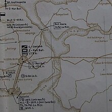
Cropped version of military map of
Zeeland, 1940. The Sloedam is the only connection between Walcheren and Zuid-Beveland, the area south of the Sloedam is already silted up.
279:
228:
24:
269:
121:
120:
attempted to stop the German invasion, but was unsuccessful. On 17 May a successful combat crossing of the
Sloedam was made by
149:
90:
338:
233:
166:(south of the Scheldt) and Zuid-Beveland (to the north) were freed from German control by Canadian forces. However,
318:
333:
141:
185:, the capture of Walcheren by amphibious troops landing on the west and southern parts of the island.
170:
island, north of the river mouth, still contained a large German force that controlled access to the
182:
145:
55:
Central
Zeeland in 1696. The Sloe is still a broad waterway separating Walcheren and Zuid-Beveland.
328:
163:
265:
117:
113:
107:
132:
112:
In May 1940, the area was contested during the German invasion of the Low
Countries in the
171:
155:
255:
Hoebekeke, R.E. Slagveld
Sloedam. Drukkerij Bareman, Terneuezen, 2002. ISBN 90-9015327-6
201:
312:
178:
154:
In 1944–1945, heavy fighting came to the area when the Allies attempted to clear the
79:
40:
36:
67:
23:
is 1 km long a dam, that was constructed in 1871, as a necessary part of the
75:
60:
294:
281:
167:
82:
in 1961, the
Sloedam lost it function as a primary defense against the sea.
51:
32:
59:
The Sloe was a waterway between the islands of
Walcheren near the town of
174:. De Sloedam was the only access road to the former island of Walcheren.
98:
During World War II, two battles were fought on and around the
Sloedam.
159:
71:
131:
89:
31:(Zealandic Line). Additionally this dam connected the island of
264:
Canadezen in actie. Henk Bollen en Paul
Vroemen; Terra 1992;
208:(in Dutch). Kon. Zeeuwsch Genootschap der Wetenschappen. 1982
39:
across the Sloe waterway, and therefore with the mainland of
116:. A combined French-Dutch force under brigadier-general
229:"Franse generaal moest zijn moed met de dood bekopen"
324:Buildings and structures in Middelburg, Zeeland
8:
74:with a second and a third Sloedam. When the
70:, the silted up areas south of the dam were
50:
193:
7:
177:The Canadians reached the dam from
14:
78:estuary was closed off by the
1:
25:Roosendaal-Vlissingen Railway
227:Cats, Jacques (3 May 2001).
158:, entrance to the harbor of
150:Battle of Walcheren Causeway
128:Battle of Walcheren Causeway
234:Provinciale Zeeuwse Courant
355:
139:
105:
206:Encyclopedie van Zeeland
162:. After heavy fighting,
136:The Sloedam bombed, 1944
122:SS Regiment Deutschland
137:
95:
56:
16:Dam in the Netherlands
142:Battle of the Scheldt
135:
93:
54:
291: /
183:Operation Infatuate
146:Operation Infatuate
339:History of Zeeland
164:Zeelandic Flanders
138:
96:
57:
118:Marcel Deslaurens
114:Battle of Zeeland
108:Battle of Zeeland
102:Battle of Zeeland
346:
306:
305:
303:
302:
301:
296:
295:51.500°N 3.700°E
292:
289:
288:
287:
284:
272:
262:
256:
253:
247:
246:
244:
242:
224:
218:
217:
215:
213:
198:
27:, the so-called
354:
353:
349:
348:
347:
345:
344:
343:
319:Dams in Zeeland
309:
308:
299:
297:
293:
290:
285:
282:
280:
278:
277:
275:
263:
259:
254:
250:
240:
238:
226:
225:
221:
211:
209:
200:
199:
195:
191:
172:Western Scheldt
156:Western Scheldt
152:
140:Main articles:
130:
110:
104:
88:
49:
17:
12:
11:
5:
352:
350:
342:
341:
336:
331:
326:
321:
311:
310:
274:
273:
257:
248:
219:
192:
190:
187:
129:
126:
106:Main article:
103:
100:
87:
84:
48:
45:
15:
13:
10:
9:
6:
4:
3:
2:
351:
340:
337:
335:
334:Zuid-Beveland
332:
330:
327:
325:
322:
320:
317:
316:
314:
307:
304:
300:51.500; 3.700
271:
270:90-6255-599-3
267:
261:
258:
252:
249:
236:
235:
230:
223:
220:
207:
203:
197:
194:
188:
186:
184:
180:
179:Zuid-Beveland
175:
173:
169:
165:
161:
157:
151:
147:
143:
134:
127:
125:
123:
119:
115:
109:
101:
99:
92:
85:
83:
81:
80:Veerse Gatdam
77:
73:
69:
64:
62:
53:
46:
44:
42:
38:
37:Zuid-Beveland
34:
30:
26:
22:
276:
260:
251:
239:. Retrieved
232:
222:
210:. Retrieved
205:
196:
176:
153:
111:
97:
86:World War II
68:World War II
65:
58:
29:Zeeuwse Lijn
28:
20:
18:
298: /
313:Categories
237:(in Dutch)
189:References
76:Veerse Gat
61:Arnemuiden
329:Walcheren
202:"SLOEDAM"
168:Walcheren
33:Walcheren
241:28 April
72:poldered
283:51°30′N
160:Antwerp
47:The dam
41:Brabant
21:Sloedam
286:3°42′E
268:
212:9 June
148:, and
66:After
35:with
266:ISBN
243:2017
214:2023
19:The
315::
231:.
204:.
144:,
124:.
43:.
245:.
216:.
Text is available under the Creative Commons Attribution-ShareAlike License. Additional terms may apply.