25:
347:
117:
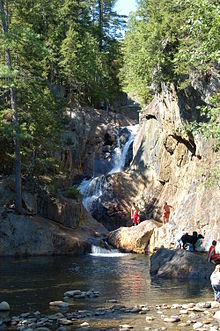
246:. It totals 54 feet (16 m) in height, and consists of (from top to bottom) a 12-foot slide/horsetail, a 25-foot segmented waterfall, a 14-foot horsetail, and a 3-foot cascade, separated by pools. A rest area on Maine Route 4 provides access to the falls; the rest area includes pit toilets, parking and picnic tables.
417:
412:
54:
156:
388:
318:
309:
94:
314:
427:
70:
407:
381:
239:
235:
149:
422:
46:
304:
374:
50:
134:
276:
263:
331:
288:
35:
39:
59:
74:
63:
358:
401:
243:
142:
346:
171:
158:
231:
227:
188:
116:
287:
Maine
Geological Survey, "Some Geological Features at Smalls Falls":
277:
http://www.newenglandwaterfalls.com/waterfall.php?name=Smalls%20Falls
332:
Maine
Geological Survey, "Some Geological Features at Smalls Falls"
354:
289:
http://www.maine.gov/doc/nrimc/mgs/explore/bedrock/sites/jul05.htm
138:
18:
57:
and tools are available to assist in formatting, such as
362:
213:
205:
197:
187:
148:
130:
109:
418:Tourist attractions in Franklin County, Maine
382:
8:
38:, which are uninformative and vulnerable to
53:and maintains a consistent citation style.
389:
375:
115:
106:
95:Learn how and when to remove this message
319:United States Department of the Interior
255:
7:
343:
341:
264:"Maine Geological Survey: Maine ACF"
413:Landforms of Franklin County, Maine
310:Geographic Names Information System
45:Please consider converting them to
14:
16:Waterfall in Maine, United States
345:
23:
315:United States Geological Survey
204:
196:
49:to ensure the article remains
1:
361:. You can help Knowledge by
357:state location article is a
240:West Central Franklin, Maine
444:
340:
334:. Retrieved May 27, 2010.
230:in Maine, is a series of
126:
114:
121:Smalls Falls, in Maine
428:Maine geography stubs
172:44.85860°N 70.51655°W
234:and cascades on the
408:Waterfalls of Maine
177:44.85860; -70.51655
168: /
423:Tiered waterfalls
370:
369:
221:
220:
105:
104:
97:
55:Several templates
435:
391:
384:
377:
349:
342:
328:
326:
325:
291:
285:
279:
274:
268:
267:
260:
183:
182:
180:
179:
178:
173:
169:
166:
165:
164:
161:
119:
107:
100:
93:
89:
86:
80:
78:
67:
27:
26:
19:
443:
442:
438:
437:
436:
434:
433:
432:
398:
397:
396:
395:
338:
323:
321:
303:
300:
295:
294:
286:
282:
275:
271:
262:
261:
257:
252:
238:in Township E,
206:Number of drops
176:
174:
170:
167:
162:
159:
157:
155:
154:
135:Franklin County
122:
101:
90:
84:
81:
69:
58:
44:
28:
24:
17:
12:
11:
5:
441:
439:
431:
430:
425:
420:
415:
410:
400:
399:
394:
393:
386:
379:
371:
368:
367:
350:
336:
335:
329:
305:"Smalls Falls"
299:
298:External links
296:
293:
292:
280:
269:
254:
253:
251:
248:
219:
218:
215:
211:
210:
207:
203:
202:
201:16.5 m (54 ft)
199:
195:
194:
191:
185:
184:
152:
146:
145:
132:
128:
127:
124:
123:
120:
112:
111:
103:
102:
47:full citations
31:
29:
22:
15:
13:
10:
9:
6:
4:
3:
2:
440:
429:
426:
424:
421:
419:
416:
414:
411:
409:
406:
405:
403:
392:
387:
385:
380:
378:
373:
372:
366:
364:
360:
356:
351:
348:
344:
339:
333:
330:
320:
316:
312:
311:
306:
302:
301:
297:
290:
284:
281:
278:
273:
270:
265:
259:
256:
249:
247:
245:
244:United States
241:
237:
233:
229:
225:
217:7.6 m (25 ft)
216:
212:
208:
200:
192:
190:
186:
181:
153:
151:
147:
144:
143:United States
140:
136:
133:
129:
125:
118:
113:
108:
99:
96:
88:
76:
75:documentation
72:
65:
64:documentation
61:
56:
52:
48:
43:
41:
37:
32:This article
30:
21:
20:
363:expanding it
352:
337:
322:. Retrieved
308:
283:
272:
258:
224:Smalls Falls
223:
222:
214:Longest drop
198:Total height
110:Smalls Falls
91:
82:
71:Citation bot
33:
236:Sandy River
175: /
150:Coordinates
85:August 2022
402:Categories
324:2009-04-14
232:waterfalls
163:70°31′00″W
160:44°51′31″N
51:verifiable
242:, in the
228:waterfall
36:bare URLs
131:Location
40:link rot
193:Tiered
60:reFill
355:Maine
353:This
250:Notes
139:Maine
34:uses
359:stub
226:, a
189:Type
68:and
404::
317:,
313:.
307:.
141:,
137:,
390:e
383:t
376:v
365:.
327:.
266:.
209:4
98:)
92:(
87:)
83:(
79:.
77:)
73:(
66:)
62:(
42:.
Text is available under the Creative Commons Attribution-ShareAlike License. Additional terms may apply.