29:
212:
The island is home to a variety of vegetation communities such as a small mangrove community, closed sclerophyll forest, closed vine forest and some coastal vegetation. It is inhabited by many sea creatures and birds including the pied imperial-pigeons who come here during the summer season.
197:(sea cucumbers) processing (boiling) may also have been undertaken here. There is evidence of remains of an early Chinese market garden on the island, the watercourse stonework of which is still visible today.
367:
357:
63:
362:
158:
162:
252:
181:
Aboriginal people. The Kuku
Yalanji people hunt and fish around the island and traditionally manage the island's culture.
201:
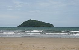
169:. Snapper Island is a popular tourism and sea kayaking destination. It is around 66 hectares or 0.66 square km in size.
295:
154:
51:
296:"Daintree River - Naming, Discovery & History of Daintree River & Snapper Island - Dan Irby"
193:
on the island, fired by wood from the
Daintree, ferried over on a vessel called the "Nellie".
325:
269:
142:
351:
194:
178:
230:
146:
130:
78:
65:
303:
190:
150:
118:
28:
326:"About | Snapper Island, Hope Islands National Park (CYPAL)"
270:"About | Snapper Island, Hope Islands National Park (CYPAL)"
177:
The island is part of the traditional sea country of the
126:
110:
102:
94:
57:
47:
42:
8:
167:Snapper Island National Park and Marine Park
21:
189:In the early 1900s, Jerry Doyle operated a
27:
20:
204:before he discovered the Daintree River.
153:, some 20 kilometres (12 miles) north of
332:. Queensland Government. 25 January 2006
276:. Queensland Government. 25 January 2006
159:Great Barrier Reef Marine Park Authority
231:"Snapper Island High Point, Queensland"
222:
368:National parks of Far North Queensland
163:Queensland Parks and Wildlife Service
7:
264:
262:
98:0.66 km (0.25 sq mi)
14:
358:Islands on the Great Barrier Reef
300:Daintree Cape Tribulation Tourism
141:is an island at the mouth of the
363:Islands of Far North Queensland
302:. 29 April 2006. Archived from
16:Island in Queensland, Australia
200:This island was a stopover by
1:
253:"Map of Snapper Island, QLD"
202:George Elphinstone Dalrymple
157:. It is administered by the
384:
115:
38:
26:
106:99 m (325 ft)
103:Highest elevation
52:Far North Queensland
75: /
23:
173:Indigenous culture
79:16.297°S 145.499°E
330:Parks and forests
274:Parks and forests
136:
135:
375:
342:
341:
339:
337:
322:
316:
315:
313:
311:
306:on 29 April 2006
292:
286:
285:
283:
281:
266:
257:
256:
249:
243:
242:
240:
238:
233:. peakbagger.com
227:
90:
89:
87:
86:
85:
84:-16.297; 145.499
80:
76:
73:
72:
71:
68:
31:
24:
383:
382:
378:
377:
376:
374:
373:
372:
348:
347:
346:
345:
335:
333:
324:
323:
319:
309:
307:
294:
293:
289:
279:
277:
268:
267:
260:
251:
250:
246:
236:
234:
229:
228:
224:
219:
210:
208:Flora and Fauna
187:
175:
122:
83:
81:
77:
74:
69:
66:
64:
62:
61:
34:
17:
12:
11:
5:
381:
379:
371:
370:
365:
360:
350:
349:
344:
343:
317:
287:
258:
244:
221:
220:
218:
215:
209:
206:
186:
183:
174:
171:
143:Daintree River
139:Snapper Island
134:
133:
128:
124:
123:
116:
113:
112:
111:Administration
108:
107:
104:
100:
99:
96:
92:
91:
59:
55:
54:
49:
45:
44:
40:
39:
36:
35:
33:Snapper Island
32:
22:Snapper Island
15:
13:
10:
9:
6:
4:
3:
2:
380:
369:
366:
364:
361:
359:
356:
355:
353:
331:
327:
321:
318:
305:
301:
297:
291:
288:
275:
271:
265:
263:
259:
254:
248:
245:
232:
226:
223:
216:
214:
207:
205:
203:
198:
196:
192:
185:Other history
184:
182:
180:
172:
170:
168:
164:
160:
156:
152:
148:
144:
140:
132:
129:
125:
121:
120:
114:
109:
105:
101:
97:
93:
88:
60:
56:
53:
50:
46:
41:
37:
30:
25:
19:
334:. Retrieved
329:
320:
308:. Retrieved
304:the original
299:
290:
278:. Retrieved
273:
247:
235:. Retrieved
225:
211:
199:
195:Beche-de-mer
188:
179:Kuku Yalanji
176:
166:
155:Port Douglas
138:
137:
117:
18:
82: /
70:145°29′56″E
58:Coordinates
352:Categories
237:3 November
217:References
147:Queensland
131:Queensland
67:16°17′49″S
191:lime kiln
151:Australia
119:Australia
43:Geography
161:and the
48:Location
336:11 June
310:11 June
280:11 June
165:as the
127:State
338:2023
312:2023
282:2023
239:2022
95:Area
145:in
354::
328:.
298:.
272:.
261:^
149:,
340:.
314:.
284:.
255:.
241:.
Text is available under the Creative Commons Attribution-ShareAlike License. Additional terms may apply.