45:
65:
350:
340:
72:
330:
199:, the Spanish National Institute for Forestal recovery that had bought the land surrounding the villages. There were other factors as well, such as the abandonment of traditional agricultural practices like
44:
472:
408:
64:
93:
482:
394:
195:
There were many villages in Solana Valley. The inhabitants left the place between 1960 and 1970 owing to the pressure induced by
477:
467:
255:
in Muro de Solana, Santiago Church in
Villamana and Saint Peter's Church in Gere. Many of the churches are in ruins.
462:
349:
213:
184:
405:
243:
In Solana Valley there are numerous village churches and smaller religious buildings, such as the
297:
165:
423:
437:
318:
487:
390:
50:
263:
258:
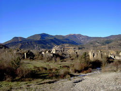
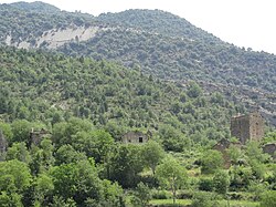
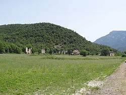
The villages in the valley lie abandoned and the houses have fallen into disrepair and ruin:
158:
412:
232:
221:
208:
35:
456:
367:
248:
447:
286:
108:
95:
339:
207:
rearing, as well as the lifestyle changes that swept over rural Spain after
187:
cuts across the valley from east to west and its average altitude is 850 m.
442:
225:
172:
228:
329:
176:
138:
424:
Diario del AltoAragón (10 d'agost del 2009) - El valle de La Solana
200:
196:
180:
128:
220:
Most of Solana Valley's territory depends administratively from
204:
217:
that pulled the local youth towards the cities and the coast.
144:
134:
124:
21:
353:Frescoes decaying in a ruined church of the valley
312:San Martín de Puytarans or San Martín de la Solana
315:Sanfelices de Solana or Sanfelices de la Ribera
8:
18:
387:Jánovas, víctimas de un pantano de papel.
443:Picture of Janovas - Vallée de la Solana
348:
338:
328:
378:
143:
123:
88:
57:
41:
133:
71:
7:
473:Geography of the Province of Huesca
14:
389:Pirineum Editorial, Jaca, 2006.
70:
63:
43:
16:Natural region in Aragon, Spain
333:Abandoned houses in Lavelilla.
1:
49:View of Jánovas, one of the
504:
326:
148:850 m (2,790 ft)
385:Menjón Ruiz, Marisancho,
89:
58:
42:
33:
483:Natural regions of Spain
448:Pictures of the villages
406:Despoblación en Aragon
354:
344:
334:
253:Iglesia de Santa María
245:Iglesia de la Asunción
214:Plan de Estabilización
352:
342:
332:
171:) is a valley in the
53:in the Solana Valley.
478:Ghost towns in Spain
109:42.49583°N 0.02500°W
468:Landforms of Aragon
438:Pirinei - La Solana
175:. It is located in
105: /
411:2012-08-23 at the
355:
345:
335:
166:Aragonese language
162:Valle de la Solana
114:42.49583; -0.02500
51:abandoned villages
27:Valle de la Solana
359:
358:
300:or Muro de Solana
152:
151:
495:
463:Valleys of Spain
426:
421:
415:
403:
397:
383:
325:
324:
251:in Burgasé, the
159:Spanish language
120:
119:
117:
116:
115:
110:
106:
103:
102:
101:
98:
74:
73:
67:
47:
19:
503:
502:
498:
497:
496:
494:
493:
492:
453:
452:
434:
429:
422:
418:
413:Wayback Machine
404:
400:
384:
380:
376:
364:
343:View of Lacort.
323:
241:
233:Huesca Province
193:
113:
111:
107:
104:
99:
96:
94:
92:
91:
85:
84:
83:
82:
81:
80:
79:
75:
54:
38:
29:
24:
17:
12:
11:
5:
501:
499:
491:
490:
485:
480:
475:
470:
465:
455:
454:
451:
450:
445:
440:
433:
432:External links
430:
428:
427:
416:
398:
377:
375:
372:
371:
370:
363:
360:
357:
356:
346:
336:
322:
321:
316:
313:
310:
307:
304:
301:
295:
292:
289:
284:
281:
278:
275:
272:
269:
266:
260:
240:
237:
209:General Franco
192:
189:
169:Val d'a Solana
150:
149:
146:
142:
141:
136:
132:
131:
126:
122:
121:
87:
86:
77:
76:
69:
68:
62:
61:
60:
59:
56:
55:
48:
40:
39:
36:Natural region
34:
31:
30:
25:
22:
15:
13:
10:
9:
6:
4:
3:
2:
500:
489:
486:
484:
481:
479:
476:
474:
471:
469:
466:
464:
461:
460:
458:
449:
446:
444:
441:
439:
436:
435:
431:
425:
420:
417:
414:
410:
407:
402:
399:
396:
395:84-935061-0-9
392:
388:
382:
379:
373:
369:
368:Exconjuratory
366:
365:
361:
351:
347:
341:
337:
331:
327:
320:
317:
314:
311:
308:
305:
302:
299:
296:
293:
290:
288:
285:
282:
279:
276:
273:
270:
267:
265:
262:
261:
259:
256:
254:
250:
249:exconjuratory
246:
238:
236:
234:
230:
227:
223:
218:
216:
215:
210:
206:
202:
198:
190:
188:
186:
182:
178:
174:
170:
167:
163:
160:
156:
155:Solana Valley
147:
140:
137:
130:
127:
118:
90:Coordinates:
78:Solana Valley
66:
52:
46:
37:
32:
28:
23:Solana Valley
20:
419:
401:
386:
381:
257:
252:
244:
242:
219:
212:
194:
168:
161:
154:
153:
26:
298:Muro de Ara
239:Ghost towns
112: /
457:Categories
374:References
97:42°29′45″N
319:Villamana
294:Lavelilla
274:Castellar
185:River Ara
145:Elevation
488:Pyrenees
409:Archived
362:See also
280:Ginuabel
247:and the
226:Sobrarbe
173:Pyrenees
100:0°1′30″W
309:Semolué
303:Puyuelo
287:Jánovas
264:Burgasé
229:comarca
191:History
125:Country
393:
291:Lacort
271:Càmpol
222:Fiscal
177:Aragon
139:Aragon
135:Region
283:Giral
268:Càjol
201:sheep
197:ICONA
181:Spain
129:Spain
391:ISBN
306:Sasé
277:Gere
205:goat
203:and
211:'s
459::
235:.
231:,
224:,
183:.
179:,
164:;
157:(
Text is available under the Creative Commons Attribution-ShareAlike License. Additional terms may apply.