57:
402:
shoreline for stints of a few months. Castaways would occasionally end up on the islands, and in 1813, a passing ship bound for
Stewart Island found five men in need of rescue. The men – four Europeans and one Australian Aboriginal – were marooned there between 1808 and 1813, representing the longest continuous period of habitation on the islands. They are thought to have been left ashore in two groups for seal hunting (sealing), but the sea prevented the approach of any ship to recover them. In 1810, sealing moved to
1274:
346:
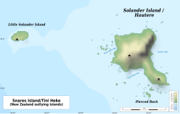
322:), the main island, covers around 1 km (0.39 sq mi), rising steeply to a peak 330 metres (1,083 ft) above sea level. It is wooded except for its northeast end, mainly a bare, white rock. A deep cave is on the east side, Sealers Cave. Little Solander Island is 1.9 km (1.2 mi) west. It reaches 148 m (486 ft) high yet covers 4 ha (9.9 acres). It has a barren appearance and is
1256:
1336:
568:
1289:
1007:
Foley, Fiona V.; Turner, Simon; Rushmer, Tracy
Rushmer; Caulfield, John T.; Daczko, Nathan R.; Bierman, Paul; Robertson, Matthew; Barrie, Craig D.; Boyce, Adrian J. (2014). "Be, O and radiogenic isotopic constraints on the origin of adakitic signatures: a case study from Solander and Little Solander
433:
dome of Little
Solander Island was active between 20 and 50,000 years ago. The age of the main island is 150 to 400 thousand years old, backed up by pollen data, with in one set of analysis the eruptives having a mean age of 344 ± 10 ka and another mean age of 247 ± 8 ka. The islands lie on a bank
401:
The islands are geographically forbidding and weather conditions often confound the approach of ships, dissuading attempts at permanent habitation. Australian sealers briefly made use of the islands during the early 19th century, likely living on small flats between the island's cliffs and its
481:
sediment. This is isotopically distinct continental crust from the
Solander Islands, excluding partial melting of the lower crust as creating the volcanic magma. It has been suggested that the melt that formed the islands comes from a
298:
of rock samples from the main island found that it was between 150,000 and 400,000 years old. In 2013 it was discovered that Little
Solander Island had been active even more recently at between 20 and 50,000 years ago.
1224:
902:
1470:
438:
along
Foveaux Strait by a 4 km (2.5 mi) but narrow trough 200 m (656 ft) deep (at least 237 m or 778 ft). Therefore, the islands are included in the
1217:
326:-covered. Pierced Rock is 250 m (273 yd) south of the main island. It rises to 54 m (177 ft) and covers 2,000 m (22,000 sq ft) (0.2 ha).
1505:
1099:
778:
Mortimer, N.; Gans, P.B.; Foley, F. V.; Turner, M. B.; Daczko, N.; Robertson, M.; Turnbull, I. M. (2013). "Geology and Age of
Solander Volcano, Fiordland, New Zealand".
1210:
886:
Beattie, J.H (1944). "Māori place-names of Otago: hundreds of hitherto unpublished names with numerous authentic traditions / told by the Maoris to
Herries Beattie".
1436:
1485:
1495:
1233:
1490:
1460:
1197:
1165:
1043:
1510:
821:
406:, farther to the west, and they were effectively abandoned. When rediscovered in 1813, it is likely that they had amassed many dried seal pelts.
1369:
1188:
1465:
1328:
1180:
31:
941:
1431:
1324:
1475:
586:
98:
1374:
933:
Murihiku: A History of the South Island of New
Zealand and the Islands Adjacent and Lying to the South, from 1642 to 1835
1410:
581:
439:
334:
307:
56:
869:
The Maoris and
Fiordland: Māori myths, fascinating fables, legendary lore, typical traditions and native nomenclature
748:
1480:
515:
971:"Magmatic Evolution and Magma Mixing of Quaternary Adakites at Solander and Little Solander Islands, New Zealand"
1378:
1361:
931:
1500:
1302:
625:"A middle-late Quaternary age for the adakitic arc volcanics of Hautere (Solander Island), Southern Ocean"
545:
275:
just beyond New Zealand's South Island. The islands lie 40 km (25 mi) south of the coastline of
70:
Map of the undersea Solander arc volcano edifice (brown). Clicking on the map enables panning and zooming.
1202:
549:
350:
624:
1424:
1237:
787:
636:
553:
522:
1387:
1185:
1060:
541:
345:
1137:
BirdLife International. (2012). Important Bird Areas factsheet: Solander Islands. Downloaded from
1121:
294:. It was formerly believed that the volcano last erupted roughly 2 million years ago, but in 2008
1025:
803:
498:
There are 53 vascular plant species, one third of which are very rare. The flora is dominated by
330:
303:
295:
86:
445:
The islands are the only volcanic land in New Zealand recently related to the subduction of the
1391:
970:
937:
872:
849:
723:
652:
435:
394:
46:
1092:
Sperm whaling on the Solanders Grounds and in Fiordland: A marine historian's perspective
1418:
1320:
1103:
1017:
982:
795:
679:
644:
446:
403:
374:
370:
1383:
1347:
1313:
1192:
864:
591:
521:
The Solander Islands were historically a well-known area for migrating whales, especially
461:. The current estimated rate of subduction is 35–36 mm per year. The Solander Basin
454:
389:
791:
640:
969:
Foley, Fiona V.; Pearson, Norman J.; Rushmer, Tracy; Turner, Simon; Adam, John (2013).
573:
415:
291:
272:
1090:
1454:
1086:
1029:
807:
648:
596:
487:
450:
287:
211:
1175:
670:
Mortimer, N. (2013). "Geology and Age of Solander Volcano, Fiordland, New Zealand".
1354:
1279:
486:
source enriched by the addition of a slab-derived melt with subsequent open-system
458:
255:
30:"Solander Island" redirects here. For the island off the west coast of Canada, see
1261:
526:
422:
186:
174:
1170:
987:
697:
17:
1021:
563:
507:
483:
385:
231:
196:
656:
113:
100:
1107:
567:
474:
276:
236:
180:
478:
462:
430:
419:
283:
226:
221:
206:
201:
191:
822:"Te Ara-a-Kiwa: How Foveaux Strait came to be according to Māori legend"
1404:
These combine the regional and the territorial authority levels in one
1341:
466:
426:
268:
241:
216:
1122:"Birds and mammals of Solander (Hautere) Island." Notornis 27: 21-44"
847:
Roberts, W.H.S (1910). "Maori Nomenclature: Early history of Otago".
503:
470:
936:. Cambridge University Press (republished 2011). pp. 208–211.
799:
683:
434:
with depths less than 100 m (328 ft), separated from the
903:"Science on the Map: Places in New Zealand Named After Scientists"
344:
323:
529:. Sperm whales in this area were said to be exceptionally large.
1294:
499:
425:
volcano whose volcanics have geochemical affinities with modern
1206:
722:
Lewis, Keith; Nodder, Scott D.; Carter, Lionel (12 June 2006).
388:
on 11 March 1770 and named by him after the Swedish naturalist
1138:
1152:(4th ed.) (1969) Dunedin: H. Wise & Co. (N.Z.) Ltd.
1050:. Updated 21 September 2007. Retrieved 29 March 2009.
702:
Smithsonian Institute | Global Volcanism Program
1150:
Wise's New Zealand guide: A gazetteer of New Zealand
1100:
National Institute of Water and Atmospheric Research
357:
The Māori name for the summit of Solander Island is
623:Mortimer, N.; Gans, P.B.; Mildenhall, D.C. (2008).
548:because of its significance as a breeding site for
167:
153:
145:
137:
129:
92:
82:
77:
44:
361:, and the side of the summit is known in Māori as
318:Solander Island / Hautere (also known in Māori as
1042:Keith Lewis, Scott D. Nodder and Lionel Carter. '
392:, one of the scientific crew aboard Cook's ship,
537:The islands are home to a variety of bird life.
414:The islands are remnants of an isolated extinct
337:of New Zealand to be part of a local authority.
310:of New Zealand to be part of a local authority.
27:Three islets off the South Island of New Zealand
457:, which extends southwards from the end of the
773:
771:
769:
629:Journal of Volcanology and Geothermal Research
618:
616:
614:
612:
490:, resulted in the evolved andesitic adakites.
1471:Volcanoes of the New Zealand outlying islands
1413:outside any regional authority (the outlying
1218:
724:"Sea floor geology - Active plate boundaries"
540:The Solander group has been identified as an
8:
1401:Seven districts lie in more than one region
1002:
1000:
998:
964:
962:
960:
286:rocks with the tip being a larger submerged
271:islets towards the western enterance of the
39:
1506:Islands of the New Zealand outlying islands
925:
923:
329:Administratively, the islands form part of
302:Administratively, the islands form part of
1225:
1211:
1203:
55:
38:
1067:. Department of Geology, Otago University
1010:Contributions to Mineralogy and Petrology
986:
698:"Global Volcanism Program | Hautere"
1246:
1048:Te Ara – the Encyclopedia of New Zealand
728:Te Ara - the Encyclopedia of New Zealand
384:The island chain was sighted by Captain
608:
514:) breeds only on the Solanders and the
349:View of the Solander Islands, drawn by
749:"Solander Island – an extinct volcano"
465:continental basement rock consists of
7:
1127:. Notornis vol. 27). pp. 21–44.
1486:Important Bird Areas of New Zealand
1044:Sea floor geology – Solander Island
890:. Dunedin, New Zealand. p. 76.
853:. Dunedin, New Zealand. p. 40.
333:, making them the only uninhabited
306:, making them the only uninhabited
1496:Uninhabited islands of New Zealand
32:Solander Island Ecological Reserve
25:
1329:Manawatāwhi / Three Kings Islands
1334:
1287:
1272:
1254:
649:10.1016/j.jvolgeores.2008.09.003
566:
290:, roughly equivalent in size to
1491:Volcanic islands of New Zealand
1461:Islands of the Southland Region
506:. The southern, and nominate,
1511:Stratovolcanoes of New Zealand
1407:Special territorial authority
587:List of islands of New Zealand
373:chief, who notably murdered a
1:
365:. "Hautere" is the father of
1466:New Zealand outlying islands
1425:Non-self-governing territory
1411:New Zealand outlying islands
582:New Zealand outlying islands
552:(with about 5000 pairs) and
440:New Zealand Outlying Islands
61:Map of the Solander Islands
1527:
1437:States in free association
267:are three eroded remnants
265:Solander Islands / Hautere
141:1.6 km (0.99 mi)
40:Solander Islands / Hautere
29:
1435:
1409:
1359:
1352:
1345:
1332:
1319:
1317:
1312:
1284:
1269:
1267:
1265:
1252:
1244:
1022:10.1007/s00410-014-1048-9
172:
158:
149:330 m (1080 ft)
66:
54:
1234:Administrative divisions
988:10.1093/petrology/egs082
871:. Dunedin, New Zealand:
1370:Territorial authorities
1325:NZ Subantarctic Islands
1307:11 non-unitary regions
1139:http://www.birdlife.org
1008:Islands, New Zealand".
512:Thalassarche b. bulleri
510:of Buller's albatross (
133:120 ha (300 acres)
1120:O'Donnell, Colin F.J.
930:McNab, Robert (1905).
907:The Rutherford Journal
546:BirdLife International
354:
353:on HMB Endeavour, 1770
168:Additional information
146:Highest elevation
1476:Pleistocene volcanoes
554:common diving petrels
348:
335:outlying island group
308:outlying island group
1432:Antarctic dependency
1238:Realm of New Zealand
1181:Nautical information
975:Journal of Petrology
753:Science Learning Hub
550:Buller's albatrosses
1417:form a part of the
1384:1 metropolitan area
1191:11 May 2009 at the
1176:Fauna (Albatrosses)
1141:on 27 January 2012.
828:. 21 September 2021
826:The Southland Times
792:2013JG....121..475M
641:2008JVGR..178..701M
542:Important Bird Area
110: /
41:
1310:5 unitary regions
780:Journal of Geology
672:Journal of Geology
355:
331:Southland District
304:Southland District
296:radiometric dating
114:46.567°S 166.883°E
87:Southland District
1481:Extinct volcanoes
1448:
1447:
1443:
1442:
1439:with New Zealand
888:Otago Daily Times
873:Otago Daily Times
850:Otago Daily Times
436:continental shelf
261:
260:
16:(Redirected from
1518:
1419:Southland Region
1415:Solander Islands
1364:
1357:
1340:
1338:
1337:
1321:Kermadec Islands
1297:
1293:
1291:
1290:
1282:
1278:
1276:
1275:
1260:
1258:
1257:
1247:
1227:
1220:
1213:
1204:
1142:
1135:
1129:
1128:
1126:
1117:
1111:
1110:
1097:
1083:
1077:
1076:
1074:
1072:
1057:
1051:
1040:
1034:
1033:
1004:
993:
992:
990:
966:
955:
954:
952:
950:
927:
918:
917:
915:
913:
898:
892:
891:
883:
877:
876:
861:
855:
854:
844:
838:
837:
835:
833:
818:
812:
811:
775:
764:
763:
761:
759:
745:
739:
738:
736:
734:
719:
713:
712:
710:
708:
694:
688:
687:
667:
661:
660:
620:
576:
571:
570:
469:and subordinate
447:Australian Plate
404:Macquarie Island
282:The islands are
253:
183:
125:
124:
122:
121:
120:
119:-46.567; 166.883
115:
111:
108:
107:
106:
103:
59:
42:
21:
1526:
1525:
1521:
1520:
1519:
1517:
1516:
1515:
1451:
1450:
1449:
1444:
1427:of New Zealand
1360:
1353:
1348:Ross Dependency
1335:
1333:
1327:
1323:
1314:Chatham Islands
1288:
1286:
1285:
1273:
1271:
1270:
1255:
1253:
1240:
1231:
1193:Wayback Machine
1162:
1156:
1146:
1145:
1136:
1132:
1124:
1119:
1118:
1114:
1095:
1085:
1084:
1080:
1070:
1068:
1065:www.otago.ac.nz
1059:
1058:
1054:
1041:
1037:
1006:
1005:
996:
968:
967:
958:
948:
946:
944:
929:
928:
921:
911:
909:
900:
899:
895:
885:
884:
880:
863:
862:
858:
846:
845:
841:
831:
829:
820:
819:
815:
777:
776:
767:
757:
755:
747:
746:
742:
732:
730:
721:
720:
716:
706:
704:
696:
695:
691:
669:
668:
664:
622:
621:
610:
605:
592:List of islands
572:
565:
562:
535:
496:
494:Flora and fauna
455:Puysegur Trench
412:
390:Daniel Solander
343:
316:
254:
252:
251:
250:
249:
244:
239:
234:
229:
224:
219:
214:
209:
204:
199:
194:
189:
178:
177:
163:
118:
116:
112:
109:
104:
101:
99:
97:
96:
73:
72:
71:
62:
50:
35:
28:
23:
22:
18:Solander Island
15:
12:
11:
5:
1524:
1522:
1514:
1513:
1508:
1503:
1501:Foveaux Strait
1498:
1493:
1488:
1483:
1478:
1473:
1468:
1463:
1453:
1452:
1446:
1445:
1441:
1440:
1434:
1430:New Zealand's
1428:
1422:
1408:
1405:
1402:
1399:
1395:
1394:
1381:
1372:
1366:
1365:
1358:
1351:
1344:
1331:
1318:
1316:
1311:
1308:
1305:
1299:
1298:
1283:
1268:
1266:
1264:
1251:
1245:
1242:
1241:
1232:
1230:
1229:
1222:
1215:
1207:
1201:
1200:
1195:
1183:
1178:
1173:
1168:
1161:
1160:External links
1158:
1154:
1153:
1144:
1143:
1130:
1112:
1078:
1061:"Alpine Fault"
1052:
1035:
994:
981:(4): 703–744.
956:
942:
919:
901:Lee, Garry J.
893:
878:
856:
839:
813:
800:10.1086/671397
786:(5): 475–487.
765:
740:
714:
689:
684:10.1086/671397
662:
635:(4): 701–707.
607:
606:
604:
601:
600:
599:
594:
589:
584:
578:
577:
574:Islands portal
561:
558:
534:
531:
523:southern right
495:
492:
416:trachyandesite
411:
408:
351:Herman Spöring
342:
339:
320:Te Niho a Kewa
315:
312:
292:Mount Taranaki
273:Foveaux Strait
259:
258:
247:
246:
245:
240:
235:
230:
225:
220:
215:
210:
205:
200:
195:
190:
185:
184:
179:0.4–0.15
170:
169:
165:
164:
159:
156:
155:
154:Administration
151:
150:
147:
143:
142:
139:
135:
134:
131:
127:
126:
94:
90:
89:
84:
80:
79:
75:
74:
69:
68:
67:
64:
63:
60:
52:
51:
45:
26:
24:
14:
13:
10:
9:
6:
4:
3:
2:
1523:
1512:
1509:
1507:
1504:
1502:
1499:
1497:
1494:
1492:
1489:
1487:
1484:
1482:
1479:
1477:
1474:
1472:
1469:
1467:
1464:
1462:
1459:
1458:
1456:
1438:
1433:
1429:
1426:
1423:
1420:
1416:
1412:
1406:
1403:
1400:
1397:
1396:
1393:
1389:
1385:
1382:
1380:
1376:
1373:
1371:
1368:
1367:
1363:
1356:
1350:
1349:
1343:
1330:
1326:
1322:
1315:
1309:
1306:
1304:
1301:
1300:
1296:
1281:
1263:
1249:
1248:
1243:
1239:
1235:
1228:
1223:
1221:
1216:
1214:
1209:
1208:
1205:
1199:
1196:
1194:
1190:
1187:
1186:NZ map viewer
1184:
1182:
1179:
1177:
1174:
1172:
1169:
1167:
1164:
1163:
1159:
1157:
1151:
1148:
1147:
1140:
1134:
1131:
1123:
1116:
1113:
1109:
1105:
1101:
1094:
1093:
1088:
1087:Rhys Richards
1082:
1079:
1066:
1062:
1056:
1053:
1049:
1045:
1039:
1036:
1031:
1027:
1023:
1019:
1015:
1011:
1003:
1001:
999:
995:
989:
984:
980:
976:
972:
965:
963:
961:
957:
945:
943:9781108039994
939:
935:
934:
926:
924:
920:
908:
904:
897:
894:
889:
882:
879:
875:. p. 19.
874:
870:
866:
860:
857:
852:
851:
843:
840:
827:
823:
817:
814:
809:
805:
801:
797:
793:
789:
785:
781:
774:
772:
770:
766:
754:
750:
744:
741:
729:
725:
718:
715:
703:
699:
693:
690:
685:
681:
677:
673:
666:
663:
658:
654:
650:
646:
642:
638:
634:
630:
626:
619:
617:
615:
613:
609:
602:
598:
597:Desert island
595:
593:
590:
588:
585:
583:
580:
579:
575:
569:
564:
559:
557:
555:
551:
547:
543:
538:
532:
530:
528:
524:
519:
517:
513:
509:
505:
501:
493:
491:
489:
488:fractionation
485:
480:
476:
472:
468:
464:
460:
456:
452:
451:Pacific Plate
448:
443:
441:
437:
432:
428:
424:
421:
417:
409:
407:
405:
399:
397:
396:
391:
387:
382:
380:
377:chief called
376:
372:
368:
364:
360:
352:
347:
340:
338:
336:
332:
327:
325:
321:
313:
311:
309:
305:
300:
297:
293:
289:
288:stratovolcano
285:
280:
278:
274:
270:
266:
257:
243:
238:
233:
228:
223:
218:
213:
208:
203:
198:
193:
188:
182:
176:
171:
166:
162:
157:
152:
148:
144:
140:
136:
132:
128:
123:
95:
91:
88:
85:
81:
76:
65:
58:
53:
48:
43:
37:
33:
19:
1414:
1379:50 districts
1346:
1280:Cook Islands
1155:
1149:
1133:
1115:
1091:
1081:
1069:. Retrieved
1064:
1055:
1047:
1038:
1013:
1009:
978:
974:
947:. Retrieved
932:
910:. Retrieved
906:
896:
887:
881:
868:
865:Beattie, J.H
859:
848:
842:
830:. Retrieved
825:
816:
783:
779:
756:. Retrieved
752:
743:
731:. Retrieved
727:
717:
707:10 September
705:. Retrieved
701:
692:
675:
671:
665:
632:
628:
539:
536:
527:sperm whales
520:
511:
497:
473:overlaid by
459:Alpine Fault
449:beneath the
444:
413:
400:
393:
383:
378:
366:
362:
358:
356:
328:
319:
317:
301:
281:
264:
262:
160:
36:
1392:3 districts
1362:14 villages
1262:New Zealand
758:19 February
678:: 475–487.
484:peridotitic
423:Pleistocene
379:Tūtewaimate
256:Arc volcano
175:Pleistocene
161:New Zealand
117: /
93:Coordinates
1455:Categories
1355:15 islands
1250:Countries
1108:Q125945903
603:References
508:subspecies
453:along the
386:James Cook
375:Kāti Māmoe
371:Ngāti Kurī
1375:11 cities
1071:18 August
1030:129879486
808:140662244
657:0377-0273
544:(IBA) by
533:Bird life
475:Oligocene
395:Endeavour
277:Fiordland
78:Geography
49:: Hautere
1189:Archived
1104:Wikidata
1089:(2010),
1016:(1048).
949:21 March
912:20 April
867:(1949).
560:See also
479:Pliocene
463:Mesozoic
431:andestic
427:adakites
420:andesite
363:Pukepari
359:Pukekohu
284:andesite
269:volcanic
105:166°53′E
83:Location
1342:Tokelau
1303:Regions
1236:of the
1166:Geology
788:Bibcode
637:Bibcode
504:orchids
467:diorite
410:Geology
341:History
314:Islands
248:↓
102:46°34′S
1398:Notes
1390:, and
1388:1 city
1339:
1292:
1277:
1259:
1171:Botany
1106:
1028:
940:
832:16 May
806:
733:16 May
655:
516:Snares
471:gabbro
429:. The
138:Length
1198:photo
1125:(PDF)
1096:(PDF)
1026:S2CID
804:S2CID
500:ferns
324:guano
47:Māori
1377:and
1295:Niue
1073:2022
951:2019
938:ISBN
914:2019
834:2024
760:2022
735:2024
709:2024
653:ISSN
525:and
502:and
418:and
369:, a
367:Moko
263:The
187:PreꞒ
173:Age
130:Area
1046:',
1018:doi
1014:168
983:doi
796:doi
784:121
680:doi
645:doi
633:178
477:to
1457::
1421:)
1386:,
1102:,
1098:,
1063:.
1024:.
1012:.
997:^
979:54
977:.
973:.
959:^
922:^
905:.
824:.
802:.
794:.
782:.
768:^
751:.
726:.
700:.
674:.
651:.
643:.
631:.
627:.
611:^
556:.
518:.
442:.
398:.
381:.
279:.
237:Pg
181:Ma
1226:e
1219:t
1212:v
1075:.
1032:.
1020::
991:.
985::
953:.
916:.
836:.
810:.
798::
790::
762:.
737:.
711:.
686:.
682::
676:5
659:.
647::
639::
242:N
232:K
227:J
222:T
217:P
212:C
207:D
202:S
197:O
192:Ꞓ
34:.
20:)
Text is available under the Creative Commons Attribution-ShareAlike License. Additional terms may apply.