674:
668:
656:
1390:
662:
291:
516:
650:
29:
250:
Constructed between 1970 and 1974, the dam replaced the earlier
Strawberry Dam, built slightly upstream of the current site from 1911 to 1913. The new dam increased the storage capacity of Strawberry Reservoir from 283,000 acre-feet (0.349 km) to more than 1,120,000 acre-feet (1.38 km). The
274:
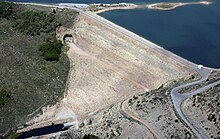
Soldier Creek Dam is a zoned earthfill embankment 272 feet (83 m) high and 1,290 feet (390 m) long, with a structural volume of 3,206,000 cubic yards (2,451,000 m). Water releases from the dam are controlled by
1455:
1460:
1354:
1470:
547:
1349:
1359:
1028:
982:
909:
1006:
987:
279:
with a bypass capacity of 2,830 cu ft/s (80 m/s). The dam controls runoff from a drainage area of 170 square miles (440 km).
952:
483:
874:
1291:
1431:
1364:
540:
491:
436:
402:
304:
244:
59:
392:
1329:
1301:
251:
primary purpose of the dam is to store flows from the upper
Strawberry River, as well as water diverted from eight tributaries of the
1236:
894:
330:
1475:
775:
1241:
533:
1306:
804:
780:
520:
1286:
844:
1296:
1281:
1051:
110:
1276:
1465:
829:
360:
1424:
1200:
1190:
1162:
1122:
942:
212:
135:
425:
1334:
1231:
937:
260:
1450:
1323:
967:
917:
824:
216:
1081:
1271:
1117:
1096:
1056:
889:
814:
397:
264:
240:
236:
174:
39:
1480:
1127:
1046:
1036:
368:
1417:
1369:
1205:
1195:
1157:
977:
899:
239:
and is a principal feature of the
Strawberry Valley Project, part of the Bonneville Unit of the
922:
859:
1401:
1246:
819:
719:
1215:
1167:
1061:
932:
884:
864:
809:
724:
706:
701:
629:
1344:
1086:
1001:
957:
834:
785:
556:
252:
220:
189:
458:
1444:
991:
927:
854:
849:
839:
743:
47:
1339:
1251:
1091:
996:
737:
688:
673:
276:
259:. Water from the Strawberry Tunnel eventually outlets into Sixth Water Canyon, the
667:
655:
255:, for diversion through the Strawberry Tunnel to supplement water supplies in the
1210:
1185:
1152:
1147:
1137:
1132:
1101:
1011:
972:
962:
869:
732:
714:
693:
296:
256:
661:
1076:
1066:
1041:
947:
879:
603:
582:
286:
28:
74:
61:
1142:
1071:
268:
1389:
515:
589:
649:
525:
617:
575:
636:
596:
1397:
610:
224:
43:
529:
122:
1456:
Dams in the Green River (Colorado River tributary) basin
1405:
243:. The dam and reservoir were built and operated by the
1315:
1264:
1224:
1176:
1110:
1027:
1020:
908:
797:
681:
564:
198:
188:
180:
170:
165:
157:
149:
141:
131:
121:
116:
106:
98:
90:
53:
35:
21:
1355:Metropolitan Water District of Southern California
1461:Buildings and structures in Wasatch County, Utah
484:"Soldier Creek Dam Hydraulics & Hydrology"
1425:
541:
8:
325:
323:
321:
319:
1350:International Boundary and Water Commission
1432:
1418:
1024:
548:
534:
526:
27:
18:
387:
385:
1471:United States Bureau of Reclamation dams
393:"Central Utah Project - Bonneville Unit"
337:. U.S. Bureau of Reclamation. 2009-04-08
184:1,127,610 acre⋅ft (1.39089 km)
315:
426:"Central Utah Project Bonneville Unit"
355:
353:
351:
7:
1386:
1384:
1292:Glen Canyon National Recreation Area
488:Central Utah Project–Bonneville Unit
365:National Performance of Dams Program
335:Central Utah Project–Bonneville Unit
492:United States Bureau of Reclamation
437:United States Bureau of Reclamation
403:United States Bureau of Reclamation
305:List of dams and reservoirs in Utah
245:United States Bureau of Reclamation
1404:. You can help Knowledge (XXG) by
1330:Colorado River Board of California
1302:Lake Mead National Recreation Area
433:Historic Reclamation Projects Book
14:
194:170 sq mi (440 km)
1388:
900:Gulf of California/Sea of Cortez
672:
666:
660:
654:
648:
514:
289:
459:"The Strawberry Valley Project"
1242:Colorado River Storage Project
331:"Soldier Creek Dam Dimensions"
1:
1237:Colorado–Big Thompson Project
1307:Rocky Mountain National Park
267:(river) before flowing into
202:17,300 acres (7,000 ha)
161:7,612 ft (2,320 m)
158:Elevation at crest
1287:Dead Horse Point State Park
845:Lower Colorado River Valley
463:Spanish Fork River Drainage
1497:
1383:
1365:U.S. Bureau of Reclamation
1297:Grand Canyon National Park
1282:Colorado National Monument
153:1,290 ft (390 m)
111:U.S. Bureau of Reclamation
16:Dam in Utah, United States
1277:Canyonlands National Park
646:
263:(stream) and finally the
211:is an earthen dam on the
26:
1201:Central Arizona Project
1191:Colorado River Aqueduct
1163:Theodore Roosevelt Lake
1123:Flaming Gorge Reservoir
145:272 ft (83 m)
91:Construction began
1476:Dams completed in 1974
1400:-related article is a
1335:Colorado River Compact
1232:Boulder Canyon Project
75:40.13667°N 111.02722°W
1324:Arizona v. California
968:Little Colorado River
523:at Wikimedia Commons
217:Uinta National Forest
215:, located within the
123:Type of dam
1272:Arches National Park
1118:Fontenelle Reservoir
815:Colorado River Basin
755:Middle Granite Gorge
398:Central Utah Project
241:Central Utah Project
237:Strawberry Reservoir
175:Strawberry Reservoir
80:40.13667; -111.02722
1360:Rapids and features
1128:Blue Mesa Reservoir
760:Lower Granite Gorge
369:Stanford University
361:"Soldier Creek Dam"
190:Catchment area
181:Total capacity
71: /
1370:William Mulholland
1206:All-American Canal
1196:San Diego Aqueduct
1158:Imperial Reservoir
978:Roaring Fork River
1413:
1412:
1378:
1377:
1260:
1259:
923:Dirty Devil River
860:Palo Verde Valley
766:Grand Wash Canyon
711:Horsethief Canyon
521:Soldier Creek Dam
519:Media related to
424:Eastman, Adam R.
227:, United States.
209:Soldier Creek Dam
206:
205:
199:Surface area
117:Dam and spillways
99:Opening date
22:Soldier Creek Dam
1488:
1434:
1427:
1420:
1392:
1385:
1265:Designated areas
1247:Grand Valley AVA
1111:Major reservoirs
1025:
820:Colorado Plateau
798:Natural features
761:
756:
751:
746:
720:Westwater Canyon
676:
670:
664:
658:
652:
639:
632:
620:
613:
606:
599:
592:
585:
578:
550:
543:
536:
527:
518:
504:
503:
501:
499:
480:
474:
473:
471:
469:
454:
448:
447:
445:
443:
430:
421:
415:
414:
412:
410:
389:
380:
379:
377:
375:
357:
346:
345:
343:
342:
327:
299:
294:
293:
292:
213:Strawberry River
136:Strawberry River
86:
85:
83:
82:
81:
76:
72:
69:
68:
67:
64:
31:
19:
1496:
1495:
1491:
1490:
1489:
1487:
1486:
1485:
1466:Embankment dams
1441:
1440:
1439:
1438:
1381:
1379:
1374:
1311:
1256:
1220:
1216:Coachella Canal
1178:
1172:
1168:San Carlos Lake
1106:
1037:Shadow Mountain
1016:
933:Escalante River
904:
895:Montague Island
885:Imperial Valley
865:Colorado Desert
810:Rocky Mountains
793:
759:
754:
749:
742:
725:Cataract Canyon
707:De Beque Canyon
702:Glenwood Canyon
677:
671:
665:
659:
653:
644:
635:
630:Baja California
628:
616:
609:
602:
595:
588:
581:
574:
560:
554:
512:
507:
497:
495:
482:
481:
477:
467:
465:
457:Stene, Eric A.
456:
455:
451:
441:
439:
428:
423:
422:
418:
408:
406:
391:
390:
383:
373:
371:
359:
358:
349:
340:
338:
329:
328:
317:
313:
295:
290:
288:
285:
233:
79:
77:
73:
70:
65:
62:
60:
58:
57:
17:
12:
11:
5:
1494:
1492:
1484:
1483:
1478:
1473:
1468:
1463:
1458:
1453:
1443:
1442:
1437:
1436:
1429:
1422:
1414:
1411:
1410:
1393:
1376:
1375:
1373:
1372:
1367:
1362:
1357:
1352:
1347:
1342:
1337:
1332:
1327:
1319:
1317:
1316:Related topics
1313:
1312:
1310:
1309:
1304:
1299:
1294:
1289:
1284:
1279:
1274:
1268:
1266:
1262:
1261:
1258:
1257:
1255:
1254:
1249:
1244:
1239:
1234:
1228:
1226:
1225:Water projects
1222:
1221:
1219:
1218:
1213:
1208:
1203:
1198:
1193:
1188:
1182:
1180:
1174:
1173:
1171:
1170:
1165:
1160:
1155:
1150:
1145:
1140:
1135:
1130:
1125:
1120:
1114:
1112:
1108:
1107:
1105:
1104:
1099:
1094:
1089:
1084:
1079:
1074:
1069:
1064:
1059:
1054:
1049:
1044:
1039:
1033:
1031:
1022:
1018:
1017:
1015:
1014:
1009:
1004:
1002:Las Vegas Wash
999:
994:
985:
983:San Juan River
980:
975:
970:
965:
960:
958:Gunnison River
955:
950:
945:
940:
935:
930:
925:
920:
914:
912:
906:
905:
903:
902:
897:
892:
887:
882:
877:
872:
867:
862:
857:
852:
847:
842:
837:
835:Sonoran Desert
832:
830:Horseshoe Bend
827:
822:
817:
812:
807:
801:
799:
795:
794:
792:
791:
788:
786:Pyramid Canyon
783:
778:
776:Boulder Canyon
773:
770:
769:Iceberg Canyon
767:
764:
763:
762:
757:
752:
747:
735:
730:
727:
722:
717:
712:
709:
704:
699:
696:
691:
685:
683:
679:
678:
647:
645:
643:
642:
641:
640:
633:
623:
622:
621:
614:
607:
600:
593:
586:
579:
571:United States
568:
566:
562:
561:
557:Colorado River
555:
553:
552:
545:
538:
530:
511:
510:External links
508:
506:
505:
475:
449:
416:
381:
347:
314:
312:
309:
308:
307:
301:
300:
284:
281:
253:Duchesne River
235:The dam forms
232:
229:
221:Wasatch County
204:
203:
200:
196:
195:
192:
186:
185:
182:
178:
177:
172:
168:
167:
163:
162:
159:
155:
154:
151:
147:
146:
143:
139:
138:
133:
129:
128:
125:
119:
118:
114:
113:
108:
104:
103:
100:
96:
95:
92:
88:
87:
55:
51:
50:
40:Wasatch County
37:
33:
32:
24:
23:
15:
13:
10:
9:
6:
4:
3:
2:
1493:
1482:
1479:
1477:
1474:
1472:
1469:
1467:
1464:
1462:
1459:
1457:
1454:
1452:
1449:
1448:
1446:
1435:
1430:
1428:
1423:
1421:
1416:
1415:
1409:
1407:
1403:
1399:
1394:
1391:
1387:
1382:
1371:
1368:
1366:
1363:
1361:
1358:
1356:
1353:
1351:
1348:
1346:
1343:
1341:
1338:
1336:
1333:
1331:
1328:
1326:
1325:
1321:
1320:
1318:
1314:
1308:
1305:
1303:
1300:
1298:
1295:
1293:
1290:
1288:
1285:
1283:
1280:
1278:
1275:
1273:
1270:
1269:
1267:
1263:
1253:
1250:
1248:
1245:
1243:
1240:
1238:
1235:
1233:
1230:
1229:
1227:
1223:
1217:
1214:
1212:
1209:
1207:
1204:
1202:
1199:
1197:
1194:
1192:
1189:
1187:
1184:
1183:
1181:
1177:Aqueducts and
1175:
1169:
1166:
1164:
1161:
1159:
1156:
1154:
1151:
1149:
1146:
1144:
1141:
1139:
1136:
1134:
1131:
1129:
1126:
1124:
1121:
1119:
1116:
1115:
1113:
1109:
1103:
1100:
1098:
1095:
1093:
1090:
1088:
1085:
1083:
1082:Headgate Rock
1080:
1078:
1075:
1073:
1070:
1068:
1065:
1063:
1060:
1058:
1055:
1053:
1050:
1048:
1045:
1043:
1040:
1038:
1035:
1034:
1032:
1030:
1029:Mainstem dams
1026:
1023:
1019:
1013:
1010:
1008:
1007:Williams Fork
1005:
1003:
1000:
998:
995:
993:
992:Tapeats Creek
989:
988:Thunder River
986:
984:
981:
979:
976:
974:
971:
969:
966:
964:
961:
959:
956:
954:
951:
949:
946:
944:
941:
939:
936:
934:
931:
929:
928:Dolores River
926:
924:
921:
919:
916:
915:
913:
911:
907:
901:
898:
896:
893:
891:
888:
886:
883:
881:
878:
876:
873:
871:
868:
866:
863:
861:
858:
856:
855:Parker Valley
853:
851:
850:Mohave Valley
848:
846:
843:
841:
840:Mojave Desert
838:
836:
833:
831:
828:
826:
823:
821:
818:
816:
813:
811:
808:
806:
803:
802:
800:
796:
790:Mohave Canyon
789:
787:
784:
782:
779:
777:
774:
772:Virgin Canyon
771:
768:
765:
758:
753:
750:Granite Gorge
748:
745:
744:Marble Canyon
741:
740:
739:
736:
734:
731:
729:Narrow Canyon
728:
726:
723:
721:
718:
716:
713:
710:
708:
705:
703:
700:
697:
695:
692:
690:
687:
686:
684:
680:
675:
669:
663:
657:
651:
638:
634:
631:
627:
626:
624:
619:
615:
612:
608:
605:
601:
598:
594:
591:
587:
584:
580:
577:
573:
572:
570:
569:
567:
565:Jurisdictions
563:
558:
551:
546:
544:
539:
537:
532:
531:
528:
524:
522:
517:
509:
493:
489:
485:
479:
476:
464:
460:
453:
450:
438:
434:
427:
420:
417:
405:. 27 May 2009
404:
400:
399:
394:
388:
386:
382:
370:
366:
362:
356:
354:
352:
348:
336:
332:
326:
324:
322:
320:
316:
310:
306:
303:
302:
298:
287:
282:
280:
278:
272:
270:
266:
262:
258:
254:
248:
246:
242:
238:
230:
228:
226:
222:
218:
214:
210:
201:
197:
193:
191:
187:
183:
179:
176:
173:
169:
164:
160:
156:
152:
148:
144:
140:
137:
134:
130:
126:
124:
120:
115:
112:
109:
105:
101:
97:
93:
89:
84:
56:
52:
49:
48:United States
45:
41:
38:
34:
30:
25:
20:
1451:Dams in Utah
1406:expanding it
1395:
1380:
1340:Floyd Dominy
1322:
1252:Yuma Project
1052:Grand Valley
997:Virgin River
943:Fraser River
805:River course
781:Black Canyon
738:Grand Canyon
689:Byers Canyon
513:
496:. Retrieved
494:. 8 Apr 2009
487:
478:
466:. Retrieved
462:
452:
440:. Retrieved
432:
419:
407:. Retrieved
396:
372:. Retrieved
364:
339:. Retrieved
334:
277:outlet works
273:
265:Spanish Fork
261:Diamond Fork
249:
234:
219:in southern
208:
207:
1345:Lee's Ferry
1211:Alamo Canal
1186:Grand Ditch
1153:Lake Havasu
1148:Lake Mohave
1138:Lake Powell
1133:Navajo Lake
1062:Glen Canyon
1057:Price-Stubb
1021:Engineering
973:Paria River
963:Kanab Creek
953:Green River
938:Eagle River
910:Tributaries
870:Alamo River
733:Glen Canyon
715:Ruby Canyon
694:Gore Canyon
297:Utah portal
257:Utah Valley
231:Description
78: /
66:111°01′38″W
54:Coordinates
1481:Utah stubs
1445:Categories
1087:Palo Verde
948:Gila River
918:Blue River
880:Salton Sea
825:Grand Lake
604:New Mexico
583:California
341:2012-08-17
311:References
63:40°08′12″N
1143:Lake Mead
1047:Windy Gap
1012:Río Hardy
875:New River
698:Red Gorge
269:Utah Lake
166:Reservoir
127:Earthfill
1092:Imperial
590:Colorado
283:See also
247:(USBR).
132:Impounds
107:Owner(s)
36:Location
1102:Morelos
682:Canyons
625:Mexico
618:Wyoming
576:Arizona
171:Creates
1179:canals
1097:Laguna
1077:Parker
1067:Hoover
1042:Granby
637:Sonora
597:Nevada
559:system
498:17 Aug
468:17 Aug
442:18 Aug
409:17 Aug
374:17 Aug
150:Length
142:Height
1396:This
1072:Davis
890:Delta
429:(PDF)
1402:stub
1398:Utah
611:Utah
500:2012
470:2012
444:2012
411:2012
376:2012
225:Utah
102:1974
94:1970
44:Utah
1447::
490:.
486:.
461:.
435:.
431:.
401:.
395:.
384:^
367:.
363:.
350:^
333:.
318:^
271:.
223:,
46:,
42:,
1433:e
1426:t
1419:v
1408:.
990:/
549:e
542:t
535:v
502:.
472:.
446:.
413:.
378:.
344:.
Text is available under the Creative Commons Attribution-ShareAlike License. Additional terms may apply.