92:
118:
70:
791:
184:
81:
125:
385:
The southern part of
Sombetini ward is home to the Arusha City Goat Market, the largest goat market in Arusha Region. Other notable economic activities are the Mbauda Market, also one of the largest trading centers in the city. Additionally, the ward is home to the Arusha Cultural Heritage Center
369:
are located in to west and south respectively. The ward covers an area of 5.173 km (1.997 sq mi), According to the 2012 census, the ward had a total population of 48,268.
583:
492:
832:
861:
146:
569:
280:
856:
576:
117:
851:
825:
530:
742:
592:
818:
366:
551:
516:
208:
338:
213:
196:
91:
54:
636:
50:
478:
334:
38:
479:"Tanzania: Northern Tanzania (Districts and Wards) - Population Statistics, Charts and Map"
802:
706:
69:
386:
and
Gallery. Morombo goat barbeque street is one of the top attractions in the ward.
845:
798:
773:
763:
676:
342:
290:
201:
790:
696:
641:
621:
354:
294:
561:
161:
148:
666:
646:
681:
671:
656:
631:
346:
189:
80:
768:
701:
661:
362:
358:
308:
270:
758:
651:
626:
602:
350:
298:
691:
616:
565:
456:
Sombetini ward is home to the following health institutions:
30:
377:
The ward has an elevation of 1,348 m (4,423 ft).
16:
Ward in Arusha City
Council of the Arusha Region of Tanzania
428:
Sombetini ward is home to these educational institutions:
398:. The ward is divided into the following neighbourhoods:
806:
552:"Sombetini, Arusha Urban, Arusha, Tanzania Pin Code"
751:
732:
715:
609:
493:"2012 Population and Housing Census General Report"
314:
304:
286:
279:
269:
261:
253:
248:
240:
232:
227:
219:
207:
195:
177:
24:
337:) is one of the 19 administrative wards of the
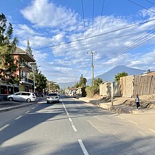
106:Streetscape in Sombetini, Aim Mall in Sombetini
19:Ward in Arusha City in Arusha Region, Tanzania
826:
577:
8:
833:
819:
584:
570:
562:
21:
470:
313:
278:
268:
247:
239:
226:
218:
176:
141:
110:
60:
394:The postal code for Sombetini Ward is
303:
285:
260:
252:
236:5.173 km (1.997 sq mi)
231:
206:
194:
7:
787:
785:
531:"Things to do in Arusha on a bduget"
14:
124:
789:
361:wards to the east. The wards of
182:
123:
116:
90:
79:
68:
447:Nakido Primary School (private)
438:Imani Primary School (private)
1:
862:Arusha Region geography stubs
444:Hady Primary School (private)
441:Green Valley School (private)
805:. You can help Knowledge by
265:9,300/km (24,000/sq mi)
244:1,348 m (4,423 ft)
743:Arusha Declaration Monument
593:Arusha City Council, Arusha
878:
784:
435:Sombetini Secondary School
349:. The ward is bordered by
599:
142:
111:
61:
48:
498:. Government of Tanzania
432:Sombetini Primary School
162:3.3866500°S 36.6674000°E
460:Sombetini Health Center
857:Wards of Arusha Region
801:location article is a
305: • Ancestral
223:Simanjiro Neighborhood
167:-3.3866500; 36.6674000
31:
517:"Sombetini Elevation"
408:Olamuriaki, Sombetini
315:Tanzanian Postal Code
852:Wards of Arusha City
419:Education and health
414:Simanjiro, Sombetini
287: • Settler
262: • Density
405:Kirika B, Sombetini
402:Kirika A, Sombetini
353:ward to the north,
339:Arusha City Council
214:Arusha City Council
158: /
103:From top to bottom:
739:Arusha Clock Tower
411:Osunyai, Sombetini
254: • Total
233: • Total
814:
813:
782:
781:
331:Kata ya Sombetini
324:
323:
32:Kata ya Sombetini
869:
835:
828:
821:
793:
786:
586:
579:
572:
563:
556:
555:
548:
542:
541:
539:
538:
527:
521:
520:
513:
507:
506:
504:
503:
497:
489:
483:
482:
475:
188:
186:
185:
173:
172:
170:
169:
168:
163:
159:
156:
155:
154:
151:
127:
126:
120:
94:
83:
72:
43:
42:
34:
22:
877:
876:
872:
871:
870:
868:
867:
866:
842:
841:
840:
839:
783:
778:
747:
728:
711:
605:
595:
590:
560:
559:
550:
549:
545:
536:
534:
529:
528:
524:
515:
514:
510:
501:
499:
495:
491:
490:
486:
477:
476:
472:
467:
454:
426:
421:
392:
383:
375:
341:located in the
320:
183:
181:
166:
164:
160:
157:
152:
149:
147:
145:
144:
138:
137:
136:
135:
134:
133:
132:
128:
107:
105:
100:
99:
98:
97:
96:
95:
86:
85:
84:
75:
74:
73:
57:
44:
36:
29:
27:
20:
17:
12:
11:
5:
875:
873:
865:
864:
859:
854:
844:
843:
838:
837:
830:
823:
815:
812:
811:
794:
780:
779:
777:
776:
771:
766:
761:
755:
753:
749:
748:
746:
745:
740:
736:
734:
730:
729:
727:
726:
723:
719:
717:
713:
712:
710:
709:
707:Terrat, Arusha
704:
699:
694:
689:
684:
679:
674:
669:
664:
659:
654:
649:
644:
639:
634:
629:
624:
619:
613:
611:
607:
606:
600:
597:
596:
591:
589:
588:
581:
574:
566:
558:
557:
543:
522:
508:
484:
469:
468:
466:
463:
462:
461:
453:
450:
449:
448:
445:
442:
439:
436:
433:
425:
422:
420:
417:
416:
415:
412:
409:
406:
403:
391:
390:Administration
388:
382:
379:
374:
371:
322:
321:
318:
316:
312:
311:
306:
302:
301:
288:
284:
283:
277:
276:
273:
267:
266:
263:
259:
258:
255:
251:
250:
246:
245:
242:
238:
237:
234:
230:
229:
225:
224:
221:
217:
216:
211:
205:
204:
199:
193:
192:
179:
175:
174:
140:
139:
130:
129:
122:
121:
115:
114:
113:
112:
109:
108:
101:
89:
88:
87:
78:
77:
76:
67:
66:
65:
64:
63:
62:
59:
58:
49:
46:
45:
28:
25:
18:
15:
13:
10:
9:
6:
4:
3:
2:
874:
863:
860:
858:
855:
853:
850:
849:
847:
836:
831:
829:
824:
822:
817:
816:
810:
808:
804:
800:
799:Arusha Region
795:
792:
788:
775:
772:
770:
767:
765:
762:
760:
757:
756:
754:
752:Ethnic Groups
750:
744:
741:
738:
737:
735:
731:
724:
721:
720:
718:
714:
708:
705:
703:
700:
698:
695:
693:
690:
688:
685:
683:
680:
678:
675:
673:
670:
668:
665:
663:
660:
658:
655:
653:
650:
648:
645:
643:
640:
638:
635:
633:
630:
628:
625:
623:
620:
618:
615:
614:
612:
608:
604:
598:
594:
587:
582:
580:
575:
573:
568:
567:
564:
553:
547:
544:
532:
526:
523:
518:
512:
509:
494:
488:
485:
480:
474:
471:
464:
459:
458:
457:
451:
446:
443:
440:
437:
434:
431:
430:
429:
423:
418:
413:
410:
407:
404:
401:
400:
399:
397:
389:
387:
380:
378:
372:
370:
368:
364:
360:
356:
352:
348:
344:
343:Arusha Region
340:
336:
332:
328:
317:
310:
307:
300:
296:
292:
289:
282:
281:Ethnic groups
274:
272:
264:
256:
243:
235:
222:
215:
212:
210:
203:
202:Arusha Region
200:
198:
191:
180:
171:
143:Coordinates:
119:
104:
93:
82:
71:
56:
52:
47:
40:
33:
23:
807:expanding it
796:
722:Kijenge Hill
697:Unga Limited
686:
622:Daraja Mbili
546:
535:. Retrieved
533:. The Medium
525:
511:
500:. Retrieved
487:
473:
455:
427:
395:
393:
384:
376:
355:Unga Limited
330:
326:
325:
220:Headquarters
153:36°40′2.64″E
150:3°23′11.94″S
102:
603:Arusha City
275:Sombetinian
165: /
55:Arusha City
846:Categories
725:Themi Hill
537:2023-03-11
502:2021-11-24
465:References
452:Healthcare
249:Population
733:Monuments
716:Landmarks
687:Sombetini
667:Ngarenaro
647:Kimandolu
601:Capital:
424:Education
373:Geography
327:Sombetini
241:Elevation
131:Sombetini
26:Sombetini
774:Waarusha
682:Sokoni I
672:Oloirien
657:Levolosi
637:Kaloleni
632:Engutoto
347:Tanzania
291:Waarusha
209:District
190:Tanzania
769:Koningo
702:Olasiti
662:Moshono
381:Economy
363:Olasiti
359:Sokon I
335:Swahili
309:Kinongo
271:Demonym
178:Country
39:Swahili
764:Maasai
759:Wameru
652:Lemara
627:Elerai
367:Terrat
351:Elerai
297:&
257:48,268
197:Region
187:
35:
797:This
692:Themi
677:Sekei
617:Baraa
610:Wards
496:(PDF)
396:23116
333:, in
319:23116
295:Iraqw
803:stub
642:Kati
365:and
357:and
299:Meru
228:Area
51:Ward
345:of
53:in
848::
293:,
834:e
827:t
820:v
809:.
585:e
578:t
571:v
554:.
540:.
519:.
505:.
481:.
329:(
41:)
37:(
Text is available under the Creative Commons Attribution-ShareAlike License. Additional terms may apply.