31:
44:
459:
51:
205:
345:
style, its tower being added in 1894. Prior to this, "Spittlers" had worshipped in a stable loft. There is also a nonconformist church, St Paul's, built in 1878. The village has several hotels and guest houses providing bed and breakfast, a village shop as well as a microbrewery.
340:
The name derives from a shortened form of "hospital"; a hospital, dedicated to St
Bartholomew, was built here in the Middle Ages to take care of lepers. St John's, the parish church, was built in 1867 in the
245:
500:
253:
82:
229:
362:
524:
191:
222:
43:
289:
493:
519:
217:
30:
486:
281:
271:
179:
145:
109:
99:
75:
234:
436:
276:
358:
159:
342:
91:
441:
330:
210:
135:
127:
419:
470:
184:
466:
458:
442:
Some unusual ripple marks in
Carboniferous limestone near Spittal, north Northumberland
326:
117:
64:
513:
373:
393:
334:
304:
291:
169:
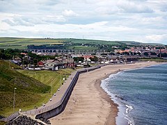
337:. Spittal Beach is considered one of the best beaches in Northumberland.
151:
376:
was born here and she became a suffragette and film actor.
474:
244:
228:
216:
204:
190:
178:
168:
158:
144:
126:
108:
90:
74:
23:
494:
8:
333:and is situated on the coast to the east of
437:St John the Evangelist, a church in Spittal
501:
487:
20:
385:
243:
199:
167:
143:
73:
27:
227:
215:
203:
189:
177:
157:
125:
107:
89:
7:
455:
453:
414:
412:
410:
473:. You can help Knowledge (XXG) by
14:
457:
394:"Best Beaches in Northumberland"
49:
42:
29:
50:
525:Northumberland geography stubs
1:
76:OS grid reference
18:Human settlement in England
541:
520:Villages in Northumberland
452:
420:"Spittal, Northumberland"
329:, England. It is part of
325:is a village in northern
262:
240:
200:
37:
28:
469:location article is a
180:Postcode district
110:Ceremonial county
92:Unitary authority
254:North Northumberland
160:Sovereign state
301: /
422:. Britain Express.
363:Berwick-upon-Tweed
331:Berwick-upon-Tweed
246:UK Parliament
192:Dialling code
174:BERWICK-UPON-TWEED
482:
481:
320:
319:
532:
503:
496:
489:
461:
454:
424:
423:
416:
405:
404:
402:
400:
390:
361:constituency of
316:
315:
313:
312:
311:
306:
305:55.756°N 1.993°W
302:
299:
298:
297:
294:
268:
154:
86:
85:
63:Location within
53:
52:
46:
33:
21:
540:
539:
535:
534:
533:
531:
530:
529:
510:
509:
508:
507:
450:
447:
433:
428:
427:
418:
417:
408:
398:
396:
392:
391:
387:
382:
371:
352:
309:
307:
303:
300:
295:
292:
290:
288:
287:
286:
266:
258:
150:
140:
122:
104:
81:
80:
70:
69:
68:
67:
61:
60:
59:
58:
54:
19:
12:
11:
5:
538:
536:
528:
527:
522:
512:
511:
506:
505:
498:
491:
483:
480:
479:
467:Northumberland
462:
445:
444:
439:
432:
431:External links
429:
426:
425:
406:
384:
383:
381:
378:
370:
367:
351:
348:
327:Northumberland
318:
317:
310:55.756; -1.993
285:
284:
282:Northumberland
279:
274:
269:
267:List of places
263:
260:
259:
257:
256:
250:
248:
242:
241:
238:
237:
232:
226:
225:
223:Northumberland
220:
214:
213:
208:
202:
201:
198:
197:
194:
188:
187:
182:
176:
175:
172:
166:
165:
164:United Kingdom
162:
156:
155:
148:
142:
141:
139:
138:
132:
130:
124:
123:
121:
120:
118:Northumberland
114:
112:
106:
105:
103:
102:
100:Northumberland
96:
94:
88:
87:
78:
72:
71:
65:Northumberland
62:
56:
55:
48:
47:
41:
40:
39:
38:
35:
34:
26:
25:
17:
13:
10:
9:
6:
4:
3:
2:
537:
526:
523:
521:
518:
517:
515:
504:
499:
497:
492:
490:
485:
484:
478:
476:
472:
468:
463:
460:
456:
451:
448:
443:
440:
438:
435:
434:
430:
421:
415:
413:
411:
407:
395:
389:
386:
379:
377:
375:
374:Maggie Moffat
368:
366:
364:
360:
359:parliamentary
356:
349:
347:
344:
343:Early English
338:
336:
332:
328:
324:
314:
283:
280:
278:
275:
273:
270:
265:
264:
261:
255:
252:
251:
249:
247:
239:
236:
233:
231:
224:
221:
219:
212:
209:
207:
195:
193:
186:
183:
181:
173:
171:
163:
161:
153:
149:
147:
137:
134:
133:
131:
129:
119:
116:
115:
113:
111:
101:
98:
97:
95:
93:
84:
79:
77:
66:
45:
36:
32:
22:
16:
475:expanding it
464:
449:
446:
397:. Retrieved
388:
372:
354:
353:
339:
322:
321:
15:
399:26 February
308: /
211:Northumbria
514:Categories
380:References
357:is in the
350:Governance
335:Tweedmouth
293:55°45′22″N
235:North East
136:North East
296:1°59′35″W
230:Ambulance
170:Post town
83:NU005515
355:Spittal
323:Spittal
277:England
152:England
146:Country
57:Spittal
24:Spittal
369:People
206:Police
128:Region
465:This
196:01289
471:stub
401:2007
218:Fire
185:TD15
516::
409:^
365:.
272:UK
502:e
495:t
488:v
477:.
403:.
Text is available under the Creative Commons Attribution-ShareAlike License. Additional terms may apply.

