495:
south side of the
Skillington road between 1961 and 1973, again working eastwards. A further iron ore quarry was worked on the north side of the railway between 1962 and 1963 again working eastward from the Saltby road. The ore was taken to the railway by standard gauge tramways, worked by horses from 1925 to 1928, then by a petrol engined locomotive and from 1931 by steam locomotives. From 1961 some of the ore was taken to the railway by lorry and from October 1963 the last of the tramways was abandoned and all of the stone was taken to the railway by lorry. Steam quarrying machines were used until 1940 when electric and diesel machines were introduced.
38:
54:
61:
239:
474:
A post mill stood at
Sproxton. The mill was rebuilt in 1889 after it blew down and killed the miller. Wakes & Lamb of Newark rebuilt the mill using materials from the old mill and from one at Castle Bytham. It was wrecked by the gales of March 1916, but repaired. By 1920 it was out of use and was
494:
The first quarry was for iron ore close to the road between the railway and
Sproxton Church and worked its way eastwards until 1961. The quarry was extended eastwards and southwards between 1965 and 1968 but for the getting of limestone rather than iron ore. A second iron ore quarry operated on the
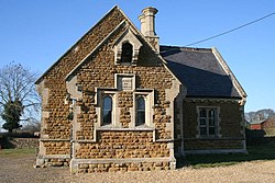
471:, is a Grade II* listed building. There is evidence of Norman building in the west wall of the south aisle and the tower is 13th-century. The top part of the tower was rebuilt in the restoration of 1882. There is a Saxon cross in the churchyard - the only complete one in Leicestershire.
515:
531:
498:
Some of the quarried area has been restored for agriculture (in places it looks hummocky). Some has been forested and the final gullets and the limestone quarry remain. There are traces of the railway and tipping dock.
483:
Quarrying for iron ore was carried out at
Sproxton from 1925 to 1973 and for limestone from 1965 to 1969. The stone was taken away by a railway, construction of which was started in about 1922 by the
279:
143:
256:
100:
263:
287:
491:. The terminus was on the east side of the Sproxton to Saltby road. It was planned to extend the line to Waltham Station but this extension was never opened.
323:
407:. It has approximately 80 occupied dwellings (2021) and a population of 480, rising to 658 (including Coston, Saltby and Stonesby) at the 2011 census.
711:
225:
53:
484:
706:
461:
251:
566:
665:
634:
597:
561:
315:
305:
454:
268:
213:
179:
37:
691:
93:
716:
612:
Leicestershire
Historian Spring 1971 www.le.ac.uk/lahs/downloads/LeicestershireHistorian-Vol.2No.1-Spring1971.pdf
427:
310:
17:
193:
439:
244:
431:
125:
161:
410:
The village and civil parish are not coterminous; the parish includes the villages of
Sproxton,
661:
630:
593:
467:
The 14th-century parish church of St
Bartholomew, extended and restored in 1882 by architect
557:
396:
362:
218:
133:
458:
435:
400:
151:
74:
700:
468:
169:
404:
392:
109:
684:
447:
443:
653:
622:
423:
338:
325:
203:
487:
The line was an extension of the branch from the main line at High Dyke to
415:
488:
419:
185:
411:
383:
658:
The
Ironstone Quarries of the Midlands Part 9: Leicestershire
627:
The
Ironstone Quarries of the Midlands Part 9: Leicestershire
592:. The Buildings of England. London: Penguin. pp. 383–4.
377:
380:
368:
374:
371:
629:. Cheltenham: Runpast Publishing. p. 193–196.
365:
278:
262:
250:
238:
224:
212:
202:
192:
178:
160:
142:
124:
108:
92:
84:
30:
518:Census 2001 : Parish Headcounts : Melton
588:Pevsner, Nikolaus; Williamson, Elizabeth (1992).
475:demolished in 1949 when owned by Mr T.A.Mount.
8:
430:runs through the parish. Nearby places are
27:
508:
277:
233:
201:
177:
91:
34:
516:Office for National Statistics :
261:
249:
237:
223:
211:
191:
159:
141:
123:
7:
648:
646:
562:"CHURCH OF ST BARTHOLOMEW (1294595)"
403:, England, close to the border with
462:Site of Special Scientific Interest
660:. Cheltenham: Runpast Publishing.
567:National Heritage List for England
14:
712:Civil parishes in Leicestershire
538:. Office for National Statistics
361:
60:
59:
52:
36:
532:"Civil Parish population 2011"
1:
94:OS grid reference
25:Human settlement in England
733:
707:Villages in Leicestershire
590:Leicestershire and Rutland
15:
521:Retrieved 20 January 2010
457:runs close by. Nearby is
296:
274:
234:
47:
35:
18:Sproxton (disambiguation)
536:Neighbourhood Statistics
485:Great Northern Railway.
214:Postcode district
685:Sproxton Jubilee Site
339:52.81137°N 0.730609°W
42:Sproxton Village Hall
432:Waltham on the Wolds
194:Sovereign state
16:For other uses, see
450:(in Lincolnshire).
391:) is a village and
344:52.81137; -0.730609
335: /
288:Rutland and Melton
280:UK Parliament
226:Dialling code
717:Borough of Melton
422:, and the former
397:Borough of Melton
354:
353:
144:Shire county
724:
692:Open Gardens Day
672:
671:
650:
641:
640:
619:
613:
610:
604:
603:
585:
579:
578:
576:
574:
558:Historic England
554:
548:
547:
545:
543:
528:
522:
513:
390:
389:
386:
385:
382:
379:
376:
373:
370:
367:
350:
349:
347:
346:
345:
340:
336:
333:
332:
331:
328:
302:
188:
104:
103:
73:Location within
63:
62:
56:
40:
28:
732:
731:
727:
726:
725:
723:
722:
721:
697:
696:
681:
676:
675:
668:
652:
651:
644:
637:
621:
620:
616:
611:
607:
600:
587:
586:
582:
572:
570:
556:
555:
551:
541:
539:
530:
529:
525:
514:
510:
505:
481:
459:Sproxton Quarry
436:Croxton Kerrial
364:
360:
343:
341:
337:
334:
329:
326:
324:
322:
321:
320:
300:
292:
184:
174:
156:
138:
120:
99:
98:
88:658 (2011)
80:
79:
78:
77:
71:
70:
69:
68:
64:
43:
26:
21:
12:
11:
5:
730:
728:
720:
719:
714:
709:
699:
698:
695:
694:
689:
687:
680:
679:External links
677:
674:
673:
666:
642:
635:
614:
605:
598:
580:
549:
523:
507:
506:
504:
501:
480:
477:
401:Leicestershire
352:
351:
319:
318:
316:Leicestershire
313:
308:
303:
301:List of places
297:
294:
293:
291:
290:
284:
282:
276:
275:
272:
271:
266:
260:
259:
257:Leicestershire
254:
248:
247:
245:Leicestershire
242:
236:
235:
232:
231:
228:
222:
221:
216:
210:
209:
208:MELTON MOWBRAY
206:
200:
199:
198:United Kingdom
196:
190:
189:
182:
176:
175:
173:
172:
166:
164:
158:
157:
155:
154:
152:Leicestershire
148:
146:
140:
139:
137:
136:
130:
128:
122:
121:
119:
118:
114:
112:
106:
105:
96:
90:
89:
86:
82:
81:
75:Leicestershire
72:
66:
65:
58:
57:
51:
50:
49:
48:
45:
44:
41:
33:
32:
24:
13:
10:
9:
6:
4:
3:
2:
729:
718:
715:
713:
710:
708:
705:
704:
702:
693:
690:
688:
686:
683:
682:
678:
669:
667:1-870-754-085
663:
659:
655:
649:
647:
643:
638:
636:1-870-754-085
632:
628:
624:
618:
615:
609:
606:
601:
599:0-14-071018-3
595:
591:
584:
581:
569:
568:
563:
559:
553:
550:
537:
533:
527:
524:
520:
519:
512:
509:
502:
500:
496:
492:
490:
486:
478:
476:
472:
470:
469:Henry Woodyer
465:
463:
460:
456:
451:
449:
445:
441:
437:
433:
429:
425:
421:
417:
413:
408:
406:
402:
398:
394:
388:
358:
348:
317:
314:
312:
309:
307:
304:
299:
298:
295:
289:
286:
285:
283:
281:
273:
270:
269:East Midlands
267:
265:
258:
255:
253:
246:
243:
241:
229:
227:
220:
217:
215:
207:
205:
197:
195:
187:
183:
181:
171:
170:East Midlands
168:
167:
165:
163:
153:
150:
149:
147:
145:
135:
132:
131:
129:
127:
116:
115:
113:
111:
107:
102:
97:
95:
87:
83:
76:
55:
46:
39:
29:
23:
19:
657:
626:
617:
608:
589:
583:
571:. Retrieved
565:
552:
540:. Retrieved
535:
526:
517:
511:
497:
493:
482:
473:
466:
452:
409:
405:Lincolnshire
393:civil parish
356:
355:
110:Civil parish
22:
654:Tonks, Eric
623:Tonks, Eric
573:18 November
448:Skillington
444:Buckminster
395:within the
342: /
701:Categories
503:References
455:Viking Way
424:RAF Saltby
327:52°48′41″N
85:Population
479:Quarrying
428:River Eye
330:0°43′50″W
264:Ambulance
204:Post town
656:(1992).
625:(1992).
416:Stonesby
357:Sproxton
126:District
117:Sproxton
101:SK855245
67:Sproxton
31:Sproxton
542:10 June
489:Stainby
420:Bescaby
311:England
186:England
180:Country
664:
633:
596:
446:, and
440:Coston
426:. The
412:Saltby
240:Police
162:Region
134:Melton
230:01476
662:ISBN
631:ISBN
594:ISBN
575:2013
544:2016
453:The
252:Fire
219:LE14
399:in
703::
645:^
564:.
560:.
534:.
464:.
442:,
438:,
434:,
418:,
414:,
384:ən
378:oʊ
306:UK
670:.
639:.
602:.
577:.
546:.
387:/
381:s
375:r
372:p
369:s
366:ˈ
363:/
359:(
20:.
Text is available under the Creative Commons Attribution-ShareAlike License. Additional terms may apply.