313:
278:
forbidden to hunt, fish, cut native species, open fire breaks, thin the forest or subdivide it into fields. From 1954 visitors could access Porto Garcia, a beach on the
Uruguay River. Decree 17.432 of 11 August 1965 altered the limits of the park. It lost 146.1 hectares (361 acres). The park was mapped in 1976, and its management plan published in 1980. In 1983 a 14.8 kilometres (9.2 mi) road was opened from the park boundary to the Yucumã Falls, and a 2 hectares (4.9 acres) visitor's area was opened at the falls with tables, rustic benches and barbecues. Toilets and kiosks with barbecues and sinks were added at the end of the 1980s.
237:
71:
305:
257:
289:(IBAMA) terms of reference for licensing did not conform to the park's legislation and was not approved by the state secretariat of the environment (SEMA). In April 2015 the regional federal tribunal upheld the suspension, since the IBAMA Environmental Impact Study would have been "flagrantly illegal". The rapporteur noted that the hydroelectric project should conform to the park's requirements rather than the reverse.
492:
248:
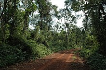
also houses the park staff. There is a "trail of ponds" at the visitor center which may only be visited when accompanied by a guide. A 15 kilometres (9.3 mi) dirt trail for vehicles leads from the visitor center to the falls. In the leisure area by the falls there is a house used only by the park rangers. There are bathrooms, shelters and grills for use by visitors, but no electricity or drinking water.
78:
230:), a dramatic linear waterfall on the border with Argentina. These have been called one of the seven wonders of the state. The park is open to the public from Wednesday to Sunday, with a small admission fee. There are two trails in the park, Garcia and Yucumã, both accessible to vehicles, but only the Yucumã trail is open to the public.
55:
332:
The Turvo State Park has the last large area of Upper
Uruguay forest in the state, with over 700 plant species. The original forest is elsewhere largely replaced with soy and wheat monocultures. The forest typically has an upper statrum of mainly deciduous trees that lose their leaves in winter. The
247:
Pets are not allowed in the park, and fishing and hunting are prohibited. There is no accommodation in the park, and camping is not allowed. There is a visitor center just inside the park entrance, with a biodiversity exhibition, environmental education space, auditorium and washrooms. The building
511:
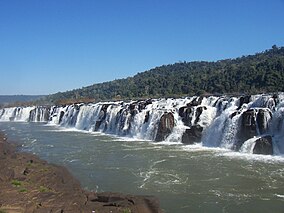
river waters spill into the trench along its entire length, with a drop of 12 to 15 metres (39 to 49 ft). From the visitor's area there is a 600 metres (2,000 ft) path to the river. Visitors may walk along the rocky stretch opposite the falls between the forest edge and the river bank.
510:
The trench is visible at the Yucumã Falls, where the river flows along the edge of the trench and spills into it. In this section of about 1,800 metres (5,900 ft) the trench has with an average width of 30 metres (98 ft) and depth estimated at 90 to 120 metres (300 to 390 ft). The
277:
Law 2440 of 2 October 1954 transformed all forests owned by the state with over 250 hectares (620 acres) into state parks, apart from areas that had deforested or transformed into rural lots. As a result, the Turvo State Forest
Reserve became the Turvo State Forest Park. In state parks it is
333:
canopy has an average height of 20 metres (66 ft) and emergent individuals of 30 metres (98 ft). Below this is a stratum of dense perennial trees from 10 to 20 metres (33 to 66 ft) tall that retain their leaves in winter. Below this are saplings, shrubs and grasses.
324:
Basin. Altitudes are from 100 to 400 metres (330 to 1,310 ft) above sea level. The terrain has steep slopes that drain into valleys that open to the north and west. The soil is clayey, dark red, shallow, fast-draining and very susceptible to erosion. The
264:
Turvo was one of the first conservation units in the state and the largest fully protected unit. The area was made a state forest reserve by decree 2.312 on 11 March 1947, protecting untouched lands covered with native forest on the banks of the
406:). There are also rocky outcrops covered by lichens, mosses and herbs such as petunia and verbena. The rocky formations on the banks of the Uruguay River are adapted to periods of flooding followed by dry, sunny periods. The endemic bromeliad
483:. There is a variety of amphibians and reptiles and many types of insect. Studies of amphibians along the Garcia and Yucumã trails in 2003–05 found species that are often associated with crops, indicating influence by the nearby farmland.
273:
and Pari rivers, then in the
Tenente Portela district. The objective was to protect the forest and provide refuge for fauna. Any type of alienation, lease or encumbrance, or any agricultural or industrial exploitation was prohibited.
503:, if falls divided by islands are excluded. They are best viewed from the Brazilian side. They are formed by a trench or submerged canyon that runs along the bed of the Uruguay River. The deep and narrow canyon formed during the
286:
183:, Brazil. It protects the last large area of well-preserved Upper Uruguay forest in the state, which is home to several rare or endangered species. The park is best known for the dramatic Yucumã Falls on the
800:
329:
is "Cfa": subtropical temperate humid, with frequent fogs, average annual rainfall up to 1,900 millimetres (75 in) and average daily temperatures from 6.6 to 37.4 °C (43.9 to 99.3 °F).
819:
415:
There are almost 290 species of birds and more than 30 species of medium and large mammals. Many of the species are rare, and some are regionally or globally threatened. Fauna include
285:. The main issue was that the reservoir would flood 60 hectares (150 acres) of the Turvo State Park, which holds regionally threatened flora and fauna, some at risk of extinction. The
507:
at a time when the climate was drier and the river was not as wide. It is now no longer visible along most of the river, although the strong current has kept it clear of sediments.
514:
The waterfalls are best viewed in the dry season between
November and March or April. At other times the flood waters submerge the falls. They may be threatened by the planned
959:
Schmidt, Letícia Santos; Barcellos, Aline (2007), "Abundância e riqueza de espécies de
Heteroptera (Hemiptera) do Parque Estadual do Turvo, sul do Brasil: Pentatomoidea",
1027:
281:
At the request of the
Federal Public Ministry, in January 2015 a federal judge granted a preliminary injunction to stop the environmental licensing process for the
1017:
96:
515:
188:
1022:
873:
70:
296:, which aims to provide forest connections between conservation units in Brazil, Paraguay and Argentina in the Upper Paraná ecoregion.
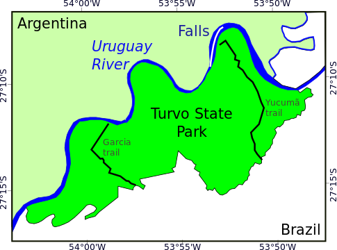
211:. The park is bounded to the west by the Turvo River and to the east by the Parizinho River. There are rural properties to the south.
312:
293:
896:(in Portuguese), SEMA: Secretaria do Ambiente e Desenvolvimento Sustentável do Rio Grande do Sul, 19 September 2010, archived from
780:
891:
326:
270:
1012:
40:
981:
855:
1007:
236:
392:
368:
518:. However, Electrobras has stated that flooding in Turvo could only occur during the river's flood periods.
187:, the second-widest in the world by some measures. The falls may be threatened by flooding from the planned
199:
The Turvo State Park is in the
Northwest of Rio Grande do Sul, covering almost half of the municipality of
348:
204:
838:
338:
499:
The Yucumã (or Moconá) falls are the second widest in the world after the 2,682 metres (8,799 ft)
408:
378:
432:
17:
504:
215:
176:
168:
139:
801:"Ambientalistas cerram fileiras contrárias aos novos aproveitamentos hidrelétricos do Rio Uruguai"
358:
452:
180:
968:
927:
535:
424:
304:
223:
698:
696:
694:
692:
690:
688:
686:
684:
682:
256:
321:
820:"Justiça paralisa processo de licenciamento ambiental da Usina hidrelétrica de Panambi"
402:
282:
897:
608:
606:
1001:
779:
Araújo Corte, Dione Angélica de; Valladares-Pádua, Cláudio
Benedito (November 2007),
476:
266:
208:
184:
44:
973:
491:
203:. It has an area of 17,491.40 hectares (43,222.2 acres). To the north Argentina and
500:
669:
667:
200:
658:
111:
98:
911:
702:
593:
591:
589:
943:
412:
is found in a few places on the river banks and is at risk of extinction.
627:
625:
623:
621:
468:
612:
726:
559:
444:
416:
986:(in Portuguese), Tribunal Regional Federal da 4a Região, 4 May 2015
54:
490:
480:
460:
311:
303:
287:
Brazilian
Institute of Environment and Renewable Natural Resources
255:
642:
640:
440:
738:
631:
983:
TRF4 mantém suspenso licenciamento de Hidrelétrica Panambi
576:
574:
572:
570:
568:
782:
Plano de Manejo da Estação Ecológica Mico-Leão-Preto
874:"Parque Estadual do Turvo emite aviso a visitantes"
153:
145:
135:
127:
90:
28:
659:Parque Estadual do Turvo emite aviso a visitantes
320:The park is in the Basaltic Laval Plateau of the
750:
646:
703:Parque Florestal Estadual do Turvo – Derrubadas
948:(in Portuguese), ISA: Instituto Socioambiental
673:
597:
8:
613:Parque Estadual do Turvo – Dicas de Passeios
580:
727:TRF4 mantém suspenso licenciamento ... 2015
25:
972:
560:Parque do Turvo – Municipio de Derrubadas
932:(in Portuguese), Municipio de Derrubadas
916:(in Portuguese), Derrubadas municipality
739:Araújo Corte & Valladares-Pádua 2007
77:
552:
527:
316:Margay photographed in Turvo State Park
292:The park would be part of the proposed
232:
23:State park in Rio Grande do Sul, Brazil
1028:Protected areas of the Atlantic Forest
762:
714:
191:if a 2015 court ruling is overturned.
7:
1018:Protected areas of Rio Grande do Sul
516:Garabí-Panambi Hydroelectric Complex
214:The park includes the Yucumã Falls (
189:Garabí-Panambi Hydroelectric Complex
913:Parque Florestal Estadual do Turvo
14:
788:(in Portuguese), Brasília: ICMBio
294:Trinational Biodiversity Corridor
880:(in Portuguese), 9 November 2016
818:Cigana, Caio (27 January 2015),
235:
76:
69:
53:
974:10.1590/S0073-47212007000100011
632:Parque Estadual do Turvo – SEMA
545:means "to swallow everything".
336:Important tree species include
144:
799:Cigana, Caio (29 March 2014),
131:17,491 hectares (43,220 acres)
1:
1023:1947 establishments in Brazil
839:"Moconá Falls (Yucumã Falls)"
327:Köppen climate classification
751:Schmidt & Barcellos 2007
647:Schmidt & Barcellos 2007
837:Gatis Pavils (2012-02-15),
1044:
856:"Parque Estadual do Turvo"
269:between the mouths of the
207:are the other side of the
20:in the state of São Paulo.
15:
961:Iheringia. Série Zoologia
541:means "the big fall" and
473:Hydrochoerus hydrochaeris
64:
52:
38:
33:
893:Parque Estadual do Turvo
393:Aspidosperma parviflorum
369:Tetrochidium rubrevinium
173:Parque Estadual do Turvo
34:Parque Estadual do Turvo
16:Not to be confused with
386:). Other trees include
112:27.202077°S 53.897995°W
496:
495:Shoreline of the falls
317:
309:
261:
227:
219:
172:
117:-27.202077; -53.897995
59:Yucumã or Moconá Falls
1013:State parks of Brazil
676:, Historico Juridico.
494:
457:Tamandua tetradactyla
315:
307:
259:
433:South American tapir
349:Ocotea diospyrifolia
308:Interior of the park
18:Rio Turvo State Park
900:on 12 November 2016
505:last glacial period
108: /
674:PES do Turvo – ISA
600:, Características.
598:PES do Turvo – ISA
497:
449:Leopardus pardalis
437:Tapirus terrestris
359:Cabralea canjerana
339:Sorocea bonplandii
318:
310:
262:
963:(in Portuguese),
860:Dicas de Passeios
581:Gatis Pavils 2012
453:southern tamandua
409:Dickia brevifolia
379:Apuléia leiocarpa
228:Saltos del Moconá
181:Rio Grande do Sul
161:
160:
1035:
1008:IUCN Category II
993:
992:
991:
977:
976:
955:
954:
953:
939:
938:
937:
923:
922:
921:
907:
906:
905:
887:
886:
885:
878:Três Passos News
869:
868:
867:
851:
850:
849:
833:
832:
831:
814:
813:
812:
795:
794:
793:
787:
766:
760:
754:
748:
742:
736:
730:
724:
718:
712:
706:
700:
677:
671:
662:
656:
650:
644:
635:
629:
616:
610:
601:
595:
584:
578:
563:
557:
546:
536:Guarani language
532:
425:collared peccary
260:Road in the park
239:
179:in the state of
165:Turvo State Park
123:
122:
120:
119:
118:
113:
109:
106:
105:
104:
101:
80:
79:
73:
57:
29:Turvo State Park
26:
1043:
1042:
1038:
1037:
1036:
1034:
1033:
1032:
998:
997:
996:
989:
987:
980:
958:
951:
949:
942:
935:
933:
929:Parque do Turvo
926:
919:
917:
910:
903:
901:
890:
883:
881:
872:
865:
863:
862:(in Portuguese)
854:
847:
845:
836:
829:
827:
826:(in Portuguese)
817:
810:
808:
807:(in Portuguese)
798:
791:
789:
785:
778:
774:
769:
761:
757:
749:
745:
737:
733:
725:
721:
713:
709:
701:
680:
672:
665:
657:
653:
645:
638:
630:
619:
611:
604:
596:
587:
579:
566:
558:
554:
550:
549:
533:
529:
524:
489:
302:
254:
243:
240:
220:Salto do Yucumã
197:
116:
114:
110:
107:
102:
99:
97:
95:
94:
86:
85:
84:
83:
82:
81:
60:
48:
24:
21:
12:
11:
5:
1041:
1039:
1031:
1030:
1025:
1020:
1015:
1010:
1000:
999:
995:
994:
978:
956:
940:
924:
908:
888:
870:
852:
834:
815:
796:
775:
773:
770:
768:
767:
755:
743:
731:
719:
707:
678:
663:
651:
636:
617:
602:
585:
564:
551:
548:
547:
526:
525:
523:
520:
488:
485:
403:Cassia fistula
301:
298:
253:
250:
245:
244:
241:
234:
205:Santa Catarina
196:
193:
159:
158:
155:
151:
150:
147:
143:
142:
137:
133:
132:
129:
125:
124:
92:
88:
87:
75:
74:
68:
67:
66:
65:
62:
61:
58:
50:
49:
39:
36:
35:
31:
30:
22:
13:
10:
9:
6:
4:
3:
2:
1040:
1029:
1026:
1024:
1021:
1019:
1016:
1014:
1011:
1009:
1006:
1005:
1003:
985:
984:
979:
975:
970:
966:
962:
957:
947:
946:
941:
931:
930:
925:
915:
914:
909:
899:
895:
894:
889:
879:
875:
871:
861:
857:
853:
844:
840:
835:
825:
821:
816:
806:
802:
797:
784:
783:
777:
776:
771:
764:
759:
756:
753:, p. 73.
752:
747:
744:
741:, p. 23.
740:
735:
732:
728:
723:
720:
716:
711:
708:
704:
699:
697:
695:
693:
691:
689:
687:
685:
683:
679:
675:
670:
668:
664:
660:
655:
652:
649:, p. 75.
648:
643:
641:
637:
633:
628:
626:
624:
622:
618:
614:
609:
607:
603:
599:
594:
592:
590:
586:
582:
577:
575:
573:
571:
569:
565:
561:
556:
553:
544:
540:
537:
531:
528:
521:
519:
517:
512:
508:
506:
502:
493:
486:
484:
482:
478:
477:howler monkey
474:
470:
466:
462:
458:
454:
450:
446:
442:
438:
434:
430:
429:Pecari tajacu
426:
422:
421:Puma concolor
418:
413:
411:
410:
405:
404:
399:
395:
394:
389:
385:
381:
380:
375:
371:
370:
365:
361:
360:
355:
351:
350:
345:
341:
340:
334:
330:
328:
323:
314:
306:
299:
297:
295:
290:
288:
284:
279:
275:
272:
268:
267:Uruguay River
258:
251:
249:
238:
233:
231:
229:
225:
221:
217:
212:
210:
209:Uruguay River
206:
202:
194:
192:
190:
186:
185:Uruguay River
182:
178:
174:
170:
166:
156:
154:Administrator
152:
149:11 March 1947
148:
141:
138:
134:
130:
126:
121:
93:
89:
72:
63:
56:
51:
46:
45:national park
42:
41:IUCN category
37:
32:
27:
19:
988:, retrieved
982:
967:(1): 73–79,
964:
960:
950:, retrieved
945:PES do Turvo
944:
934:, retrieved
928:
918:, retrieved
912:
902:, retrieved
898:the original
892:
882:, retrieved
877:
864:, retrieved
859:
846:, retrieved
842:
828:, retrieved
823:
809:, retrieved
804:
790:, retrieved
781:
758:
746:
734:
722:
710:
654:
555:
542:
538:
530:
513:
509:
501:Iguazu Falls
498:
487:Yucumã Falls
472:
465:Eira barbara
464:
456:
448:
436:
428:
420:
414:
407:
401:
397:
391:
387:
383:
377:
373:
367:
363:
357:
353:
347:
343:
337:
335:
331:
322:Paraná River
319:
291:
280:
276:
263:
246:
213:
198:
164:
162:
843:Wondermondo
763:Cigana 2014
715:Cigana 2015
398:canafístula
300:Environment
283:Panambí Dam
136:Designation
115: /
91:Coordinates
1002:Categories
990:2016-11-12
952:2016-11-11
936:2016-11-11
920:2016-11-11
904:2016-11-11
884:2016-11-12
866:2016-11-12
848:2016-11-11
830:2016-11-12
811:2016-11-11
792:2016-11-11
242:Sketch map
216:Portuguese
201:Derrubadas
177:state park
169:Portuguese
140:State park
103:53°53′53″W
100:27°12′07″S
824:Zero Hora
805:Zero Hora
364:canjerana
469:capybara
388:guatambu
195:Location
772:Sources
534:In the
374:embirão
252:History
224:Spanish
175:) is a
157:SEMA/RS
146:Created
543:Moconá
539:Yucumã
445:ocelot
417:cougar
396:) and
384:grápia
376:) and
354:canela
344:cincho
786:(PDF)
522:Notes
481:otter
461:tayra
271:Turvo
479:and
441:deer
163:The
128:Area
43:II (
969:doi
475:),
467:),
459:),
451:),
439:),
431:),
423:),
366:),
356:),
346:),
1004::
965:97
876:,
858:,
841:,
822:,
803:,
681:^
666:^
639:^
620:^
605:^
588:^
567:^
443:,
226::
222:,
218::
171::
971::
765:.
729:.
717:.
705:.
661:.
634:.
615:.
583:.
562:.
471:(
463:(
455:(
447:(
435:(
427:(
419:(
400:(
390:(
382:(
372:(
362:(
352:(
342:(
167:(
47:)
Text is available under the Creative Commons Attribution-ShareAlike License. Additional terms may apply.