107:
170:
93:
20:
73:
The five main settlements in the
Tuxertal are (from the head of the valley): Hintertux (1,500 m), Madseit (1,385 m), Juns (1360 m), Tux (former Lanersbach) (1,300 m), Vorderlanersbach (1,300 m) and the parish of
230:
211:
131:
106:
62:, the village that gives the valley its name, there is a height difference of about 850 m. The valley ends at Hintertux and the
235:
204:
54:
197:
51:, the Tuxertal is about 13 km long and accessible on the Tuxer Straße (Tux Road). From Mayrhofen (
66:. The Tuxbach, which rises near Hintertux, flows as far as Mayrhofen where it empties into the River
81:
The
Tuxertal is the only way of reaching the Hintertux Glacier by means of road and cable lift.
63:
181:
92:
169:
224:
177:
32:
59:
40:
98:
75:
146:
133:
48:
44:
123:
36:
19:
67:
18:
185:
58:) to Hintertux (1500 m) in the municipality of
124:The Tuxertal - the westernmost of the side valleys
205:
8:
212:
198:
88:
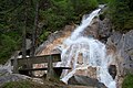
23:Lanersbach in Tuxertal, Tyrol, Austria
7:
166:
164:
184:. You can help Knowledge (XXG) by
14:
112:Tuxbach stream, fed by meltwaters
231:Valleys of Tyrol (federal state)
168:
105:
91:
1:
47:, from which it branches at
252:
163:
16:Valley in Tyrol, Austria
31:is a valley located in
180:location article is a
24:
236:Tyrol geography stubs
147:47.16250°N 11.75417°E
22:
143: /
152:47.16250; 11.75417
25:
193:
192:
64:Hintertux Glacier
243:
214:
207:
200:
172:
165:
158:
157:
155:
154:
153:
148:
144:
141:
140:
139:
136:
109:
95:
57:
251:
250:
246:
245:
244:
242:
241:
240:
221:
220:
219:
218:
161:
151:
149:
145:
142:
137:
134:
132:
130:
129:
120:
113:
110:
101:
96:
87:
52:
17:
12:
11:
5:
249:
247:
239:
238:
233:
223:
222:
217:
216:
209:
202:
194:
191:
190:
173:
127:
126:
119:
118:External links
116:
115:
114:
111:
104:
102:
97:
90:
86:
83:
78:(840 m).
15:
13:
10:
9:
6:
4:
3:
2:
248:
237:
234:
232:
229:
228:
226:
215:
210:
208:
203:
201:
196:
195:
189:
187:
183:
179:
174:
171:
167:
162:
159:
156:
125:
122:
121:
117:
108:
103:
100:
94:
89:
84:
82:
79:
77:
71:
69:
65:
61:
56:
50:
46:
42:
38:
34:
30:
21:
186:expanding it
175:
160:
128:
80:
72:
28:
26:
150: /
55:m (AA)
41:side valley
225:Categories
138:11°45′15″E
99:Tux cattle
76:Finkenberg
135:47°9′45″N
53:630
49:Mayrhofen
45:Zillertal
29:Tuxertal
85:Gallery
43:of the
37:Austria
68:Ziller
178:Tyrol
176:This
33:Tyrol
182:stub
39:. A
27:The
60:Tux
227::
70:.
35:,
213:e
206:t
199:v
188:.
Text is available under the Creative Commons Attribution-ShareAlike License. Additional terms may apply.