133:
148:
629:
301:
167:
22:
534:
233:
174:
506:
since 1707. The town was situated beside an often attended trade route to
Hungary which guaranteed good opportunities for development, but as time passed the town started to decline, and by 1876 it had lost municipal rights.
595:
562:. Slownik Historyczno-Geograficzny Ziemi Sanockiej w Średniowieczu (Historic-Geographic Dictionary of the Sanok District in the Middle Ages), Kraków, 2002,
132:
515:
In the immediate years after World War II (1945, 1946) some inhabitants left for the
Ukraine. On 29 April 1946 the village was attacked by a unit of the
530:
The rural families in this community are poor, as agriculture is rarely profitable and low income makes it difficult to reinvest and make improvements.
195:
588:
147:
39:
694:
567:
166:
105:
86:
658:
581:
58:
43:
406:
cultures). After the fall of the Roman Empire, of which most of south-eastern Poland was part of (all territories below the
628:
65:
459:
The village "Tyravia" was first mentioned in 1402. The etymology is doubtful. It was founded on the principles of the "
72:
32:
491:. During the 120 years that this part of Poland was controlled by Austria, the area (including west and east of
54:
516:
496:
492:
351:
433:
of the area declared their allegiance to
Hungary. The region then became a site of contention between Poland,
604:
453:
339:
300:
480:
452:
took it over on his way into Poland. In 1018 it returned to Poland, in 1031 back to Rus, and in 1340
335:
445:
79:
563:
520:
399:
355:
338:, and has an elevation of 340 meters (1,120 ft). It lies in a wooded, hilly area on the
503:
411:
488:
312:
643:
673:
559:
403:
334:, in south-eastern Poland. It is situated below the main watershed, at the foot of the
527:
area of Poland. Only over a dozen years after the war the village started to rebuild.
519:(UPA) and some buildings were burnt. As a result, some people left Tyrawa (under the "
688:
547:
426:
422:
316:
468:
383:
359:
379:
343:
21:
668:
449:
434:
331:
210:
197:
533:
524:
460:
407:
648:
463:
Rights" whereas its ownership was passed over to the knights and family of
378:
Settled in prehistoric times, the south-eastern Poland region that is now
663:
430:
304:
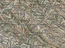
An 1898 map shows the location of Tyrawa Wołoska (click in it to enlarge)
653:
573:
484:
438:
425:
state. Upon the invasion of the
Hungarian tribes into the heart of the
395:
320:
367:
324:
238:
532:
415:
391:
387:
363:
347:
299:
464:
577:
15:
444:
This area was mentioned for the first time in 981, when
636:
611:
286:
281:
273:
265:
260:
252:
244:
226:
123:
46:. Unsourced material may be challenged and removed.
330:The community is about 40 miles (64 km) from
589:
483:), while during 1772-1867 it belonged to the
479:From 1340 to 1772 Tyrawa was part of Poland (
8:
421:The region subsequently became part of the
596:
582:
574:
120:
118:Place in Subcarpathian Voivodship, Poland
106:Learn how and when to remove this message
386:times by various tribes, including the
280:
272:
259:
251:
225:
190:
159:
141:
129:
173:
285:
264:
243:
7:
44:adding citations to reliable sources
269:68.8 km (26.6 sq mi)
14:
499:. In 1918 it returned to Poland.
627:
311:
231:
172:
165:
146:
131:
20:
362:(10 miles (16 km) east of
358:(1975-1998) and is part of the
31:needs additional citations for
487:empire, and from 1867–1918 to
1:
354:(since 1999), previously the
410:), the area was invaded by
711:
277:340 m (1,120 ft)
625:
502:The region was under the
294:
191:
160:
142:
130:
695:Villages in Sanok County
517:Ukrainian Insurgent Army
493:Subcarpathian Voivodship
352:Subcarpathian Voivodship
248:Subcarpathian Voivodship
137:Church of Saint Nicholas
342:highway that goes from
538:
537:Tyrawa Wołoska in 2007
305:
536:
454:Casimir III of Poland
303:
605:Gmina Tyrawa Wołoska
523:") and moved to the
481:Ruthenian Voivodship
350:. It belongs to the
40:improve this article
467:Peter (Petrus) the
446:Volodymyr the Great
382:was overrun in pre-
207: /
539:
511:After World War II
370:: Tyrawa Woloska.
306:
287: • Total
266: • Total
682:
681:
521:Operation Vistula
356:Krosno Voivodship
298:
297:
211:49.583°N 22.367°E
116:
115:
108:
90:
702:
631:
598:
591:
584:
575:
504:Magdeburg rights
429:around 899, the
315:is a village in
314:
237:
235:
234:
222:
221:
219:
218:
217:
212:
208:
205:
204:
203:
200:
176:
175:
169:
150:
135:
121:
111:
104:
100:
97:
91:
89:
55:"Tyrawa Wołoska"
48:
24:
16:
710:
709:
705:
704:
703:
701:
700:
699:
685:
684:
683:
678:
632:
623:
607:
602:
560:Fastnacht, Adam
556:
544:
513:
495:) was known as
489:Austria-Hungary
477:
376:
336:Słonne Mountain
317:East Małopolska
232:
230:
215:
213:
209:
206:
201:
198:
196:
194:
193:
187:
186:
185:
184:
183:
182:
181:
177:
156:
155:
154:
153:
138:
126:
119:
112:
101:
95:
92:
49:
47:
37:
25:
12:
11:
5:
708:
706:
698:
697:
687:
686:
680:
679:
677:
676:
674:Wola Krecowska
671:
666:
661:
656:
651:
646:
640:
638:
637:Other villages
634:
633:
626:
624:
622:
621:
619:Tyrawa Wołoska
615:
613:
609:
608:
603:
601:
600:
593:
586:
578:
572:
571:
555:
552:
551:
550:
543:
540:
512:
509:
476:
473:
456:recovered it.
423:Great Moravian
375:
372:
309:Tyrawa Wołoska
296:
295:
292:
291:
288:
284:
283:
279:
278:
275:
271:
270:
267:
263:
262:
258:
257:
254:
250:
249:
246:
242:
241:
228:
224:
223:
216:49.583; 22.367
189:
188:
180:Tyrawa Woloska
179:
178:
171:
170:
164:
163:
162:
161:
158:
157:
151:
145:
144:
143:
140:
139:
136:
128:
127:
125:Tyrawa Woloska
124:
117:
114:
113:
28:
26:
19:
13:
10:
9:
6:
4:
3:
2:
707:
696:
693:
692:
690:
675:
672:
670:
667:
665:
662:
660:
657:
655:
652:
650:
647:
645:
642:
641:
639:
635:
630:
620:
617:
616:
614:
610:
606:
599:
594:
592:
587:
585:
580:
579:
576:
569:
568:83-88385-14-3
565:
561:
558:
557:
553:
549:
548:Jacob Avigdor
546:
545:
541:
535:
531:
528:
526:
522:
518:
510:
508:
505:
500:
498:
494:
490:
486:
482:
475:Varied rulers
474:
472:
470:
466:
462:
457:
455:
451:
447:
442:
440:
436:
432:
428:
427:Great Moravia
424:
419:
417:
413:
409:
405:
401:
397:
393:
389:
385:
381:
373:
371:
369:
365:
361:
357:
353:
349:
345:
341:
337:
333:
328:
326:
323:mountains of
322:
321:Lesser Beskid
318:
313:
310:
302:
293:
289:
276:
268:
255:
247:
240:
229:
220:
192:Coordinates:
168:
149:
134:
122:
110:
107:
99:
88:
85:
81:
78:
74:
71:
67:
64:
60:
57: –
56:
52:
51:Find sources:
45:
41:
35:
34:
29:This article
27:
23:
18:
17:
618:
529:
514:
501:
478:
458:
443:
420:
377:
360:Sanok County
329:
308:
307:
152:Coat of arms
102:
93:
83:
76:
69:
62:
50:
38:Please help
33:verification
30:
380:Podkarpacie
214: /
669:Siemuszowa
554:References
542:Personalia
461:Wallachian
450:Kievan Rus
412:Hungarians
282:Population
66:newspapers
644:Hołuczków
525:Pomerania
400:Przeworsk
274:Elevation
96:June 2012
689:Category
664:Rozpucie
485:Austrian
431:Lendians
344:Przemyśl
340:Nr. DK28
654:Lachawa
497:Galicia
439:Hungary
396:Vandals
374:Origins
366:); its
332:Rzeszów
319:in the
253:Founded
227:Country
202:22°22′E
199:49°35′N
80:scholar
659:Rakowa
649:Kreców
566:
404:Puchov
368:parish
325:Poland
245:Region
239:Poland
236:
82:
75:
68:
61:
53:
469:Czech
416:Slavs
398:(the
392:Goths
388:Celts
384:Roman
364:Sanok
348:Sanok
290:1,950
87:JSTOR
73:books
612:Seat
564:ISBN
465:Vogt
437:and
414:and
402:and
394:and
261:Area
256:1402
59:news
448:of
435:Rus
408:San
346:to
42:by
691::
471:.
441:.
418:.
390:,
327:.
597:e
590:t
583:v
570:.
109:)
103:(
98:)
94:(
84:·
77:·
70:·
63:·
36:.
Text is available under the Creative Commons Attribution-ShareAlike License. Additional terms may apply.