56:
78:
tribe is also located here. Table Bluff
Rancheria was established in 1908. It originally comprised 20 acres (81,000 m) donated by a local church. An additional 102 acres (0.4 km) were purchased for the tribe by the federal government in 1981 as the result of a lawsuit settlement.
90:
facility at the point of the bluff. The lighthouse was abandoned in 1972 after automated beacons were installed at the
Humboldt Bay entrance. Its entire tower was moved to Woodley Island, across from the Eureka waterfront, in 1987.
101:
8 acres (32,000 m) of the surplus Coast Guard property were purchased by Norman
Kenneth Smith, an evangelical minister, in 1970, and renamed Lighthouse Ranch, which was part of what became an international ministry known as
47:
and 5.5 miles (8.9 km) west of US Highway 101. Table Bluff County Park provides access to the South Spit. The park is also used as a hang-gliding and paragliding staging area. The federally endangered western lily,
71:
was an early resident. Because of its rich soil, Table Bluff has been the site of a small agricultural community since the 1850s. At present, hay fields and cattle ranches occupy most of the bluff.
106:. The "Ranch" became a half-way house for young adults seeking spiritual direction. This ministry later became Gospel Outreach of Eureka. The lighthouse is no longer staffed.
199:
238:
43:
to the south. It overlooks approximately 9,000 acres (36 km) of wildlands administered by various federal and county agencies. It is 12 miles (19 km) south of
94:
In 1970, the Coast Guard cited Seaman Robert Mark for "extraordinary heroism" while serving as crew of CG-44234, for rescuing the operator of the fishing vessel
110:
36:
28:
86:. A fog horn and a Navy wireless telegraphy (later radio) station were in place by 1915 at what eventually became a
103:
87:
67:
Early explorers of the bay called the landform Ridge Point and
Brannan Bluff, but by 1851 Table Bluff had stuck.
157:
40:
32:
83:
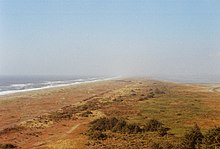
31:, that terminates above the ocean in a dramatic, 165-foot (50 m) high cliff with views of the
49:
44:
190:
185:
20:
232:
113:
began the process of acquiring 5.5 acres (22,000 m) of this property in 2005.
68:
214:
201:
39:, and the Pacific Ocean. It separates Humboldt Bay to the north from the
55:
52:, is found growing on Table Bluff at Table Bluff Ecological Reserve.
75:
54:
161:
124:
The Earth is Our Mother: A Guide to the
Indians of California,
82:
In 1892, a lighthouse was built on the bluff to replace an
8:
239:Landforms of Humboldt County, California
149:
139:California Coastal Conservancy, 2005.
98:which sank just west of Table Bluff.
7:
191:US Coast Guard Medal Award Citations
133:California Coastal Commission, 1987.
14:
131:California Coast Resources Guide,
111:California Coastal Conservancy
1:
137:Lighthouse Ranch Acquisition,
74:A reservation of the native
27:) is a semi-flat terrace in
84:older one on the North Spit
29:Humboldt County, California
255:
35:delta, the South Spit of
158:"Language – Wiyot Tribe"
122:Eargle, Dolan H., Jr.,
215:40.65806°N 124.21639°W
59:
129:Ginsberg, Joanne S.,
58:
220:40.65806; -124.21639
186:Norman Kenneth Smith
211: /
60:
50:Lilium occidentale
246:
226:
225:
223:
222:
221:
216:
212:
209:
208:
207:
204:
173:
172:
170:
169:
160:. Archived from
154:
254:
253:
249:
248:
247:
245:
244:
243:
229:
228:
219:
217:
213:
210:
205:
202:
200:
198:
197:
196:
182:
177:
176:
167:
165:
156:
155:
151:
146:
119:
117:Further reading
104:Gospel Outreach
65:
12:
11:
5:
252:
250:
242:
241:
231:
230:
194:
193:
188:
181:
180:External links
178:
175:
174:
148:
147:
145:
142:
141:
140:
134:
127:
118:
115:
64:
61:
13:
10:
9:
6:
4:
3:
2:
251:
240:
237:
236:
234:
227:
224:
192:
189:
187:
184:
183:
179:
164:on 2012-02-13
163:
159:
153:
150:
143:
138:
135:
132:
128:
125:
121:
120:
116:
114:
112:
107:
105:
99:
97:
92:
89:
85:
80:
77:
72:
70:
62:
57:
53:
51:
46:
42:
38:
34:
30:
26:
22:
18:
195:
166:. Retrieved
162:the original
152:
136:
130:
123:
108:
100:
95:
93:
81:
73:
66:
37:Humboldt Bay
24:
16:
15:
218: /
206:124°12′59″W
88:Coast Guard
69:Seth Kinman
17:Table Bluff
203:40°39′29″N
168:2012-07-07
144:References
41:Eel River
33:Eel River
233:Category
63:History
25:Giloulh
96:Alice,
45:Eureka
126:1986.
76:Wiyot
21:Wiyot
109:The
235::
23::
171:.
19:(
Text is available under the Creative Commons Attribution-ShareAlike License. Additional terms may apply.