373:
45:
29:
310:
52:
340:
The creek starts in
Terraview Willowfield Park, a restoration project, named after a nearby public school. It flows through two medium-sized ponds with naturalized channels. From there it flows southeast through a series of concrete lined channels and drains. This section runs along an abandoned
589:
which calls for a reduction of storm water flow into Taylor-Massey Creek and also recommends a restoration plan that will improve habitat in the creek for fish and other water dwelling organisms. In
September, 2006, The TMP recommended the establishment of a Taylor Massey Watershed Management
384:
exists entirely within an urban setting and has suffered severe degradation. The upper portion of the creek is encased almost entirely in concrete lined channels which increases the flow of the river and provides little habitat. Other sections are constrained by rock filled
590:
Co-ordinator as the best means of implementing Wet
Weather Flow in the watershed, which is a priority under this 25-year, $ 1B plan. The city has also pledged to locate illegal sewer hookups and redirect them into sanitary sewers.
558:
bacteria and other contaminants. Periodic spills from adjacent industrial lands have also increased contamination. Due to the poor water quality and the engineered riverbanks, the creek shows little signs of life.
301:, was originally part of the Massey estate and is now used as the Children's Peace Theatre. The mansion was built in 1921 for Dr. Arthur Goulding and his wife, Dorothy Massey, daughter of Walter and Susan Massey.
196:
297:
farm equipment manufacturing company. Both families had sizable estates in the vicinity of the creek. The Massey
Goulding Estate, a historic property at 305
818:
781:
515:
130:
360:
East. At Warden Avenue it turns southwest, moving through a park called Warden Woods. West of
Pharmacy Avenue it enters a city run golf course. At
364:
it enters Taylor Creek Park and continues uninterrupted to where it empties into the Don River East Branch, just north of the forks of the Don.
541:
510:
479:
282:
811:
342:
676:"Report on Progress and Findings from the Storm Outfall Monitoring Program in Taylor-Massey Creek – July to September 2005"
44:
983:
988:
804:
627:
599:
575:
882:
872:
632:
562:
Several places in the ravine were also once municipal landfills, although all of them have now been shut down.
534:
453:
330:
927:
897:
831:
578:
projects along the creek, as well as along local branches of the East and West Don rivers. FODE created The
571:
505:
957:
892:
474:
286:
353:
922:
917:
847:
827:
579:
322:
389:
baskets. The water is heavily polluted from storm water outfalls that empty directly into the creek.
361:
263:
554:
In June 2005, the city performed a water quality study that revealed the presence of high levels of
912:
886:
862:
527:
412:
372:
326:
251:
181:
703:
662:
622:
877:
857:
422:
417:
796:
952:
651:
932:
555:
357:
902:
867:
489:
484:
443:
349:
937:
469:
381:
791:
786:
675:
345:
before entering a residential and industrial section that is closed to public access.
977:
962:
294:
290:
942:
907:
448:
28:
852:
842:
309:
176:
334:
318:
298:
749:
211:
198:
145:
132:
267:
321:
are near
Sheppard and Victoria Park Avenues. It flowed diagonally through
270:, where it enters the Don River. Taylor-Massey Creek has also been called
725:
792:
Table from outfall report, June 2005: locations of contaminated outfalls
333:
when the highway was widened to 12 lanes, so the creek now starts at a
259:
255:
115:
96:
86:
386:
76:
582:, in 2003, which became a separate organization in November, 2004.
356:. It exits the cemetery travelling west and enters a small park on
371:
308:
352:
East it enters a shallow ravine and flows south passing through
800:
329:
at
Pharmacy Avenue. The original headwaters were diverted to
281:
The creek is named after two prominent
Toronto families. The
787:
Table from outfall report, June 2005: contaminant levels
776:
771:
33:
Taylor-Massey Creek in Warden Woods Park, Scarborough
237:
227:
188:
175:
161:
122:
111:
102:
92:
82:
72:
67:
21:
285:were a wealthy family that owned and operated the
663:Children's Peace Theatre – Massey Goulding Estate
317:Taylor-Massey Creek is 16 kilometres long. Its
674:Di Gironimo, Lou; Anderton, Rod (2005-09-21).
812:
585:In 2003, the City of Toronto implemented the
535:
59:Location of the mouth of the creek in Toronto
8:
51:
819:
805:
797:
542:
528:
391:
516:Toronto and Region Conservation Authority
617:
615:
611:
587:Wet Weather Flow Management Master Plan
497:
461:
435:
404:
399:
704:"Wet Weather Flow Master Plan (WWFMP)"
18:
7:
337:outfall just south of the highway.
14:
570:In 1993, a citizens group called
511:Task Force to Bring Back the Don
50:
43:
27:
752:. Friends of the Don East. 2004
750:"FODE's Taylor Massey Project"
190: • coordinates
124: • coordinates
1:
118:in Terraview Willowfield Park
103:Physical characteristics
628:Geographical Names Data Base
229: • elevation
163: • elevation
731:. The Taylor Massey Project
724:Penny, Nancy (2006-09-04).
1005:
313:Terraview Willowfield Park
838:
600:List of rivers of Ontario
576:environmental restoration
171:
107:
38:
26:
633:Natural Resources Canada
380:The Taylor-Massey Creek
241:16 km (9.9 mi)
167:169 m (554 ft)
832:Toronto waterway system
782:1878 Map of Scarborough
772:Friends of the Don East
572:Friends of the Don East
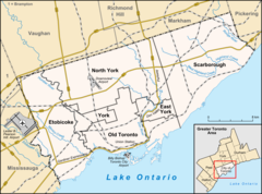
506:Friends of the Don East
395:Part of a series on the
233:86 m (282 ft)
652:Massey-Goulding Estate
475:Don Valley Brick Works
377:
314:
287:Don Valley Brick Works
250:is a tributary of the
828:Toronto ravine system
777:Taylor Massey Project
580:Taylor Massey Project
375:
312:
212:43.70333°N 79.33306°W
146:43.76667°N 79.31306°W
362:Victoria Park Avenue
984:Don River (Ontario)
948:Taylor-Massey Creek
887:West Highland Creek
566:Restoration efforts
428:Taylor-Massey Creek
354:Pine Hills Cemetery
262:. It flows through
248:Taylor-Massey Creek
217:43.70333; -79.33306
208: /
151:43.76667; -79.31306
142: /
22:Taylor-Massey Creek
878:German Mills Creek
858:Castle Frank Brook
423:German Mills Creek
418:Castle Frank Brook
378:
315:
989:Rivers of Toronto
971:
970:
706:. City of Toronto
685:. City of Toronto
552:
551:
376:Channelized Creek
323:Wishing Well Park
245:
244:
996:
821:
814:
807:
798:
760:
758:
757:
740:
739:
737:
736:
730:
721:
715:
714:
712:
711:
700:
694:
693:
691:
690:
680:
671:
665:
660:
654:
649:
643:
642:
640:
639:
619:
544:
537:
530:
392:
358:St. Clair Avenue
223:
222:
220:
219:
218:
213:
209:
206:
205:
204:
201:
164:
157:
156:
154:
153:
152:
147:
143:
140:
139:
138:
135:
125:
54:
53:
47:
31:
19:
1004:
1003:
999:
998:
997:
995:
994:
993:
974:
973:
972:
967:
903:Keating Channel
868:Etobicoke Creek
834:
825:
768:
763:
755:
753:
748:
744:
743:
734:
732:
728:
723:
722:
718:
709:
707:
702:
701:
697:
688:
686:
678:
673:
672:
668:
661:
657:
650:
646:
637:
635:
621:
620:
613:
608:
596:
568:
548:
490:Todmorden Mills
485:Charles Sauriol
444:Edwards Gardens
370:
350:Eglinton Avenue
307:
230:
216:
214:
210:
207:
202:
199:
197:
195:
194:
191:
162:
150:
148:
144:
141:
136:
133:
131:
129:
128:
123:
63:
62:
61:
60:
57:
56:
55:
34:
17:
16:River in Canada
12:
11:
5:
1002:
1000:
992:
991:
986:
976:
975:
969:
968:
966:
965:
960:
955:
953:Tomlin's Creek
950:
945:
940:
938:Superior Creek
935:
930:
925:
920:
915:
910:
905:
900:
895:
890:
883:Highland Creek
880:
875:
873:Garrison Creek
870:
865:
860:
855:
850:
845:
839:
836:
835:
826:
824:
823:
816:
809:
801:
795:
794:
789:
784:
779:
774:
767:
766:External links
764:
762:
761:
745:
742:
741:
716:
695:
666:
655:
644:
623:"Taylor Creek"
610:
609:
607:
604:
603:
602:
595:
592:
567:
564:
550:
549:
547:
546:
539:
532:
524:
521:
520:
519:
518:
513:
508:
500:
499:
495:
494:
493:
492:
487:
482:
477:
472:
470:Crothers Woods
464:
463:
459:
458:
457:
456:
454:Riverdale Park
451:
446:
438:
437:
433:
432:
431:
430:
425:
420:
415:
407:
406:
402:
401:
397:
396:
369:
366:
331:Highland Creek
306:
303:
276:Scarboro Creek
243:
242:
239:
235:
234:
231:
228:
225:
224:
192:
189:
186:
185:
179:
173:
172:
169:
168:
165:
159:
158:
126:
120:
119:
113:
109:
108:
105:
104:
100:
99:
94:
90:
89:
84:
80:
79:
74:
70:
69:
65:
64:
58:
49:
48:
42:
41:
40:
39:
36:
35:
32:
24:
23:
15:
13:
10:
9:
6:
4:
3:
2:
1001:
990:
987:
985:
982:
981:
979:
964:
963:Wendigo Creek
961:
959:
956:
954:
951:
949:
946:
944:
941:
939:
936:
934:
933:Small's Creek
931:
929:
928:Russell Creek
926:
924:
921:
919:
916:
914:
911:
909:
906:
904:
901:
899:
898:Jackson Creek
896:
894:
891:
888:
884:
881:
879:
876:
874:
871:
869:
866:
864:
861:
859:
856:
854:
851:
849:
846:
844:
841:
840:
837:
833:
829:
822:
817:
815:
810:
808:
803:
802:
799:
793:
790:
788:
785:
783:
780:
778:
775:
773:
770:
769:
765:
751:
747:
746:
727:
720:
717:
705:
699:
696:
684:
677:
670:
667:
664:
659:
656:
653:
648:
645:
634:
630:
629:
624:
618:
616:
612:
605:
601:
598:
597:
593:
591:
588:
583:
581:
577:
574:(FODE) began
573:
565:
563:
560:
557:
545:
540:
538:
533:
531:
526:
525:
523:
522:
517:
514:
512:
509:
507:
504:
503:
502:
501:
496:
491:
488:
486:
483:
481:
478:
476:
473:
471:
468:
467:
466:
465:
460:
455:
452:
450:
447:
445:
442:
441:
440:
439:
434:
429:
426:
424:
421:
419:
416:
414:
411:
410:
409:
408:
403:
398:
394:
393:
390:
388:
383:
374:
367:
365:
363:
359:
355:
351:
346:
344:
338:
336:
332:
328:
324:
320:
311:
304:
302:
300:
296:
295:Massey-Harris
292:
291:Massey family
288:
284:
279:
277:
273:
269:
265:
261:
257:
253:
249:
240:
236:
232:
226:
221:
193:
187:
183:
180:
178:
174:
170:
166:
160:
155:
127:
121:
117:
114:
110:
106:
101:
98:
95:
91:
88:
85:
81:
78:
75:
71:
66:
46:
37:
30:
25:
20:
958:Yellow Creek
947:
943:Taddle Creek
908:Mimico Creek
893:Humber River
754:. Retrieved
733:. Retrieved
719:
708:. Retrieved
698:
687:. Retrieved
683:Staff Report
682:
669:
658:
647:
636:. Retrieved
626:
586:
584:
569:
561:
553:
449:Milne Hollow
427:
379:
347:
343:right-of-way
339:
316:
280:
275:
272:Silver Creek
271:
247:
246:
93:Municipality
923:Rouge River
918:North Creek
853:Burke Brook
848:Black Creek
843:Bonar Creek
498:Environment
480:John Taylor
327:Highway 401
305:Description
264:Scarborough
215: /
184:east branch
149: /
978:Categories
756:2006-06-07
735:2009-06-26
710:2006-06-07
689:2006-06-07
638:2018-07-03
606:References
400:Don Valley
335:stormwater
325:and under
319:headwaters
299:Dawes Road
293:owned the
203:79°19′59″W
200:43°42′12″N
137:79°18′47″W
134:43°46′00″N
913:Mud Creek
863:Don River
413:Don River
382:watershed
348:South of
268:East York
252:Don River
182:Don River
726:"Letter"
594:See also
368:Problems
83:Province
68:Location
556:E. coli
462:History
283:Taylors
260:Ontario
256:Toronto
116:Culvert
97:Toronto
87:Ontario
73:Country
405:Rivers
387:gabion
341:hydro
289:. The
238:Length
112:Source
77:Canada
729:(PDF)
679:(PDF)
436:Parks
177:Mouth
274:and
266:and
254:in
980::
681:.
631:.
625:.
614:^
278:.
258:,
889:)
885:(
830:/
820:e
813:t
806:v
759:.
738:.
713:.
692:.
641:.
543:e
536:t
529:v
Text is available under the Creative Commons Attribution-ShareAlike License. Additional terms may apply.