58:
220:
359:
65:
371:
87:
45:
347:
198:
In the park there are several endangered species such as the front and jaguar bear, other mammals such as cachicamos, lapas, rabipelados, monkeys araguatos, capuchin monkeys, mapurites, cunaguaros, deer, dantas, bears meleros, pumas and báquiros.
194:
Its temperature varies between 19 and 26 degrees
Celsius. Its vegetation in the highest parts is of cloud forest with the presence of trees such as mountaineers, salvio and mountain manzanita, as well as several species of ferns.
57:
403:
771:
776:
756:
525:
472:
781:
396:
191:
It was decreed
National Park on April 14, 1976, with the purpose of protecting the flora and fauna of the region. It has an area of 18,971 hectares.
766:
715:
535:
692:
437:
104:
568:
751:
389:
644:
634:
412:
255:Áreas importantes para la conservación de las aves en los Andes tropicales: sitios prioritarios para la conservación de la biodiversidad
208:
761:
687:
682:
677:
601:
424:
323:
293:
263:
467:
462:
558:
530:
30:
510:
442:
720:
563:
550:
596:
432:
188:, capital of the Lara State, it covers areas belonging to the municipalities Iribarren, Palavecino and Simón Planas.
649:
337:
219:
240:
746:
707:
659:
621:
611:
586:
578:
540:
313:
253:
520:
502:
515:
487:
492:
452:
697:
457:
725:
667:
639:
629:
606:
591:
213:
482:
447:
672:
363:
319:
289:
285:
259:
375:
358:
351:
181:
165:
172:) Is a protected area with the status of national park in the South American country of
16:
National park in the
Venezuelan municipalities of Iribarren, Palavecino and Simón Planas
740:
279:
34:
185:
177:
381:
119:
106:
416:
173:
92:
44:
252:
Boyla, Kerem; Estrada, Angélica; International, BirdLife (2017-03-15).
218:
385:
335:
706:
658:
620:
577:
549:
501:
423:
143:
135:
98:
80:
21:
64:
184:States. Specifically southeast of the city of
397:
281:IUCN Directory of Neotropical Protected Areas
8:
473:Juan Crisóstomo Falcón, Sierra de San Luis
404:
390:
382:
18:
772:Tourist attractions in Portuguesa (state)
318:(in Spanish). Fundación Eugenio Mendoza.
176:located in the mountainous region of the
342:
233:
258:(in Spanish). BirdLife International.
438:Ciénagas de Juan Manuel/del Catatumbo
7:
139:186.5 km (72.0 sq mi)
79:
777:Tourist attractions in Lara (state)
757:Protected areas established in 1976
209:List of national parks of Venezuela
14:
782:1976 establishments in Venezuela
521:General Cruz Carrillo/Guaramacal
369:
357:
345:
85:
63:
56:
43:
767:Geography of Portuguesa (state)
315:Venezuela: opciones geográficas
142:
483:Tirgua General Manuel Manrique
1:
443:Cueva de la Quebrada del Toro
312:Cunill, Pedro (1990-01-01).
284:. IUCN. 1982-01-01. p.
752:National parks of Venezuela
526:General Juan Pablo Peñaloza
798:
300:Parque nacional Terepaima.
762:Geography of Lara (state)
630:Mariusa/Delta del Orinoco
241:Parque nacional Terepaima
170:Parque nacional Terepaima
51:
42:
28:
24:Parque Nacional Terepaima
147:April 14, 1976
716:Archipiélago Los Roques
162:Terepaima National Park
22:Terepaima National Park
693:Serranía de la Neblina
224:
169:
726:Laguna de la Restinga
222:
214:Mochima National Park
569:Río Viejo San Camilo
673:Caura National Park
602:Laguna de Tacarigua
116: /
645:Península de Paria
635:Cueva del Guácharo
225:
734:
733:
688:Parima Tapirapecó
683:Jaua-Sarisariñama
660:Region of Guayana
559:Aguaro-Guariquito
425:Western Venezuela
158:
157:
789:
747:IUCN Category II
531:Sierra La Culata
503:Venezuelan Andes
468:Sierra de Perijá
406:
399:
392:
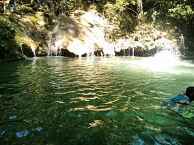
383:
374:
373:
372:
362:
361:
350:
349:
348:
341:
330:
329:
309:
303:
302:
276:
270:
269:
249:
243:
238:
154:
152:
131:
130:
128:
127:
126:
121:
120:9.867°N 69.267°W
117:
114:
113:
112:
109:
91:
89:
88:
67:
66:
60:
47:
19:
797:
796:
792:
791:
790:
788:
787:
786:
737:
736:
735:
730:
702:
678:Duida-Marahuaca
654:
616:
573:
545:
511:Chorro El Indio
497:
463:Médanos de Coro
419:
410:
380:
370:
368:
356:
346:
344:
336:
334:
333:
326:
311:
310:
306:
296:
278:
277:
273:
266:
251:
250:
246:
239:
235:
230:
205:
150:
148:
124:
122:
118:
115:
110:
107:
105:
103:
102:
86:
84:
76:
75:
74:
73:
70:
69:
68:
38:
23:
17:
12:
11:
5:
795:
793:
785:
784:
779:
774:
769:
764:
759:
754:
749:
739:
738:
732:
731:
729:
728:
723:
721:Cerro El Copey
718:
712:
710:
704:
703:
701:
700:
695:
690:
685:
680:
675:
670:
664:
662:
656:
655:
653:
652:
647:
642:
637:
632:
626:
624:
622:Eastern Region
618:
617:
615:
614:
609:
604:
599:
594:
589:
583:
581:
579:Central Region
575:
574:
572:
571:
566:
564:Santos Luzardo
561:
555:
553:
547:
546:
544:
543:
538:
533:
528:
523:
518:
513:
507:
505:
499:
498:
496:
495:
490:
485:
480:
475:
470:
465:
460:
455:
450:
445:
440:
435:
429:
427:
421:
420:
413:National parks
411:
409:
408:
401:
394:
386:
379:
378:
366:
354:
332:
331:
324:
304:
294:
271:
264:
244:
232:
231:
229:
226:
217:
216:
211:
204:
201:
156:
155:
145:
141:
140:
137:
133:
132:
125:9.867; -69.267
100:
96:
95:
82:
78:
77:
71:
62:
61:
55:
54:
53:
52:
49:
48:
40:
39:
29:
26:
25:
15:
13:
10:
9:
6:
4:
3:
2:
794:
783:
780:
778:
775:
773:
770:
768:
765:
763:
760:
758:
755:
753:
750:
748:
745:
744:
742:
727:
724:
722:
719:
717:
714:
713:
711:
709:
705:
699:
696:
694:
691:
689:
686:
684:
681:
679:
676:
674:
671:
669:
666:
665:
663:
661:
657:
651:
648:
646:
643:
641:
638:
636:
633:
631:
628:
627:
625:
623:
619:
613:
610:
608:
605:
603:
600:
598:
597:Henri Pittier
595:
593:
590:
588:
585:
584:
582:
580:
576:
570:
567:
565:
562:
560:
557:
556:
554:
552:
548:
542:
539:
537:
536:Sierra Nevada
534:
532:
529:
527:
524:
522:
519:
517:
514:
512:
509:
508:
506:
504:
500:
494:
491:
489:
486:
484:
481:
479:
476:
474:
471:
469:
466:
464:
461:
459:
456:
454:
451:
449:
446:
444:
441:
439:
436:
434:
433:Cerro Saroche
431:
430:
428:
426:
422:
418:
414:
407:
402:
400:
395:
393:
388:
387:
384:
377:
367:
365:
360:
355:
353:
343:
339:
327:
325:9789806017481
321:
317:
316:
308:
305:
301:
297:
295:9780907567622
291:
287:
283:
282:
275:
272:
267:
265:9789978441961
261:
257:
256:
248:
245:
242:
237:
234:
227:
221:
215:
212:
210:
207:
206:
202:
200:
196:
192:
189:
187:
183:
179:
175:
171:
167:
163:
146:
138:
134:
129:
101:
97:
94:
83:
59:
50:
46:
41:
36:
35:national park
32:
31:IUCN category
27:
20:
477:
314:
307:
299:
280:
274:
254:
247:
236:
223:Another view
197:
193:
190:
186:Barquisimeto
161:
159:
612:San Esteban
541:Tapo-Caparo
364:Environment
144:Established
123: /
99:Coordinates
741:Categories
551:Los Llanos
228:References
182:Portuguesa
151:1976-04-14
650:Turuépano
478:Terepaima
453:El Guache
417:Venezuela
376:Venezuela
352:Geography
174:Venezuela
93:Venezuela
708:Offshore
698:Yapacana
587:El Ávila
458:Morrocoy
203:See also
81:Location
72:Location
668:Canaima
640:Mochima
607:Macarao
592:Guatopo
516:El Tamá
488:Yacambú
338:Portals
166:Spanish
149: (
111:69°16′W
493:Yurubí
448:Dinira
322:
292:
262:
108:9°52′N
90:
320:ISBN
290:ISBN
260:ISBN
180:and
178:Lara
160:The
136:Area
33:II (
415:of
286:395
743::
298:.
288:.
168::
405:e
398:t
391:v
340::
328:.
268:.
164:(
153:)
37:)
Text is available under the Creative Commons Attribution-ShareAlike License. Additional terms may apply.