612:
462:, completed in 1938, the USACE looked to develop another hydro power production facility on the Columbia River. The Dalles' location on the mid-Columbia River below the falls made it an ideal hydro power production site. The Dalles Dam was authorized under the 1950 Flood Control Act, with the federal government able to work around the treaty with local tribes by paying them a settlement. However, despite assurances from the USACE that they would work to improve living conditions in Celilo as part of the settlement, these efforts failed for lack of attention by the federal government.
34:
487:
568:
1366:
596:
1390:
584:
1378:
1341:
477:
survey of the riverbed of Celilo Falls to determine whether the former site of the falls had been destroyed by the construction of the dam. The survey found that the geological features on the riverbed match those observed in photos of the falls prior to the construction of the dam. Hypothetically,
465:
Since 2016, the USACE has worked on The Dalles Lock & Dam Tribal
Housing Village Development Plan. This plan is designed to find a location for and construct a village for members of the tribes that historically relied on Celilo Falls for fishing. The Village Development Plan had been slated to
442:
Prior to the construction of the dam, Celilo Falls was a hub for local Native
American trading and fishing. The area served as a spiritual monument as well, and continues to be the site of traditional ceremonies, during which people celebrate the end of winter and the beginning of the spring
611:
418:
450:
The construction of the Dalles Dam was extremely damaging to salmon runs in the
Columbia River. The physical dam makes it difficult for fish to navigate the river and reach their spawning grounds. Even with the installation of
895:
1440:
636:
1014:
1430:
466:
be finished by fall of 2020, however, as of April 2023 it has not been completed. In 2017, various senators from the states of Oregon and
Washington signed a letter to the Director of the
419:
420:
595:
1445:
1455:
1460:
458:
Celilo Falls and the traditional rights of local Native
American tribes to fish were protected by a government treaty, but with the onset of the Cold War and the legacy of
1485:
72:
880:
422:
1470:
398:
567:
1490:
1435:
1192:
1130:
1201:
631:
402:
344:
On March 10, 1957, hundreds of observers looked on as the rising waters rapidly silenced the falls, submerged fishing platforms, and consumed the village of
401:. Along with hydro power, the dam provides irrigation water, flood mitigation, navigation, and recreation. The Dalles Lock and Dam has been designated as a
795:
1073:
1048:
1007:
1450:
376:
1298:
1475:
955:
1126:
427:
326:
1077:
682:
421:
1425:
1420:
985:
406:
394:
security concerns, and partly due to deteriorating track conditions and a small derailment. The
Columbia Hills State Park is nearby.
1185:
931:
275:
978:"Portland District > Missions > Tribal Relationships > The Dalles Lock & Dam Tribal Housing Village Development Plan"
857:
737:
1465:
467:
372:
141:
835:
1410:
1356:
1178:
314:
291:
135:
55:
1122:
660:
353:
1319:
1081:
1040:
1415:
1394:
352:
panels were removed with jackhammers before inundation and were placed in storage before being installed in
435:
345:
303:
1480:
829:
583:
33:
1155:
1370:
391:
287:
59:
947:
307:
486:
776:
299:
283:
245:
334:
689:
1335:
1261:
1161:
927:
807:
977:
1236:
1231:
768:
491:
1170:
1251:
1246:
1226:
295:
1302:
1281:
1221:
1205:
459:
279:
257:
1404:
849:
780:
729:
574:
501:
Height: 200 feet (61 m) (Lake Celilo normal pool elevation 158 feet (48 m))
390:
shore, was built in 1981. A tour train was closed in autumn 2001, partly due to post-
330:
263:
235:
1382:
1271:
431:
383:
368:
322:
1292:
1389:
1256:
452:
364:
318:
215:
1266:
602:
444:
349:
348:. Ancient petroglyphs were also in the area being submerged. Approximately 40
811:
88:
74:
1377:
1241:
478:
this establishes that the falls would return if the dam were to be removed.
434:
in 1956, shortly before the site was submerged by the Dalles Dam (35 sec.) (
360:
772:
1216:
317:(USACE) began work on the dam in 1952 and completed it five years later.
881:"The Dalles Dam – An ASCE National Historic Civil Engineering Landmark"
338:
656:
601:
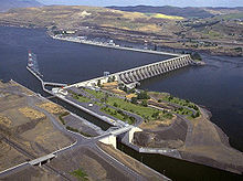
Looking west, fish ladder in the foreground, power generation center.
294:, 192 miles (309 km) upriver from the mouth of the Columbia near
759:
Hunn, Eugene S. (Winter 2007). "Sk'in, The Other Side of the River".
387:
371:. The dam is operated by the USACE, and the power is marketed by the
367:
and runs 24 miles (39 km) up the river channel, to the foot of
1340:
474:
470:, expressing concern about the Office's plan to halt the project.
329:
in the region and the oldest continuously inhabited settlement in
637:
List of largest hydroelectric power stations in the United States
1296:
1174:
657:"Carbon Monitoring for Action | Center For Global Development"
157:
917:
915:
913:
718:. Seattle, WA: University of Washington Press. p. 52.
1441:
Buildings and structures in
Klickitat County, Washington
1162:"The Dalles Dam to Submerge Famous Indian Fishing Spot."
550:
Capacity: 2,290,000 cu ft/s (65,000 m/s)
1354:
1039:
Joe Rojas-Burke, The
Oregonian (November 28, 2008).
821: – via EBSCO's Master File Complete
256:
244:
234:
229:
221:
211:
206:
198:
190:
182:
174:
166:
156:
151:
128:
120:
112:
66:
51:
43:
26:
1158: – The U.S. Army Corps of Engineers
1431:Hydroelectric power plants in Washington (state)
333:. Inhabitants of the submerged area include the
926:. University of Washington Press. p. 272.
399:largest hydroelectric dams in the United States
1446:Buildings and structures in The Dalles, Oregon
282:, two miles (3.2 km) east of the city of
1186:
577:speaking at The Dalles Dam dedication in 1959
498:Altitude: 79 feet (24 m) above sea level
202:2,290,000 cu ft/s (65,000 m/s)
8:
632:List of dams in the Columbia River watershed
403:National Historic Civil Engineering Landmark
375:(BPA). It is part of an extensive system of
1456:Tourist attractions in Wasco County, Oregon
716:Northwest Passage: The Great Columbia River
490:Tributaries of the Columbia River, showing
1461:United States Army Corps of Engineers dams
1293:
1193:
1179:
1171:
32:
23:
16:US hydroelectric dam on the Columbia River
1486:1957 establishments in Washington (state)
794:Banyasz, Malin Grunberg (May–June 2017).
688:. BPA.gov. pp. 14–15. Archived from
683:"The Columbia River System Inside Story"
485:
416:
1471:Energy infrastructure completed in 1957
1361:
1068:
1066:
1020:from the original on September 20, 2022
879:Goodell, Christopher R. (Spring 2014).
648:
563:
1117:
1115:
1113:
1111:
1109:
1107:
1105:
1103:
1101:
1099:
988:from the original on December 16, 2022
958:from the original on December 16, 2022
898:from the original on November 24, 2021
827:
1133:from the original on October 20, 2020
1127:United States Army Corps of Engineers
1041:"Sonar shows Celilo Falls are intact"
455:, salmon populations have struggled.
413:Environmental and social consequences
377:dams on the Columbia and Snake Rivers
7:
1491:Historic Civil Engineering Landmarks
1436:Hydroelectric power plants in Oregon
1123:"The Dalles Lock and Dam Fact Sheet"
1078:National Performance of Dams Program
1051:from the original on October 2, 2023
948:"Bonneville Dam and Lake Bonneville"
740:from the original on October 2, 2023
922:Barber, Katrine (January 1, 2005).
663:from the original on March 18, 2014
407:American Society of Civil Engineers
325:, the economic and cultural hub of
225:330,000 acre⋅ft (0.41 km)
860:from the original on April 7, 2016
382:The Dalles Dam Visitor Center, in
186:239 ft (73 m) (Spillway)
162:Concrete gravity, run-of-the-river
14:
533:Total capacity: 1,878.3 megawatts
504:Length: 8,835 feet (2,693 m)
397:The Dalles Dam is one of the ten
1388:
1376:
1364:
1339:
610:
594:
582:
566:
1451:Run-of-the-river power stations
1167:, April 1956, pp. 138–140.
547:Length: 1,447 feet (441 m)
524:Length: 2,089 feet (637 m)
473:In 2007, the USACE conducted a
468:Office of Management and Budget
373:Bonneville Power Administration
142:Bonneville Power Administration
527:Fourteen 94,400 kilowatt units
1:
1476:1957 establishments in Oregon
1311:
321:created by the dam submerged
530:Eight 104,000 kilowatt units
315:U.S. Army Corps of Engineers
292:Klickitat County, Washington
178:8,835 ft (2,693 m)
136:U.S. Army Corps of Engineers
56:Klickitat County, Washington
761:Oregon Historical Quarterly
617:The Dalles Dam in June 1973
536:Overload capacity: 2,160 MW
298:. The closest towns on the
1507:
1426:Dams on the Columbia River
1421:Dams in Washington (state)
834:: CS1 maint: postscript (
714:Dietrich, William (1995).
516:675 feet (206 m) long
286:, United States. It joins
1330:
1324:
1314:
1309:
1212:
1156:The Dalles Lock & Dam
1074:"The Dalles Lock and Dam"
924:The Death of Celilo Falls
854:The Dalles Dam Tour Train
354:Columbia Hills State Park
31:
1320:Oregon Trunk Rail Bridge
605:rises in the background.
589:The Dalles Dam site plan
513:86 feet (26 m) wide
363:behind the dam is named
194:Service, gate-controlled
38:From the Washington side
823:(subscription required)
272:The Dalles Lock and Dam
246:Installed capacity
170:200 ft (61 m)
113:Construction began
47:The Dalles Lock and Dam
27:The Dalles Lock and Dam
1466:Dams completed in 1957
982:www.nwp.usace.army.mil
952:www.nwd.usace.army.mil
730:"Celilo Falls, Oregon"
494:
439:
274:is a concrete-gravity
258:Annual generation
199:Spillway capacity
89:45.61361°N 121.13333°W
773:10.1353/ohq.2007.0028
734:National Park Service
489:
425:
158:Type of dam
1411:Columbia River Gorge
426:Newsreel footage of
288:Wasco County, Oregon
94:45.61361; -121.13333
60:Wasco County, Oregon
222:Total capacity
84: /
21:Dam in Oregon, U.S.
1202:Hydroelectric dams
495:
492:hydroelectric dams
440:
284:The Dalles, Oregon
191:Spillway type
1352:
1351:
1347:
1346:
1336:The Dalles Bridge
1290:
1289:
1165:Popular Mechanics
507:Navigation lock:
423:
278:dam spanning the
269:
268:
183:Width (base)
152:Dam and spillways
121:Opening date
1498:
1395:Renewable energy
1393:
1392:
1381:
1380:
1369:
1368:
1367:
1360:
1343:
1312:
1294:
1195:
1188:
1181:
1172:
1143:
1142:
1140:
1138:
1119:
1094:
1093:
1091:
1089:
1084:on March 7, 2016
1080:. Archived from
1070:
1061:
1060:
1058:
1056:
1036:
1030:
1029:
1027:
1025:
1019:
1012:
1004:
998:
997:
995:
993:
974:
968:
967:
965:
963:
944:
938:
937:
919:
908:
907:
905:
903:
885:
876:
870:
869:
867:
865:
846:
840:
839:
833:
825:
824:
820:
818:
791:
785:
784:
756:
750:
749:
747:
745:
736:. May 10, 2023.
726:
720:
719:
711:
705:
704:
702:
700:
694:
687:
679:
673:
672:
670:
668:
653:
614:
598:
586:
570:
424:
327:Native Americans
276:run-of-the-river
108:
107:
105:
104:
103:
101:
96:
95:
90:
85:
82:
81:
80:
77:
36:
24:
1506:
1505:
1501:
1500:
1499:
1497:
1496:
1495:
1401:
1400:
1399:
1387:
1375:
1365:
1363:
1355:
1353:
1348:
1338:
1334:
1328:
1322:
1318:
1305:
1291:
1286:
1208:
1199:
1152:
1147:
1146:
1136:
1134:
1121:
1120:
1097:
1087:
1085:
1072:
1071:
1064:
1054:
1052:
1038:
1037:
1033:
1023:
1021:
1017:
1010:
1006:
1005:
1001:
991:
989:
976:
975:
971:
961:
959:
946:
945:
941:
934:
921:
920:
911:
901:
899:
883:
878:
877:
873:
863:
861:
848:
847:
843:
826:
822:
816:
814:
793:
792:
788:
758:
757:
753:
743:
741:
728:
727:
723:
713:
712:
708:
698:
696:
695:on May 27, 2010
692:
685:
681:
680:
676:
666:
664:
655:
654:
650:
645:
628:
623:
622:
621:
618:
615:
606:
599:
590:
587:
578:
573:Vice-President
571:
559:
484:
417:
415:
296:Astoria, Oregon
251:
147:
99:
97:
93:
91:
87:
86:
83:
78:
75:
73:
71:
70:
39:
22:
17:
12:
11:
5:
1504:
1502:
1494:
1493:
1488:
1483:
1478:
1473:
1468:
1463:
1458:
1453:
1448:
1443:
1438:
1433:
1428:
1423:
1418:
1416:Dams in Oregon
1413:
1403:
1402:
1398:
1397:
1385:
1373:
1350:
1349:
1345:
1344:
1329:
1326:The Dalles Dam
1323:
1310:
1307:
1306:
1303:Columbia River
1297:
1288:
1287:
1285:
1284:
1279:
1274:
1269:
1264:
1259:
1254:
1249:
1244:
1239:
1234:
1229:
1224:
1219:
1213:
1210:
1209:
1206:Columbia River
1200:
1198:
1197:
1190:
1183:
1175:
1169:
1168:
1159:
1151:
1150:External links
1148:
1145:
1144:
1095:
1062:
1031:
999:
969:
939:
932:
909:
871:
841:
796:"Off the Grid"
786:
767:(4): 614–623.
751:
721:
706:
674:
647:
646:
644:
641:
640:
639:
634:
627:
624:
620:
619:
616:
609:
607:
600:
593:
591:
588:
581:
579:
572:
565:
562:
561:
560:
558:
555:
554:
553:
552:
551:
548:
545:
539:
538:
537:
534:
531:
528:
525:
519:
518:
517:
514:
511:
505:
502:
499:
483:
482:Specifications
480:
460:Bonneville Dam
414:
411:
356:in the 2000s.
280:Columbia River
267:
266:
260:
254:
253:
252:Max.: 2,160 MW
248:
242:
241:
238:
232:
231:
227:
226:
223:
219:
218:
213:
209:
208:
204:
203:
200:
196:
195:
192:
188:
187:
184:
180:
179:
176:
172:
171:
168:
164:
163:
160:
154:
153:
149:
148:
146:
145:
139:
132:
130:
126:
125:
122:
118:
117:
114:
110:
109:
100:The Dalles Dam
68:
64:
63:
53:
49:
48:
45:
41:
40:
37:
29:
28:
20:
15:
13:
10:
9:
6:
4:
3:
2:
1503:
1492:
1489:
1487:
1484:
1482:
1479:
1477:
1474:
1472:
1469:
1467:
1464:
1462:
1459:
1457:
1454:
1452:
1449:
1447:
1444:
1442:
1439:
1437:
1434:
1432:
1429:
1427:
1424:
1422:
1419:
1417:
1414:
1412:
1409:
1408:
1406:
1396:
1391:
1386:
1384:
1379:
1374:
1372:
1371:United States
1362:
1358:
1342:
1337:
1333:
1327:
1321:
1317:
1313:
1308:
1304:
1300:
1295:
1283:
1280:
1278:
1275:
1273:
1270:
1268:
1265:
1263:
1262:Priest Rapids
1260:
1258:
1255:
1253:
1250:
1248:
1245:
1243:
1240:
1238:
1235:
1233:
1230:
1228:
1225:
1223:
1220:
1218:
1215:
1214:
1211:
1207:
1203:
1196:
1191:
1189:
1184:
1182:
1177:
1176:
1173:
1166:
1163:
1160:
1157:
1154:
1153:
1149:
1137:September 25,
1132:
1128:
1124:
1118:
1116:
1114:
1112:
1110:
1108:
1106:
1104:
1102:
1100:
1096:
1083:
1079:
1075:
1069:
1067:
1063:
1050:
1046:
1042:
1035:
1032:
1016:
1009:
1003:
1000:
987:
983:
979:
973:
970:
957:
953:
949:
943:
940:
935:
933:9780295800929
929:
925:
918:
916:
914:
910:
897:
893:
889:
888:EWRI Currents
882:
875:
872:
859:
855:
851:
845:
842:
837:
831:
813:
809:
805:
801:
797:
790:
787:
782:
778:
774:
770:
766:
762:
755:
752:
744:September 24,
739:
735:
731:
725:
722:
717:
710:
707:
691:
684:
678:
675:
662:
658:
652:
649:
642:
638:
635:
633:
630:
629:
625:
613:
608:
604:
597:
592:
585:
580:
576:
575:Richard Nixon
569:
564:
556:
549:
546:
543:
542:
540:
535:
532:
529:
526:
523:
522:
520:
515:
512:
509:
508:
506:
503:
500:
497:
496:
493:
488:
481:
479:
476:
471:
469:
463:
461:
456:
454:
448:
446:
437:
433:
429:
412:
410:
408:
404:
400:
395:
393:
389:
385:
380:
378:
374:
370:
366:
362:
357:
355:
351:
347:
342:
340:
336:
335:Wasco–Wishram
332:
331:North America
328:
324:
320:
316:
311:
309:
305:
301:
297:
293:
289:
285:
281:
277:
273:
265:
261:
259:
255:
249:
247:
243:
239:
237:
233:
230:Power Station
228:
224:
220:
217:
214:
210:
205:
201:
197:
193:
189:
185:
181:
177:
173:
169:
165:
161:
159:
155:
150:
143:
140:
137:
134:
133:
131:
127:
123:
119:
115:
111:
106:
69:
65:
61:
57:
54:
50:
46:
44:Official name
42:
35:
30:
25:
19:
1481:Gravity dams
1331:
1325:
1315:
1276:
1237:Chief Joseph
1232:Grand Coulee
1164:
1135:. Retrieved
1086:. Retrieved
1082:the original
1055:December 16,
1053:. Retrieved
1044:
1034:
1024:December 16,
1022:. Retrieved
1002:
992:December 13,
990:. Retrieved
981:
972:
962:December 16,
960:. Retrieved
951:
942:
923:
902:November 24,
900:. Retrieved
891:
887:
874:
862:. Retrieved
853:
844:
830:cite journal
815:. Retrieved
803:
799:
789:
764:
760:
754:
742:. Retrieved
733:
724:
715:
709:
697:. Retrieved
690:the original
677:
665:. Retrieved
651:
521:Powerhouse:
472:
464:
457:
453:fish ladders
449:
441:
432:Celilo Falls
396:
392:September 11
384:Seufert Park
381:
369:John Day Dam
358:
343:
323:Celilo Falls
312:
271:
270:
18:
1252:Rock Island
1247:Rocky Reach
1227:Keenleyside
800:Archaeology
510:Single-lift
430:fishers at
365:Lake Celilo
319:Slack water
216:Lake Celilo
129:Operator(s)
92: /
79:121°08′00″W
67:Coordinates
1405:Categories
1332:Downstream
1282:Bonneville
1277:The Dalles
1222:Revelstoke
1045:oregonlive
894:(2): 6–9.
864:October 2,
643:References
603:Mount Hood
541:Spillway:
445:salmon run
436:media help
350:petroglyph
304:Dallesport
300:Washington
250:1,878.3 MW
144:(marketer)
138:(operator)
98: (
76:45°36′49″N
1299:Crossings
812:0003-8113
806:(3): 10.
781:165209382
667:March 18,
544:Gates: 23
361:reservoir
302:side are
207:Reservoir
1316:Upstream
1272:John Day
1131:Archived
1129:. 2013.
1088:March 1,
1049:Archived
1015:Archived
1008:"Letter"
986:Archived
956:Archived
896:Archived
858:Archived
738:Archived
699:July 17,
661:Archived
626:See also
236:Turbines
52:Location
1357:Portals
1301:of the
1257:Wanapum
1204:on the
850:"About"
817:July 3,
557:Gallery
405:by the
386:on the
339:Skinpah
308:Wishram
290:, with
212:Creates
1267:McNary
930:
810:
779:
428:native
388:Oregon
346:Celilo
262:6,180
175:Length
167:Height
62:, U.S.
1383:Water
1242:Wells
1018:(PDF)
1011:(PDF)
884:(PDF)
777:S2CID
693:(PDF)
686:(PDF)
475:sonar
1217:Mica
1139:2020
1090:2016
1057:2022
1026:2022
994:2022
964:2022
928:ISBN
904:2021
866:2023
836:link
819:2017
808:ISSN
746:2023
701:2010
669:2014
359:The
337:and
313:The
306:and
124:1957
116:1952
769:doi
765:108
264:GWh
1407::
1125:.
1098:^
1076:.
1065:^
1047:.
1043:.
1013:.
984:.
980:.
954:.
950:.
912:^
892:17
890:.
886:.
856:.
852:.
832:}}
828:{{
804:70
802:.
798:.
775:.
763:.
732:.
659:.
447:.
409:.
379:.
341:.
310:.
240:22
58:/
1359::
1194:e
1187:t
1180:v
1141:.
1092:.
1059:.
1028:.
996:.
966:.
936:.
906:.
868:.
838:)
783:.
771::
748:.
703:.
671:.
438:)
102:)
Text is available under the Creative Commons Attribution-ShareAlike License. Additional terms may apply.