374:. Broad pass at 700 metres (2,300 ft) high, 2 nautical miles (3.7 km; 2.3 mi) east-southeast of Football Mountain on the ridge between Edisto Inlet and Tucker Glacier. The pass is an all-snow route that can be crossed by sledge, but there are two other saddles close east and west of Football Mountain that are no higher and are more easily crossed on foot, though more difficult by sledge because they are steeper and have stretches of bare rock. So named by the NZGSAE, 1957-58, because of its proximity to The Football.
113:
106:
447:
256:
574:. A line of spectacular bare rock cliffs rising 1,500 metres (4,900 ft) high above the Ross Sea and forming the seaward (east) face of Hallett Peninsula. A cape in this vicinity was named "Cape Cotter" in 1841 by Sir James Clark Ross, after Pownall R. Cotter, master on the Terror. No prominent cape exists along the east side of Hallett Peninsula, but the name Cotter has been retained for the cliffs in the same general area.
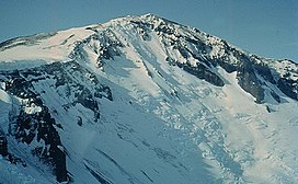
298:. A prominent bare rock scar of football shape on the north side of Football Mountain, on the ridge separating Edisto Inlet and Tucker Glacier. The scar is surrounded by an unbroken snow slope and is said to be always visible, though occasionally lightly covered by snow for short periods, and is consequently a landmark for pilots and men at Hallett station. Given this descriptive name by the NZGSAE, 1957-58.
239:. The Football, Football Mountain and Football Saddle are on the neck of land connecting the peninsula to the mainland. To the east, Mount Vernon Harcourt overlooks the south coast, which extends to Cape Wheatstone. North of this cape, Quarterdeck Ridge defines the eastern spine of the peninsula, and the Cotter Cliffs are its east face. Heave-ho Slope lies between Mount Vernon Harcourt and Quarterdeck Ridge.
612:. A slope falling 450 metres (1,480 ft) from Quarterdeck Ridge to a saddle at the southwestend of Hallett Peninsula. The slope must be traversed by parties moving overland from Hallett station to Tucker Glacier, after the bay ice in Edisto Inlet has broken out. The NZGSAE, 1957-58, met deep soft new snow in this area and sledges had to be man-hauled up the slope in relays, hence the name.
383:
844:. Glacier flowing from the west side of Hallett Peninsula 1 nautical mile (1.9 km; 1.2 mi) south of Seabee Hook and forming a short, floating ice tongue on the shore of Edisto Inlet. Named by the NZGSAE, 1957-58, for Lieutenant Robert C. Bornmann, MC, United States Navy, surgeon and leader of the United States Navy Operation Deep Freeze party at Hallett station in 1958.
768:. Steep glacier falling away from the west side of Hallett Peninsula and forming a floating ice tongue on the east shore of Edisto Inlet between Salmon and Roberts Cliffs. Named by the NZGSAE, 1957-58, for Lieutenant Albert H. Bridgman, MC, United States Navy, surgeon and United States Navy Operation Deep Freeze leader at Hallett station in 1959.
1310:
1254:
40:
892:. Named by the US-ACAN for the Seabee unit aboard the Edisto which investigated and surveyed this area for possible use as a base site for International Geophysical Year operations. Seabee is a phonetic spelling for "construction battalion" and now refers to individual or collective members of naval construction engineer units.
336:. Mountain, 830 metres (2,720 ft) high, with a prominent and peculiar rock scar called The Football on its north side, on the ridge between Edisto Inlet and Tucker Glacier. It was occupied as a survey station, and marked by a large rock caim, by the NZGSAE, 1957-58, who named it for The Football.
930:. Point marking the west side of the entrance to Willett Cove and the south end of Seabee Hook, a low recurved spit 1.5 nautical miles (2.8 km; 1.7 mi) west-southwest of Cape Hallett. Surveyed in January 1956 by members of United States Navy Operation Deep Freeze I aboard the icebreaker USS
688:. Glacier 3 nautical miles (5.6 km; 3.5 mi) long and 2 nautical miles (3.7 km; 2.3 mi) wide, situated in a cliff-walled bay between Hallett Peninsula and Redcastle Ridge and flowing northwest into Edisto Inlet as a floating ice tongue. Named by the NZGSAE, 1957-58, for the USS
888:. Low, recurved spit composed of coarse volcanic ash which projects about 0.5 nautical miles (0.93 km; 0.58 mi) west from the high rocky ridge forming Cape Hallett. Surveyed in January 1956 by members of United States Navy Operation Deep Freeze I aboard the icebreaker USS
175:) is a triangular, dome-shaped peninsula, 20 nautical miles (37 km; 23 mi) long, with 1,500 metres (4,900 ft) cliffs on its eastern seaboard side and 300 metres (980 ft) on its west side. The peninsula extends from
1314:
1258:
730:. The third prominent rock bluff south of Seabee Hook on the east shore of Edisto Inlet. Named by the NZGSAE, 1957-58, for Charles L. Roberts, Jr., USARP meteorologist and scientific leader at Hallett Station in 1959.
650:. A castlelike ridge of red and black volcanic rocks between Arneb Glacier and the terminal face of Edisto Glacier at the head of Edisto Inlet. So named by the NZGSAE, 1957-58, because of its coloring and shape.
247:. Arneb Glacier enter Edisto Inlet to the east of Redcastle Ridge. North of this are Roberts Cliff, Bridgman Glacier, Salmon Cliff, Bornmann Glacier, Seabee Hook and Cape Hallett, the northernmost point.
806:. The second prominent rock cliff south of Seabee Hook on the west side of Hallett Peninsula. Named by the NZGSAE, 1957-58, for K.J. Salmon, physicist and scientific leader at Hallett Station in 1958.
526:. The undulating, north-south snow crest of Hallett Peninsula. For the most part this crest is very close to the great 1,500 metres (4,900 ft) high Cotter Cliffs that fall abruptly to the
978:. A bold rock cape forming the north tip of Hallett Peninsula. Discovered in 1841 by Sir James Clark Ross who named it for Thomas R. Hallett, purser on one of the expedition ships, the
484:. A bold rock cape that forms the south end of Hallett Peninsula and marks the north entrance to Tucker Inlet. Discovered in January 1841 by Sir James Clark Ross who named it for Sir
188:
426:. A remarkable conical mountain 1,570 metres (5,150 ft) high, in the south-central part of Hallett Peninsula. Discovered in January 1841 by Sir
692:, which in the 1957 season carried the buildings and stores for the establishment of Hallett station and revisited the station in subsequent seasons.
105:
1353:
1262:
62:
1298:
1333:
1343:
431:
530:. So named by NZGSAE, 1957-58, because impressions obtained in traversing along it recall those in walking the quarterdeck of a ship.
1348:
1318:
1032:
55:
1338:
435:
950:
902:
860:
816:
778:
740:
702:
660:
622:
584:
546:
498:
456:
398:
346:
308:
270:
147:
220:
391:
1290:
446:
236:
485:
120:
255:
1294:
216:
427:
1025:
212:
192:
17:
1269:
240:
208:
180:
1327:
539:
124:
1236:
943:
244:
184:
176:
853:
196:
382:
128:
1026:"K/Ar and Rb/Sr dating of McMurdo Volcanic Group (north of Campbell Glacier)"
965:
952:
934:. So named by the US-ACAN because of its close association with Seabee Hook.
917:
904:
875:
862:
831:
818:
793:
780:
755:
742:
717:
704:
675:
662:
637:
624:
599:
586:
561:
548:
513:
500:
471:
458:
413:
400:
361:
348:
323:
310:
285:
272:
227:
lava of the
Hallett Peninsula has been dated to 6.4 ± 0.4 million years old.
162:
149:
77:
64:
39:
179:
to Cape
Wheatstone and is joined to the mainland by a narrow ridge between
527:
259:
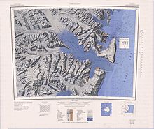
1:250,000 scale topographic map of
Hallett Peninsula and Tucker Glacier
224:
243:
runs past the southwest of the peninsula past
Redcastle Ridge into
445:
381:
254:
219:
peninsulas. It forms part of the
Hallett Volcanic Province of the
1058:
1056:
1054:
996:
994:
1244:(2 ed.), United States Board on Geographic Names
199:was established at the north end of the peninsula.
93:
54:
49:
32:
189:New Zealand Geological Survey Antarctic Expedition
235:The Hallett Peminsula lies to the east of the
1274:, USGS: United States Geological Survey, 1968
8:
1045:
1012:
29:
112:
1263:United States Board on Geographic Names
1218:
1206:
1194:
1182:
1170:
1158:
1146:
1134:
1122:
1110:
1098:
1086:
1074:
1062:
1000:
990:
7:
1317:from websites or documents of the
1261:from websites or documents of the
488:, English physicist and inventor.
25:
1238:Geographic Names of the Antarctic
1313: This article incorporates
1308:
1257: This article incorporates
1252:
111:
104:
38:
1319:United States Geological Survey
1354:Shield volcanoes of Antarctica
1235:Alberts, Fred G., ed. (1995),
430:and named by him for the Rev.
207:The peninsula is an elongated
1:
1287:Encyclopedia of the Antarctic
1033:Geological Society of America
434:, one of the founders of the
1334:Peninsulas of Victoria Land
191:(NZGSAE), 1957–58, because
1370:
1344:Volcanoes of Victoria Land
1285:Riffenburgh, Beau (2007),
941:
851:
537:
389:
187:. It was so named by the
98:
37:
18:The Football (Antarctica)
1349:Miocene shield volcanoes
432:William Vernon Harcourt
211:complex similar to the
27:Peninsula in Antarctica
1315:public domain material
1259:public domain material
451:
387:
260:
221:McMurdo Volcanic Group
449:
392:Mount Vernon Harcourt
385:
378:Mount Vernon Harcourt
258:
44:Mount Vernon Harcourt
1291:Taylor & Francis
962: /
914: /
872: /
828: /
790: /
752: /
714: /
672: /
634: /
596: /
558: /
510: /
468: /
436:British Association
410: /
358: /
320: /
282: /
237:Admiralty Mountains
159: /
74: /
1339:Borchgrevink Coast
966:72.317°S 170.267°E
918:72.317°S 170.217°E
896:Construction Point
876:72.317°S 170.217°E
832:72.333°S 170.217°E
794:72.367°S 170.100°E
756:72.383°S 170.083°E
718:72.400°S 170.083°E
676:72.417°S 170.033°E
638:72.433°S 169.950°E
600:72.533°S 170.167°E
562:72.467°S 170.300°E
514:72.450°S 170.267°E
486:Charles Wheatstone
472:72.617°S 170.217°E
452:
450:Charles Wheatstone
414:72.533°S 169.917°E
388:
362:72.517°S 169.767°E
324:72.517°S 169.700°E
286:72.500°S 169.700°E
261:
163:72.500°S 170.167°E
121:Borchgrevink Coast
78:72.500°S 170.167°E
50:Highest point
1300:978-0-415-97024-2
492:Quarterdeck Ridge
302:Football Mountain
142:Hallett Peninsula
139:
138:
33:Hallett Peninsula
16:(Redirected from
1361:
1312:
1311:
1303:
1281:
1280:
1279:
1256:
1255:
1251:
1250:
1249:
1243:
1222:
1216:
1210:
1204:
1198:
1192:
1186:
1180:
1174:
1168:
1162:
1156:
1150:
1144:
1138:
1132:
1126:
1120:
1114:
1108:
1102:
1096:
1090:
1084:
1078:
1072:
1066:
1060:
1049:
1046:Cape Hallet USGS
1043:
1037:
1036:
1030:
1022:
1016:
1013:Riffenburgh 2007
1010:
1004:
998:
977:
976:
974:
973:
972:
971:-72.317; 170.267
967:
963:
960:
959:
958:
955:
929:
928:
926:
925:
924:
923:-72.317; 170.217
919:
915:
912:
911:
910:
907:
887:
886:
884:
883:
882:
881:-72.317; 170.217
877:
873:
870:
869:
868:
865:
843:
842:
840:
839:
838:
837:-72.333; 170.217
833:
829:
826:
825:
824:
821:
810:Bornmann Glacier
805:
804:
802:
801:
800:
799:-72.367; 170.100
795:
791:
788:
787:
786:
783:
767:
766:
764:
763:
762:
761:-72.383; 170.083
757:
753:
750:
749:
748:
745:
734:Bridgman Glacier
729:
728:
726:
725:
724:
723:-72.400; 170.083
719:
715:
712:
711:
710:
707:
687:
686:
684:
683:
682:
681:-72.417; 170.033
677:
673:
670:
669:
668:
665:
649:
648:
646:
645:
644:
643:-72.433; 169.950
639:
635:
632:
631:
630:
627:
611:
610:
608:
607:
606:
605:-72.533; 170.167
601:
597:
594:
593:
592:
589:
573:
572:
570:
569:
568:
567:-72.467; 170.300
563:
559:
556:
555:
554:
551:
525:
524:
522:
521:
520:
519:-72.450; 170.267
515:
511:
508:
507:
506:
503:
483:
482:
480:
479:
478:
477:-72.617; 170.217
473:
469:
466:
465:
464:
461:
428:James Clark Ross
425:
424:
422:
421:
420:
419:-72.533; 169.917
415:
411:
408:
407:
406:
403:
386:James Clark Ross
373:
372:
370:
369:
368:
367:-72.517; 169.767
363:
359:
356:
355:
354:
351:
335:
334:
332:
331:
330:
329:-72.517; 169.700
325:
321:
318:
317:
316:
313:
297:
296:
294:
293:
292:
291:-72.500; 169.700
287:
283:
280:
279:
278:
275:
174:
173:
171:
170:
169:
168:-72.500; 170.167
164:
160:
157:
156:
155:
152:
115:
114:
108:
89:
88:
86:
85:
84:
83:-72.500; 170.167
79:
75:
72:
71:
70:
67:
42:
30:
21:
1369:
1368:
1364:
1363:
1362:
1360:
1359:
1358:
1324:
1323:
1309:
1306:
1301:
1293:, p. 639,
1289:, vol. 1,
1284:
1277:
1275:
1268:
1253:
1247:
1245:
1241:
1234:
1230:
1225:
1217:
1213:
1205:
1201:
1193:
1189:
1181:
1177:
1169:
1165:
1157:
1153:
1145:
1141:
1133:
1129:
1121:
1117:
1109:
1105:
1097:
1093:
1085:
1081:
1073:
1069:
1061:
1052:
1044:
1040:
1028:
1024:
1023:
1019:
1011:
1007:
999:
992:
988:
970:
968:
964:
961:
956:
953:
951:
949:
948:
946:
940:
922:
920:
916:
913:
908:
905:
903:
901:
900:
898:
880:
878:
874:
871:
866:
863:
861:
859:
858:
856:
850:
836:
834:
830:
827:
822:
819:
817:
815:
814:
812:
798:
796:
792:
789:
784:
781:
779:
777:
776:
774:
760:
758:
754:
751:
746:
743:
741:
739:
738:
736:
722:
720:
716:
713:
708:
705:
703:
701:
700:
698:
680:
678:
674:
671:
666:
663:
661:
659:
658:
656:
642:
640:
636:
633:
628:
625:
623:
621:
620:
618:
616:Redcastle Ridge
604:
602:
598:
595:
590:
587:
585:
583:
582:
580:
566:
564:
560:
557:
552:
549:
547:
545:
544:
542:
536:
518:
516:
512:
509:
504:
501:
499:
497:
496:
494:
476:
474:
470:
467:
462:
459:
457:
455:
454:
444:
442:Cape Wheatstone
418:
416:
412:
409:
404:
401:
399:
397:
396:
394:
380:
366:
364:
360:
357:
352:
349:
347:
345:
344:
342:
340:Football Saddle
328:
326:
322:
319:
314:
311:
309:
307:
306:
304:
290:
288:
284:
281:
276:
273:
271:
269:
268:
266:
253:
233:
205:
193:Hallett Station
167:
165:
161:
158:
153:
150:
148:
146:
145:
135:
134:
133:
132:
131:
118:
117:
116:
82:
80:
76:
73:
68:
65:
63:
61:
60:
45:
28:
23:
22:
15:
12:
11:
5:
1367:
1365:
1357:
1356:
1351:
1346:
1341:
1336:
1326:
1325:
1305:
1304:
1299:
1282:
1266:
1231:
1229:
1226:
1224:
1223:
1221:, p. 149.
1211:
1209:, p. 659.
1199:
1187:
1175:
1163:
1161:, p. 622.
1151:
1139:
1137:, p. 608.
1127:
1125:, p. 322.
1115:
1113:, p. 156.
1103:
1101:, p. 598.
1091:
1089:, p. 807.
1079:
1077:, p. 780.
1067:
1065:, p. 250.
1050:
1038:
1017:
1015:, p. 639.
1005:
1003:, p. 306.
989:
987:
984:
942:Main article:
939:
936:
897:
894:
852:Main article:
849:
846:
811:
808:
773:
770:
735:
732:
697:
694:
655:
652:
617:
614:
579:
578:Heave-ho Slope
576:
538:Main article:
535:
532:
493:
490:
443:
440:
390:Main article:
379:
376:
341:
338:
303:
300:
265:
262:
252:
249:
241:Edisto Glacier
232:
229:
209:shield volcano
204:
201:
181:Tucker Glacier
137:
136:
119:
110:
109:
103:
102:
101:
100:
99:
96:
95:
91:
90:
58:
52:
51:
47:
46:
43:
35:
34:
26:
24:
14:
13:
10:
9:
6:
4:
3:
2:
1366:
1355:
1352:
1350:
1347:
1345:
1342:
1340:
1337:
1335:
1332:
1331:
1329:
1322:
1320:
1316:
1302:
1296:
1292:
1288:
1283:
1273:
1272:
1267:
1264:
1260:
1240:
1239:
1233:
1232:
1227:
1220:
1215:
1212:
1208:
1203:
1200:
1197:, p. 82.
1196:
1191:
1188:
1184:
1179:
1176:
1173:, p. 93.
1172:
1167:
1164:
1160:
1155:
1152:
1149:, p. 28.
1148:
1143:
1140:
1136:
1131:
1128:
1124:
1119:
1116:
1112:
1107:
1104:
1100:
1095:
1092:
1088:
1083:
1080:
1076:
1071:
1068:
1064:
1059:
1057:
1055:
1051:
1047:
1042:
1039:
1034:
1027:
1021:
1018:
1014:
1009:
1006:
1002:
997:
995:
991:
985:
983:
981:
975:
945:
937:
935:
933:
927:
895:
893:
891:
885:
855:
847:
845:
841:
809:
807:
803:
771:
769:
765:
733:
731:
727:
696:Roberts Cliff
695:
693:
691:
685:
654:Arneb Glacier
653:
651:
647:
615:
613:
609:
577:
575:
571:
541:
540:Cotter Cliffs
534:Cotter Cliffs
533:
531:
529:
523:
491:
489:
487:
481:
448:
441:
439:
437:
433:
429:
423:
393:
384:
377:
375:
371:
339:
337:
333:
301:
299:
295:
263:
257:
250:
248:
246:
242:
238:
230:
228:
226:
222:
218:
214:
210:
202:
200:
198:
194:
190:
186:
182:
178:
172:
143:
130:
126:
125:Victoria Land
122:
107:
97:
92:
87:
59:
57:
53:
48:
41:
36:
31:
19:
1307:
1286:
1276:, retrieved
1270:
1246:, retrieved
1237:
1219:Alberts 1995
1214:
1207:Alberts 1995
1202:
1195:Alberts 1995
1190:
1183:Alberts 1995
1178:
1171:Alberts 1995
1166:
1159:Alberts 1995
1154:
1147:Alberts 1995
1142:
1135:Alberts 1995
1130:
1123:Alberts 1995
1118:
1111:Alberts 1995
1106:
1099:Alberts 1995
1094:
1087:Alberts 1995
1082:
1075:Alberts 1995
1070:
1063:Alberts 1995
1041:
1035:. p. 1.
1020:
1008:
1001:Alberts 1995
979:
947:
944:Cape Hallett
938:Cape Hallett
931:
899:
889:
857:
813:
775:
772:Salmon Cliff
737:
699:
689:
657:
619:
581:
543:
495:
453:
395:
343:
305:
267:
264:The Football
245:Edisto Inlet
234:
206:
185:Edisto Inlet
177:Cape Hallett
141:
140:
1271:Cape Hallet
969: /
921: /
879: /
854:Seabee Hook
848:Seabee Hook
835: /
797: /
759: /
721: /
679: /
641: /
603: /
565: /
517: /
475: /
417: /
365: /
327: /
289: /
197:Seabee Hook
166: /
81: /
56:Coordinates
1328:Categories
1278:2024-01-23
1248:2024-01-21
986:References
129:Antarctica
231:Geography
94:Geography
957:170°16′E
909:170°13′E
867:170°13′E
823:170°13′E
785:170°06′E
747:170°05′E
709:170°05′E
667:170°02′E
629:169°57′E
591:170°10′E
553:170°18′E
528:Ross Sea
505:170°16′E
463:170°13′E
405:169°55′E
353:169°46′E
315:169°42′E
277:169°42′E
251:Features
225:Basaltic
154:170°10′E
69:170°10′E
1228:Sources
954:72°19′S
906:72°19′S
864:72°19′S
820:72°20′S
782:72°22′S
744:72°23′S
706:72°24′S
664:72°25′S
626:72°26′S
588:72°32′S
550:72°28′S
502:72°27′S
460:72°37′S
402:72°32′S
350:72°31′S
312:72°31′S
274:72°30′S
217:Daniell
203:Geology
151:72°30′S
66:72°30′S
1297:
980:Erebus
932:Edisto
890:Edisto
1242:(PDF)
1029:(PDF)
690:Arneb
213:Adare
1295:ISBN
215:and
183:and
195:on
1330::
1321:.
1053:^
1031:.
993:^
982:.
438:.
223:.
127:,
123:,
1265:.
1185:.
1048:.
144:(
20:)
Text is available under the Creative Commons Attribution-ShareAlike License. Additional terms may apply.