493:. The west point of the cuspate Ridley Beach, 1 nautical mile (1.9 km; 1.2 mi) southwest of Cape Adare, Adare Peninsula, in northeast Victoria Land. Named in 1984 by the NZ-APC after Alexander Von Tunzelman, one of four New Zealanders taken on at Stewart Island as crew members of Antarctic, the ship of the Norwegian expedition, 1894-95, led by Captain Leonard Kristensen and Henrik J. Bull. He was a member of the launch party under Captain Kristensen which made a landing in the vicinity of this point, January 24, 1895, the first recorded landing in Victoria Land.
451:. A cuspate beach feature forming a triangle about 1 nautical mile (1.9 km; 1.2 mi) long on each side, lying 1 nautical mile (1.9 km; 1.2 mi) south of Cape Adare, on the west side of Adare Peninsula in northern Victoria Land. This was the camp site of the British Antarctic Expedition, 1898-1900, under C.E. Borchgrevink. He gave the camp his mother's maiden name. The Northern Party, led by Campbell, of the British Antarctic Expedition, 1910-13, disembarked here in 1911, and they gave the name to the entire beach. The beach is the site of an
104:
97:
663:. A line of precipitous basalt cliffs rising to 2,000 metres (6,600 ft) above the Ross Sea and forming much of the east side of Adare Peninsula. In 1841 Captain James Ross applied the name "Cape Downshire" to a part of these cliffs. He did so at the request of Cdr. Francis R.M. Crozier of the Terror, after the latter's friend, the late Marquis Downshire. No prominent cape exists here and, for the sake of historical continuity, the name has been reapplied to these cliffs.
701:. A small peak, 1,255 metres (4,117 ft) high, 4 nautical miles (7.4 km; 4.6 mi) south of Cape Adare in the north part of Adare Peninsula. Named by the NZ-APC after Nikolai Hanson, member of the British Antarctic Expedition, 1898-1900, under C.E. Borchgrevink, who was the first man known to have died on the Antarctic mainland (at Cape Adare, Oct. 14, 1899). Hanson's grave surmounts nearby Cape Adare.
31:
375:. The northern of two rocks called The Sisters, off the north extremity of Cape Adare. The Sisters were named by the British Antarctic Expedition, 1898-1900. Gertrude Rock was named by Campbell, leader of the Northern Party of the British Antarctic Expedition, 1910-13, at the suggestion of Levick, after Gertrude and Rose, two sisters mentioned in a favorite comic song of the time.
289:. A prominent cape of black basalt which is in visual contrast to the rest of the snow-covered coast, forming the north tip of Adare Peninsula. The cape marks the northeast extremity of Victoria Land and the west side of the entrance to the Ross Sea. Discovered in Jan. 1841 by Captain James Ross, Royal Navy, who named it for his friend Viscount Adare, M.P. for Glamorganshire.
413:. The southern of two rocks called The Sisters, off the north extremity of Cape Adare. The Sisters were named by the British Antarctic Expedition, 1898-1900. Rose Rock was named by Campbell, leader of the Northern Party of the British Antarctic Expedition, 1910-13, at the suggestion of Levick, after a favorite comic song which concerned two sisters named Rose and Gertrude.
243:
872:. A steep rock cape at the south tip of Adare Peninsula, marking the north side of the entrance to Moubray Bay along the east coast of Victoria Land. Discovered by Captain James Ross, 1841, who named it for Peter Mark Roget, noted English lexicographer who was Secretary of the Royal Society. The cape is the site of an Emperor penguin rookery.
1224:
1147:
781:
on the east side of Adare
Peninsula. The ice piedmont is formed by numerous glaciers draining the east side of Adare Peninsula between Downshire Cliffs and Cape McCormick. Named by New Zealand Geographic Board (NZGB) (2005) to honor the voluntary work and service given by
569:. A steep rock point 3.5 nautical miles (6.5 km; 4.0 mi) south of Ridley Beach on the west side of Adare Peninsula, northern Victoria Land. Charted and named in 1911 by the Northern Party, led by Campbell, of the British Antarctic Expedition, 1910-13.
739:. A rock lying in the sea just east of the north portion of Adare Peninsula, along the coast of Victoria Land. The descriptive name applied by NZ-APC suggests the location of this relatively small feature beside towering Downshire Cliffs.
531:. A rock lying along the west side of Adare Peninsula, immediately south of Ridley Beach, in northern Victoria Land. Charted and named in 1911 by the Northern Party led by Campbell of the British Antarctic Expedition, 1910-13.
607:. A saddle at about 900 metres (3,000 ft) high, situated at the junction of Adare Peninsula and the Admiralty Mountains, and at the junction of Newnes Glacier and Moubray Glacier which fall steeply from it. Named by the
1228:
1151:
327:. Two stacks or pillar-like rocks standing together just north of Cape Adare at the northeast extremity of Victoria Land. First charted and named The Sisters by the British Antarctic Expedition, 1898-1900, under
217:
6 to 13 million years old. Potassium–argon dates of 2.27 million years and perhaps 1.14 million years have also been obtained. The Adare
Peninsula shields form part of the Hallett Volcanic Province of the
608:
824:. Cape marking the east extremity of Adare Peninsula in Victoria Land. Discovered by Captain James Ross, 1841, who named it for Robert McCormick, Surgeon on the
190:
331:. The northern pillar was later named Gertrude Rock, and the southern one Rose Rock, by the Northern Party of British Antarctic Expedition, 1910-13.
1192:
96:
1282:
1155:
1277:
1267:
1212:
1247:
1262:
1183:
1178:
1272:
53:
1232:
1188:
46:
1252:
844:
796:
749:
711:
673:
635:
579:
541:
503:
465:
423:
385:
347:
299:
261:
157:
1109:
786:
over more than a decade to furthering the protection of historic sites under New
Zealand’s care in Antarctica.
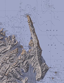
185:), is a high ice-covered peninsula, 40 nautical miles (74 km; 46 mi) long, in the northeast part of
1114:
1257:
219:
137:
328:
198:
1204:
783:
194:
1208:
452:
246:
628:
214:
619:
Named features on the east coast, which faces the Ross Sea, are (from north to south):
210:
142:
1162:
1241:
340:
231:
186:
116:
1129:
778:
193:(NZ-APC) for Cape Adare. The peninsula is considered the southernmost point of the
30:
189:, extending south from Cape Adare to Cape Roget. The peninsula was named by the
1104:
837:
254:
120:
859:
846:
811:
798:
764:
751:
726:
713:
688:
675:
650:
637:
594:
581:
556:
543:
518:
505:
480:
467:
438:
425:
400:
387:
362:
349:
314:
301:
276:
263:
172:
159:
68:
55:
611:(NZGSAE), 1957-58, in association with Adare Peninsula and Cape Adare.
242:
241:
927:
925:
904:
888:
886:
884:
1137:(2 ed.), United States Board on Geographic Names
1063:
136:
131:
84:
45:
40:
23:
609:New Zealand Geological Survey Antarctic Expedition
230:Named features on the west coast, which faces
1167:, USGS: United States Geological Survey, 1968
8:
209:The Adare Peninsula consists of overlapping
931:
916:
191:New Zealand Antarctic Place-Names Committee
20:
1193:United States Department of the Interior
1156:United States Board on Geographic Names
1087:
1075:
1051:
1039:
1027:
1015:
1003:
991:
979:
967:
955:
943:
892:
880:
103:
16:Mountain in Ross Dependency, Antarctica
7:
1184:Geographic Names Information System
1231:from websites or documents of the
1154:from websites or documents of the
14:
1131:Geographic Names of the Antarctic
1227: This article incorporates
1222:
1150: This article incorporates
1145:
102:
95:
29:
1233:United States Geological Survey
1189:United States Geological Survey
1283:Shield volcanoes of Antarctica
1128:Alberts, Fred G., ed. (1995),
1:
1201:Encyclopedia of the Antarctic
234:, are (from north to south):
1278:Pleistocene shield volcanoes
1268:Polygenetic shield volcanoes
1248:Peninsulas of Victoria Land
905:Adare Peninsula Smithsonian
1299:
1263:Volcanoes of Victoria Land
1199:Riffenburgh, Beau (2007),
835:
626:
338:
252:
1064:Fenwick Ice Piedmont USGS
89:
28:
1273:Miocene shield volcanoes
1110:Global Volcanism Program
1115:Smithsonian Institution
1229:public domain material
1179:"Fenwick Ice Piedmont"
1152:public domain material
250:
220:McMurdo Volcanic Group
245:
215:potassium–argon dated
1205:Taylor & Francis
743:Fenwick Ice Piedmont
329:Carsten Borchgrevink
199:Carsten Borchgrevink
1090:, pp. 626–627.
946:, pp. 678–679.
856: /
808: /
761: /
723: /
685: /
647: /
615:East coast features
591: /
553: /
515: /
477: /
459:Von Tunzelman Point
435: /
397: /
359: /
311: /
273: /
226:West coast features
169: /
65: /
1253:Borchgrevink Coast
860:71.983°S 170.617°E
812:71.833°S 170.967°E
727:71.383°S 170.400°E
689:71.350°S 170.300°E
651:71.617°S 170.600°E
595:71.733°S 170.200°E
557:71.367°S 170.233°E
519:71.317°S 170.217°E
481:71.300°S 170.183°E
439:71.300°S 170.217°E
401:71.283°S 170.217°E
363:71.283°S 170.217°E
315:71.283°S 170.217°E
277:71.283°S 170.233°E
251:
195:Borchgrevink Coast
173:71.667°S 170.500°E
69:71.667°S 170.500°E
41:Highest point
1214:978-0-415-97024-2
1105:"Adare Peninsula"
148:
147:
1290:
1226:
1225:
1217:
1195:
1174:
1173:
1172:
1149:
1148:
1144:
1143:
1142:
1136:
1124:
1123:
1121:
1091:
1085:
1079:
1073:
1067:
1061:
1055:
1049:
1043:
1037:
1031:
1025:
1019:
1013:
1007:
1001:
995:
989:
983:
977:
971:
965:
959:
953:
947:
941:
935:
929:
920:
917:Riffenburgh 2007
914:
908:
902:
896:
890:
871:
870:
868:
867:
866:
865:-71.983; 170.617
861:
857:
854:
853:
852:
849:
823:
822:
820:
819:
818:
817:-71.833; 170.967
813:
809:
806:
805:
804:
801:
776:
775:
773:
772:
771:
766:
765:71.75°S 170.75°E
762:
759:
758:
757:
754:
738:
737:
735:
734:
733:
732:-71.383; 170.400
728:
724:
721:
720:
719:
716:
700:
699:
697:
696:
695:
694:-71.350; 170.300
690:
686:
683:
682:
681:
678:
662:
661:
659:
658:
657:
656:-71.617; 170.600
652:
648:
645:
644:
643:
640:
629:Downshire Cliffs
623:Downshire Cliffs
606:
605:
603:
602:
601:
600:-71.733; 170.200
596:
592:
589:
588:
587:
584:
568:
567:
565:
564:
563:
562:-71.367; 170.233
558:
554:
551:
550:
549:
546:
530:
529:
527:
526:
525:
524:-71.317; 170.217
520:
516:
513:
512:
511:
508:
492:
491:
489:
488:
487:
486:-71.300; 170.183
482:
478:
475:
474:
473:
470:
450:
449:
447:
446:
445:
444:-71.300; 170.217
440:
436:
433:
432:
431:
428:
412:
411:
409:
408:
407:
406:-71.283; 170.217
402:
398:
395:
394:
393:
390:
374:
373:
371:
370:
369:
368:-71.283; 170.217
364:
360:
357:
356:
355:
352:
326:
325:
323:
322:
321:
320:-71.283; 170.217
316:
312:
309:
308:
307:
304:
288:
287:
285:
284:
283:
282:-71.283; 170.233
278:
274:
271:
270:
269:
266:
211:shield volcanoes
184:
183:
181:
180:
179:
178:-71.667; 170.500
174:
170:
167:
166:
165:
162:
143:Shield volcanoes
106:
105:
99:
80:
79:
77:
76:
75:
74:-71.667; 170.500
70:
66:
63:
62:
61:
58:
33:
21:
1298:
1297:
1293:
1292:
1291:
1289:
1288:
1287:
1238:
1237:
1223:
1220:
1215:
1203:, vol. 1,
1198:
1177:
1170:
1168:
1161:
1146:
1140:
1138:
1134:
1127:
1119:
1117:
1103:
1099:
1094:
1086:
1082:
1074:
1070:
1062:
1058:
1050:
1046:
1038:
1034:
1026:
1022:
1014:
1010:
1002:
998:
990:
986:
978:
974:
966:
962:
954:
950:
942:
938:
932:Cape Adare USGS
930:
923:
915:
911:
903:
899:
891:
882:
878:
864:
862:
858:
855:
850:
847:
845:
843:
842:
840:
834:
816:
814:
810:
807:
802:
799:
797:
795:
794:
792:
769:
767:
763:
760:
755:
752:
750:
748:
747:
745:
731:
729:
725:
722:
717:
714:
712:
710:
709:
707:
693:
691:
687:
684:
679:
676:
674:
672:
671:
669:
655:
653:
649:
646:
641:
638:
636:
634:
633:
631:
625:
617:
599:
597:
593:
590:
585:
582:
580:
578:
577:
575:
561:
559:
555:
552:
547:
544:
542:
540:
539:
537:
523:
521:
517:
514:
509:
506:
504:
502:
501:
499:
485:
483:
479:
476:
471:
468:
466:
464:
463:
461:
443:
441:
437:
434:
429:
426:
424:
422:
421:
419:
405:
403:
399:
396:
391:
388:
386:
384:
383:
381:
367:
365:
361:
358:
353:
350:
348:
346:
345:
343:
337:
319:
317:
313:
310:
305:
302:
300:
298:
297:
295:
281:
279:
275:
272:
267:
264:
262:
260:
259:
257:
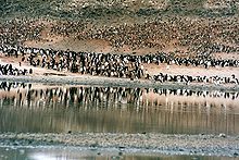
247:Adélie penguins
240:
228:
213:that have been
207:
177:
175:
171:
168:
163:
160:
158:
156:
155:
152:Adare Peninsula
127:
126:
125:
124:
123:
114:
113:
112:
111:
110:Adare Peninsula
107:
73:
71:
67:
64:
59:
56:
54:
52:
51:
36:
35:Adare Peninsula
24:Adare Peninsula
17:
12:
11:
5:
1296:
1294:
1286:
1285:
1280:
1275:
1270:
1265:
1260:
1255:
1250:
1240:
1239:
1219:
1218:
1213:
1196:
1175:
1159:
1125:
1100:
1098:
1095:
1093:
1092:
1080:
1078:, p. 474.
1068:
1056:
1054:, p. 522.
1044:
1042:, p. 311.
1032:
1030:, p. 198.
1020:
1018:, p. 660.
1008:
996:
994:, p. 787.
984:
982:, p. 618.
972:
970:, p. 631.
960:
958:, p. 275.
948:
936:
921:
919:, p. 639.
909:
897:
879:
877:
874:
836:Main article:
833:
830:
791:
790:Cape McCormick
788:
770:-71.75; 170.75
744:
741:
706:
703:
668:
665:
627:Main article:
624:
621:
616:
613:
574:
571:
536:
533:
498:
495:
460:
457:
453:Adélie penguin
418:
415:
380:
377:
339:Main article:
336:
333:
294:
291:
253:Main article:
239:
236:
227:
224:
206:
203:
146:
145:
140:
134:
133:
129:
128:
115:
109:
108:
101:
100:
94:
93:
92:
91:
90:
87:
86:
82:
81:
49:
43:
42:
38:
37:
34:
26:
25:
15:
13:
10:
9:
6:
4:
3:
2:
1295:
1284:
1281:
1279:
1276:
1274:
1271:
1269:
1266:
1264:
1261:
1259:
1258:Pennell Coast
1256:
1254:
1251:
1249:
1246:
1245:
1243:
1236:
1234:
1230:
1216:
1210:
1206:
1202:
1197:
1194:
1190:
1186:
1185:
1180:
1176:
1166:
1165:
1160:
1157:
1153:
1133:
1132:
1126:
1116:
1112:
1111:
1106:
1102:
1101:
1096:
1089:
1084:
1081:
1077:
1072:
1069:
1065:
1060:
1057:
1053:
1048:
1045:
1041:
1036:
1033:
1029:
1024:
1021:
1017:
1012:
1009:
1006:, p. 83.
1005:
1000:
997:
993:
988:
985:
981:
976:
973:
969:
964:
961:
957:
952:
949:
945:
940:
937:
933:
928:
926:
922:
918:
913:
910:
906:
901:
898:
894:
889:
887:
885:
881:
875:
873:
869:
839:
831:
829:
827:
821:
789:
787:
785:
780:
774:
742:
740:
736:
705:Nestling Rock
704:
702:
698:
666:
664:
660:
630:
622:
620:
614:
612:
610:
604:
572:
570:
566:
534:
532:
528:
496:
494:
490:
458:
456:
454:
448:
416:
414:
410:
378:
376:
372:
342:
341:Gertrude Rock
335:Gertrude Rock
334:
332:
330:
324:
292:
290:
286:
256:
249:at Cape Adare
248:
244:
237:
235:
233:
232:Robertson Bay
225:
223:
221:
216:
212:
204:
202:
201:(1864-1934).
200:
196:
192:
188:
187:Victoria Land
182:
153:
144:
141:
139:
138:Mountain type
135:
130:
122:
118:
117:Victoria Land
98:
88:
83:
78:
50:
48:
44:
39:
32:
27:
22:
19:
1221:
1200:
1182:
1169:, retrieved
1163:
1139:, retrieved
1130:
1120:14 September
1118:, retrieved
1108:
1088:Alberts 1995
1083:
1076:Alberts 1995
1071:
1059:
1052:Alberts 1995
1047:
1040:Alberts 1995
1035:
1028:Alberts 1995
1023:
1016:Alberts 1995
1011:
1004:Alberts 1995
999:
992:Alberts 1995
987:
980:Alberts 1995
975:
968:Alberts 1995
963:
956:Alberts 1995
951:
944:Alberts 1995
939:
912:
900:
895:, p. 4.
893:Alberts 1995
841:
825:
793:
779:ice piedmont
746:
708:
670:
632:
618:
576:
573:Adare Saddle
538:
500:
497:Boulder Rock
462:
420:
417:Ridley Beach
382:
344:
296:
258:
229:
208:
197:, named for
151:
149:
18:
863: /
815: /
784:Rob Fenwick
768: /
730: /
692: /
667:Hanson Peak
654: /
598: /
560: /
522: /
484: /
442: /
404: /
366: /
318: /
293:The Sisters
280: /
176: /
72: /
47:Coordinates
1242:Categories
1171:2024-01-23
1164:Cape Adare
1141:2024-01-21
876:References
838:Cape Roget
832:Cape Roget
535:Seal Point
255:Cape Adare
238:Cape Adare
121:Antarctica
455:rookery.
379:Rose Rock
85:Geography
851:170°37′E
803:170°58′E
756:170°45′E
718:170°24′E
680:170°18′E
642:170°36′E
586:170°12′E
548:170°14′E
510:170°13′E
472:170°11′E
430:170°13′E
392:170°13′E
354:170°13′E
306:170°13′E
268:170°14′E
164:170°30′E
60:170°30′E
1097:Sources
848:71°59′S
800:71°50′S
753:71°45′S
715:71°23′S
677:71°21′S
639:71°37′S
583:71°44′S
545:71°22′S
507:71°19′S
469:71°18′S
427:71°18′S
389:71°17′S
351:71°17′S
303:71°17′S
265:71°17′S
205:Geology
161:71°40′S
132:Geology
57:71°40′S
1211:
826:Erebus
777:. An
1135:(PDF)
1209:ISBN
1122:2016
150:The
1244::
1235:.
1207:,
1191:,
1187:,
1181:,
1113:,
1107:,
924:^
883:^
828:.
222:.
119:,
1158:.
1066:.
934:.
907:.
154:(
Text is available under the Creative Commons Attribution-ShareAlike License. Additional terms may apply.