31:
47:
436:
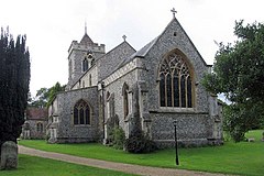
font were removed from the old church and built into the new structure. The tower contains six bells dating from 1597, 1608, 1626, 1656, 1689 with the most recent from 1707. For years these bells were not used and worship services were marked by the ringing of a bell dated 1862 that hung from a tree in a nearby field. The church register dates from the year 1538.
54:
457:
for the Church property. When in 1966 the
Congregational Union was replaced by a body which espoused more liberal views, the Chapel seceded and became affiliated first to the Fellowship of Independent Evangelical Churches (FIEC), and then to the Evangelical Fellowship of Congregational Churches (EFCC).
216:
435:
In
Therfield the Church of St Mary the Virgin has stood the test of time. The most recent building was completed in 1878 and it replaced the church that had existed since the 13th Century which fell into such disrepair that it was in danger of collapsing. When it was replaced, the windows, pulpit and
460:
In 1965, Allon Taffs was ordained as Pastor, after serving the church as
Secretary/informal leader for some 10 years before. He remained until May 1993. After a period of interregnum, during which time the church was cared for and led by the elders and deacons, the Rev Mark Kingston was appointed as
456:
Therfield Chapel was established as a congregation of
Protestant dissenters (the "Independents") in 1836. The current Chapel was built subsequently, in 1854, and the Church eventually became known as Therfield Congregational Church, being affiliated to the Congregational Union who acted as trustees
543:
before it was finished. It seems that it did or would have connected to a further embankment surrounding the original part of
Therfield. The Castle is owned by Tuthill Farm and it was excavated in 1958 by a team led by Martin Biddle when the owner informed the
565:
461:
Pastor in August 1997. He served the church until he resigned in July 2002. Andrew Carter was appointed as Pastor in
February 2006 until January 2016. In May 2016, Joshua Jones was appointed and currently serves as Pastor.
817:
256:
264:
120:
240:
810:
93:
388:
and means either 'Thunor's Field' or 'Thunor's High place", from the same
Germanic root that gives 'veldt'. The village was inhabited long before the
1657:
803:
826:
202:
412:
lies a mile to the north of the village. From here on a clear day it is possible to see the
Cathedral of Ely, over twenty miles to the north.
46:
233:
470:
228:
300:
1652:
601:
545:
507:
and district councils. Therfield Parish
Council came into being on 13 December 1894, taking over the secular functions of the parish
548:
that he intended to bulldoze the site. The farmer was dissuaded from damaging the motte but most of the baily was levelled in 1960.
245:
785:
282:
1631:
292:
190:
156:
30:
408:
Today
Therfield is known as a very small village that is locally famous for its church, chapel and pub. The Nature Reserve of
86:
474:
1436:
489:
221:
714:"'The rich man in his castle, the poor man at his gate': castle baileys and settlement patterns in Norman England"
1482:
1477:
1416:
1135:
904:
504:
500:
485:
337:
287:
1276:
990:
980:
924:
170:
469:
Therfield has three tiers of local government at parish, district and county level: Therfield Parish Council,
1569:
1564:
1291:
1216:
1030:
1010:
437:
1391:
1386:
1376:
1371:
1351:
1341:
1326:
1311:
1256:
1185:
1150:
1130:
1120:
970:
520:
516:
512:
493:
341:
1605:
1497:
1421:
1396:
1366:
1346:
1266:
950:
945:
985:
1235:
965:
739:
682:
539:
ruins of a motte and bailey castle. The fortification was most likely constructed in 1143-44 and was
102:
1579:
1406:
1381:
1245:
1165:
524:
445:
110:
1085:
934:
536:
515:
from 28 December 1894. Despite the name, Ashwell Rural District Council was based in the town of
138:
593:
587:
1125:
759:
597:
424:
416:
1554:
1331:
889:
751:
687:
352:
195:
1543:
1457:
1175:
1140:
1065:
879:
441:
420:
409:
146:
713:
683:"Motte and bailey castle and associated earthworks 100m south of Tuthill Farm, Therfield"
1508:
1487:
1115:
1060:
1040:
496:
1646:
1589:
1559:
1533:
1523:
1462:
1095:
1090:
884:
830:
356:
128:
67:
1447:
1356:
1050:
1045:
1000:
975:
864:
755:
656:
481:
393:
389:
795:
1574:
1518:
1401:
1296:
1231:
1105:
1015:
919:
909:
854:
1513:
1155:
1025:
1005:
899:
381:
763:
315:
302:
1610:
1472:
1452:
1426:
1336:
1316:
1306:
1200:
1070:
995:
869:
859:
540:
397:
180:
1467:
1321:
1286:
1281:
1221:
1211:
1180:
1170:
1055:
1020:
960:
894:
874:
740:"The Excavation of a Motte and Bailey Castle at Therfield, Hertfordshire"
618:
336:
is both a small village of approximately 4,761 acres (19 km) and a
1615:
1528:
1271:
1261:
1226:
1190:
1160:
1110:
1100:
1080:
1075:
1035:
955:
849:
838:
349:
345:
162:
1584:
1361:
1301:
508:
444:
royal arms survives, and is unusual in that the inscription on the
1145:
914:
519:. Ashwell Rural District was abolished in 1935, becoming part of
385:
799:
440:
was buried here in the chancel in 1700. The church's original
724:. Publications du CRAHM: 32 – via Open Research Exeter.
780:
642:
Parish and District Councils Election Results: Therfield,
340:
which sits upon the chalk range, three miles southwest of
790:
523:, which in turn was abolished in 1974, becoming part of
419:
passes through the village on its 110-mile journey from
589:
The Royal Arms - Its Graphic And Decorative Development
1624:
1598:
1542:
1496:
1435:
1244:
1199:
933:
837:
255:
239:
227:
215:
201:
189:
179:
169:
155:
137:
119:
101:
85:
77:
23:
744:Journal of the British Archaeological Association
663:. GB Historical GIS / University of Portsmouth
511:, and the parish of Therfield was included in
811:
8:
400:barrows have been found on Therfield Heath.
818:
804:
796:
344:, and six miles (10 km) northeast of
20:
657:"Therfield Civil Parish / Ancient Parish"
644:Herts and Cambs Reporter and Royston Crow
557:
254:
210:
178:
154:
84:
27:
372:The name Therfield is a variation of
238:
226:
214:
200:
188:
168:
136:
118:
100:
7:
733:
731:
707:
705:
471:North Hertfordshire District Council
781:History and pictures of Therfield.
14:
53:
661:A Vision of Britain through Time
492:. Therfield was included in the
52:
45:
29:
1658:Civil parishes in Hertfordshire
1632:List of places in Hertfordshire
756:10.1080/00681288.1964.11894838
566:"Civil Parish population 2011"
1:
786:Hagg*r One Name Study Project
431:Church of St. Mary the Virgin
475:Hertfordshire County Council
87:OS grid reference
18:Human settlement in England
1674:
1599:Wholly unparished boroughs
1653:Villages in Hertfordshire
905:Nettleden with Potten End
646:, 7 December 1894, page 8
501:Local Government Act 1894
484:, and it was part of the
273:
251:
211:
40:
28:
791:Hagger Genealogy Library
619:"Royston Poor Law Union"
586:Hasler, Charles (1980).
265:North East Hertfordshire
1217:Elstree and Borehamwood
738:Biddle, Martin (1964).
712:Creighton, O.H (2004).
535:Therfield contains the
438:Francis Turner (bishop)
384:placename referring to
1131:Stanstead St Margarets
521:Hitchin Rural District
513:Ashwell Rural District
423:in Buckinghamshire to
191:Postcode district
617:Higginbotham, Peter.
396:runs through it, and
448:is partly misspelt.
171:Sovereign state
1580:Northaw and Cuffley
1246:North Hertfordshire
592:. Jupiter. p.
525:North Hertfordshire
312: /
111:North Hertfordshire
1086:Little Berkhamsted
1006:Brickendon Liberty
986:Bishop's Stortford
935:East Hertfordshire
316:52.0163°N 0.0575°W
257:UK Parliament
203:Dialling code
35:St Mary, Therfield
1640:
1639:
1547:(partly parished)
1501:(partly parished)
1440:(partly parished)
1249:(partly parished)
1222:Hertsmere Meriden
1204:(partly parished)
938:(wholly parished)
842:(partly parished)
546:Ministry of Works
425:Knettishall Heath
417:Icknield Way Path
331:
330:
121:Shire county
1665:
1555:Ayot St Lawrence
1548:
1502:
1441:
1407:St Paul's Walden
1250:
1205:
1126:Stanstead Abbots
939:
890:Little Gaddesden
843:
820:
813:
806:
797:
768:
767:
735:
726:
725:
718:Château Gaillard
709:
700:
699:
697:
695:
688:Historic England
679:
673:
672:
670:
668:
653:
647:
640:
634:
633:
631:
629:
614:
608:
607:
583:
577:
576:
574:
572:
562:
480:Therfield is an
452:Therfield Chapel
327:
326:
324:
323:
322:
321:52.0163; -0.0575
317:
313:
310:
309:
308:
305:
279:
165:
97:
96:
66:Location within
56:
55:
49:
33:
21:
1673:
1672:
1668:
1667:
1666:
1664:
1663:
1662:
1643:
1642:
1641:
1636:
1620:
1594:
1546:
1544:Welwyn Hatfield
1538:
1500:
1492:
1458:Harpenden Rural
1439:
1431:
1248:
1240:
1203:
1195:
1176:Watton-at-Stone
1141:Stocking Pelham
1066:Hertingfordbury
937:
929:
880:Great Gaddesden
841:
833:
824:
777:
772:
771:
737:
736:
729:
711:
710:
703:
693:
691:
681:
680:
676:
666:
664:
655:
654:
650:
641:
637:
627:
625:
616:
615:
611:
604:
585:
584:
580:
570:
568:
564:
563:
559:
554:
533:
499:from 1835. The
467:
454:
433:
421:Ivinghoe Beacon
410:Therfield Heath
406:
370:
368:Ancient history
365:
348:and within the
320:
318:
314:
311:
306:
303:
301:
299:
298:
297:
277:
269:
246:East of England
161:
151:
133:
115:
92:
91:
81:556 (2011)
73:
72:
71:
70:
64:
63:
62:
61:
57:
36:
19:
12:
11:
5:
1671:
1669:
1661:
1660:
1655:
1645:
1644:
1638:
1637:
1635:
1634:
1628:
1626:
1622:
1621:
1619:
1618:
1613:
1608:
1602:
1600:
1596:
1595:
1593:
1592:
1587:
1582:
1577:
1572:
1567:
1562:
1557:
1551:
1549:
1540:
1539:
1537:
1536:
1531:
1526:
1521:
1516:
1511:
1509:Abbots Langley
1505:
1503:
1494:
1493:
1491:
1490:
1488:Wheathampstead
1485:
1480:
1475:
1470:
1465:
1460:
1455:
1453:Harpenden Town
1450:
1444:
1442:
1433:
1432:
1430:
1429:
1424:
1419:
1414:
1409:
1404:
1399:
1394:
1389:
1384:
1379:
1374:
1369:
1364:
1359:
1354:
1349:
1344:
1339:
1334:
1329:
1324:
1319:
1314:
1309:
1304:
1299:
1294:
1289:
1284:
1279:
1274:
1269:
1264:
1259:
1253:
1251:
1242:
1241:
1239:
1238:
1229:
1224:
1219:
1214:
1208:
1206:
1197:
1196:
1194:
1193:
1188:
1183:
1178:
1173:
1168:
1163:
1158:
1153:
1148:
1143:
1138:
1133:
1128:
1123:
1118:
1116:Sawbridgeworth
1113:
1108:
1103:
1098:
1093:
1088:
1083:
1078:
1073:
1068:
1063:
1061:Hertford Heath
1058:
1053:
1048:
1043:
1041:Furneux Pelham
1038:
1033:
1028:
1023:
1018:
1013:
1008:
1003:
998:
993:
988:
983:
978:
973:
968:
963:
958:
953:
948:
942:
940:
931:
930:
928:
927:
922:
917:
912:
907:
902:
897:
892:
887:
882:
877:
872:
867:
862:
857:
852:
846:
844:
835:
834:
827:Civil parishes
825:
823:
822:
815:
808:
800:
794:
793:
788:
783:
776:
775:External links
773:
770:
769:
727:
701:
674:
648:
635:
609:
603:978-0904041200
602:
578:
556:
555:
553:
550:
532:
529:
497:Poor Law Union
482:ancient parish
466:
463:
453:
450:
432:
429:
405:
402:
376:and anciently
369:
366:
364:
361:
329:
328:
296:
295:
290:
285:
280:
278:List of places
274:
271:
270:
268:
267:
261:
259:
253:
252:
249:
248:
243:
237:
236:
231:
225:
224:
219:
213:
212:
209:
208:
205:
199:
198:
193:
187:
186:
183:
177:
176:
175:United Kingdom
173:
167:
166:
159:
153:
152:
150:
149:
143:
141:
135:
134:
132:
131:
125:
123:
117:
116:
114:
113:
107:
105:
99:
98:
89:
83:
82:
79:
75:
74:
65:
59:
58:
51:
50:
44:
43:
42:
41:
38:
37:
34:
26:
25:
17:
13:
10:
9:
6:
4:
3:
2:
1670:
1659:
1656:
1654:
1651:
1650:
1648:
1633:
1630:
1629:
1627:
1623:
1617:
1614:
1612:
1609:
1607:
1604:
1603:
1601:
1597:
1591:
1590:Woolmer Green
1588:
1586:
1583:
1581:
1578:
1576:
1573:
1571:
1568:
1566:
1563:
1561:
1560:Ayot St Peter
1558:
1556:
1553:
1552:
1550:
1545:
1541:
1535:
1534:Watford Rural
1532:
1530:
1527:
1525:
1524:Croxley Green
1522:
1520:
1517:
1515:
1512:
1510:
1507:
1506:
1504:
1499:
1495:
1489:
1486:
1484:
1481:
1479:
1476:
1474:
1471:
1469:
1466:
1464:
1463:London Colney
1461:
1459:
1456:
1454:
1451:
1449:
1446:
1445:
1443:
1438:
1434:
1428:
1425:
1423:
1420:
1418:
1415:
1413:
1410:
1408:
1405:
1403:
1400:
1398:
1395:
1393:
1390:
1388:
1385:
1383:
1380:
1378:
1375:
1373:
1370:
1368:
1365:
1363:
1360:
1358:
1355:
1353:
1350:
1348:
1345:
1343:
1340:
1338:
1335:
1333:
1332:King's Walden
1330:
1328:
1325:
1323:
1320:
1318:
1315:
1313:
1310:
1308:
1305:
1303:
1300:
1298:
1295:
1293:
1290:
1288:
1285:
1283:
1280:
1278:
1275:
1273:
1270:
1268:
1265:
1263:
1260:
1258:
1255:
1254:
1252:
1247:
1243:
1237:
1233:
1230:
1228:
1225:
1223:
1220:
1218:
1215:
1213:
1210:
1209:
1207:
1202:
1198:
1192:
1189:
1187:
1184:
1182:
1179:
1177:
1174:
1172:
1169:
1167:
1164:
1162:
1159:
1157:
1154:
1152:
1149:
1147:
1144:
1142:
1139:
1137:
1134:
1132:
1129:
1127:
1124:
1122:
1119:
1117:
1114:
1112:
1109:
1107:
1104:
1102:
1099:
1097:
1096:Little Munden
1094:
1092:
1091:Little Hadham
1089:
1087:
1084:
1082:
1079:
1077:
1074:
1072:
1069:
1067:
1064:
1062:
1059:
1057:
1054:
1052:
1049:
1047:
1044:
1042:
1039:
1037:
1034:
1032:
1029:
1027:
1024:
1022:
1019:
1017:
1014:
1012:
1009:
1007:
1004:
1002:
999:
997:
994:
992:
989:
987:
984:
982:
979:
977:
974:
972:
969:
967:
964:
962:
959:
957:
954:
952:
949:
947:
944:
943:
941:
936:
932:
926:
923:
921:
918:
916:
913:
911:
908:
906:
903:
901:
898:
896:
893:
891:
888:
886:
885:Kings Langley
883:
881:
878:
876:
873:
871:
868:
866:
863:
861:
858:
856:
853:
851:
848:
847:
845:
840:
836:
832:
831:Hertfordshire
828:
821:
816:
814:
809:
807:
802:
801:
798:
792:
789:
787:
784:
782:
779:
778:
774:
765:
761:
757:
753:
749:
745:
741:
734:
732:
728:
723:
719:
715:
708:
706:
702:
690:
689:
684:
678:
675:
662:
658:
652:
649:
645:
639:
636:
624:
623:The Workhouse
620:
613:
610:
605:
599:
595:
591:
590:
582:
579:
567:
561:
558:
551:
549:
547:
542:
538:
530:
528:
526:
522:
518:
514:
510:
506:
502:
498:
495:
491:
487:
483:
478:
476:
472:
464:
462:
458:
451:
449:
447:
443:
439:
430:
428:
426:
422:
418:
413:
411:
403:
401:
399:
395:
391:
387:
383:
379:
375:
367:
363:Brief history
362:
360:
358:
357:Hertfordshire
354:
351:
347:
343:
339:
335:
325:
294:
293:Hertfordshire
291:
289:
286:
284:
281:
276:
275:
272:
266:
263:
262:
260:
258:
250:
247:
244:
242:
235:
234:Hertfordshire
232:
230:
223:
222:Hertfordshire
220:
218:
206:
204:
197:
194:
192:
184:
182:
174:
172:
164:
160:
158:
148:
145:
144:
142:
140:
130:
129:Hertfordshire
127:
126:
124:
122:
112:
109:
108:
106:
104:
95:
90:
88:
80:
76:
69:
68:Hertfordshire
48:
39:
32:
22:
16:
1498:Three Rivers
1448:Colney Heath
1411:
1357:Nuthampstead
1051:Great Munden
1046:Great Amwell
1001:Brent Pelham
976:Bengeo Rural
865:Chipperfield
750:(1): 53–91.
747:
743:
721:
717:
692:. Retrieved
686:
677:
665:. Retrieved
660:
651:
643:
638:
626:. Retrieved
622:
612:
588:
581:
571:28 September
569:. Retrieved
560:
534:
479:
468:
459:
455:
434:
427:in Suffolk.
414:
407:
394:Icknield Way
390:Anglo Saxons
377:
373:
371:
338:civil parish
333:
332:
15:
1575:North Mymms
1519:Chorleywood
1402:St Ippolyts
1297:Great Ashby
1232:South Mimms
1106:Much Hadham
1016:Buntingford
920:Tring Rural
910:Northchurch
855:Berkhamsted
694:28 December
667:11 December
628:11 December
319: /
1647:Categories
1606:Broxbourne
1514:Batchworth
1483:St Stephen
1478:St Michael
1417:Wallington
1156:Thundridge
1136:Stapleford
1026:Datchworth
900:Nash Mills
552:References
465:Governance
392:came: the
382:theophoric
380:. It is a
304:52°00′59″N
78:Population
1611:Stevenage
1473:Sandridge
1437:St Albans
1427:Wymondley
1412:Therfield
1337:Knebworth
1317:Ickleford
1307:Hinxworth
1277:Caldecote
1201:Hertsmere
1071:High Wych
996:Braughing
991:Bramfield
981:Benington
925:Wigginton
870:Flamstead
860:Bovingdon
764:0068-1288
537:scheduled
398:Neolithic
378:Þurreweld
374:Tharfield
334:Therfield
307:0°03′27″W
241:Ambulance
181:Post town
60:Therfield
24:Therfield
1625:See also
1570:Hatfield
1565:Essendon
1468:Redbourn
1322:Kelshall
1292:Graveley
1287:Codicote
1282:Clothall
1212:Aldenham
1181:Westmill
1171:Wareside
1056:Hertford
1031:Eastwick
1021:Cottered
1011:Buckland
961:Aspenden
895:Markyate
875:Flaunden
541:slighted
503:created
103:District
94:TL334371
1616:Watford
1529:Sarratt
1392:Rushden
1387:Royston
1377:Radwell
1372:Preston
1352:Newnham
1342:Langley
1327:Kimpton
1312:Holwell
1272:Bygrave
1262:Barkway
1257:Ashwell
1227:Shenley
1191:Wyddial
1186:Widford
1161:Walkern
1151:Thorley
1121:Standon
1111:Sacombe
1101:Meesden
1081:Hunsdon
1076:Hormead
1036:Gilston
971:Bayford
956:Ardeley
850:Aldbury
839:Dacorum
517:Royston
494:Royston
486:hundred
350:English
346:Baldock
342:Royston
288:England
185:ROYSTON
163:England
157:Country
1585:Welwyn
1422:Weston
1397:Sandon
1367:Pirton
1362:Offley
1347:Lilley
1302:Hexton
1267:Barley
951:Anstey
946:Albury
762:
600:
531:Castle
509:vestry
505:parish
473:, and
446:Garter
442:Stuart
386:Thunor
353:county
217:Police
139:Region
1236:Ridge
1146:Tewin
966:Aston
915:Tring
746:. 3.
490:Odsey
404:Today
207:01763
1382:Reed
1234:and
1166:Ware
760:ISSN
696:2021
669:2021
630:2021
598:ISBN
573:2015
415:The
229:Fire
147:East
829:in
752:doi
594:200
488:of
359:.
355:of
196:SG8
1649::
758:.
748:27
742:.
730:^
722:21
720:.
716:.
704:^
685:.
659:.
621:.
596:.
527:.
477:.
283:UK
819:e
812:t
805:v
766:.
754::
698:.
671:.
632:.
606:.
575:.
Text is available under the Creative Commons Attribution-ShareAlike License. Additional terms may apply.