54:
38:
61:
493:. The generating station was expanded in 1914 with the addition of Unit 4. Unit 5 was added in 1918 and Unit 6 in 1948. Railroad tracks built into the generator floor allowed for installation and maintenance of the equipment. The complex was later transferred to the Saint Louis Power Company. Today it is owned by Minnesota Power, a division of Allete, Inc.
496:
Heavy rains in June 2012 created an historic flood in the region which overtopped the dam, breached the forebay canal and severely damaged the hydroelectric station. Following $ 90 million in reconstruction and upgrades, including the addition of a new emergency spillway, the facility came back
497:
online in
November, 2014. Additional upgrades will continue through 2018, including removal of the original 46kV transmission line equipment in favor of other, higher voltage equipment that was added later.
1147:
1142:
513:. However, the Thomson Project is actually composed of multiple dams and control structures, several of which have been rebuilt and merged over the years. Today the
93:
53:
506:
427:
213:
1152:
865:
315:
514:
958:
1157:
928:
490:
168:
510:
1050:
1137:
517:
National
Inventory of Dams (NID) counts 18 structures as part of the complex, with 14 formally listed as separate.
442:. It consists of a 1600-foot (488 m) long primary structure and multiple supplementary dams which, together with
80:
1008:
450:
449:
The tallest dam in the complex is 51.6 feet (16 m) and the longest is 3500 feet (1067 m). A series of
466:
178:
454:
431:
367:
446:
rock outcrops known as the
Thomson formation, impound the river to create Thomson Reservoir.
1025:
128:
16:
This article is about
Thomson Dam in Minnesota. For the dam by the same name Australia, see
489:
Thomson Dam was completed in 1907 by Great
Northern Power, an operating division of the
851:
609:
587:
561:
419:
380:
347:
287:
195:
37:
1131:
478:
439:
357:
1105:
829:
805:
783:
719:
697:
675:
651:
565:
443:
423:
199:
17:
462:
505:
The most visible part of
Thomson Dam is the primary structure straddling the
330:
317:
108:
95:
435:
741:
470:
458:
373:
240:
203:
42:
Downstream face of the main
Thomson Dam on the St. Louis River in 2017
983:
894:
1079:
1106:"Minnesota Power invests in safety improvements to hydro system"
959:"Carlton County rebuilds smarter after devastating 2012 flood"
474:
386:
190:
398:
1148:
Buildings and structures in
Carlton County, Minnesota
379:
366:
356:
346:
309:
304:
296:
286:
278:
270:
265:
257:
249:
239:
229:
219:
209:
189:
184:
174:
164:
150:
142:
134:
124:
87:
76:
30:
1051:"Listing of Minnesota Hydropower Facility Sites"
60:
473:and an annual generation of approximately 280
957:Peterson, Jana; Lund, Jamie (June 22, 2017).
8:
988:Minnesota Power: Reservoirs and Recreation
519:
27:
1058:Minnesota Department of Natural Resources
889:
887:
885:
883:
881:
261:60,000 cu ft/s (1,700 m/s)
866:List of dams and reservoirs in Minnesota
521:Thomson Dam - NID Registered Structures
1143:Hydroelectric power plants in Minnesota
877:
820:(Nos. 11, 11-1/2 and Upper Gate House)
952:
950:
929:"CorpsMap: National Inventory of Dams"
292:9,154 sq mi (23,710 km)
1014:. Minnesota Power. September 1, 2015.
933:United States Army Corps of Engineers
923:
921:
919:
917:
915:
515:United States Army Corps of Engineers
477:, the Thomson project is the largest
282:4,352 acre⋅ft (5,368,000 m)
7:
1110:Minnesota Power is an ALLETE Company
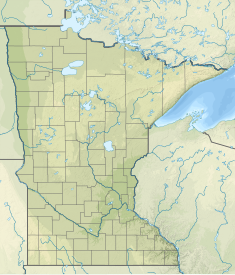
68:Location of Thomson Dam in Minnesota
469:. With an installed capacity of 72
235:Canal: 3,500 ft (1,100 m)
14:
1153:1907 establishments in Minnesota
233:Main: 1,600 ft (490 m)
59:
52:
36:
1009:"2015 Integrated Resource Plan"
1080:"Hometown Hydropower: History"
1:
584:3,500 ft (1,100 m)
225:Canal: 45 ft (14 m)
223:Main: 15 ft (4.6 m)
899:Minnesota Power: Our System
735:51.6 ft (15.7 m)
672:1,322 ft (403 m)
558:1,600 ft (490 m)
511:Minnesota State Highway 210
1174:
1026:"Thomson Dam, Thomson, MN"
666:(Nos 2-3/4, 3, 3A, 4, 4A)
331:46.6549750°N 92.33362000°W
15:
848:450 ft (140 m)
826:365 ft (111 m)
628:530 ft (160 m)
392:
109:46.6664167°N 92.4071667°W
81:Carlton County, Minnesota
47:
35:
845:12 ft (3.7 m)
823:17 ft (5.2 m)
799:11 ft (3.4 m)
780:100 ft (30 m)
777:11 ft (3.4 m)
760:100 ft (30 m)
757:12 ft (3.7 m)
738:125 ft (38 m)
716:115 ft (35 m)
713:23 ft (7.0 m)
694:100 ft (30 m)
691:23 ft (7.0 m)
648:130 ft (40 m)
625:23 ft (7.0 m)
603:10 ft (3.0 m)
555:15 ft (4.6 m)
465:located 3 miles away in
352:375 ft (114 m)
336:46.6549750; -92.33362000
895:"Thomson Hydro Station"
802:80 ft (24 m)
669:38 ft (12 m)
645:9 ft (2.7 m)
606:90 ft (27 m)
581:45 ft (14 m)
481:facility in the state.
368:Installed capacity
300:649 acres (263 ha)
143:Construction began
114:46.6664167; -92.4071667
1158:Dams completed in 1907
491:Great Northern Railway
381:Annual generation
258:Spillway capacity
169:Great Northern Railway
25:Dam in Minnesota, U.S.
416:Thomson Water Project
412:Thomson Hydro Station
191:Type of dam
622:Thomson Dam #2A, 2B
467:Jay Cooke State Park
424:concrete gravity dam
410:, also known as the
984:"Thomson Reservoir"
710:Thomson Dam #5-1/2
642:Thomson Dam #2-1/2
600:Thomson Dam #1-1/2
522:
399:http://mphydro.com/
327: /
288:Catchment area
279:Total capacity
105: /
1112:. January 20, 2017
578:Thomson Canal Dam
520:
457:, and underground
250:Spillway type
160:2014 reconstructed
1138:Dams in Minnesota
1030:John A. Weeks III
857:
856:
507:Saint Louis River
430:near the town of
428:Saint Louis River
405:
404:
297:Surface area
274:Thomson Reservoir
214:Saint Louis River
185:Dam and spillways
151:Opening date
1165:
1122:
1121:
1119:
1117:
1102:
1096:
1095:
1093:
1091:
1086:. April 23, 1979
1076:
1070:
1069:
1067:
1065:
1055:
1047:
1041:
1040:
1038:
1036:
1022:
1016:
1015:
1013:
1005:
999:
998:
996:
994:
980:
974:
973:
971:
969:
954:
945:
944:
942:
940:
925:
910:
909:
907:
905:
891:
842:Thomson Dam #12
830:Concrete gravity
806:Concrete gravity
796:Thomson Dam #10
784:Concrete gravity
720:Concrete gravity
698:Concrete gravity
676:Concrete gravity
652:Concrete gravity
566:concrete gravity
523:
463:hydropower plant
434:in northeastern
401:
342:
341:
339:
338:
337:
332:
328:
325:
324:
323:
320:
200:Concrete Gravity
196:Earth Embankment
156:1914-48 expanded
120:
119:
117:
116:
115:
110:
106:
103:
102:
101:
98:
63:
62:
56:
40:
28:
1173:
1172:
1168:
1167:
1166:
1164:
1163:
1162:
1128:
1127:
1126:
1125:
1115:
1113:
1104:
1103:
1099:
1089:
1087:
1084:Minnesota Power
1078:
1077:
1073:
1063:
1061:
1053:
1049:
1048:
1044:
1034:
1032:
1024:
1023:
1019:
1011:
1007:
1006:
1002:
992:
990:
982:
981:
977:
967:
965:
956:
955:
948:
938:
936:
927:
926:
913:
903:
901:
893:
892:
879:
874:
862:
819:
818:Thomson Dam #11
774:Thomson Dam #9
754:Thomson Dam #8
732:Thomson Dam #6
688:Thomson Dam #5
665:
503:
487:
397:
396:
335:
333:
329:
326:
321:
318:
316:
314:
313:
234:
224:
179:Minnesota Power
159:
157:
155:
113:
111:
107:
104:
99:
96:
94:
92:
91:
72:
71:
70:
69:
66:
65:
64:
43:
26:
21:
12:
11:
5:
1171:
1169:
1161:
1160:
1155:
1150:
1145:
1140:
1130:
1129:
1124:
1123:
1097:
1071:
1042:
1017:
1000:
975:
946:
935:. October 2016
911:
876:
875:
873:
870:
869:
868:
861:
858:
855:
854:
849:
846:
843:
840:
837:
833:
832:
827:
824:
821:
816:
813:
809:
808:
803:
800:
797:
794:
791:
787:
786:
781:
778:
775:
772:
769:
765:
764:
761:
758:
755:
752:
749:
745:
744:
739:
736:
733:
730:
727:
723:
722:
717:
714:
711:
708:
705:
701:
700:
695:
692:
689:
686:
683:
679:
678:
673:
670:
667:
664:Thomson Dam #3
662:
659:
655:
654:
649:
646:
643:
640:
637:
633:
632:
629:
626:
623:
620:
617:
613:
612:
607:
604:
601:
598:
595:
591:
590:
585:
582:
579:
576:
573:
569:
568:
559:
556:
553:
550:
547:
543:
542:
539:
536:
533:
530:
527:
502:
499:
486:
483:
403:
402:
390:
389:
383:
377:
376:
370:
364:
363:
360:
354:
353:
350:
348:Hydraulic head
344:
343:
311:
307:
306:
302:
301:
298:
294:
293:
290:
284:
283:
280:
276:
275:
272:
268:
267:
263:
262:
259:
255:
254:
251:
247:
246:
243:
237:
236:
231:
227:
226:
221:
217:
216:
211:
207:
206:
193:
187:
186:
182:
181:
176:
172:
171:
166:
162:
161:
152:
148:
147:
144:
140:
139:
136:
132:
131:
126:
122:
121:
89:
85:
84:
78:
74:
73:
67:
58:
57:
51:
50:
49:
48:
45:
44:
41:
33:
32:
24:
13:
10:
9:
6:
4:
3:
2:
1170:
1159:
1156:
1154:
1151:
1149:
1146:
1144:
1141:
1139:
1136:
1135:
1133:
1111:
1107:
1101:
1098:
1085:
1081:
1075:
1072:
1059:
1052:
1046:
1043:
1031:
1027:
1021:
1018:
1010:
1004:
1001:
989:
985:
979:
976:
964:
960:
953:
951:
947:
934:
930:
924:
922:
920:
918:
916:
912:
900:
896:
890:
888:
886:
884:
882:
878:
871:
867:
864:
863:
859:
853:
850:
847:
844:
841:
838:
835:
834:
831:
828:
825:
822:
817:
814:
811:
810:
807:
804:
801:
798:
795:
792:
789:
788:
785:
782:
779:
776:
773:
770:
767:
766:
762:
759:
756:
753:
750:
747:
746:
743:
742:Concrete arch
740:
737:
734:
731:
728:
725:
724:
721:
718:
715:
712:
709:
706:
703:
702:
699:
696:
693:
690:
687:
684:
681:
680:
677:
674:
671:
668:
663:
660:
657:
656:
653:
650:
647:
644:
641:
638:
635:
634:
630:
627:
624:
621:
618:
615:
614:
611:
608:
605:
602:
599:
596:
593:
592:
589:
586:
583:
580:
577:
574:
571:
570:
567:
563:
560:
557:
554:
551:
548:
545:
544:
540:
537:
534:
531:
528:
525:
524:
518:
516:
512:
509:channel near
508:
500:
498:
494:
492:
484:
482:
480:
479:hydroelectric
476:
472:
468:
464:
460:
456:
452:
447:
445:
441:
440:United States
437:
433:
429:
425:
421:
417:
413:
409:
400:
395:
391:
388:
384:
382:
378:
375:
371:
369:
365:
361:
359:
355:
351:
349:
345:
340:
322:92°20′1.032″W
319:46°39′17.91″N
312:
308:
305:Thomson Hydro
303:
299:
295:
291:
289:
285:
281:
277:
273:
269:
264:
260:
256:
252:
248:
244:
242:
238:
232:
228:
222:
218:
215:
212:
208:
205:
201:
197:
194:
192:
188:
183:
180:
177:
173:
170:
167:
163:
153:
149:
145:
141:
137:
133:
130:
127:
123:
118:
100:92°24′25.80″W
97:46°39′59.10″N
90:
86:
82:
79:
75:
55:
46:
39:
34:
29:
23:
19:
1114:. Retrieved
1109:
1100:
1088:. Retrieved
1083:
1074:
1062:. Retrieved
1057:
1045:
1033:. Retrieved
1029:
1020:
1003:
991:. Retrieved
987:
978:
966:. Retrieved
963:Pine Journal
962:
937:. Retrieved
932:
902:. Retrieved
898:
552:Thomson Dam
504:
495:
488:
448:
415:
411:
407:
406:
393:
158:2012 damaged
22:
453:, a canal,
451:gate houses
444:precambrian
408:Thomson Dam
334: /
310:Coordinates
138:Operational
112: /
88:Coordinates
31:Thomson Dam
18:Thomson Dam
1132:Categories
872:References
852:Embankment
610:Embankment
588:Embankment
562:Embankment
501:Structures
420:embankment
529:Other ID
461:supply a
459:penstocks
436:Minnesota
266:Reservoir
241:Spillways
1116:July 30,
1090:July 30,
1064:July 30,
1035:July 30,
993:July 30,
968:July 30,
939:July 29,
904:July 30,
860:See also
836:MN83031
812:MN83030
790:MN83029
768:MN83028
748:MN83027
726:MN83026
704:MN83025
682:MN83024
658:MN83023
636:MN83022
616:MN83021
594:MN83020
572:MN00604
546:MN00604
418:, is an
358:Turbines
210:Impounds
175:Owner(s)
165:Built by
77:Location
535:Height
526:Dam ID
485:History
455:forebay
432:Thomson
426:on the
394:Website
271:Creates
125:Purpose
1060:. 2017
538:Width
230:Length
220:Height
135:Status
83:, U.S.
1054:(PDF)
1012:(PDF)
839:S009
815:S008
793:S007
771:S006
751:S005
729:S004
707:S013
685:S003
661:S002
639:S012
619:S001
597:S011
575:S010
541:Type
532:Name
253:gated
129:Power
1118:2017
1092:2017
1066:2017
1037:2017
995:2017
970:2017
941:2017
906:2017
564:and
422:and
385:280
204:Arch
154:1907
146:1905
763:na
631:na
475:GWh
414:or
387:GWh
372:72
1134::
1108:.
1082:.
1056:.
1028:.
986:.
961:.
949:^
931:.
914:^
897:.
880:^
549:–
471:MW
438:,
374:MW
362:6
202:,
198:,
1120:.
1094:.
1068:.
1039:.
997:.
972:.
943:.
908:.
245:2
20:.
Text is available under the Creative Commons Attribution-ShareAlike License. Additional terms may apply.