33:
337:. There were 45 households, comprising 72 males and 63 females, giving a sex ratio of 1.14 males per female. The median age was 46.0 years (compared with 37.4 years nationally), with 27 people (20.5%) aged under 15 years, 15 (11.4%) aged 15 to 29, 69 (52.3%) aged 30 to 64, and 24 (18.2%) aged 65 or older.
346:
Of those at least 15 years old, 27 (25.7%) people had a bachelor's or higher degree, and 9 (8.6%) people had no formal qualifications. The median income was $ 29,200, compared with $ 31,800 nationally. 18 people (17.1%) earned over $ 70,000 compared to 17.2% nationally. The employment status of those
244:
The first
European to settle Ti Point was William Arthur Torkington, a builder and carpenter from Manchester, England. Several of William's descendants still live on Ti Point, and in the surrounding areas, and one of the few remaining buildings built by William, a church, can be seen in nearby
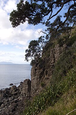
212:. Ti Point is situated very close to Leigh and Goat Island, and is just over one hour drive north of Auckland. It is used for fishing, boating, hiking, rock climbing and yachting, and is under governance of the Rodney District Council, just north of
257:
Statistics New
Zealand describes Ti Point as a rural settlement, which covers 2.29 km (0.88 sq mi) and had an estimated population of 150 as of June 2023, with a population density of 66 people per km. Ti Point is part of the larger
801:
240:
inhabitants of Ti Point, though there were thriving communities all around, in what would become Leigh and Omaha. The remains of an ancient Pa (a fortified camp or village) can be seen just above the point itself.
794:
787:
343:
Although some people chose not to answer the census's question about religious affiliation, 79.5% had no religion, 11.4% were
Christian and 4.5% had other religions.
340:
Ethnicities were 93.2% European/Pākehā, 6.8% Māori, 4.5% Pacific peoples, 2.3% Asian, and 4.5% other ethnicities. People may identify with more than one ethnicity.
359:. Their wines have won gold medals at several wine shows, including the Spiegelau International Wine Competition and the New Zealand International Wine Show.
228:
volcano, which erupted between 10 and 7 million years ago. Much of the peninsula is the eroded and exhumed volcanic plumbing that remains from the volcano.
1235:
1155:
1095:
974:
50:
1250:
549:
705:
681:
600:
519:
379:
in New
Zealand specialising in reptiles. Ivan Borich founded the park in 1972 and still privately owns and operates it as of September 2020.
643:
959:
417:
1245:
843:
1150:
1160:
954:
389:
Although the park specialises and contains predominantly reptiles, the park began as a traditional zoo, and still houses
347:
at least 15 was that 42 (40.0%) people were employed full-time, 21 (20.0%) were part-time, and 3 (2.9%) were unemployed.
1135:
1115:
1100:
1140:
616:
564:
758:
1165:
898:
811:
1172:
1074:
1240:
1213:
1125:
1110:
1105:
1064:
481:
463:
445:
334:
330:
326:
933:
923:
673:
534:
485:
467:
449:
1145:
903:
779:
482:"Subnational population estimates (urban rural), by age and sex, at 30 June 1996-2023 (2023 boundaries)"
32:
1130:
136:
464:"Subnational population estimates (TA, SA2), by age and sex, at 30 June 1996-2023 (2023 boundaries)"
446:"Subnational population estimates (RC, SA2), by age and sex, at 30 June 1996-2023 (2023 boundaries)"
1019:
1014:
999:
367:
The Ti Point
Walkway follows the southern coast of Ti Point, traversing coastal bush and beaches.
1200:
1079:
893:
863:
259:
205:
115:
1044:
949:
1049:
994:
677:
596:
515:
590:
1195:
687:
390:
159:
1120:
1054:
1024:
1004:
356:
209:
95:
237:
1177:
1034:
1009:
984:
969:
908:
868:
141:
731:
1229:
1069:
1059:
853:
507:
989:
964:
913:
858:
848:
1205:
1039:
979:
888:
883:
819:
225:
105:
85:
382:
The park contains a wide variety of reptiles, including tortoise, lizards, and
1029:
928:
838:
213:
65:
52:
691:
355:
Since the late 1990s, wine has been produced at the Ti Point Winery, in the
878:
873:
815:
394:
246:
383:
279:
833:
783:
204:
is an area off Omaha Beach in the small New
Zealand village of
376:
274:
440:
438:
236:
When
Europeans arrived in New Zealand, there were no
1188:
1088:
942:
826:
191:
183:
178:
170:
165:
155:
150:
129:
121:
111:
101:
91:
81:
23:
514:. Geoscience Society of New Zealand. p. 179.
386:– a species of lizard only found in New Zealand.
333:, and an increase of 48 people (57.1%) since the
732:"Creepy critter park in Leigh is a secret gem"
552:. Statistics New Zealand. March 2020. 7001159.
795:
544:
542:
329:, an increase of 27 people (25.7%) since the
8:
550:"Statistical area 1 dataset for 2018 Census"
265:
759:"Day-tripper: Ti Point Reptile Park, Leigh"
802:
788:
780:
264:
224:Ti Point is formed from the remnants of a
20:
1156:Warkworth Radio Astronomical Observatory
1096:Cape Rodney-Okakari Point Marine Reserve
325:Ti Point had a population of 132 at the
975:Challenger Island / Little Kawau Island
406:
177:
164:
149:
128:
80:
45:
41:
29:
595:. ReadHowYouWant.com. pp. 57–60.
535:2018 Census place summary: Cape Rodney
412:
410:
190:
182:
169:
154:
120:
110:
100:
90:
18:Place in Auckland Region, New Zealand
7:
589:Michael Cooper (5 September 2011).
174:2.29 km (0.88 sq mi)
960:Beehive Island / Taungamaro Island
757:Easther, Elisabeth (17 May 2015).
375:Ti Point Reptile Park is the only
156: • Territorial Authority
14:
1214:Rodney District Council (defunct)
706:"Ti Point Reptile Park, Ti Point"
1236:Headlands of the Auckland Region
644:"Marlborough golds at Spiegelau"
249:, at the Matakana Country Park.
31:
1151:Warkworth & District Museum
844:Baddeleys Beach-Campbells Beach
668:Janssen, Peter (January 2021).
512:Out of the Ocean, Into the Fire
1:
1251:Climbing areas of New Zealand
642:Kat Pickford (27 June 2013).
563:Rebecca Gibb (10 May 2011).
260:Cape Rodney statistical area
617:"Marlborough wines triumph"
479:(territorial authorities);
1267:
1089:Facilities and attractions
1136:Tāwharanui Marine Reserve
592:Wine Atlas of New Zealand
318:
292:—
46:
42:
30:
1173:Wenderholm Regional Park
1141:Tāwharanui Regional Park
810:Warkworth Subdivision -
565:"Wine: Working with mum"
418:"ArcGIS Web Application"
66:36.317159°S 174.790026°E
1246:Rodney Local Board Area
1126:Scandrett Regional Park
1111:Mahurangi Regional Park
1106:Leigh Marine Laboratory
422:statsnz.maps.arcgis.com
327:2018 New Zealand census
763:The New Zealand Herald
674:New Holland Publishers
670:Greater Auckland Walks
569:The New Zealand Herald
486:Statistics New Zealand
468:Statistics New Zealand
450:Statistics New Zealand
195:66/km (170/sq mi)
71:-36.317159; 174.790026
1146:Te Muri Regional Park
461:(regional councils);
371:Ti Point Reptile Park
266:Historical population
125:Warkworth subdivision
1131:Smelting House ruins
1065:Tāwharanui Peninsula
357:Matakana wine region
192: • Density
137:Kaipara ki Mahurangi
1161:30m Radio Telescope
1020:Moturekareka Island
1015:Motuketekete Island
1000:Mahurangi Peninsula
943:Geographic features
267:
62: /
1201:Rodney Local Board
1080:Whangateau Harbour
623:. 5 September 2011
184: • Total
171: • Total
116:Rodney Local Board
1223:
1222:
1050:Takangaroa Island
995:Mahurangi Harbour
683:978-1-86966-516-6
602:978-1-4596-2796-3
521:978-0-473-39596-4
508:Hayward, Bruce W.
323:
322:
208:, located in the
199:
198:
1258:
1196:Auckland Council
1101:Holy Name Church
827:Populated places
804:
797:
790:
781:
774:
773:
771:
769:
754:
748:
747:
745:
743:
727:
721:
720:
718:
716:
702:
696:
695:
665:
659:
658:
656:
654:
639:
633:
632:
630:
628:
613:
607:
606:
586:
580:
579:
577:
575:
560:
554:
553:
546:
537:
532:
526:
525:
504:
498:
496:
494:
492:
478:
476:
474:
460:
458:
456:
442:
433:
432:
430:
428:
414:
391:Capuchin monkeys
281:
276:
268:
160:Auckland Council
77:
76:
74:
73:
72:
67:
63:
60:
59:
58:
55:
35:
21:
1266:
1265:
1261:
1260:
1259:
1257:
1256:
1255:
1226:
1225:
1224:
1219:
1184:
1166:Radio Telescope
1121:Pumphouse ruins
1084:
1055:Te Haupa Island
1045:Tāhekeroa River
1025:Motutara Island
1005:Mahurangi River
950:Arapārera River
938:
822:
808:
778:
777:
767:
765:
756:
755:
751:
741:
739:
730:Brown, Justin.
729:
728:
724:
714:
712:
704:
703:
699:
684:
667:
666:
662:
652:
650:
641:
640:
636:
626:
624:
615:
614:
610:
603:
588:
587:
583:
573:
571:
562:
561:
557:
548:
547:
540:
533:
529:
522:
506:
505:
501:
490:
488:
480:
472:
470:
462:
454:
452:
444:
443:
436:
426:
424:
416:
415:
408:
403:
373:
365:
353:
255:
234:
222:
210:Rodney District
146:
112:Community board
96:Auckland Region
70:
68:
64:
61:
56:
53:
51:
49:
48:
38:
26:
19:
12:
11:
5:
1264:
1262:
1254:
1253:
1248:
1243:
1241:Matakana Coast
1238:
1228:
1227:
1221:
1220:
1218:
1217:
1210:
1209:
1208:
1203:
1192:
1190:
1186:
1185:
1183:
1182:
1181:
1180:
1178:Couldrey House
1170:
1169:
1168:
1163:
1153:
1148:
1143:
1138:
1133:
1128:
1123:
1118:
1113:
1108:
1103:
1098:
1092:
1090:
1086:
1085:
1083:
1082:
1077:
1072:
1067:
1062:
1057:
1052:
1047:
1042:
1037:
1032:
1027:
1022:
1017:
1012:
1010:Matakana River
1007:
1002:
997:
992:
987:
982:
977:
972:
970:Casnell Island
967:
962:
957:
955:Archway Island
952:
946:
944:
940:
939:
937:
936:
931:
926:
921:
916:
911:
909:Scotts Landing
906:
901:
896:
891:
886:
881:
876:
871:
869:Mahurangi West
866:
861:
856:
851:
846:
841:
836:
830:
828:
824:
823:
809:
807:
806:
799:
792:
784:
776:
775:
749:
722:
697:
682:
676:. p. 22.
660:
634:
608:
601:
581:
555:
538:
527:
520:
499:
434:
405:
404:
402:
399:
372:
369:
364:
361:
352:
349:
321:
320:
316:
315:
312:
309:
305:
304:
301:
298:
294:
293:
290:
287:
283:
282:
277:
272:
254:
251:
233:
230:
221:
218:
197:
196:
193:
189:
188:
185:
181:
180:
176:
175:
172:
168:
167:
163:
162:
157:
153:
152:
148:
147:
145:
144:
142:Te Tai Tokerau
139:
133:
131:
127:
126:
123:
119:
118:
113:
109:
108:
103:
99:
98:
93:
89:
88:
83:
79:
78:
44:
43:
40:
39:
36:
28:
27:
24:
17:
13:
10:
9:
6:
4:
3:
2:
1263:
1252:
1249:
1247:
1244:
1242:
1239:
1237:
1234:
1233:
1231:
1216:
1215:
1211:
1207:
1204:
1202:
1199:
1198:
1197:
1194:
1193:
1191:
1187:
1179:
1176:
1175:
1174:
1171:
1167:
1164:
1162:
1159:
1158:
1157:
1154:
1152:
1149:
1147:
1144:
1142:
1139:
1137:
1134:
1132:
1129:
1127:
1124:
1122:
1119:
1117:
1116:Mansion House
1114:
1112:
1109:
1107:
1104:
1102:
1099:
1097:
1094:
1093:
1091:
1087:
1081:
1078:
1076:
1075:Waiwera River
1073:
1071:
1070:Mathesons Bay
1068:
1066:
1063:
1061:
1060:Te Kapa River
1058:
1056:
1053:
1051:
1048:
1046:
1043:
1041:
1038:
1036:
1033:
1031:
1028:
1026:
1023:
1021:
1018:
1016:
1013:
1011:
1008:
1006:
1003:
1001:
998:
996:
993:
991:
988:
986:
983:
981:
978:
976:
973:
971:
968:
966:
963:
961:
958:
956:
953:
951:
948:
947:
945:
941:
935:
932:
930:
927:
925:
922:
920:
917:
915:
912:
910:
907:
905:
902:
900:
897:
895:
892:
890:
887:
885:
882:
880:
877:
875:
872:
870:
867:
865:
862:
860:
857:
855:
854:Kaipara Flats
852:
850:
847:
845:
842:
840:
837:
835:
832:
831:
829:
825:
821:
817:
813:
805:
800:
798:
793:
791:
786:
785:
782:
764:
760:
753:
750:
737:
733:
726:
723:
711:
707:
701:
698:
693:
689:
685:
679:
675:
671:
664:
661:
649:
645:
638:
635:
622:
618:
612:
609:
604:
598:
594:
593:
585:
582:
570:
566:
559:
556:
551:
545:
543:
539:
536:
531:
528:
523:
517:
513:
509:
503:
500:
497:(urban areas)
487:
483:
469:
465:
451:
447:
441:
439:
435:
423:
419:
413:
411:
407:
400:
398:
396:
392:
387:
385:
380:
378:
370:
368:
362:
360:
358:
350:
348:
344:
341:
338:
336:
332:
328:
317:
313:
310:
307:
306:
302:
299:
296:
295:
291:
288:
285:
284:
278:
273:
270:
269:
263:
261:
252:
250:
248:
242:
239:
231:
229:
227:
219:
217:
215:
211:
207:
203:
194:
186:
173:
161:
158:
143:
140:
138:
135:
134:
132:
124:
117:
114:
107:
104:
97:
94:
87:
84:
75:
47:Coordinates:
34:
22:
16:
1212:
990:Kawau Island
965:Brazier Rock
918:
914:Snells Beach
899:Rainbows End
859:Kawau Island
766:. Retrieved
762:
752:
740:. Retrieved
735:
725:
713:. Retrieved
709:
700:
669:
663:
651:. Retrieved
647:
637:
625:. Retrieved
620:
611:
591:
584:
572:. Retrieved
568:
558:
530:
511:
502:
489:. Retrieved
471:. Retrieved
453:. Retrieved
425:. Retrieved
421:
388:
381:
374:
366:
354:
345:
342:
339:
324:
256:
253:Demographics
243:
235:
223:
201:
200:
15:
1206:Rodney ward
1040:Puhoi River
1035:Ōmaha River
985:Hōteo River
980:Dome Forest
889:Point Wells
820:New Zealand
351:Wine-making
335:2006 census
331:2013 census
226:Miocene era
130:Electorates
122:Subdivision
106:Rodney ward
86:New Zealand
69: /
57:174°47′24″E
1230:Categories
1189:Government
1030:Omaha Cove
929:Whangateau
839:Algies Bay
738:. Newsroom
692:Q118136068
491:25 October
473:25 October
455:25 October
401:References
214:Whangateau
179:Population
151:Government
54:36°19′02″S
934:Woodcocks
924:Warkworth
849:Big Ōmaha
768:31 August
742:31 August
715:31 August
363:Amenities
919:Ti Point
904:Sandspit
884:Pōhuehue
874:Matakana
816:Auckland
736:Newsroom
710:Auckland
688:Wikidata
653:9 August
627:9 August
574:9 August
510:(2017).
395:Cockatoo
319:Source:
247:Matakana
202:Ti Point
37:Ti Point
25:Ti Point
384:Tuatara
280:±% p.a.
232:History
220:Geology
82:Country
834:Ahuroa
812:Rodney
690:
680:
599:
518:
427:12 May
393:and a
314:+4.68%
303:+3.24%
92:Region
894:Puhoi
879:Ōmaha
864:Leigh
648:Stuff
621:Stuff
238:Māori
206:Leigh
770:2020
744:2020
717:2020
678:ISBN
655:2016
629:2016
597:ISBN
576:2016
516:ISBN
493:2023
475:2023
457:2023
429:2022
308:2018
297:2013
286:2006
275:Pop.
271:Year
166:Area
102:Ward
377:zoo
311:132
300:105
187:150
1232::
818:,
814:,
761:.
734:.
708:.
686:.
672:.
646:.
619:.
567:.
541:^
484:.
466:.
448:.
437:^
420:.
409:^
397:.
289:84
262:.
216:.
803:e
796:t
789:v
772:.
746:.
719:.
694:.
657:.
631:.
605:.
578:.
524:.
495:.
477:.
459:.
431:.
Text is available under the Creative Commons Attribution-ShareAlike License. Additional terms may apply.