137:
144:
29:
411:, but in Mexico they are called the Sierra Tinajas Altas which would suggest that they are a longer extension of the Tinajas Altas Mountains into Mexico. The two ranges, however, share no surface connection so they are not the same. The Sierra de la Lechuguilla/Sierra Tinajas Altas range are instead on a parallel alignment to the southeast of the Tinajas Altas Mountains proper.
380:("High Tanks"), which are a series of perched waterholes on the range's eastern side approximately four miles north of the international boundary. The waterholes figured prominently in the history of the area as they were for many years the only reliable source of water for many miles. Native Americans, principally the Hia C-eḍ O'odham, also utilized the
340:. The range is about 22 mi in length and about 4 mi wide at its widest point. The highpoint of the range is unnamed and is 2,766 feet (843 meters) above sea level and is located at 32°16'26"N, 114°02'48"W (NAD 1983 datum). Aside from the portion of the range in Mexico, the entirety of the range lies within the
399:
and encompasses much of southeastern
California, southwestern Arizona, northwestern Sonora, and northeastern Baja California. The subdivision is characterized by minimal precipitation, and the area around the Tinajas Altas Mountains averages only about three inches of rainfall per year.
2073:
407:(USGS) maps of the region disagree on the name of an adjacent range lying to the southeast of the Tinajas Altas Mountains. In the United States this small range is referred to as the
454:
363:, and what are now the Tinajas Altas Mountains were actually considered part of the Gila Mountains until about the middle of the 20th century. The two ranges are separated by
2083:
474:
2078:
660:
499:
464:
1542:
136:
618:
1552:
235:
2063:
1762:
599:
371:, 2,694 feet (821 m) which is a notable dark-colored volcanic feature on the eastern flank of the otherwise light-colored granitic range.
1617:
1557:
1702:
2068:
1441:
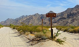
2088:
1547:
951:
653:
469:
341:
38:
1423:
669:
1572:
882:
62:
404:
1662:
1607:
1537:
646:
2093:
1952:
1857:
1667:
1577:
1562:
1173:
677:
360:
270:
228:
623:
1902:
1792:
1767:
1682:
1507:
388:
2032:
1957:
1752:
1732:
1336:
489:
415:
221:
1812:
1433:
1035:
697:
633:
1717:
1602:
1300:
1236:
1025:
915:
634:
Vehicle Trails
Associated with Illegal Border Activities on Cabeza Prieta National Wildlife Refuge – July 2011
628:
525:
Our Grand Desert: A Gazetteer for
Northwestern Sonora, Southwestern Arizona, and Northeastern Baja California.
408:
345:
1932:
1882:
1872:
1772:
1737:
1587:
1472:
1400:
1277:
1244:
1002:
984:
449:
1852:
1687:
1652:
1527:
1482:
1346:
1318:
1292:
1163:
833:
715:
337:
282:
201:
1942:
1912:
1832:
1632:
1451:
1359:
864:
743:
733:
494:
1068:
593:
332:. The southern end of the range extends approximately one mile into the northwestern Mexican state of
2042:
2037:
2002:
1777:
1757:
1712:
1622:
1517:
1477:
1382:
1269:
897:
779:
381:
376:
325:
211:
34:
1987:
1962:
1917:
1877:
1862:
1842:
1837:
1782:
1672:
1657:
1642:
1627:
1492:
1415:
1181:
1145:
1094:
1040:
923:
751:
436:
364:
313:
2022:
1922:
1907:
1797:
1707:
1532:
1497:
1487:
1446:
1020:
969:
961:
938:
874:
851:
725:
710:
459:
368:
294:
278:
2012:
2017:
1982:
1897:
1867:
1822:
1817:
1692:
1677:
1647:
1597:
1522:
1221:
1104:
1086:
1012:
815:
2027:
2007:
1807:
1802:
1787:
1612:
1392:
1122:
797:
761:
42:
1992:
1927:
1827:
1567:
1282:
1050:
787:
687:
603:
396:
1206:
1997:
1747:
1742:
1374:
1364:
1354:
1191:
994:
979:
928:
479:
392:
193:
2057:
1887:
1328:
1226:
1196:
1186:
1130:
1030:
974:
887:
841:
705:
329:
169:
1972:
1937:
1892:
1847:
1697:
1592:
1512:
1502:
1467:
1405:
1310:
1259:
1249:
1211:
1153:
1076:
769:
484:
28:
1967:
1727:
1254:
1201:
1135:
823:
504:
357:
324:) are an extremely arid northwest–southeast trending mountain range in southern
274:
197:
356:
Geologically, the
Tinajas Altas Mountains are a southeastward extension of the
1947:
1722:
1216:
1158:
1058:
946:
805:
250:
237:
77:
64:
1582:
1112:
859:
523:
Broyles, Bill, Luke Evans, Richard
Stephen Felger, and Gary Nabhan. 2007.
905:
1637:
638:
299:
183:
367:, also referred to as "Smugglers Pass," about two miles northwest of
333:
173:
94:
440:), which species exhibits a contorted multi-furcate architecture.
431:
427:
434:
species. Among the notable flora present is the elephant tree, (
642:
531:, Broyles, B. and R. Felger, editors. University of Utah Press.
418:
in the east of the Yuma Valley adjacent to the Gila
Mountains.
344:. They lie at the heart of the traditional homeland of the
529:
Dry
Borders: Great Natural Reserves of the Sonoran Desert
579:
Direccion
General de Geografia del Territorio Nacional.
414:
The closest community to the
Tinajas Altas Mountains is
455:
El
Pinacate y Gran Desierto de Altar Biosphere Reserve
1460:
1432:
1414:
1391:
1373:
1345:
1327:
1309:
1291:
1268:
1235:
1172:
1144:
1121:
1103:
1085:
1067:
1049:
1011:
993:
960:
937:
914:
896:
873:
850:
832:
814:
796:
778:
760:
742:
724:
696:
676:
570:. 7.5-minute Series (Topographic). Reston, Virginia
395:. This subdivision is sometimes referred to as the
384:as an important camp prior to European settlement.
293:
288:
266:
227:
217:
207:
189:
179:
165:
124:
116:
108:
103:
93:
55:
50:
21:
16:
Landform in Yuma County, Arizona and Sonora, Mexico
2074:Mountain ranges of the Lower Colorado River Valley
426:The Tinajas Altas Mountains exhibit a variety of
629:Cabeza Prieta National Wildlife Refuge - Arizona
557:15-minute Series (Topographic). Washington, D.C.
540:Sellers, William D. and Richard H. Hill. 1974.
475:List of mountain ranges of Yuma County, Arizona
143:
500:Valley and range sequence-Southern Yuma County
465:List of LCRV Wilderness Areas (Colorado River)
654:
583:. 1:50000 scale topographic map. Mexico, D.F.
544:University of Arizona Press. Tucson, Arizona.
8:
661:
647:
639:
18:
619:Border Patrol: Along the Devil's Highway
568:Tinajas Altas Quadrangle, Arizona-Sonora
328:, approximately 35 mi southeast of
2084:Mountain ranges of Yuma County, Arizona
516:
624:Cabeza Prieta National Wildlife Refuge
597:, GlobalTwitcher.com, ed. N. Stromberg
2079:Mountain ranges of the Sonoran Desert
7:
1543:Black Mesa (Apache-Navajo Counties)
1578:Buckskin Mountains (La Paz County)
595:Elephant Tree: Bursera microphylla
555:Tinajas Altas Quadrangle, Arizona.
470:List of mountain ranges of Arizona
342:Barry M. Goldwater Air Force Range
39:Barry M. Goldwater Air Force Range
14:
336:on the northern perimeter of the
1573:Buckskin Mountain (Arizona-Utah)
1553:Black Mountain (Maricopa County)
142:
135:
45:, at spur road to Tinajas Altas.
27:
2064:History of Yuma County, Arizona
1763:Lime Mountain (Maricopa County}
405:United States Geological Survey
1663:Gila Mountains (Graham County)
566:U.S. Geological Survey. 1996.
553:U.S. Geological Survey. 1965.
1:
1538:Black Hills (Greenlee County)
403:Mexican topographic maps and
1668:Gila Mountains (Yuma County)
1558:Black Mountain (Pima County)
1174:San Francisco Volcanic Field
271:Gila Mountains (Yuma County)
1768:Little Harquahala Mountains
542:Arizona Climate: 1931-1972.
374:The range is named for the
2110:
2069:Mountain ranges of Arizona
2033:West Silver Bell Mountains
1733:John the Baptist Mountains
1442:Black Mesa (Navajo County)
490:Tinajas Altas (High Tanks)
222:Fortuna Foothills, Arizona
99:843 m (2,766 ft)
2089:Mountain ranges of Mexico
1548:Black Mesa (Warm Springs)
581:Mina del Desierto, Sonora
129:
120:6.4 km (4.0 mi)
26:
1603:Cerro Colorado Mountains
1237:Santa Catalina Mountains
916:Little Dragoon Mountains
592:C. Michael Hogan. 2009.
409:Sierra de la Lechuguilla
1978:Tinajas Altas Mountains
1933:Sierra Madre Occidental
1773:Little Rincon Mountains
1588:Cabeza Prieta Mountains
1473:Agua Caliente Mountains
1003:Mount Ballard (Arizona)
450:Cabeza Prieta Mountains
310:Tinajas Altas Mountains
156:Tinajas Altas Mountains
150:Tinajas Altas Mountains
112:35 km (22 mi)
22:Tinajas Altas Mountains
1853:Painted Rock Mountains
1688:Granite Wash Mountains
1528:Bill Williams Mountain
1347:Superstition Mountains
1293:Santa Teresa Mountains
834:Hieroglyphic Mountains
387:The range lies in the
338:Gran Desierto de Altar
302:–(light-colored)
283:Gran Desierto de Altar
202:Gran Desierto de Altar
78:32.27389°N 114.04667°W
1943:Silver Bell Mountains
1913:Santa Maria Mountains
1633:Dos Cabezas Mountains
1360:Superstition Mountain
744:Castle Dome Mountains
495:Tule Desert (Arizona)
352:Geology and geography
251:32.2833333°N 114.05°W
2043:Wickenburg Mountains
2038:White Tank Mountains
2003:Tumacacori Mountains
1778:Lukachukai Mountains
1758:Las Guijas Mountains
1713:Harquahala Mountains
1623:Date Creek Mountains
1518:Beaver Dam Mountains
1478:Agua Dulce Mountains
1270:Santa Rita Mountains
898:Little Ajo Mountains
780:Chiricahua Mountains
670:Mountains of Arizona
326:Yuma County, Arizona
212:Yuma County, Arizona
83:32.27389; -114.04667
35:El Camino Del Diablo
2094:Landforms of Sonora
1988:Tortolita Mountains
1963:Swisshelm Mountains
1918:Sevenmile Mountains
1878:Picketpost Mountain
1863:Patagonia Mountains
1843:New Water Mountains
1838:New River Mountains
1783:Madrean Sky Islands
1703:Guadalupe Mountains
1673:Goldfield Mountains
1658:Gila Bend Mountains
1628:Dome Rock Mountains
1608:Chocolate Mountains
1563:Blackjack Mountains
1493:Artillery Mountains
1416:Whetstone Mountains
1182:Black Bottom Crater
1146:San Francisco Peaks
1041:Sunnyslope Mountain
437:Bursera microphylla
391:subdivision of the
256:32.2833333; -114.05
247: /
74: /
2023:Waterman Mountains
1953:Sugarloaf Mountain
1923:Sierra San Antonio
1908:San Luis Mountains
1858:Pajarito Mountains
1798:Moccasin Mountains
1708:Harcuvar Mountains
1533:Bitsihuitsos Butte
1498:Atascosa Mountains
1488:Aquarius Mountains
1447:Escudilla Mountain
1069:Pinaleño Mountains
1021:Camelback Mountain
962:McDowell Mountains
939:Mazatzal Mountains
875:Hualapai Mountains
852:Huachuca Mountains
726:Bradshaw Mountains
711:Fortification Hill
602:2012-03-07 at the
460:Lechuguilla Desert
279:Lechuguilla Desert
51:Highest point
2051:
2050:
2018:Vulture Mountains
1983:Tordillo Mountain
1903:Sacaton Mountains
1898:Rawhide Mountains
1868:Peacock Mountains
1823:Mustang Mountains
1818:Muggins Mountains
1793:Mineral Mountains
1693:Growler Mountains
1683:Granite Mountains
1678:Grand Wash Cliffs
1648:Galiuro Mountains
1598:Carrizo Mountains
1523:Belmont Mountains
1222:Strawberry Crater
1105:Quinlan Mountains
1087:Plomosa Mountains
1013:Phoenix Mountains
816:Dragoon Mountains
416:Fortuna Foothills
306:
305:
229:Range coordinates
2101:
2028:Weaver Mountains
2008:Virgin Mountains
1958:Sunset Mountains
1808:Mohawk Mountains
1803:Mohave Mountains
1788:Mescal Mountains
1753:Laguna Mountains
1618:Coyote Mountains
1613:Copper Mountains
1508:Baboquivari Peak
1393:Tucson Mountains
1337:Granite Mountain
1123:Rincon Mountains
798:Chuska Mountains
762:Cerbat Mountains
680:(Yavapai County)
663:
656:
649:
640:
606:
590:
584:
577:
571:
564:
558:
551:
545:
538:
532:
521:
346:Hia C-eḍ O'odham
262:
261:
259:
258:
257:
252:
248:
245:
244:
243:
240:
146:
145:
139:
89:
88:
86:
85:
84:
79:
75:
72:
71:
70:
67:
43:Wellton, Arizona
31:
19:
2109:
2108:
2104:
2103:
2102:
2100:
2099:
2098:
2054:
2053:
2052:
2047:
2013:Vulcan's Throne
1993:Trigo Mountains
1928:Sierra Estrella
1828:Navajo Mountain
1568:Bryan Mountains
1456:
1434:White Mountains
1428:
1410:
1387:
1369:
1341:
1323:
1305:
1287:
1283:Mount Wrightson
1264:
1231:
1168:
1140:
1117:
1099:
1081:
1063:
1051:Pinal Mountains
1045:
1036:South Mountains
1007:
989:
956:
933:
910:
892:
869:
846:
828:
810:
792:
788:Chiricahua Peak
774:
756:
738:
720:
698:Black Mountains
692:
688:Mingus Mountain
679:
672:
667:
615:
613:Further reading
610:
609:
604:Wayback Machine
591:
587:
578:
574:
565:
561:
552:
548:
539:
535:
522:
518:
513:
446:
424:
397:Colorado Desert
354:
255:
253:
249:
246:
241:
238:
236:
234:
233:
161:
160:
159:
158:
157:
154:
153:
152:
151:
147:
82:
80:
76:
73:
68:
65:
63:
61:
60:
46:
17:
12:
11:
5:
2107:
2105:
2097:
2096:
2091:
2086:
2081:
2076:
2071:
2066:
2056:
2055:
2049:
2048:
2046:
2045:
2040:
2035:
2030:
2025:
2020:
2015:
2010:
2005:
2000:
1998:Tule Mountains
1995:
1990:
1985:
1980:
1975:
1970:
1965:
1960:
1955:
1950:
1945:
1940:
1935:
1930:
1925:
1920:
1915:
1910:
1905:
1900:
1895:
1890:
1885:
1880:
1875:
1870:
1865:
1860:
1855:
1850:
1845:
1840:
1835:
1830:
1825:
1820:
1815:
1813:Mount Trumbull
1810:
1805:
1800:
1795:
1790:
1785:
1780:
1775:
1770:
1765:
1760:
1755:
1750:
1748:Kofa Mountains
1745:
1743:Kaibab Plateau
1740:
1735:
1730:
1725:
1720:
1718:House Mountain
1715:
1710:
1705:
1700:
1695:
1690:
1685:
1680:
1675:
1670:
1665:
1660:
1655:
1650:
1645:
1640:
1635:
1630:
1625:
1620:
1615:
1610:
1605:
1600:
1595:
1590:
1585:
1580:
1575:
1570:
1565:
1560:
1555:
1550:
1545:
1540:
1535:
1530:
1525:
1520:
1515:
1510:
1505:
1500:
1495:
1490:
1485:
1480:
1475:
1470:
1464:
1462:
1458:
1457:
1455:
1454:
1449:
1444:
1438:
1436:
1430:
1429:
1427:
1426:
1420:
1418:
1412:
1411:
1409:
1408:
1403:
1397:
1395:
1389:
1388:
1386:
1385:
1379:
1377:
1375:Tank Mountains
1371:
1370:
1368:
1367:
1365:Weavers Needle
1362:
1357:
1355:Silly Mountain
1351:
1349:
1343:
1342:
1340:
1339:
1333:
1331:
1325:
1324:
1322:
1321:
1315:
1313:
1307:
1306:
1304:
1303:
1301:Mount Turnbull
1297:
1295:
1289:
1288:
1286:
1285:
1280:
1274:
1272:
1266:
1265:
1263:
1262:
1257:
1252:
1247:
1241:
1239:
1233:
1232:
1230:
1229:
1224:
1219:
1214:
1209:
1204:
1199:
1194:
1192:Humphreys Peak
1189:
1184:
1178:
1176:
1170:
1169:
1167:
1166:
1161:
1156:
1150:
1148:
1142:
1141:
1139:
1138:
1133:
1127:
1125:
1119:
1118:
1116:
1115:
1109:
1107:
1101:
1100:
1098:
1097:
1091:
1089:
1083:
1082:
1080:
1079:
1073:
1071:
1065:
1064:
1062:
1061:
1055:
1053:
1047:
1046:
1044:
1043:
1038:
1033:
1028:
1026:Mummy Mountain
1023:
1017:
1015:
1009:
1008:
1006:
1005:
999:
997:
995:Mule Mountains
991:
990:
988:
987:
982:
980:Mount McDowell
977:
972:
966:
964:
958:
957:
955:
954:
949:
943:
941:
935:
934:
932:
931:
929:Mae West Peaks
926:
920:
918:
912:
911:
909:
908:
902:
900:
894:
893:
891:
890:
885:
879:
877:
871:
870:
868:
867:
862:
856:
854:
848:
847:
845:
844:
838:
836:
830:
829:
827:
826:
820:
818:
812:
811:
809:
808:
802:
800:
794:
793:
791:
790:
784:
782:
776:
775:
773:
772:
766:
764:
758:
757:
755:
754:
748:
746:
740:
739:
737:
736:
730:
728:
722:
721:
719:
718:
713:
708:
702:
700:
694:
693:
691:
690:
684:
682:
674:
673:
668:
666:
665:
658:
651:
643:
637:
636:
631:
626:
621:
614:
611:
608:
607:
585:
572:
559:
546:
533:
515:
514:
512:
509:
508:
507:
502:
497:
492:
487:
482:
480:Pinacate Peaks
477:
472:
467:
462:
457:
452:
445:
442:
423:
420:
393:Sonoran Desert
389:Lower Colorado
361:Gila Mountains
353:
350:
304:
303:
297:
291:
290:
286:
285:
268:
264:
263:
231:
225:
224:
219:
215:
214:
209:
205:
204:
194:Sonoran Desert
191:
187:
186:
181:
177:
176:
167:
163:
162:
155:
149:
148:
141:
140:
134:
133:
132:
131:
130:
127:
126:
122:
121:
118:
114:
113:
110:
106:
105:
101:
100:
97:
91:
90:
57:
53:
52:
48:
47:
32:
24:
23:
15:
13:
10:
9:
6:
4:
3:
2:
2106:
2095:
2092:
2090:
2087:
2085:
2082:
2080:
2077:
2075:
2072:
2070:
2067:
2065:
2062:
2061:
2059:
2044:
2041:
2039:
2036:
2034:
2031:
2029:
2026:
2024:
2021:
2019:
2016:
2014:
2011:
2009:
2006:
2004:
2001:
1999:
1996:
1994:
1991:
1989:
1986:
1984:
1981:
1979:
1976:
1974:
1971:
1969:
1966:
1964:
1961:
1959:
1956:
1954:
1951:
1949:
1946:
1944:
1941:
1939:
1936:
1934:
1931:
1929:
1926:
1924:
1921:
1919:
1916:
1914:
1911:
1909:
1906:
1904:
1901:
1899:
1896:
1894:
1891:
1889:
1888:Poachie Range
1886:
1884:
1883:Pinnacle Peak
1881:
1879:
1876:
1874:
1871:
1869:
1866:
1864:
1861:
1859:
1856:
1854:
1851:
1849:
1846:
1844:
1841:
1839:
1836:
1834:
1831:
1829:
1826:
1824:
1821:
1819:
1816:
1814:
1811:
1809:
1806:
1804:
1801:
1799:
1796:
1794:
1791:
1789:
1786:
1784:
1781:
1779:
1776:
1774:
1771:
1769:
1766:
1764:
1761:
1759:
1756:
1754:
1751:
1749:
1746:
1744:
1741:
1739:
1736:
1734:
1731:
1729:
1726:
1724:
1721:
1719:
1716:
1714:
1711:
1709:
1706:
1704:
1701:
1699:
1696:
1694:
1691:
1689:
1686:
1684:
1681:
1679:
1676:
1674:
1671:
1669:
1666:
1664:
1661:
1659:
1656:
1654:
1651:
1649:
1646:
1644:
1641:
1639:
1636:
1634:
1631:
1629:
1626:
1624:
1621:
1619:
1616:
1614:
1611:
1609:
1606:
1604:
1601:
1599:
1596:
1594:
1591:
1589:
1586:
1584:
1581:
1579:
1576:
1574:
1571:
1569:
1566:
1564:
1561:
1559:
1556:
1554:
1551:
1549:
1546:
1544:
1541:
1539:
1536:
1534:
1531:
1529:
1526:
1524:
1521:
1519:
1516:
1514:
1511:
1509:
1506:
1504:
1501:
1499:
1496:
1494:
1491:
1489:
1486:
1484:
1483:Antelope Hill
1481:
1479:
1476:
1474:
1471:
1469:
1466:
1465:
1463:
1459:
1453:
1450:
1448:
1445:
1443:
1440:
1439:
1437:
1435:
1431:
1425:
1422:
1421:
1419:
1417:
1413:
1407:
1404:
1402:
1401:Sentinel Peak
1399:
1398:
1396:
1394:
1390:
1384:
1381:
1380:
1378:
1376:
1372:
1366:
1363:
1361:
1358:
1356:
1353:
1352:
1350:
1348:
1344:
1338:
1335:
1334:
1332:
1330:
1329:Sierra Prieta
1326:
1320:
1317:
1316:
1314:
1312:
1308:
1302:
1299:
1298:
1296:
1294:
1290:
1284:
1281:
1279:
1278:Mount Hopkins
1276:
1275:
1273:
1271:
1267:
1261:
1258:
1256:
1253:
1251:
1248:
1246:
1245:Mount Bigelow
1243:
1242:
1240:
1238:
1234:
1228:
1227:Sunset Crater
1225:
1223:
1220:
1218:
1215:
1213:
1210:
1208:
1205:
1203:
1200:
1198:
1197:Kendrick Peak
1195:
1193:
1190:
1188:
1187:Double Crater
1185:
1183:
1180:
1179:
1177:
1175:
1171:
1165:
1162:
1160:
1157:
1155:
1152:
1151:
1149:
1147:
1143:
1137:
1134:
1132:
1131:Mica Mountain
1129:
1128:
1126:
1124:
1120:
1114:
1111:
1110:
1108:
1106:
1102:
1096:
1093:
1092:
1090:
1088:
1084:
1078:
1075:
1074:
1072:
1070:
1066:
1060:
1057:
1056:
1054:
1052:
1048:
1042:
1039:
1037:
1034:
1032:
1031:Piestewa Peak
1029:
1027:
1024:
1022:
1019:
1018:
1016:
1014:
1010:
1004:
1001:
1000:
998:
996:
992:
986:
985:Thompson Peak
983:
981:
978:
976:
975:McDowell Peak
973:
971:
968:
967:
965:
963:
959:
953:
950:
948:
945:
944:
942:
940:
936:
930:
927:
925:
922:
921:
919:
917:
913:
907:
904:
903:
901:
899:
895:
889:
888:Hualapai Peak
886:
884:
881:
880:
878:
876:
872:
866:
863:
861:
858:
857:
855:
853:
849:
843:
842:White Picacho
840:
839:
837:
835:
831:
825:
822:
821:
819:
817:
813:
807:
804:
803:
801:
799:
795:
789:
786:
785:
783:
781:
777:
771:
768:
767:
765:
763:
759:
753:
750:
749:
747:
745:
741:
735:
732:
731:
729:
727:
723:
717:
714:
712:
709:
707:
706:Boundary Cone
704:
703:
701:
699:
695:
689:
686:
685:
683:
681:
675:
671:
664:
659:
657:
652:
650:
645:
644:
641:
635:
632:
630:
627:
625:
622:
620:
617:
616:
612:
605:
601:
598:
596:
589:
586:
582:
576:
573:
569:
563:
560:
556:
550:
547:
543:
537:
534:
530:
526:
520:
517:
510:
506:
503:
501:
498:
496:
493:
491:
488:
486:
483:
481:
478:
476:
473:
471:
468:
466:
463:
461:
458:
456:
453:
451:
448:
447:
443:
441:
439:
438:
433:
429:
421:
419:
417:
412:
410:
406:
401:
398:
394:
390:
385:
383:
379:
378:
377:Tinajas Altas
372:
370:
366:
365:Cipriano Pass
362:
359:
358:block faulted
351:
349:
347:
343:
339:
335:
331:
330:Yuma, Arizona
327:
323:
319:
315:
311:
301:
298:
296:
292:
287:
284:
280:
276:
272:
269:
265:
260:
232:
230:
226:
223:
220:
216:
213:
210:
206:
203:
199:
195:
192:
188:
185:
182:
178:
175:
171:
170:United States
168:
164:
138:
128:
123:
119:
115:
111:
107:
102:
98:
96:
92:
87:
59:Unnamed,
58:
54:
49:
44:
40:
36:
30:
25:
20:
1977:
1973:Temple Butte
1938:Sierra Pinta
1893:Poston Butte
1873:Picacho Peak
1848:Newton Butte
1738:Juniper Mesa
1698:Gu Achi Peak
1653:Gavilan Peak
1593:Canelo Hills
1513:Balakai Mesa
1503:Aubrey Hills
1468:Agathla Peak
1406:Tumamoc Hill
1319:Mistake Peak
1311:Sierra Ancha
1260:Thimble Peak
1250:Mount Lemmon
1212:Roden Crater
1207:O'Leary Peak
1164:Fremont Peak
1154:Agassiz Peak
1077:Mount Graham
770:Mount Tipton
716:Mount Wilson
594:
588:
580:
575:
567:
562:
554:
549:
541:
536:
528:
524:
519:
485:Sierra Pinta
435:
425:
413:
402:
386:
375:
373:
355:
321:
317:
309:
307:
295:Type of rock
1968:Tempe Butte
1833:The Needles
1728:Isis Temple
1452:Mount Baldy
1424:Apache Peak
1255:Pusch Ridge
1202:Mount Elden
1136:Rincon Peak
883:Aubrey Peak
865:Miller Peak
824:Mount Glenn
752:Castle Dome
734:Mount Union
678:Black Hills
505:Yuma Desert
369:Raven Butte
275:Yuma Desert
254: /
242:114°03′00″W
198:Yuma Desert
81: /
69:114°02′48″W
33:Sign along
2058:Categories
1948:Squaw Tits
1723:Hunts Mesa
1383:Black Dome
1217:S P Crater
1159:Doyle Peak
1059:Pinal Peak
947:Four Peaks
806:Roof Butte
511:References
382:waterholes
322:Uʼuv Oopad
267:Borders on
239:32°17′00″N
218:Settlement
104:Dimensions
66:32°16′26″N
1643:Excalibur
1583:Bush Head
1113:Kitt Peak
1095:Ibex Peak
952:Mount Ord
924:Lime Peak
860:Carr Peak
166:Countries
125:Geography
95:Elevation
970:East End
906:Ajo Peak
600:Archived
444:See also
348:people.
208:District
1638:Etoi Ki
422:Ecology
318:Uʼuva:k
314:O'odham
300:granite
289:Geology
190:Regions
184:Arizona
41:, near
1461:Others
334:Sonora
174:Mexico
109:Length
432:fauna
428:flora
180:State
117:Width
430:and
308:The
281:and
200:and
172:and
56:Peak
527:In
320:or
37:in
2060::
316::
277:,
273:,
196:,
662:e
655:t
648:v
312:(
Text is available under the Creative Commons Attribution-ShareAlike License. Additional terms may apply.