31:
457:
181:
190:
44:
1019:
250:, National Park Service. The Park Service located low-quality farmlands with high-quality park potential. Along the Tippecanoe River, the Federal Government purchased 7,353 acres (2,976 ha). The high sand content of the soil made these poor-quality farmlands. The riverway and forest made it quality parklands. Development of the Demonstration Area was undertaken by the
51:
1045:
254:. In 1943, the property was transferred to the State of Indiana's Department of Conservation as a state park. On January 1, 1959, 4,592 acres (1,858 ha) were transferred to the Division of Fish and Wildlife as the Winamac Fish and Wildlife Area. The state park retains 2,761 acres (1,117 ha) of the original development.
289:
There are ten miles (16 km) of hiking trails and thirteen miles (20 km) of horseback trails. Cultural arts programs and a seasonal naturalist are also available. Most visitors drive to the park, although pilots can land at the nearby
582:
635:
660:
492:
1081:
331:
Horseback riding – trails and a primitive campground are available to horsemen and -women. There are 14.5 miles (23.3 km) of shared hiking and horse trails in the park.
1086:
265:
is very popular in the park, as the
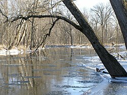
Tippecanoe River stretches seven miles (11 km) along the park's borders. A canoe-exclusive campsite has ten sites. It is also a
592:
1071:
521:
485:
43:
1037:
951:
531:
154:
96:
964:
733:
645:
999:
577:
501:
901:
1049:
1023:
984:
828:
695:
478:
896:
994:
989:
959:
572:
536:
891:
974:
1076:
969:
778:
748:
705:
675:
546:
243:
911:
1030:
1004:
979:
858:
216:
215:
gifted the land to
Indiana's Department of Conservation land to form a state park; other land along the river becoming the
868:
680:
251:
916:
931:
788:
753:
277:
are commonly fished from the river. The river is too dangerous for swimming, so those camping in the park can go to the
89:
921:
886:
720:
526:
630:
600:
247:
382:
30:
768:
758:
625:
610:
564:
450:
174:
941:
808:
803:
743:
728:
554:
204:
67:
278:
881:
853:
833:
823:
738:
605:
189:
848:
843:
690:
513:
212:
936:
926:
700:
266:
226:
trees, the park also preserves more than 2 miles (3 km) of undisturbed wetland shoreline on the
906:
818:
793:
763:
685:
291:
208:
876:
798:
773:
223:
435:
Tippecanoe River State Park, Indiana
Department of Natural Resources; Indianapolis, Indiana 2008
813:
783:
665:
239:
227:
82:
710:
640:
456:
334:
Hiking – a total of 19.1 miles (30.7 km) of trails are located throughout the park.
180:
1065:
655:
650:
620:
357:
is along the river near the center of the park. It is accessible on Trail #4, the
383:"2018 / 2019 Estimated Fiscal Year Visits for Indiana State Parks ~ Alphabetical"
670:
463:
274:
615:
200:
470:
111:
98:
270:
262:
207:, United States. It is located 58 miles (93 km) south-southwest of
505:
71:
347:
is located at the end of the park and is accessible on Trail #8, the
188:
406:
474:
306:
Camping – There are five camping experiences to choose from.
303:
Boating – the park has a small boat launch on the river
242:
of the 1930s, the national government established the
377:
375:
950:
867:
719:
591:
563:
545:
512:
168:
160:
150:
135:
127:
88:
78:
63:
50:
23:
230:, attracting some 127,495 visitors in 2018–2019.
294:and have a courtesy car take them to the park.
486:
8:
522:George Rogers Clark National Historical Park
1082:Protected areas of Pulaski County, Indiana
493:
479:
471:
455:
431:
429:
427:
425:
423:
421:
419:
417:
415:
409:Official (Indiana) DNR Historical Timeline
179:
20:
691:Rocky Hollow-Falls Canyon Nature Preserve
388:. Indiana Department of Natural Resources
1087:Works Progress Administration in Indiana
611:Calvert and Porter Woods Nature Preserve
1038:Indiana Department of Natural Resources
532:Lewis and Clark National Historic Trail
371:
155:Indiana Department of Natural Resources
16:State park in Pulaski County, Indiana
7:
1044:
1072:Protected areas established in 1943
661:Ohio Coral Reef (Falls of the Ohio)
14:
537:Lincoln Boyhood National Memorial
211:. It was formed in 1943 when the
1043:
1018:
1017:
355:Tippecanoe River Nature Preserve
222:Noted for a grove of old-growth
62:
49:
42:
29:
676:Pioneer Mothers Memorial Forest
621:Donaldson Cave System and Woods
244:Recreational Demonstration Area
164:127,495 (in 2018–2019)
149:
126:
407:http://www.in.gov/dnr/3245.htm
217:Winamac Fish and Wildlife Area
1:
952:State Fish and Wildlife Areas
681:Portland Arch Nature Preserve
281:five miles (8 km) away.
252:Works Progress Administration
696:Tamarack Bog Nature Preserve
636:Hanging Rock and Wabash Reef
464:"Indiana Campgrounds Online"
323:Canoe camping from the river
527:Indiana Dunes National Park
131:2,761 acres (1,117 ha)
24:Tippecanoe River State Park
1103:
631:Fern Cliff Nature Preserve
593:National Natural Landmarks
248:Department of the Interior
1013:
565:National Wildlife Refuges
345:Sand Hill Nature Preserve
37:
28:
666:Pine Hills Natural Area
205:Pulaski County, Indiana
1077:State parks of Indiana
606:Cabin Creek Raised Bog
193:
626:Dunes Nature Preserve
514:National Park Service
314:Potawatomi Group Camp
279:Bass Lake State Beach
213:National Park Service
192:
706:Wesselman Park Woods
859:Whitewater Memorial
686:Rise at Orangeville
209:South Bend, Indiana
108: /
902:Jackson–Washington
701:Wesley Chapel Gulf
194:
112:41.1223°N 86.583°W
1059:
1058:
897:Harrison–Crawford
779:McCormick's Creek
754:Falls of the Ohio
320:Rent-a-camp cabin
285:Enjoying the park
187:
186:
79:Nearest city
1094:
1047:
1046:
1021:
1020:
839:Tippecanoe River
601:Big Walnut Creek
495:
488:
481:
472:
467:
459:
454:
453:
451:Official website
436:
433:
410:
404:
398:
397:
395:
393:
387:
379:
240:Great Depression
228:Tippecanoe River
197:Tippecanoe River
183:
178:
177:
175:Official website
151:Operated by
146:
144:
123:
122:
120:
119:
118:
117:41.1223; -86.583
113:
109:
106:
105:
104:
101:
83:Winamac, Indiana
53:
52:
46:
33:
21:
1102:
1101:
1097:
1096:
1095:
1093:
1092:
1091:
1062:
1061:
1060:
1055:
1009:
946:
932:Salamonie River
892:Greene–Sullivan
863:
715:
646:Hoosier Prairie
641:Harrison Spring
587:
559:
547:National Forest
541:
508:
502:Protected areas
499:
462:
449:
448:
445:
440:
439:
434:
413:
405:
401:
391:
389:
385:
381:
380:
373:
368:
341:
339:Protected areas
287:
260:
236:
173:
172:
142:
140:
116:
114:
110:
107:
102:
99:
97:
95:
94:
74:, United States
59:
58:
57:
56:
55:
54:
17:
12:
11:
5:
1100:
1098:
1090:
1089:
1084:
1079:
1074:
1064:
1063:
1057:
1056:
1054:
1053:
1041:
1034:
1027:
1014:
1011:
1010:
1008:
1007:
1002:
997:
992:
987:
982:
977:
972:
967:
965:Jasper–Pulaski
962:
956:
954:
948:
947:
945:
944:
939:
934:
929:
924:
919:
914:
909:
904:
899:
894:
889:
887:Frances Slocum
884:
879:
873:
871:
865:
864:
862:
861:
856:
851:
846:
841:
836:
831:
826:
821:
816:
811:
806:
801:
796:
791:
789:O'Bannon Woods
786:
781:
776:
771:
766:
761:
756:
751:
746:
741:
736:
731:
725:
723:
717:
716:
714:
713:
711:Wyandotte Cave
708:
703:
698:
693:
688:
683:
678:
673:
668:
663:
658:
653:
648:
643:
638:
633:
628:
623:
618:
613:
608:
603:
597:
595:
589:
588:
586:
585:
580:
575:
569:
567:
561:
560:
558:
557:
551:
549:
543:
542:
540:
539:
534:
529:
524:
518:
516:
510:
509:
500:
498:
497:
490:
483:
475:
469:
468:
460:
444:
443:External links
441:
438:
437:
411:
399:
370:
369:
367:
364:
363:
362:
352:
349:Bluestem Trail
340:
337:
336:
335:
332:
329:
325:
324:
321:
318:
315:
312:
311:Family camping
308:
307:
304:
286:
283:
269:release area.
259:
256:
235:
232:
185:
184:
170:
166:
165:
162:
158:
157:
152:
148:
147:
137:
133:
132:
129:
125:
124:
92:
86:
85:
80:
76:
75:
68:Pulaski County
65:
61:
60:
48:
47:
41:
40:
39:
38:
35:
34:
26:
25:
15:
13:
10:
9:
6:
4:
3:
2:
1099:
1088:
1085:
1083:
1080:
1078:
1075:
1073:
1070:
1069:
1067:
1052:
1051:
1042:
1040:
1039:
1035:
1033:
1032:
1028:
1026:
1025:
1016:
1015:
1012:
1006:
1003:
1001:
1000:Willow Slough
998:
996:
993:
991:
988:
986:
983:
981:
978:
976:
973:
971:
968:
966:
963:
961:
958:
957:
955:
953:
949:
943:
940:
938:
935:
933:
930:
928:
925:
923:
920:
918:
915:
913:
912:Morgan–Monroe
910:
908:
905:
903:
900:
898:
895:
893:
890:
888:
885:
883:
880:
878:
875:
874:
872:
870:
869:State Forests
866:
860:
857:
855:
852:
850:
847:
845:
842:
840:
837:
835:
832:
830:
829:Starve Hollow
827:
825:
822:
820:
817:
815:
812:
810:
807:
805:
802:
800:
797:
795:
792:
790:
787:
785:
782:
780:
777:
775:
772:
770:
769:Indiana Dunes
767:
765:
762:
760:
759:Fort Harrison
757:
755:
752:
750:
747:
745:
742:
740:
737:
735:
734:Chain O'Lakes
732:
730:
727:
726:
724:
722:
718:
712:
709:
707:
704:
702:
699:
697:
694:
692:
689:
687:
684:
682:
679:
677:
674:
672:
669:
667:
664:
662:
659:
657:
656:Meltzer Woods
654:
652:
649:
647:
644:
642:
639:
637:
634:
632:
629:
627:
624:
622:
619:
617:
614:
612:
609:
607:
604:
602:
599:
598:
596:
594:
590:
584:
581:
579:
576:
574:
571:
570:
568:
566:
562:
556:
553:
552:
550:
548:
544:
538:
535:
533:
530:
528:
525:
523:
520:
519:
517:
515:
511:
507:
503:
496:
491:
489:
484:
482:
477:
476:
473:
465:
461:
458:
452:
447:
446:
442:
432:
430:
428:
426:
424:
422:
420:
418:
416:
412:
408:
403:
400:
384:
378:
376:
372:
365:
360:
356:
353:
350:
346:
343:
342:
338:
333:
330:
327:
326:
322:
319:
317:Youth Tenting
316:
313:
310:
309:
305:
302:
301:
300:
299:
295:
293:
292:Arens Airport
284:
282:
280:
276:
272:
268:
264:
257:
255:
253:
249:
245:
241:
233:
231:
229:
225:
220:
218:
214:
210:
206:
202:
198:
191:
182:
176:
171:
167:
163:
159:
156:
153:
138:
134:
130:
121:
93:
91:
87:
84:
81:
77:
73:
69:
66:
45:
36:
32:
27:
22:
19:
1048:
1036:
1031:Indianapolis
1029:
1022:
985:Pigeon River
838:
809:Prophetstown
804:Potato Creek
744:Clifty Falls
729:Brown County
651:Marengo Cave
583:Patoka River
402:
390:. Retrieved
358:
354:
348:
344:
298:Things to do
297:
296:
288:
261:
237:
221:
196:
195:
18:
990:J. E. Roush
917:Owen–Putnam
854:White River
834:Summit Lake
824:Spring Mill
739:Charlestown
721:State Parks
671:Pinhook Bog
578:Muscatatuck
392:November 2,
359:Oxbow Trail
267:river otter
238:During the
136:Established
115: /
90:Coordinates
1066:Categories
995:Tri-County
960:Hovey Lake
942:Yellowwood
849:Versailles
844:Turkey Run
616:Cowles Bog
366:References
224:white pine
201:state park
103:86°34′59″W
100:41°07′20″N
975:Kingsbury
882:Ferdinand
749:Deam Lake
1024:Category
970:Kankakee
819:Shakamak
794:Ouabache
764:Harmonie
573:Big Oaks
271:Bluegill
263:Canoeing
161:Visitors
64:Location
1050:Commons
1005:Winamac
980:LaSalle
937:Selmier
927:Ravinia
799:Pokagon
774:Lincoln
555:Hoosier
506:Indiana
328:Fishing
246:in the
234:History
169:Website
141: (
72:Indiana
907:Martin
814:Shades
784:Mounds
877:Clark
386:(PDF)
258:River
199:is a
922:Pike
394:2021
275:bass
273:and
143:1943
139:1943
128:Area
504:of
219:.
203:in
1068::
414:^
374:^
70:,
494:e
487:t
480:v
466:.
396:.
361:.
351:.
145:)
Text is available under the Creative Commons Attribution-ShareAlike License. Additional terms may apply.