286:
42:
266:, measuring 234 km in length (Distance) or 185.50 km net displacement (a straight line) (as of 23.9.2015) Between Zobawk village near Lunglei Town to Bairabi (Mizoram Border) It originates in Zopui Hill (Near Zobawk) some 8 kilometres (5 mi) east of
399:
620:
757:
711:
634:
318:
392:
350:
781:
385:
750:
704:
786:
776:
743:
697:
451:
461:
234:
In 1890, when the
British came to Mizoram, the Tlawng river was the main means of transportation from
501:
346:
314:
254:
used to take about 15–30 days depending upon the season and water level on a flat water boat.
727:
681:
308:
573:
506:
471:
568:
456:
770:
521:
516:
511:
466:
436:
594:
526:
496:
481:
275:
212:
191:
604:
589:
486:
426:
408:
278:
River it eventually enters Cachar
District. It is navigable by small boat up to
133:
599:
491:
441:
223:
649:
636:
552:
531:
446:
271:
208:
179:
17:
270:
at an elevation of 1,395 metres (4,577 ft). After the confluence with
285:
431:
377:
677:
547:
412:
279:
267:
263:
251:
247:
239:
235:
204:
95:
77:
51:
476:
246:(about 14 kilometres away). The journey of about 140 kilometres from
243:
216:
91:
47:
673:
81:
67:
41:
381:
731:
685:
242:
on the river banks of Tlawng, is the nearest town from
613:
582:
561:
540:
419:
185:
173:
165:
160:
152:
142:
132:
118:
110:
101:
87:
73:
63:
58:
34:
207:, northeastern India. Its tributaries include the
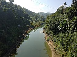
262:The Tlawng River is one of the longest rivers in
726:This article related to a river in India is a
751:
705:
621:Kaladan Multi-Modal Transit Transport Project
393:
219:is situated to the east of the Tlawng river.
8:
368:Mizoram: A Study in Comprehensive Geography
310:Mizoram: A Study in Comprehensive Geography
758:
744:
712:
698:
672:This article related to a location in the
400:
386:
378:
370:. Northern Book Center. pp. Page 38.
284:
299:
307:Pachuau, Rintluanga (1 January 2009).
31:
7:
723:
721:
669:
667:
313:. Northern Book Centre. p. 35.
730:. You can help Knowledge (XXG) by
684:. You can help Knowledge (XXG) by
289:Tlawng river Drinking water source
25:
40:
345:. Cambridge. pp. 149–150.
226:) was proposed for the river.
1:
215:and the Ngashih. The city of
156:185.5 km (115.3 mi)
102:Physical characteristics
366:Pachuau, Rintluanga (2009).
124:1,398 m (4,587 ft)
120: • elevation
144: • location
803:
720:
666:
128:
106:
46:Tlawng, water source for
39:
187: • right
782:Mizoram geography stubs
343:The Camera as a Witness
175: • left
290:
288:
29:River in Assam, India
646: /
161:Basin features
462:Mat River, Mizoram
291:
787:India river stubs
777:Rivers of Mizoram
739:
738:
693:
692:
650:24.867°N 92.600°E
629:
628:
320:978-81-7211-264-6
197:
196:
16:(Redirected from
794:
760:
753:
746:
722:
714:
707:
700:
668:
661:
660:
658:
657:
656:
651:
647:
644:
643:
642:
639:
452:Khawthlangtuipui
402:
395:
388:
379:
372:
371:
363:
357:
356:
338:
332:
331:
329:
327:
304:
222:In 2012, a dam (
188:
176:
121:
44:
32:
21:
802:
801:
797:
796:
795:
793:
792:
791:
767:
766:
765:
764:
719:
718:
664:
654:
652:
648:
645:
640:
637:
635:
633:
632:
630:
625:
609:
578:
557:
536:
415:
406:
376:
375:
365:
364:
360:
353:
340:
339:
335:
325:
323:
321:
306:
305:
301:
296:
260:
232:
186:
174:
145:
119:
54:
30:
23:
22:
15:
12:
11:
5:
800:
798:
790:
789:
784:
779:
769:
768:
763:
762:
755:
748:
740:
737:
736:
717:
716:
709:
702:
694:
691:
690:
655:24.867; 92.600
627:
626:
624:
623:
617:
615:
614:Related topics
611:
610:
608:
607:
602:
597:
592:
586:
584:
580:
579:
577:
576:
571:
565:
563:
559:
558:
556:
555:
550:
544:
542:
538:
537:
535:
534:
529:
524:
519:
514:
509:
504:
499:
494:
489:
484:
479:
474:
469:
464:
459:
454:
449:
444:
439:
434:
429:
423:
421:
417:
416:
407:
405:
404:
397:
390:
382:
374:
373:
358:
351:
341:Pachuau, Joy.
333:
319:
298:
297:
295:
292:
259:
256:
231:
228:
203:is a river of
195:
194:
189:
183:
182:
177:
171:
170:
167:
163:
162:
158:
157:
154:
150:
149:
146:
143:
140:
139:
136:
130:
129:
126:
125:
122:
116:
115:
112:
108:
107:
104:
103:
99:
98:
89:
85:
84:
75:
71:
70:
65:
61:
60:
56:
55:
45:
37:
36:
28:
24:
14:
13:
10:
9:
6:
4:
3:
2:
799:
788:
785:
783:
780:
778:
775:
774:
772:
761:
756:
754:
749:
747:
742:
741:
735:
733:
729:
724:
715:
710:
708:
703:
701:
696:
695:
689:
687:
683:
679:
675:
670:
665:
662:
659:
622:
619:
618:
616:
612:
606:
603:
601:
598:
596:
593:
591:
588:
587:
585:
581:
575:
572:
570:
567:
566:
564:
560:
554:
551:
549:
546:
545:
543:
539:
533:
530:
528:
525:
523:
520:
518:
515:
513:
510:
508:
505:
503:
500:
498:
495:
493:
490:
488:
485:
483:
480:
478:
475:
473:
470:
468:
465:
463:
460:
458:
455:
453:
450:
448:
445:
443:
440:
438:
435:
433:
430:
428:
425:
424:
422:
418:
414:
410:
403:
398:
396:
391:
389:
384:
383:
380:
369:
362:
359:
354:
352:9781107073395
348:
344:
337:
334:
322:
316:
312:
311:
303:
300:
293:
287:
283:
281:
277:
273:
269:
265:
257:
255:
253:
249:
245:
241:
237:
229:
227:
225:
220:
218:
214:
210:
206:
202:
193:
190:
184:
181:
178:
172:
168:
164:
159:
155:
151:
147:
141:
137:
135:
131:
127:
123:
117:
113:
109:
105:
100:
97:
93:
90:
86:
83:
79:
76:
72:
69:
66:
62:
57:
53:
49:
43:
38:
33:
27:
19:
732:expanding it
725:
686:expanding it
671:
663:
631:
367:
361:
342:
336:
324:. Retrieved
309:
302:
261:
233:
221:
200:
198:
35:Tlawng River
26:
18:Tlawng River
653: /
427:Chhimtuipui
409:Hydrography
166:Tributaries
771:Categories
562:Waterfalls
492:Tiau River
442:Karnaphuli
294:References
224:Tlawng Dam
148:Zopui Hill
676:state of
574:Tuirihiau
553:Palak Dil
507:Tuichawng
472:Phairuang
258:Geography
595:Serlui B
569:Vantawng
502:Tuichang
457:Langkaih
326:8 August
59:Location
678:Mizoram
641:92°36′E
638:24°52′N
605:Tuirial
590:Bairabi
548:Tam Dil
522:Tuivawl
517:Tuirini
512:Tuirial
467:Mengpui
437:Kaladan
413:Mizoram
280:Sairang
268:Lunglei
264:Mizoram
252:Silchar
248:Sairang
240:Sairang
236:Silchar
230:History
205:Mizoram
96:Lunglei
78:Mizoram
64:Country
52:Mizoram
674:Indian
600:Tlawng
527:Tuivai
497:Tlawng
482:Teirei
477:Serlui
420:Rivers
349:
317:
276:Teirei
244:Aizawl
217:Aizawl
213:Teirei
201:Tlawng
192:Teirei
169:
153:Length
138:
114:
111:Source
92:Aizawl
88:Cities
48:Aizawl
680:is a
541:Lakes
487:Thega
134:Mouth
82:Assam
74:State
68:India
728:stub
682:stub
583:Dams
347:ISBN
328:2012
315:ISBN
274:and
199:The
532:Tut
447:Kau
411:of
272:Tut
250:to
209:Tut
180:Tut
773::
432:De
282:.
238:.
211:,
94:,
80:,
50:,
759:e
752:t
745:v
734:.
713:e
706:t
699:v
688:.
401:e
394:t
387:v
355:.
330:.
20:)
Text is available under the Creative Commons Attribution-ShareAlike License. Additional terms may apply.