42:
526:
469:
29:
49:
274:
at the start of the 20th century, due to repeated crop failures and conflicts between various communities over water rights. The river also suffered from severe environmental problems with acidic runoff from upstream mining operations. Plans for a series of dams was initiated in 1941 by the
41:
363:
510:
276:
563:
356:
92:
602:
582:
349:
503:
372:
587:
607:
556:
496:
597:
549:
270:
The need for storage reservoirs in the
Kitakami River valley for irrigation purposes was recognized by the
592:
283:. The plan was revived after the war, and the Toyosawa Dam was the third to be constructed (after the
428:
476:
271:
255:
251:
143:
76:
247:
423:
324:
284:
533:
480:
443:
336:
243:
200:
576:
403:
393:
418:
413:
280:
383:
288:
408:
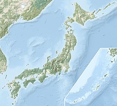
304:
28:
107:
94:
525:
468:
398:
388:
341:
448:
433:
292:
259:
80:
291:). Construction was begun in 1949, and completed in 1961 by the
345:
239:
537:
484:
303:
The
Toyosawa Dam was designed as a solid core concrete
246:
system, located in the southern portion of the city of
209:
199:
191:
183:
178:
170:
162:
154:
149:
139:
131:
123:
86:
72:
64:
21:
231:
225:
557:
504:
357:
8:
532:This Iwate Prefecture location article is a
325:"Toyosawa Dam [Iwate Pref.] - Dams in Japan"
564:
550:
511:
497:
364:
350:
342:
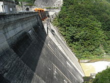
242:on the Toyosawa River, a tributary of the
27:
18:
475:This article about a dam or floodgate in
316:
7:
522:
520:
465:
463:
277:Ministry of Agriculture and Forestry
48:
14:
279:, but all work was halted during
524:
467:
56:Location of ToyosawaDam in Japan
47:
40:
16:Dam in Iwate Prefecture, Japan
1:
536:. You can help Knowledge by
483:. You can help Knowledge by
262:. It was completed in 1961.
232:
624:
519:
462:
379:
307:with a central spillway.
226:
35:
26:
583:Dams in Iwate Prefecture
373:Dams in Iwate Prefecture
603:Tōhoku region dam stubs
124:Construction began
588:Dams completed in 1961
479:of Honshu, Japan is a
108:39.48056°N 140.97444°E
608:Iwate geography stubs
337:photo page with data
201:Catchment area
192:Total capacity
113:39.48056; 140.97444
104: /
293:Kajima Corporation
545:
544:
492:
491:
457:
456:
217:
216:
210:Surface area
150:Dam and spillways
132:Opening date
615:
566:
559:
552:
528:
521:
513:
506:
499:
471:
464:
366:
359:
352:
343:
329:
328:
321:
272:Meiji government
252:Iwate Prefecture
237:
235:
229:
228:
144:Iwate Prefecture
119:
118:
116:
115:
114:
109:
105:
102:
101:
100:
97:
77:Iwate Prefecture
51:
50:
44:
31:
19:
623:
622:
618:
617:
616:
614:
613:
612:
598:Hanamaki, Iwate
573:
572:
571:
570:
518:
517:
460:
458:
453:
375:
370:
333:
332:
323:
322:
318:
313:
301:
268:
223:
112:
110:
106:
103:
98:
95:
93:
91:
90:
60:
59:
58:
57:
54:
53:
52:
17:
12:
11:
5:
621:
619:
611:
610:
605:
600:
595:
590:
585:
575:
574:
569:
568:
561:
554:
546:
543:
542:
529:
516:
515:
508:
501:
493:
490:
489:
472:
455:
454:
452:
451:
446:
444:Wakayanagi Dam
441:
436:
431:
429:Shijūshida Dam
426:
421:
416:
411:
406:
401:
396:
391:
386:
380:
377:
376:
371:
369:
368:
361:
354:
346:
340:
339:
331:
330:
315:
314:
312:
309:
300:
297:
267:
264:
244:Kitakami River
215:
214:
211:
207:
206:
203:
197:
196:
193:
189:
188:
185:
181:
180:
176:
175:
172:
168:
167:
164:
160:
159:
158:Toyosawa River
156:
152:
151:
147:
146:
141:
137:
136:
133:
129:
128:
125:
121:
120:
88:
84:
83:
74:
70:
69:
66:
62:
61:
55:
46:
45:
39:
38:
37:
36:
33:
32:
24:
23:
15:
13:
10:
9:
6:
4:
3:
2:
620:
609:
606:
604:
601:
599:
596:
594:
591:
589:
586:
584:
581:
580:
578:
567:
562:
560:
555:
553:
548:
547:
541:
539:
535:
530:
527:
523:
514:
509:
507:
502:
500:
495:
494:
488:
486:
482:
478:
477:Tōhoku region
473:
470:
466:
461:
450:
447:
445:
442:
440:
437:
435:
432:
430:
427:
425:
422:
420:
417:
415:
412:
410:
407:
405:
404:Ishibuchi Dam
402:
400:
397:
395:
394:Hayachine Dam
392:
390:
387:
385:
382:
381:
378:
374:
367:
362:
360:
355:
353:
348:
347:
344:
338:
335:
334:
326:
320:
317:
310:
308:
306:
298:
296:
294:
290:
286:
282:
278:
273:
265:
263:
261:
257:
256:Tōhoku region
253:
249:
245:
241:
234:
233:Toyosawa damu
222:
212:
208:
204:
202:
198:
195:23,356,000 m3
194:
190:
187:Toyosawa Lake
186:
182:
177:
173:
169:
165:
161:
157:
153:
148:
145:
142:
138:
134:
130:
126:
122:
117:
89:
85:
82:
78:
75:
71:
67:
65:Official name
63:
43:
34:
30:
25:
20:
593:Gravity dams
538:expanding it
531:
485:expanding it
474:
459:
439:Toyosawa Dam
438:
424:Sannōkai Dam
419:Kuzumaru Dam
414:Ishibane Dam
319:
302:
285:Sannōkai Dam
281:World War II
269:
258:of northern
221:Toyosawa Dam
220:
218:
213:136 hectares
174:150.0 meters
409:Irihata Dam
305:gravity dam
166:59.1 meters
140:Operator(s)
111: /
99:140°58′28″E
87:Coordinates
22:ToyosawaDam
577:Categories
311:References
96:39°28′50″N
399:Isawa Dam
389:Gosho Dam
384:Gandō Dam
289:Gandō Dam
179:Reservoir
449:Yuda Dam
434:Tase Dam
287:and the
248:Hanamaki
155:Impounds
73:Location
266:History
254:in the
184:Creates
299:Design
205:60 km2
171:Length
163:Height
260:Japan
238:is a
81:Japan
534:stub
481:stub
227:豊沢ダム
219:The
135:1961
127:1949
68:豊沢ダム
240:dam
579::
295:.
250:,
230:,
79:,
565:e
558:t
551:v
540:.
512:e
505:t
498:v
487:.
365:e
358:t
351:v
327:.
236:)
224:(
Text is available under the Creative Commons Attribution-ShareAlike License. Additional terms may apply.