117:
110:
34:
202:
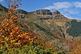
The summit's name references its three-headed shape composed by rocky outcrops. Trite Chuki's northeast slopes are very steep and almost vertical. The valleys of the
Androvitsa and Grafska rivers originate east of Trite Chuki; the latter feeds the Lanzhin Skok, Voden Skok and Durshin Skok waterfalls.
324:
314:
66:
329:
109:
319:
292:
255:
218:
59:
195:, on the border ridge between Bulgaria and Serbia. Trite Chuki is 1,935 m (6,348 ft) high and belongs to the
172:
288:
251:
192:
184:
160:
222:
153:
308:
211:
207:
206:
The middle outcrop hosts the remains of a basic fortification, reportedly built by
196:
81:
68:
226:
142:
33:
146:
49:
203:
The large
Chiprovtsi Waterfall originates to the north of the peak.
199:
Mountain, one of the highest parts of the Balkan
Mountains.
217:
The most common trailheads for ascending Trite Chuki are
38:
View from the trail coming from
Kopilovtsi, Bulgaria
152:
138:
97:
58:
48:
43:
21:
269:
267:
116:
8:
18:
238:
287:(in Bulgarian). Ойларипи. p. 45.
250:(in Bulgarian). Домино. p. 262.
7:
191:) is a rocky summit in the western
14:
325:International mountains of Europe
315:Mountains of the Balkan mountains
115:
108:
32:
285:Връшка чука – Ком – пътеводител
221:and Chiprovtsi in Bulgaria and
16:Mountain in Bulgaria and Serbia
1:
330:Landforms of Montana Province
54:1,935 m (6,348 ft)
179:, "the three outcrops") or
346:
246:Цветанов, Момчил (2014).
188:
176:
102:
82:43.3323873°N 22.6565825°E
31:
26:
320:Bulgaria–Serbia border
283:Момчев, Живко (2017).
123:Trite Chuki / Tri Čuke
87:43.3323873; 22.6565825
22:Trite Chuki / Tri Čuke
27:Трите чуки / Три Чуке
129:Location in Bulgaria
248:Българските планини
78: /
44:Highest point
166:
165:
337:
299:
298:
280:
274:
273:Цветанов, p. 275
271:
262:
261:
243:
214:in August 1863.
193:Balkan Mountains
190:
178:
161:Balkan Mountains
156:
119:
118:
112:
93:
92:
90:
89:
88:
83:
79:
76:
75:
74:
71:
36:
19:
345:
344:
340:
339:
338:
336:
335:
334:
305:
304:
303:
302:
295:
282:
281:
277:
272:
265:
258:
245:
244:
240:
235:
154:
134:
133:
132:
131:
130:
127:
126:
125:
124:
120:
86:
84:
80:
77:
72:
69:
67:
65:
64:
39:
17:
12:
11:
5:
343:
341:
333:
332:
327:
322:
317:
307:
306:
301:
300:
293:
275:
263:
256:
237:
236:
234:
231:
164:
163:
158:
150:
149:
140:
136:
135:
128:
122:
121:
114:
113:
107:
106:
105:
104:
103:
100:
99:
95:
94:
62:
56:
55:
52:
46:
45:
41:
40:
37:
29:
28:
24:
23:
15:
13:
10:
9:
6:
4:
3:
2:
342:
331:
328:
326:
323:
321:
318:
316:
313:
312:
310:
296:
294:9786199041581
290:
286:
279:
276:
270:
268:
264:
259:
257:9789546512499
253:
249:
242:
239:
232:
230:
228:
224:
220:
215:
213:
212:Panayot Hitov
209:
208:Angel Voyvoda
204:
200:
198:
194:
186:
182:
174:
170:
162:
159:
157:
151:
148:
144:
141:
137:
111:
101:
96:
91:
63:
61:
57:
53:
51:
47:
42:
35:
30:
25:
20:
284:
278:
247:
241:
216:
205:
201:
180:
168:
167:
155:Parent range
229:in Serbia.
169:Trite Chuki
85: /
60:Coordinates
309:Categories
233:References
219:Kopilovtsi
197:Chiprovtsi
177:Трите чуки
73:22°39′24″E
70:43°19′57″N
173:Bulgarian
98:Geography
50:Elevation
227:Dojkinci
223:Topli Do
189:Три Чуке
181:Tri Čuke
143:Bulgaria
185:Serbian
139:Country
291:
254:
147:Serbia
289:ISBN
252:ISBN
225:and
210:and
311::
266:^
187::
175::
145:,
297:.
260:.
183:(
171:(
Text is available under the Creative Commons Attribution-ShareAlike License. Additional terms may apply.