102:
95:
26:
279:
325:
The climate of the Trnovo Forest
Plateau is defined by its elevation and orientation. The Trnovo Forest Plateau lies in a continental temperature zone. It receives an average of 1,881 millimeters (74.1 in) of precipitation per year. Differences in the quantity of precipitation differ little on a
427:
In addition to forestry, farming is also an important economic activity. The basic farming activity is animal husbandry, especially raising cattle. The share of the farming population is 14.4%. Tourism is becoming increasingly important: the steep slopes of the plateau attract hikers, and some karst
229:
the rivers leveled the tectonic upwelling and filled the valleys. Traces were also left by
Pliocene glaciation because glaciers created small cirques on what had been a relatively level surface, as well as ground moraines and terminal moraines. The rivers transported gravel and deposited it in lower
418:
The plateau had a population of 4,534 in the 1991 census, and the population density was only 9 per square kilometer (23/sq mi), making the area one of the most sparsely populated in
Slovenia. Only the western part is inhabited. The settlements were formed through more recent high-elevation
381:
The share of forest is 75.5%, but this is increasing because of the afforestation of abandoned farmland. Poor accessibility has resulted in relatively good preservation of the landscape features. The highest peaks are overgrown with mountain pine or grass. Dinaric beech and fir forest grow at
172:. The Trnovo Forest Plateau has a karst character, without surface watercourses and broken up by closed valleys, outcroppings, hills, caves, shafts, and smaller karst features: solution pans, rills, karrens, and other features. Significant karst features include
330:
is a typical weather phenomenon, blowing down from the plateau towards the sea with gusts often exceeding 100 kilometers per hour (62 mph). The bora can cause considerable damage in the area, uprooting trees and tearing the roofs off of houses.
326:
monthly basis. The greatest precipitation is in
November (293 millimeters or 11.5 inches) and the least in February (135 millimeters or 5.3 inches). The majority of winter precipitation is in the form of snow, especially at higher elevations. The
262:, 1,480 meters or 4,860 feet), Mount Poldanovec (1,298 meters or 4,259 feet), and Pointed Peak (Špičasti vrh 1,128 meters or 3,701 feet), and on the southern side Big Mount Modrasovec (
382:
elevations between 700 meters (2,300 ft) and 1,200 meters (3,900 ft). At lower elevations this transitions into
Dinaric submontane beech forest. There is relatively little
225:
The influence of tectonic activity is very evident in the area. There are many depressions, solution valleys, small karst poljes, and the remains of former river valleys. During the
238:
The north side of the plateau shows tectonic formation along the Idrija Fault oriented in the
Dinaric direction, and the south side shows the results of tectonic thrusting of
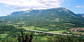
339:
Despite the abundant precipitation, karst plateaus have almost no water. The drainage divide is unclear because of the karst surface. The largest spring is that of the
51:
548:
359:). The highest vegetation is on Little Mount Golak (1,495 meters or 4,905 feet), which is bare at the summit, below which grow dwarf willow (
543:
410:
is very uneven. The substantial precipitation quickly erodes the soil, and it is also carried away by the bora wind in exposed locations.
538:
489:
Odlok o spremembah in dopolnitvah prostorskih sestavin dolgoročnega in družbenega plana Občine Ajdovščina za območje Občine Ajdovščina.
94:
419:
colonization, and the dominant patterns are clustered villages and isolated farms. The age profile of the population is unfavorable.
523:
246:
flysch. Two-thirds of the surface is covered by limestone, one-fourth by dolomite, and the remainder is flysch and loose material.
402:
have developed on
Cretaceous and Jurassic limestone and on Triassic dolomite. More acidic soils are found only on limestone with
258:, 1,495 meters or 4,905 feet). On the northern side, some other panoramic and frequently visited summits are Little Mount Golak (
44:
428:
features also attract visitors, especially ice caves and sinkholes because of the vegetation associated with them.
184:) in the eastern part of the plateau, measuring 385 meters (1,263 ft) by 1,550 meters (5,090 ft), is a
288:
340:
199:
177:
154:
31:
344:
295:
188:
and in the past ice was harvested from it and exported via
Gorizia and Trieste to Egypt.
134:
532:
266:, 1,355 meters or 4,446 feet), Mount Kucelj (1,237 meters or 4,058 feet), Blue Peak (
169:
141:
374:). Protected flora grows in the rocky crevices, including the Carniolan primrose (
25:
327:
488:
367:
316:
Paradana Cave (a deep cave, with ice that was harvested and sold in the past)
66:
53:
383:
310:
407:
399:
395:
270:, 1,002 meters or 3,287 feet), and Kovk Hill (962 meters or 3,156 feet).
239:
226:
214:
173:
127:
165:
243:
355:
The Trnovo Forest
Plateau is covered by mixed beech and fir forest (
508:
Nepopolno raztapljanje karbonatnih kamnin v kraških jamah
Slovenije
403:
361:
313:(a Vauclusian spring and small lake with a deep unexplored siphon)
278:
277:
162:
198:
Golak Peaks (1,495 meters or 4,905 feet) and Spruce Valley (
191:
The Trnovo Forest Plateau has three nature reserves:
176:. The vegetation inversion at Big Paradana Ice Cave (
213:The southern ridge of the Trnovo Forest Plateau is
133:
123:
82:
43:
38:
18:
168:that constitutes the extreme northwest end of the
462:Perko, Drago, & Milan Orožen Adamič. 1998.
446:Na prelomnici: razvojna vprašanja Občine Idrija
479:, vol. 6, p. 115. Ljubljana: Mladinska knjiga.
101:
8:
491:Official Gazette of the Republic of Slovenia
458:
456:
454:
15:
444:Nered, Janez, & Drago Perko. 2010.
437:
254:The highest summit is Big Mount Golak (
466:. Ljubljana: Mladinska knjiga, p. 324.
406:. Due to karstification, the depth of
301:Hubelj karst spring (above Ajdovščina)
475:Habič, Peter. 1992. Ledena jama. In:
114:Location of the Trnovo Forest Plateau
7:
242:limestone and dolomite over younger
30:The Trnovo Forest Plateau seen from
294:Otlica natural rock window (above
287:Skozno natural rock window (above
14:
524:Trnovo Forest Plateau on Geopedia
549:Plateaus in the Slovene Littoral
448:. Ljubljana: Založba ZRC, p. 51.
230:areas, filling the depressions.
100:
93:
24:
464:Slovenija: pokrajine in ljudje
1:
182:Velika ledena jama v Paradani
304:Vipava springs (near Vipava)
544:Landscape parks in Slovenia
565:
539:Karst plateaus of Slovenia
506:Zupan Hajna, Nadja. 2014.
209:The Smrečje forest reserve
510:. Ljubljana: ZRC, p. 165.
87:
23:
357:Abieti-fagetum dinaricum
477:Enciklopedija Slovenije
283:
203:
181:
158:
281:
206:, a karst depression)
195:Big Paradana Ice Cave
151:Trnovo Forest Plateau
108:Trnovo Forest Plateau
67:45.96278°N 13.87222°E
19:Trnovo Forest Plateau
63: /
376:Primula carniolica
307:Lijak karst spring
284:
282:Skozno rock window
72:45.96278; 13.87222
39:Highest point
493:, 30 August 2004.
274:Natural landmarks
264:Veliki Modrasovec
147:
146:
556:
511:
504:
498:
497:
486:
480:
473:
467:
460:
449:
442:
137:
104:
103:
97:
78:
77:
75:
74:
73:
68:
64:
61:
60:
59:
56:
28:
16:
564:
563:
559:
558:
557:
555:
554:
553:
529:
528:
520:
515:
514:
505:
501:
495:
487:
483:
474:
470:
461:
452:
443:
439:
434:
425:
416:
392:
353:
337:
323:
276:
252:
236:
223:
186:locus classicus
135:
119:
118:
117:
116:
115:
112:
111:
110:
109:
105:
71:
69:
65:
62:
57:
54:
52:
50:
49:
34:
12:
11:
5:
562:
560:
552:
551:
546:
541:
531:
530:
527:
526:
519:
518:External links
516:
513:
512:
499:
481:
468:
450:
436:
435:
433:
430:
424:
421:
415:
412:
391:
388:
352:
349:
336:
333:
322:
319:
318:
317:
314:
308:
305:
302:
299:
292:
275:
272:
251:
248:
235:
232:
222:
219:
211:
210:
207:
204:Smrekova draga
196:
145:
144:
139:
131:
130:
125:
121:
120:
113:
107:
106:
99:
98:
92:
91:
90:
89:
88:
85:
84:
80:
79:
47:
41:
40:
36:
35:
29:
21:
20:
13:
10:
9:
6:
4:
3:
2:
561:
550:
547:
545:
542:
540:
537:
536:
534:
525:
522:
521:
517:
509:
503:
500:
494:
492:
485:
482:
478:
472:
469:
465:
459:
457:
455:
451:
447:
441:
438:
431:
429:
422:
420:
413:
411:
409:
405:
401:
397:
389:
387:
385:
379:
377:
373:
369:
368:mountain pine
365:
363:
358:
350:
348:
346:
342:
334:
332:
329:
320:
315:
312:
309:
306:
303:
300:
297:
293:
290:
286:
285:
280:
273:
271:
269:
265:
261:
257:
249:
247:
245:
241:
233:
231:
228:
220:
218:
216:
208:
205:
201:
197:
194:
193:
192:
189:
187:
183:
179:
175:
171:
167:
164:
160:
159:Trnovski gozd
156:
152:
143:
140:
138:
132:
129:
126:
122:
96:
86:
81:
76:
48:
46:
42:
37:
33:
32:Vipavski Križ
27:
22:
17:
507:
502:
496:(in Slovene)
490:
484:
476:
471:
463:
445:
440:
426:
417:
393:
380:
375:
371:
360:
356:
354:
341:Hubelj River
338:
324:
267:
263:
259:
256:Veliki Golak
255:
253:
237:
224:
212:
190:
185:
170:Dinaric Alps
150:
148:
142:Dinaric Alps
136:Parent range
70: /
45:Coordinates
533:Categories
432:References
414:Population
372:Pinus mugo
351:Vegetation
345:Ajdovščina
296:Ajdovščina
260:Mali Golak
58:13°52′20″E
55:45°57′46″N
384:shrubland
328:bora wind
311:Wild Lake
268:Sinji vrh
250:Mountains
174:ice caves
83:Geography
408:regolith
400:rendzina
396:cambisol
394:Chromic
240:Mesozoic
227:Pliocene
128:Slovenia
124:Location
423:Economy
321:Climate
221:Terrain
200:Slovene
178:Slovene
166:plateau
161:) is a
155:Slovene
366:) and
289:Šmihel
244:Eocene
404:chert
362:Salix
343:near
335:Water
215:Čaven
163:karst
398:and
390:Soil
234:Rock
149:The
378:).
364:sp.
535::
453:^
386:.
347:.
217:.
202::
180::
157::
370:(
298:)
291:)
153:(
Text is available under the Creative Commons Attribution-ShareAlike License. Additional terms may apply.