317:
34:
50:
328:. In 1230 it was granted to Wizo the Fleming. It was extensively rebuilt in 1870-73 and renovated in 1991–92. It was further restored in 1999 by Hereford architect Lingen Barker. It became a Grade II listed building on 16 July 2004. There is a house on the edge of Uzmaston along the lane from Boulston named "The Cottage". There are the ruins of a cottage between the main lane (known locally as "Nans Lane") and the Cleddau, just to the southwest of the village.
57:
347:, stated that Uzmaston "comprises a moderate extent of enclosed and cultivated land: the soil is generally fertile, and the inhabitants are chiefly employed in agriculture. The western part of it, containing the straggling extemity of a suburb of Haverfordwest, called Cartlett, is included within the new electoral limits of that borough.
159:
331:
The village is the start of the frolic, a public footpath that starts at the church gates, through the churchyard, across the field and then follows the River
Cleddau into Haverfordwest. From the churchyard looking down river is white rock, a single chalk rock on the edge of the river.
305:. Its name is a compound word meaning "Osmund's farm". In 1993, five Roman coins were unearthed behind the church at Uzmaston. At the time of the 1851 census, Uzmaston belonged to a parish comprising an area of 2,070 acres with a population of 683 people, 307 male and 376 female.
534:
421:
183:
88:
176:
674:
566:
510:
484:
457:
49:
171:
316:
721:
293:
St. Ismael's Parish Church which has existed since at least 1230, was extensively rebuilt in 1870-73, and restored in the 1990s.
207:
217:
131:
582:
282:
225:
81:
33:
113:
97:
340:
145:
556:
402:
212:
188:
164:
648:
632:
684:
664:
500:
474:
670:
562:
506:
480:
453:
278:
696:
290:
502:
The
Religious Census of 1851, a Calendar of the Returns Relating to Wales: South Wales
715:
286:
270:
266:
121:
70:
426:
371:
350:
Geologically, the area is known for the yellow-grey
Uzmaston Beds, dated to the
324:
Its parish church is dedicated to the 6th-century Breton prince and Welsh saint
301:
Historically, Uzmaston and the surrounding parish belonged to the
Hundred of
240:
227:
302:
607:
308:
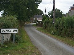
Originally a farming village, the dwellings sit nestled between two farms.
526:
505:. General Register Office, University of Wales Press. 1976. p. 425.
351:
274:
325:
262:
653:. Centre national de la recherche scientifique. 1956. p. 248.
315:
137:
354:
period, which are unfossiliferous in the lower parts.
182:
170:
158:
144:
130:
112:
96:
80:
26:
269:, Wales, about 1 mile (1.6 km) south-east of
473:Peter Guest; Nicholas Wells; Nick Wells (2007).
637:. Geologist's Association. 1972. p. 151.
8:
23:
16:Village and parish in Pembrokeshire, Wales
527:"St Ismael's Church, Uzmaston (414797)"
396:
394:
392:
363:
153:
129:
95:
79:
30:
692:
682:
555:Thornhill Timmins, H. (4 April 2018).
181:
169:
157:
143:
111:
7:
416:
414:
476:Iron age and Roman coins from Wales
452:. Oxford: Oxford University Press.
450:A Dictionary of British Place-Names
404:A Topographical Dictionary of Wales
345:A Topographical Dictionary of Wales
273:. The village, to the northwest of
558:Nooks and Corners of Pembrokeshire
14:
285:, and lies near the bank of the
56:
55:
48:
32:
666:Special Papers, Issues 152-156
608:"Ruined cottage near Uzmaston"
283:Uzmaston, Boulston and Slebech
105:Uzmaston, Boulston and Slebech
1:
669:. Society. 1974. p. 70.
289:. It contains the Grade II-
82:OS grid reference
738:
722:Villages in Pembrokeshire
198:
194:
154:
43:
31:
21:Human settlement in Wales
587:British Listed Buildings
583:"Church of Saint Ismael"
401:Lewis, Samuel (1840).
321:
448:Mills, A. D. (2003).
319:
561:. BOD. p. 185.
277:, forms part of the
146:Sovereign state
320:St. Ismael's Church
237: /
114:Principal area
322:
177:Mid and West Wales
676:978-0-8137-2152-1
568:978-3-7326-3189-6
512:978-0-7083-0619-2
486:978-90-77297-34-6
459:978-0-19-852758-9
343:, writing in his
256:
255:
729:
701:
700:
694:
690:
688:
680:
661:
655:
654:
645:
639:
638:
629:
623:
622:
620:
618:
604:
598:
597:
595:
593:
579:
573:
572:
552:
546:
545:
543:
541:
523:
517:
516:
497:
491:
490:
470:
464:
463:
445:
439:
438:
436:
434:
418:
409:
408:
398:
387:
386:
384:
382:
368:
252:
251:
249:
248:
247:
242:
238:
235:
234:
233:
230:
204:
140:
92:
91:
69:Location within
59:
58:
52:
36:
24:
737:
736:
732:
731:
730:
728:
727:
726:
712:
711:
710:
705:
704:
691:
681:
677:
663:
662:
658:
647:
646:
642:
631:
630:
626:
616:
614:
606:
605:
601:
591:
589:
581:
580:
576:
569:
554:
553:
549:
539:
537:
525:
524:
520:
513:
499:
498:
494:
487:
472:
471:
467:
460:
447:
446:
442:
432:
430:
420:
419:
412:
400:
399:
390:
380:
378:
370:
369:
365:
360:
338:
314:
299:
287:Western Cleddau
245:
243:
239:
236:
231:
228:
226:
224:
223:
222:
202:
136:
126:
108:
87:
86:
76:
75:
74:
73:
67:
66:
65:
64:
60:
39:
22:
17:
12:
11:
5:
735:
733:
725:
724:
714:
713:
709:
708:External links
706:
703:
702:
693:|website=
675:
656:
640:
624:
599:
574:
567:
547:
518:
511:
492:
485:
465:
458:
440:
410:
407:. p. 480.
388:
362:
361:
359:
356:
337:
334:
313:
310:
298:
295:
254:
253:
241:51.79°N 4.95°W
221:
220:
215:
210:
205:
203:List of places
199:
196:
195:
192:
191:
186:
180:
179:
174:
168:
167:
162:
156:
155:
152:
151:
150:United Kingdom
148:
142:
141:
134:
128:
127:
125:
124:
118:
116:
110:
109:
107:
106:
102:
100:
94:
93:
84:
78:
77:
68:
62:
61:
54:
53:
47:
46:
45:
44:
41:
40:
37:
29:
28:
20:
15:
13:
10:
9:
6:
4:
3:
2:
734:
723:
720:
719:
717:
707:
698:
686:
678:
672:
668:
667:
660:
657:
652:
651:
644:
641:
636:
635:
628:
625:
613:
609:
603:
600:
588:
584:
578:
575:
570:
564:
560:
559:
551:
548:
536:
532:
528:
522:
519:
514:
508:
504:
503:
496:
493:
488:
482:
478:
477:
469:
466:
461:
455:
451:
444:
441:
429:
428:
423:
417:
415:
411:
406:
405:
397:
395:
393:
389:
377:
376:Genuki.org.uk
373:
367:
364:
357:
355:
353:
348:
346:
342:
335:
333:
329:
327:
318:
311:
309:
306:
304:
296:
294:
292:
288:
284:
280:
276:
272:
271:Haverfordwest
268:
267:Pembrokeshire
264:
260:
250:
219:
218:Pembrokeshire
216:
214:
211:
209:
206:
201:
200:
197:
193:
190:
187:
185:
178:
175:
173:
166:
163:
161:
149:
147:
139:
135:
133:
123:
122:Pembrokeshire
120:
119:
117:
115:
104:
103:
101:
99:
90:
85:
83:
72:
71:Pembrokeshire
51:
42:
35:
25:
19:
665:
659:
649:
643:
633:
627:
615:. Retrieved
611:
602:
590:. Retrieved
586:
577:
557:
550:
540:29 September
538:. Retrieved
530:
521:
501:
495:
475:
468:
449:
443:
431:. Retrieved
425:
403:
379:. Retrieved
375:
366:
349:
344:
341:Samuel Lewis
339:
330:
323:
307:
300:
258:
257:
246:51.79; -4.95
18:
634:Proceedings
617:3 September
592:3 September
433:3 September
427:Google Maps
381:16 February
261:is a small
244: /
165:Dyfed-Powys
479:. Moneta.
422:"Uzmaston"
372:"Uzmaston"
358:References
695:ignored (
685:cite book
312:Landmarks
303:Dungleddy
279:community
184:Ambulance
98:Community
716:Category
612:Geograph
352:Silurian
275:Boulston
259:Uzmaston
89:SM969144
63:Uzmaston
38:Uzmaston
27:Uzmaston
531:Coflein
424:(Map).
297:History
229:51°47′N
132:Country
673:
650:Europe
565:
535:RCAHMW
509:
483:
456:
326:Isfael
291:listed
263:parish
232:4°57′W
160:Police
213:Wales
189:Welsh
138:Wales
697:help
671:ISBN
619:2019
594:2019
563:ISBN
542:2021
507:ISBN
481:ISBN
454:ISBN
435:2019
383:2016
336:Land
172:Fire
281:of
265:in
718::
689::
687:}}
683:{{
610:.
585:.
533:.
529:.
413:^
391:^
374:.
208:UK
699:)
679:.
621:.
596:.
571:.
544:.
515:.
489:.
462:.
437:.
385:.
Text is available under the Creative Commons Attribution-ShareAlike License. Additional terms may apply.