69:
174:
17:
96:. After 1826 the British administered the newly acquired regions via two commissioners: the Senior Commissioner who administered the "North-East of Rangpur" (largely the undivided Goalpara) in addition to the newly acquired region between Manas river and Biswanath; and the Junior Commissioner, who administered the region to the east of Biswanath. In March 1833 the British established district administration in the region west of the
160:
416:(Kamarupa) was reorganized as a new state, 'Kamata' by name with Kamatapur as capital. The exact time when the change was made is uncertain. But possibly it had been made by Sandhya (c. 1250 – 1270) as a safeguard against mounting dangers from the east and the west. Its control on the eastern regions beyond the Manah (Manas river) was lax."(
112:
in the south. Each district were to be administered by a
Principal Assistant, deputed by a Junior Assistant. But due to a paucity of funds, the six pargana region had only a Junior Assistant, and by 1836, the Kamrup district acquired its "undivided" form and name.
298:
In this war which was fought not only in Assam but also in Burma, the
Burmese were ultimately defeated and had to make peace with the British by the treaty of Yandabo (1826) by which the Burmese withdrew from
208:; but its control of the region that later came to be Undivided Kamrup district was lax. This region thus stopped being a political center till the capital of Assam was moved in the 20th century from
68:
192:
dynasties. After the breakup of the
Kamarupa kingdom, the region faced several invasions by the rulers of Bengal. Soon after the invasion of
541:
423:
371:
351:
331:
536:
507:
130:
36:
197:
193:
230:
225:
121:
The district retained its colonial administrative structure post
Independence of India in 1947. In 1983
32:
250:
100:, with the Kamrup district originally envisaged as two separate districts among 3 others: the six
85:
72:
James
Rennell's 1776 map shows the eastern boundary of the British controlled regions before 1824
173:
503:
188:, the headquarters of Undivided Kamrup district, was the political center of two of the three
16:
126:
122:
81:
76:
The administrative district of Kamrup was first constituted from the western portion of the
44:
40:
165:
138:
52:
133:
was formed to cover the urban core of the district, and 1 June 2004 saw the formation of
274:
205:
134:
97:
48:
177:
A major portion of undivided Kamrup region was under the
Kingdom of Bhutan before the
530:
442:
Bannerje, A C (1992). "Chapter 1: The New Regime, 1826-31". In
Barpujari, H K (ed.).
154:
93:
28:
201:
141:
districts. The headquarters of both Kamrup
Metropolitan and Kamrup districts is at
77:
497:
470:
89:
104:
largely co-terminus with present-day
Barpeta and Nagarberra; and the twenty
296:
The Indian
Encyclopaedia: Biographical, Historical, Religious ..., Volume 1
209:
189:
185:
178:
142:
51:(2004) districts were formed. It was announced in January 2020 that the
159:
55:
sub-division of Barpeta district will be upgraded to a full district.
213:
137:
which was formed from parts of three districts—Barpeta, Nalbari and
393:
129:
was then similarly split off on 14 August 1985. On 3 February 2003
446:. Vol. IV. Guwahati: Publication Board, Assam. pp. 1–43.
269:
267:
158:
67:
15:
88:
of 1826. The western boundary of this district was the
455:. Munshiram Manoharlal Publishers Pvt Ltd, New Delhi.
92:, and the eastern boundary of this district was the
444:The Comprehensive History of Assam: Modern Period
307:
305:
27:is a former administrative district located in
370:harv error: no target: CITEREFBannerjee1992 (
350:harv error: no target: CITEREFBannerjee1992 (
330:harv error: no target: CITEREFBannerjee1992 (
8:
251:"Five years of Kamrup district bifurcation"
422:harv error: no target: CITEREFSarkar1992 (
387:
385:
383:
381:
502:. Cambridge: Cambridge University Press.
365:
345:
325:
200:, a Kamarupa ruler, moved his capital to
464:. New Delhi: Concept Publishing Company.
172:
84:that the British acquired following the
242:
489:History of the Koch Kingdom: 1515-1615
417:
312:
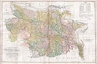
20:The Undivided Kamrup district in 1931
7:
275:"Welcome to Kamrup Metro District"
14:
462:Agrarian System of Medieval Assam
475:. Vol. 1. Trübner & co
469:Hunter, William Wislon (1879).
164:Ancient scriptures often refer
472:A Statistical Account of Assam
1:
491:. Delhi: Mittal Publications.
542:History of the Kamrup region
131:Kamrup Metropolitan district
392:Law, Gwillim (2011-09-25).
558:
496:Richards, John F. (1995).
453:Last Days of Ahom Monarchy
194:Malik Ikhtiyaruddin Iuzbak
152:
537:Former districts of Assam
25:Undivided Kamrup district
460:Gogoi, Jahnavi (2002).
226:Kamrup (disambiguation)
125:was split from Kamrup.
451:Baruah, S. L. (1993).
294:Subodh Kapoor - 2002,
182:
170:
73:
21:
176:
162:
153:Further information:
108:in the north and six
71:
19:
394:"Districts of India"
204:and established the
37:Kamrup Metropolitan
253:. assamtribune.com
183:
171:
168:as heart of Kamrup
86:Treaty of Yandaboo
74:
22:
499:The Mughal Empire
420:, pp. 40–41)
368:, pp. 53–54)
117:Post-Independence
549:
520:
518:
516:
492:
487:Nath, D (1989).
483:
481:
480:
465:
456:
447:
428:
427:
414:
408:
407:
405:
404:
389:
376:
375:
362:
356:
355:
342:
336:
335:
322:
316:
309:
300:
292:
286:
285:
283:
282:
277:. indianngos.com
271:
262:
261:
259:
258:
247:
127:Nalbari district
123:Barpeta district
64:Pre-Independence
557:
556:
552:
551:
550:
548:
547:
546:
527:
526:
523:
514:
512:
510:
495:
486:
478:
476:
468:
459:
450:
441:
437:
432:
431:
421:
415:
411:
402:
400:
391:
390:
379:
369:
363:
359:
349:
343:
339:
329:
328:, pp. 7–8)
323:
319:
310:
303:
293:
289:
280:
278:
273:
272:
265:
256:
254:
249:
248:
244:
239:
222:
169:
166:Kamakhya temple
157:
151:
119:
80:then under the
66:
61:
12:
11:
5:
555:
553:
545:
544:
539:
529:
528:
522:
521:
508:
493:
484:
466:
457:
448:
438:
436:
433:
430:
429:
409:
377:
366:Bannerjee 1992
357:
346:Bannerjee 1992
337:
326:Bannerjee 1992
317:
301:
287:
263:
241:
240:
238:
235:
234:
233:
228:
221:
218:
206:Kamata kingdom
163:
150:
147:
135:Baksa district
118:
115:
98:Dhansiri river
82:Burmese Empire
65:
62:
60:
57:
13:
10:
9:
6:
4:
3:
2:
554:
543:
540:
538:
535:
534:
532:
525:
511:
505:
501:
500:
494:
490:
485:
474:
473:
467:
463:
458:
454:
449:
445:
440:
439:
434:
425:
419:
413:
410:
399:
395:
388:
386:
384:
382:
378:
373:
367:
361:
358:
353:
348:, p. 53)
347:
341:
338:
333:
327:
321:
318:
315:, p. 17)
314:
308:
306:
302:
297:
291:
288:
276:
270:
268:
264:
252:
246:
243:
236:
232:
229:
227:
224:
223:
219:
217:
215:
211:
207:
203:
199:
195:
191:
187:
180:
175:
167:
161:
156:
155:Kamrup region
148:
146:
144:
140:
136:
132:
128:
124:
116:
114:
111:
107:
103:
99:
95:
94:Barnadi river
91:
87:
83:
79:
70:
63:
59:Establishment
58:
56:
54:
50:
46:
42:
38:
34:
30:
29:Western Assam
26:
18:
524:
513:. Retrieved
498:
488:
477:. Retrieved
471:
461:
452:
443:
412:
401:. Retrieved
397:
360:
340:
320:
295:
290:
279:. Retrieved
255:. Retrieved
245:
202:North Bengal
196:in 1257 CE,
184:
120:
109:
105:
101:
78:Ahom kingdom
75:
33:Kamrup Rural
24:
23:
515:January 26,
418:Sarkar 1992
313:Hunter 1879
90:Manas river
47:(1985) and
31:from which
531:Categories
509:0521566037
479:2012-12-13
435:References
403:2011-10-11
281:2013-01-24
257:2013-01-24
398:Statoids
220:See also
210:Shillong
190:Kamarupa
186:Guwahati
179:Duar War
143:Guwahati
106:parganas
102:parganas
43:(1983),
39:(2003),
35:(2003),
231:Kamrupi
198:Sandhya
181:of 1865
149:History
45:Nalbari
41:Barpeta
506:
299:Assam.
214:Dispur
139:Kamrup
53:Bajali
237:Notes
110:duars
49:Baksa
517:2013
504:ISBN
424:help
372:help
352:help
332:help
212:to
533::
396:.
380:^
304:^
266:^
216:.
145:.
519:.
482:.
426:)
406:.
374:)
364:(
354:)
344:(
334:)
324:(
311:(
284:.
260:.
Text is available under the Creative Commons Attribution-ShareAlike License. Additional terms may apply.