58:
31:
47:
326:, following what was the shoreline past where the UW power plant and University Village are today. A longhouse was near the present UW power plant (across Montlake Boulevard from the IMA building), others were around the north shores which were about mile farther north than today, and shores east of what is now the
617:
145:. The island, and the wetlands in which it sits on the lake's shore, were "the result of conversion of shallow water lake habitats following lake level lowering." The island's soil is mostly
93:
828:
267:, "a tiny hole drilled to measure the thickness of a canoe"), for the narrow passage through then-large and resource-rich Union Bay marsh. Traces of the marsh survive as the
157:
When the level of Lake
Washington was dropped nearly nine feet (2.7 m) in 1916 as a result of the opening of the Ship Canal, a good portion of Union Bay and Union Bay
295:
for tens of people) may have been used as a potlatch house. The
Duwamish Tribe is today leveraging the sacred site in the path of substantial enlargement of
886:
319:
182:
795:
51:
837:
653:
231:
644:
881:
809:
454:
668:
284:
637:
677:. Seattle City Clerk's Neighborhood Map Atlas (n.d., map.jpg c. 17 June 2002), retrieved 21 April 2006. Note caveat in footer.
330:, with a longhouse or two between what is now the Center for Urban Horticulture and Children's Hospital. Villages were diffuse.
39:
876:
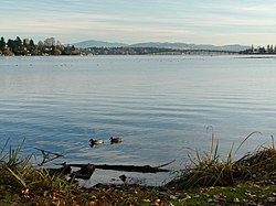
633:
412:
315:
216:
208:
585:
Dailey referenced "Puget Sound
Geography" by T. T. Waterman. Washington DC: National Anthropological Archives, mss. ;
812:. Seattle City Clerk's Neighborhood Map Atlas (n.d., map.jpg 13 June), retrieved 21 April 2006. Note caveat in footer.
296:
288:
142:
127:
107:
97:
336:
or Lake John and his family were among the memorable residents around Union Bay in the early decades of
Seattle.
304:
272:
111:
822:
713:
626:
189:
103:
327:
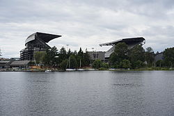
268:
197:
174:
35:
526:
Higman, Harry
Wentworth. Union Bay, the life city". Seattle, University of Washington Press, 1951. Print.
629:
Department of Earth and Space
Sciences – via King County Department of Natural Resources and Parks
220:
89:
57:
580:
249:
81:
300:
283:, Little Island, is now called Foster Island. The village was at the northeast tip of what is now
73:
397:(1) Fill sites 1911, 1920, 1926; last acreage, in the University District, closed 1966 or 1967).
734:
323:
674:
435:
17:
664:
558:
85:
764:. 2 March 2003, retrieved 21 April 2006. Stein referenced Jack Broom, "The J.P. Generation,"
757:
684:
458:
345:
50:
Winter view across Union Bay toward
Laurelhurst, from the building that formerly housed the
196:
sit on this land today. What remains of Union Bay Marsh is the restored remnant within the
141:
and was formed in 1916 when Lake
Washington was lowered several feet by the opening of the
114:
Waterfront Trail and the Foster Island Trail. Union Bay ends at the eastern opening of the
619:
Mapping the
Geology of the Greater Seattle Area: Infiltration, Peat Bogs, and Volcanic Ash
573:
204:
185:
77:
636:. Center for Urban Horticulture, Departments, University of Washington (n.d., 1999 per
318:
was their backyard before the arrival of
European settlers, Laurelhurst in summer. The
234:
870:
203:
As well as providing the outlet for Lake Washington, Union Bay receives the water of
193:
178:
138:
62:
110:
are located in Union Bay, and are connected to the mainland (and each other) by the
212:
115:
226:
The shores of what is now Union Bay have been inhabited since the end of the last
646:
Integrated aquatic vegetation management plan, Union Bay King County, Washington
246:
131:
119:
420:
333:
123:
30:
852:
839:
292:
173:
activities. The marsh and much of the bay was filled from 1911 to 1967. The
158:
610:
543:
538:
314:("portage") was on an abundant and much larger Union Bay, and what is now
46:
170:
166:
388:
Phelps, U.S. Army Corps of Engineers project 1913-1916, pp. 67–69
227:
162:
177:(in use from 1926 to 1967) was the fictional home of television clown
419:. Departments, University of Washington. January 1999. Archived from
652:, Herrera Environmental Consultants, February 9, 2011 – via
607:
by Marian W. Smith. New York: Columbia University Press, 1940. .
45:
29:
711:, Vols. II and III (Seattle: Tartu Publications, 1984 and 1989);
457:. Office of the Seattle City Clerk. 13 June 2002. Archived from
146:
625:, The Pacific Northwest Center For Geologic Mapping Studies at
685:"Seattle Neighborhoods: Laurelhurst – Thumbnail History"
130:, which runs through Seattle and connects Lake Washington to
705:(Seattle: Laurelhurst Community Club, 1981, revised 1989);
780:
Erik Lacitis, "Patches Understands – and Survives,"
790:, 31 May 1962, p. 3; Ibid. 14 May 1969, p. 19.
279:(Stee-tee-tchee) were their ceremonial burial ground.
638:"Montlake Landfill Information Summary, January 1999"
399:(1.1) Phelps, pp. 208, 210; "HISTORY @UBNA", below.
796:"Duwamish Tribe seeks protection for Foster Island"
732:, (Seattle: University of Washington Press, 1951);
679:
Maps "NN-1030S", "NN-1040S".jpg dated 17 June 2002.
588:
Duwamish et al. vs. United States of America, F-275
42:and Madison Park (left to right) in the background
663:. Seattle: Seattle Engineering Department, 1978.
753:(Seattle: University of Washington Press, 1976).
741:(Seattle: Seattle School District No. 1, 1936);
598:"Seattle Before Seattle" by David Buerge in the
592:"Indian Lake Washington" by David Buerge in the
442:. Office of the Seattle City Clerk. 17 June 2002
188:(1956) and most of the east main campus of the
126:) to the west—this marks the beginning of the
590:. Washington DC: US Court of Claims, 1927. ;
581:Village Descriptions Duwamish-Seattle section
8:
720:, (Seattle: Superior Publishing Co., 1979);
376:
322:was built around 1886 along what is now the
747:(Portland, OR: Binfords & Mort, 1937);
440:Seattle City Clerk's Neighborhood Map Atlas
230:, about 10,000 years ago. Ancestors of the
223:past the restored Union Bay Natural Area.
726:(Seattle: Greenwood Publications, 1979);
701:Rochester referenced Christine Barrett,
496:
494:
56:
52:Museum of History & Industry (MOHAI)
364:
357:
320:Seattle, Lake Shore and Eastern Railway
252:nations had villages around Union Bay.
728:Harry W. Higman and Earl J. Larrison,
654:Washington State Department of Ecology
611:"Coast Salish Villages of Puget Sound"
568:
567:
556:
544:"Coast Salish Villages of Puget Sound"
774:Bill Cartmel, "Hi Ya, Patches Pals,"
772:, 4 April 1993, pp. 6–11,14-17;
245:, "the People of the Inside", of the
100:, crosses over a portion of the bay.
7:
271:and the Foster Island area of north
730:Union Bay: The Life of a City Marsh
181:, resident 1958 through 1981. The
831:- University of Washington Library
640:on page), retrieved 21 April 2006.
307:, in their quest for recognition.
84:neighborhood to the north and the
25:
683:Rochester, Junius (2002-11-20) .
27:Bay of Lake Washington in Seattle
299:through south Union Bay between
118:, which connects Union Bay with
92:neighborhoods to the south. The
887:Bays of King County, Washington
778:, 11 April 1971, pp. 6–7;
94:Evergreen Point Floating Bridge
61:Looking west from Union Bay at
40:Evergreen Point Floating Bridge
18:Union Bay (Seattle, Washington)
829:Seattle Photographs Collection
479:Thomas Speer quoted in Switzer
275:. The trees and the island of
247:(Skagit-Nisqually) Lushootseed
149:laid down from earlier times.
72:is a body of water located in
1:
500:Dailey, 26 and 27, ref. 2, 8)
417:Center for Urban Horticulture
137:Broken Island is adjacent to
794:Switzer, Jeff (2005-02-20).
784:, 23 February 1978, p. A15;
745:Pig-Tail Days in Old Seattle
616:Goetz Troost, Kathy (2004),
455:""University District", map"
237:today, until the 1850s the
903:
882:Bays of Washington (state)
776:Seattle Post-Intelligencer
758:"Patches, Julius Pierpont"
689:HistoryLink.org Essay 3345
143:Lake Washington Ship Canal
128:Lake Washington Ship Canal
34:Union Bay viewed from the
718:The Lake Washington Story
602:, 17–23 December 1980. ;
310:The prominent village of
273:Washington Park Arboretum
751:Seattle: Past to Present
724:Enjoying Seattle's Parks
714:Lucile Saunders McDonald
703:A History of Laurelhurst
627:University of Washington
190:University of Washington
709:Seattle: Now & Then
661:Public works in Seattle
80:, it is bounded by the
823:Union Bay Natural Area
605:The Puyallup-Nisqually
328:Union Bay Natural Area
269:Union Bay Natural Area
198:Union Bay Natural Area
66:
54:
43:
38:with Laurelhurst, the
810:"University District"
798:. King County Journal
788:The East Side Journal
609:Recommended start is
259:("skate") was of the
60:
49:
33:
877:Landforms of Seattle
596:, 1–7 August 1984 ;
537:Dailey, Tom (n.d.).
849: /
74:Seattle, Washington
743:Sophie Frye Bass,
539:"Duwamish-Seattle"
461:on 7 November 2006
324:Burke-Gilman Trail
211:via pipeline from
183:University Village
67:
55:
44:
782:The Seattle Times
770:The Seattle Times
739:This City of Ours
659:Phelps, Myra L.,
566:External link in
377:Goetz Troost 2004
175:Montlake Landfill
16:(Redirected from
894:
864:
863:
861:
860:
859:
854:
853:47.65°N 122.29°W
850:
847:
846:
845:
842:
806:
804:
803:
766:Pacific Magazine
699:
697:
696:
656:
651:
634:"HISTORY @ UBNA"
630:
624:
577:
571:
570:
564:
562:
554:
552:
551:
519:
516:
510:
507:
501:
498:
489:
486:
480:
477:
471:
470:
468:
466:
450:
448:
447:
431:
429:
428:
413:"HISTORY @ UBNA"
408:
402:
395:
389:
386:
380:
374:
368:
362:
346:Ravenna, Seattle
291:(forerunners of
261:hloo-weelh-AHBSH
96:, which carries
21:
902:
901:
897:
896:
895:
893:
892:
891:
867:
866:
857:
855:
851:
848:
843:
840:
838:
836:
835:
825:(Official site)
819:
801:
799:
793:
785:
779:
773:
756:Stein, Alan J.
748:
742:
735:J. Willis Sayre
733:
727:
722:Brandt Morgan,
721:
712:
706:
700:
694:
692:
682:
678:
649:
643:
622:
615:
608:
603:
597:
591:
586:
584:
578:
565:
555:
549:
547:
536:
533:
523:
522:
517:
513:
508:
504:
499:
492:
487:
483:
478:
474:
464:
462:
453:
451:
445:
443:
434:
432:
426:
424:
411:
409:
405:
400:
398:
396:
392:
387:
383:
375:
371:
363:
359:
354:
342:
312:SWAH-tsoo-gweel
297:State Route 520
257:hehs-KWEE-kweel
255:The village of
232:Native American
205:Arboretum Creek
186:shopping center
169:, furthered by
155:
98:State Route 520
78:Lake Washington
28:
23:
22:
15:
12:
11:
5:
900:
898:
890:
889:
884:
879:
869:
868:
858:47.65; -122.29
833:
832:
826:
818:
817:External links
815:
814:
813:
807:
791:
754:
680:
672:
657:
641:
631:
613:
600:Seattle Weekly
594:Seattle Weekly
579:Page links to
532:
529:
528:
527:
521:
520:
511:
502:
490:
481:
472:
403:
390:
381:
369:
356:
355:
353:
350:
349:
348:
341:
338:
235:Duwamish tribe
228:glacial period
215:through south
154:
151:
26:
24:
14:
13:
10:
9:
6:
4:
3:
2:
899:
888:
885:
883:
880:
878:
875:
874:
872:
865:
862:
830:
827:
824:
821:
820:
816:
811:
808:
797:
792:
789:
783:
777:
771:
767:
763:
759:
755:
752:
746:
740:
736:
731:
725:
719:
715:
710:
707:Paul Dorpat,
704:
690:
686:
681:
676:
673:
670:
669:0-9601928-1-6
666:
662:
658:
655:
648:
647:
642:
639:
635:
632:
628:
621:
620:
614:
612:
606:
601:
595:
589:
582:
575:
560:
546:
545:
540:
535:
534:
530:
525:
524:
518:Phelps, p. 25
515:
512:
506:
503:
497:
495:
491:
485:
482:
476:
473:
460:
456:
441:
437:
423:on 2006-05-17
422:
418:
414:
407:
404:
394:
391:
385:
382:
378:
373:
370:
366:
361:
358:
351:
347:
344:
343:
339:
337:
335:
331:
329:
325:
321:
317:
313:
308:
306:
302:
298:
294:
290:
287:. One of the
286:
282:
278:
274:
270:
266:
262:
258:
253:
251:
248:
244:
242:
236:
233:
229:
224:
222:
218:
214:
210:
209:Ravenna Creek
206:
201:
199:
195:
194:Husky Stadium
192:(UW) but for
191:
187:
184:
180:
179:J. P. Patches
176:
172:
168:
164:
160:
152:
150:
148:
144:
140:
139:Husky Stadium
135:
133:
129:
125:
121:
117:
113:
109:
108:Foster Island
105:
101:
99:
95:
91:
87:
83:
79:
75:
71:
64:
63:Husky Stadium
59:
53:
48:
41:
37:
32:
19:
834:
800:. Retrieved
787:
781:
775:
769:
765:
761:
750:
749:Roger Sale,
744:
738:
729:
723:
717:
708:
702:
693:. Retrieved
688:
660:
645:
618:
604:
599:
593:
587:
548:. Retrieved
542:
531:Bibliography
514:
505:
484:
475:
463:. Retrieved
459:the original
444:. Retrieved
439:
425:. Retrieved
421:the original
416:
406:
393:
384:
372:
365:Herrera 2011
360:
332:
311:
309:
305:Interstate 5
285:Madison Park
280:
276:
265:s'hloo-WEELH
264:
260:
256:
254:
250:Coast Salish
240:
238:
225:
213:Ravenna Park
202:
156:
136:
116:Montlake Cut
104:Marsh Island
102:
90:Madison Park
69:
68:
36:Natural Area
856: /
762:HistoryLink
569:|work=
200:of the UW.
165:became dry
132:Puget Sound
122:(an arm of
120:Portage Bay
82:Laurelhurst
871:Categories
802:2006-07-21
695:2006-04-21
550:2006-04-21
446:2006-04-21
427:2006-04-21
352:References
334:Cheshiahud
289:longhouses
221:daylighted
124:Lake Union
76:. Part of
691:. revised
675:"Ravenna"
509:Rochester
436:"Ravenna"
401:(2) Stein
293:cohousing
243:’Duw’Absh
112:Arboretum
70:Union Bay
844:122°17′W
559:cite web
465:21 April
340:See also
171:landfill
86:Montlake
841:47°39′N
488:Switzer
316:Ravenna
301:Redmond
281:Stitici
277:Stitici
217:Ravenna
163:wetland
153:History
65:in 2015
667:
263:(from
207:, and
650:(PDF)
623:(PDF)
452:(3)
433:(2)
159:Marsh
665:ISBN
574:help
467:2006
410:(1)
303:and
167:land
161:and
147:peat
106:and
88:and
583:.
873::
786:,
768:,
760:,
737:,
716:,
687:.
563::
561:}}
557:{{
541:.
493:^
438:.
415:.
241:kh
219:,
134:.
805:.
698:.
671:.
576:)
572:(
553:.
469:.
449:.
430:.
379:.
367:.
239:D
20:)
Text is available under the Creative Commons Attribution-ShareAlike License. Additional terms may apply.