226:
198:
210:
31:
238:
171:
Intensive prospecting for iron ore took place in the area in the 16th and 17th centuries. Geologists have noted the remains of an isolated mine pit in Upper
Rapeland Wood. The wood lies at the centre of the Faygate Syncline, which runs between the Crawley Fault and the Holmbush Fault. Most iron pits
225:
197:
146:, 1.2 miles (1.94 km) north of the A264 dual carriageway. It is directly opposite Northlands Copse, an area of ancient woodland and a partially managed plantation in the neighbouring hamlet of
186:
The 1892–1914 25-inch
Ordnance Survey map marks "Dismal Castle" on the northwestern border of the wood. This was demolished sometime during the 20th Century and no trace now remains.
67:
209:
168:
The area hosts a network of tracks with varying degrees of accessibility. Although unmaintained, the tracks guide walkers in cardinal directions through the woodland.
237:
405:
165:
trees and shallow ravines dominating the central areas. Notably, three channels of
Northlands Gill flow through the width of Upper Rapeland Wood.
82:
183:. A small stream has cut a deep valley through the wood and this may be responsible for exposing ironstone in a very localised area.
375:
312:
61:
75:
153:
As the area lies on a steep hill, Upper
Rapeland Wood has a relatively high elevation, being 350 feet above sea level.
30:
261:
287:"View: Surrey XLVII (includes: Slinfold; Warnham.) - Ordnance Survey Six-inch England and Wales, 1842-1952"
358:
341:
176:
359:"Iron ore workings near Horsham, Sussex, and the sedimentology of the Weald Clay ironstone"
216:
154:
399:
173:
143:
131:
53:
179:, but the one in Upper Rapeland Wood is anomalous in that it is on an outcrop of
97:
84:
180:
147:
376:"Explore georeferenced maps - Map images - National Library of Scotland"
345:
139:
135:
286:
203:
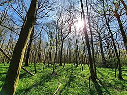
Pine trees and ravines dominate the central areas of the woodland
161:-covered northern and southern areas of the woodland, with large
231:
A bridge allows
Northlands Gill to flow into Upper Rapeland Wood
162:
158:
142:. It lies on Rapeland Hill, on the north-western fringes of
243:
Holly leaves on a plant in the north of the woodland
113:
74:
60:
49:
41:
23:
8:
363:Proceedings of the Geologists' Association
20:
262:"Upper Rapeland Wood, Horsham (RH12 4PP)"
336:Bernard Charles Worssam, A. A. Morter,
253:
193:
172:along the Faygate Syncline are on the
311:Henry Cleere; David Crossley (1995).
7:
406:Forests and woodlands of West Sussex
40:
338:The Stratigraphy of the Weald Clay
14:
318:. Merton Priory Press. p. 28
236:
224:
208:
196:
130:) is a mixed mature woodland in
48:
29:
112:
1:
365:, vol. 83, iss. 1, pp. 37–53.
313:"The Iron Industry of Weald"
16:Wood in West Sussex, England
422:
219:can be seen in these woods
357:Bernard Charles Worssam,
37:
28:
98:51.105611°N 0.304472°W
157:are prevalent in the
134:, a hamlet close to
128:Upper Rapelands Wood
117:0.04 sq mi (0.11 km)
103:51.105611; -0.304472
340:, p. 8, HMSO, 1978
124:Upper Rapeland Wood
94: /
24:Upper Rapeland Wood
56:, Horsham, England
121:
120:
413:
391:
390:
388:
386:
372:
366:
355:
349:
334:
328:
327:
325:
323:
317:
308:
302:
301:
299:
297:
283:
277:
276:
274:
272:
258:
240:
228:
212:
200:
109:
108:
106:
105:
104:
99:
95:
92:
91:
90:
87:
70:
33:
21:
421:
420:
416:
415:
414:
412:
411:
410:
396:
395:
394:
384:
382:
374:
373:
369:
356:
352:
335:
331:
321:
319:
315:
310:
309:
305:
295:
293:
285:
284:
280:
270:
268:
260:
259:
255:
251:
244:
241:
232:
229:
220:
217:common primrose
215:Plants such as
213:
204:
201:
192:
155:Broadleaf trees
102:
100:
96:
93:
88:
85:
83:
81:
80:
66:
17:
12:
11:
5:
419:
417:
409:
408:
398:
397:
393:
392:
367:
350:
329:
303:
278:
252:
250:
247:
246:
245:
242:
235:
233:
230:
223:
221:
214:
207:
205:
202:
195:
191:
188:
119:
118:
115:
111:
110:
78:
72:
71:
64:
58:
57:
51:
47:
46:
45:Mixed woodland
43:
39:
38:
35:
34:
26:
25:
15:
13:
10:
9:
6:
4:
3:
2:
418:
407:
404:
403:
401:
381:
377:
371:
368:
364:
360:
354:
351:
347:
343:
339:
333:
330:
314:
307:
304:
292:
288:
282:
279:
267:
266:OS GetOutside
263:
257:
254:
248:
239:
234:
227:
222:
218:
211:
206:
199:
194:
189:
187:
184:
182:
178:
175:
174:Horsham Stone
169:
166:
164:
160:
156:
151:
149:
145:
141:
137:
133:
129:
125:
116:
107:
79:
77:
73:
69:
65:
63:
59:
55:
52:
44:
36:
32:
27:
22:
19:
383:. Retrieved
379:
370:
362:
353:
337:
332:
320:. Retrieved
306:
294:. Retrieved
290:
281:
269:. Retrieved
265:
256:
185:
170:
167:
152:
144:Old Holbrook
132:Old Holbrook
127:
123:
122:
86:51°06′20.2″N
54:Old Holbrook
18:
380:maps.nls.uk
291:maps.nls.uk
126:(sometimes
101: /
89:0°18′16.1″W
76:Coordinates
249:References
181:sandstone
148:Graylands
400:Category
385:26 March
322:25 March
296:25 March
271:25 March
68:TQ188354
50:Location
346:5542184
190:Gallery
177:horizon
140:England
136:Horsham
62:OS grid
344:
316:(PDF)
387:2020
342:OCLC
324:2020
298:2020
273:2020
163:pine
159:moss
114:Area
42:Type
402::
378:.
361:,
289:.
264:.
150:.
138:,
389:.
348:.
326:.
300:.
275:.
Text is available under the Creative Commons Attribution-ShareAlike License. Additional terms may apply.