26:
260:. Periodic flooding prevents the extensive growth of herbaceous species. The diversity of wetland types (marshes, swamps, coastal lagoon, riverine margins and others) supports a wide diversity of species. Scientists have recorded 374 species of vascular plants, 134 species of mammals, 26 of amphibians, 85 of reptiles, 279 of birds, and 60 species of fish.
228:). This climate is characterized by relatively even temperatures throughout the year, and a pronounced dry season. The driest month has less than 60 mm of precipitation, and is drier than the average month. Precipitation in the ecoregion averages 1,600 mm/year.
48:
203:. They also cover the margins of the lagoon and inland for 5 km or so where the balance of saline and fresh water supports mangrove species. The lagoon is a RAMSAR wetland of international importance. The surrounding inland ecoregion is the
115:
272:
411:
225:
222:
439:
25:
459:
444:
449:
167:("Lagoon of Ends"). The "Ends" in the name refer to the mouths of the rivers that empty into the lagoon, including the
454:
217:
244:
164:
160:
250:
63:
204:
180:
30:
238:
172:
196:
168:
68:
386:
341:
200:
176:
433:
297:
47:
130:
117:
256:
152:
80:
179:, receives an estimated one-third of the wintering birds migrating on the
236:
The characteristic mangrove tree species in the region are red mangrove (
192:
156:
34:
319:
103:
38:
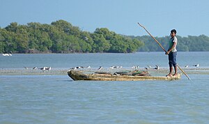
363:
183:. It is estimated that the lagoon supports 90 endangered species.
75:
385:
Kottek, M.; Grieser, J.; Beck, C.; Rudolf, B.; Rubel, F. (2006).
195:
State of Mexico. The mangroves cover the river deltas of the
387:"World Map of Koppen-Geiger Climate Classification Updated"
364:"Área de Protección de Flora y Fauna Laguna de Términos"
171:. This region, which is due south of the mouth of the
268:
Officially protected areas in the ecoregion include:
109:
99:
91:
86:
74:
62:
57:
18:
8:
412:"Dataset - Koppen climate classifications"
284:
254:). An associated species is the scrub
15:
292:
290:
288:
218:Tropical savanna climate - dry winter
95:3,108 km (1,200 sq mi)
7:
273:Pantanos de Centla Biosphere Reserve
191:The lagoon and surroundings are in
366:. RAMSAR Sites Information Service
14:
215:The climate of the ecoregion is
46:
24:
52:Ecoregion territory (in purple)
1:
223:Köppen climate classification
163:, around the margins of the
155:(WWF ID: NT1437) covers the
392:. Gebrüder Borntraeger 2006
344:. The Encyclopedia of Earth
300:. World Wildlife Federation
476:
322:. Resolve, using WWF data
45:
23:
320:"Map of Ecoregions 2017"
187:Location and description
248:), and black mangrove (
440:Neotropical ecoregions
342:"Usumacinta mangroves"
298:"Usumacinta mangroves"
245:Laguncularia racemosa
460:Gulf Coast of Mexico
445:Ecoregions of Mexico
161:Gulf Coast of Mexico
150:Usumacinta mangroves
19:Usumacinta mangroves
450:Mangrove ecoregions
251:Avicennia germinans
242:), white mangrove (
127: /
205:Pantanos de Centla
181:Mississippi Flyway
165:Laguna de Términos
31:Laguna de Terminos
257:Dalbergia brownii
239:Rhizophora mangle
173:Mississippi River
146:
145:
467:
455:Usumacinta River
424:
423:
421:
419:
408:
402:
401:
399:
397:
391:
382:
376:
375:
373:
371:
360:
354:
353:
351:
349:
338:
332:
331:
329:
327:
316:
310:
309:
307:
305:
294:
197:Usumacinta River
169:Usumacinta River
159:forests ont the
142:
141:
139:
138:
137:
132:
128:
125:
124:
123:
120:
50:
28:
16:
475:
474:
470:
469:
468:
466:
465:
464:
430:
429:
428:
427:
417:
415:
410:
409:
405:
395:
393:
389:
384:
383:
379:
369:
367:
362:
361:
357:
347:
345:
340:
339:
335:
325:
323:
318:
317:
313:
303:
301:
296:
295:
286:
281:
266:
264:Protected areas
234:
232:Flora and fauna
213:
189:
135:
133:
131:18.76°N 91.22°W
129:
126:
121:
118:
116:
114:
113:
53:
41:
33:, Isla Aguada,
12:
11:
5:
473:
471:
463:
462:
457:
452:
447:
442:
432:
431:
426:
425:
403:
377:
355:
333:
311:
283:
282:
280:
277:
276:
275:
265:
262:
233:
230:
212:
209:
201:Grijalva River
188:
185:
177:Gulf of Mexico
144:
143:
111:
107:
106:
101:
97:
96:
93:
89:
88:
84:
83:
78:
72:
71:
66:
60:
59:
55:
54:
51:
43:
42:
29:
21:
20:
13:
10:
9:
6:
4:
3:
2:
472:
461:
458:
456:
453:
451:
448:
446:
443:
441:
438:
437:
435:
418:September 14,
413:
407:
404:
396:September 14,
388:
381:
378:
365:
359:
356:
343:
337:
334:
321:
315:
312:
299:
293:
291:
289:
285:
278:
274:
271:
270:
269:
263:
261:
259:
258:
253:
252:
247:
246:
241:
240:
231:
229:
227:
224:
220:
219:
210:
208:
206:
202:
198:
194:
186:
184:
182:
178:
174:
170:
166:
162:
158:
154:
151:
140:
136:18.76; -91.22
112:
108:
105:
102:
98:
94:
90:
85:
82:
79:
77:
73:
70:
67:
65:
61:
56:
49:
44:
40:
36:
32:
27:
22:
17:
416:. Retrieved
414:. World Bank
406:
394:. Retrieved
380:
370:November 20,
368:. Retrieved
358:
348:November 20,
346:. Retrieved
336:
326:November 20,
324:. Retrieved
314:
304:November 20,
302:. Retrieved
267:
255:
249:
243:
237:
235:
216:
214:
190:
149:
147:
207:ecoregion.
175:across the
134: /
110:Coordinates
434:Categories
279:References
153:ecoregion
87:Geography
81:Mangroves
69:Neotropic
193:Campeche
157:mangrove
35:Campeche
211:Climate
122:91°13′W
119:18°46′N
100:Country
58:Ecology
104:Mexico
39:Mexico
390:(PDF)
76:Biome
64:Realm
420:2019
398:2019
372:2020
350:2020
328:2020
306:2020
226:(Aw)
199:and
148:The
92:Area
436::
287:^
37:,
422:.
400:.
374:.
352:.
330:.
308:.
221:(
Text is available under the Creative Commons Attribution-ShareAlike License. Additional terms may apply.