79:
112:
29:
46:
119:
86:
53:
78:
507:
502:
161:
111:
28:
268:
45:
331:. Its altitude is between 1,450 metres (4,760 ft) at the bottom of the station, and 2,100 metres (6,900 ft) at the top.
324:
154:
397:
328:
300:
260:
413:
381:, then occupied two of the first three places in the race. The stage departed from the Spanish town of
264:
292:
393:
370:
296:
280:
374:
312:
401:
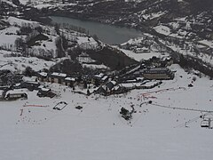
386:
465:
378:
441:
496:
316:
252:
219:
176:
163:
442:"Ski et neige - Holidays on the mountain, Valley Louron - Hautes-Pyrénées"
256:
418:
308:
304:
147:
209:
488:
234:
382:
320:
373:, and proved to be decisive. The riders arrived separately and
396:
also went through Val-Louron, although it took the descent by
327:
to the north-east, each situated at either end of the
283:, which is where the name of Val-Louron originated.
228:
218:
208:
200:
192:
153:
143:
21:
345:22 kilometres (14 mi) of alpine ski slopes
319:to the east. By road, the nearest communes are
369:Val-Louron was the finish for Stage 13 of the
8:
291:Val-Louron is specifically located in the
27:
18:
389:also featured in the route for the day.
430:
508:Tourist attractions in Hautes-Pyrénées
400:. The first rider over the summit was
460:
458:
436:
434:
7:
279:The ski station is located in the
118:
85:
52:
14:
377:, along with the eventual winner
117:
110:
84:
77:
51:
44:
503:Ski areas and resorts in France
199:
191:
489:Val-Louron ski station website
1:
204:1,450 m (4,760 ft)
196:2,150 m (7,050 ft)
33:A general view of Val-Louron
466:"Les Pyrenees - Val Louron"
524:
16:French mountain ski resort
38:
26:
357:5 circuits for snowshoes
315:, by a direct route, is
323:to the north-west, and
329:Col de Val Louron-Azet
98:Val-Louron (Occitanie)
65:Location within France
131:Val-Louron (Pyrenees)
101:Show map of Occitanie
134:Show map of Pyrenees
394:2005 Tour de France
371:1991 Tour de France
301:Bagnères-de-Bigorre
201:Base elevation
173: /
375:Claudio Chiappucci
177:42.7903°N 0.3897°E
144:Nearest major city
68:Show map of France
246:
245:
515:
477:
476:
474:
472:
462:
453:
452:
450:
448:
438:
408:Related articles
402:Laurent Brochard
392:Stage 15 of the
387:Col du Tourmalet
242:
241:
238:
236:
188:
187:
185:
184:
183:
178:
174:
171:
170:
169:
166:
135:
121:
120:
114:
102:
88:
87:
81:
69:
55:
54:
48:
31:
19:
523:
522:
518:
517:
516:
514:
513:
512:
493:
492:
486:
481:
480:
470:
468:
464:
463:
456:
446:
444:
440:
439:
432:
427:
414:Hautes-Pyrénées
410:
398:Val-Louron-Azet
379:Miguel Indurain
367:
342:
337:
299:, southeast of
289:
277:
265:Hautes-Pyrénées
237:.val-louron-ski
233:
232:
182:42.7903; 0.3897
181:
179:
175:
172:
167:
164:
162:
160:
159:
139:
138:
137:
136:
133:
132:
129:
128:
127:
126:
122:
105:
104:
103:
100:
99:
96:
95:
94:
93:
89:
72:
71:
70:
67:
66:
63:
62:
61:
60:
56:
34:
17:
12:
11:
5:
521:
519:
511:
510:
505:
495:
494:
485:
484:External links
482:
479:
478:
454:
429:
428:
426:
423:
422:
421:
416:
409:
406:
366:
365:Tour de France
363:
362:
361:
358:
355:
352:
349:
346:
341:
338:
336:
335:Infrastructure
333:
311:. The nearest
288:
285:
276:
273:
255:in the French
244:
243:
230:
226:
225:
222:
216:
215:
212:
206:
205:
202:
198:
197:
194:
190:
189:
157:
151:
150:
145:
141:
140:
130:
124:
123:
116:
115:
109:
108:
107:
106:
97:
91:
90:
83:
82:
76:
75:
74:
73:
64:
58:
57:
50:
49:
43:
42:
41:
40:
39:
36:
35:
32:
24:
23:
15:
13:
10:
9:
6:
4:
3:
2:
520:
509:
506:
504:
501:
500:
498:
491:
490:
483:
467:
461:
459:
455:
443:
437:
435:
431:
424:
420:
417:
415:
412:
411:
407:
405:
403:
399:
395:
390:
388:
384:
380:
376:
372:
364:
359:
356:
353:
351:46 snow guns
350:
347:
344:
343:
339:
334:
332:
330:
326:
322:
318:
314:
310:
306:
302:
298:
297:Louron Valley
294:
286:
284:
282:
281:Louron Valley
274:
272:
270:
266:
262:
258:
254:
250:
240:
231:
227:
223:
221:
217:
213:
211:
207:
203:
195:
193:Top elevation
186:
158:
156:
152:
149:
146:
142:
113:
80:
47:
37:
30:
25:
20:
487:
469:. Retrieved
445:. Retrieved
391:
368:
317:Loudenvielle
290:
278:
248:
247:
224:46 snow guns
293:Pays d'Aure
180: /
155:Coordinates
497:Categories
425:References
267:, and the
261:department
253:ski resort
249:Val-Louron
220:Snowmaking
165:42°47′25″N
125:Val-Louron
92:Val-Louron
59:Val-Louron
22:Val-Louron
360:Sled dogs
348:19 tracks
287:Geography
269:Occitania
259:, in the
168:0°23′23″E
385:and the
354:12 lifts
340:Ski area
275:Toponymy
271:region.
257:Pyrenees
471:12 July
447:12 July
419:Bigorre
313:commune
309:Bigorre
295:in the
229:Website
305:Tarbes
210:Trails
148:Tarbes
325:Génos
307:, in
251:is a
473:2014
449:2014
383:Jaca
321:Azet
303:and
239:.com
263:of
235:www
499::
457:^
433:^
404:.
214:19
475:.
451:.
Text is available under the Creative Commons Attribution-ShareAlike License. Additional terms may apply.