310:
518:
31:
348:
eastern abutment and several concrete footings are still in place near the rim of the ravine as reminders of the old bridge. After completion of the new structure, the old one was promptly dismantled, and the material used to forge the fence that lines Avoca Avenue along the west side of the ravine. The Yellow Creek stream at the bottom was subsequently channelized to slow erosion.
347:
The old bridge remained open and operational throughout, with traffic detouring around construction on the eastern side. The former structure crossed the valley on an angle, beginning at St. Clair in the east and crossing to
Pleasant Boulevard; it followed an electric line already in place. The
344:
and demolished, and the new structure built over two years at the cost of $ 716,653.58 (equivalent to $ 12.24 million in 2023) It opened to traffic in
November or December, 1924.
340:
authorized construction of a new bridge in 1922. Unlike the old bridge, this one would follow the straight alignment of St. Clair Avenue East (renamed in 1914). Two houses were
439:
Two photos from the
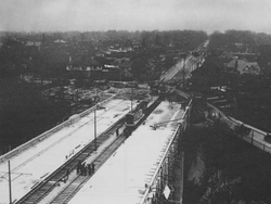
Toronto Archives taken on November 3 and December 16 show the paving of the completed structure, and the demolition of the old structure, respectively.
294:) consists of a nature trail that winds through the Vale of Avoca Ravine; the park also includes a grassy recreational area near an inlet into which Yellow Creek flows.
664:
506:
336:
into
Toronto at the instigation of landowners eager to obtain municipal services. Due to growing safety concerns regarding the old iron bridge,
48:
636:
484:
499:
641:
539:
321:
in the hopes of encouraging investment in his new subdivision, Moore Park. Under the condition that he build the bridge, the
728:
674:
326:
275:
in the 1920s. The bridge replaced an older structure and straightened the alignment of St. Clair Avenue in the process.
212:
41:
733:
492:
684:
656:
618:
522:
352:
626:
573:
563:
325:
purchased a strip of land across the valley and leased it to Moore, who was in return given the St. Clair Avenue
583:
391:
Laura had gone through a Danger barrier, then right off the St. Clair Avenue bridge into the ravine far below.
697:
707:
692:
631:
608:
598:
283:
180:
127:
98:
702:
593:
531:
287:
578:
337:
568:
555:
544:
317:
The first bridge over the Vale of Avoca was an iron bridge, built in 1888. The bridge was built by
279:
272:
384:
268:
318:
142:
738:
322:
309:
291:
252:
248:
108:
84:
380:
165:
418:
603:
341:
30:
722:
588:
360:
298:
256:
364:
260:
467:
419:"Report on the Vale of Avoca - Old History of the Place and Surrounding Area"
63:
50:
175:
387:
begins on the recounting of a car accident at the Vale of Avoca bridge:
646:
517:
368:
333:
244:
308:
313:
The Vale of Avoca bridge under construction in the winter of 1923
488:
297:
The bridge and the ravine it crosses is named after a poem by
454:
Deer Park
Library. Local history reference; 'Bridges' fonds
267:, was built to connect the well-established community of
355:
officially named the bridge structure and the ravine as
683:
655:
617:
553:
529:
229:
221:
211:
206:
191:
186:
174:
164:
156:
148:
138:
133:
123:
115:
104:
94:
79:
40:
21:
363:(after whom John Thomas Moore is named), or the
35:Vale of Avoca nears completion, November 3, 1924
389:
665:Cherry Street Strauss Trunnion Bascule Bridge
500:
8:
412:
410:
89:(originally 4 lanes with 2 streetcar tracks)
286:, weaves beneath the central span. Much of
507:
493:
485:
329:between Avoca Avenue and Inglewood Drive.
18:
396:Margaret Atwood, The Blind Assassin, 2000
447:
445:
406:
332:On December 16, 1912, Moore Park was
278:A small channelized tributary of the
7:
462:
460:
371:. The bridge was renovated in 1985.
251:over a ravine of the same name, in
637:Lake Shore Boulevard Bailey Bridge
14:
271:with the developing community of
516:
29:
255:, Canada. Located just east of
642:Old Finch Avenue Bailey Bridge
540:Old Finch Avenue Bailey Bridge
1:
657:Other bridges over waterways
359:, after either the poem by
755:
470:. Lost River Walks Toronto
452:Bridge over Vale of Avoca.
353:City of Toronto government
152:155.1 m (509 ft)
574:Old Eastern Avenue Bridge
564:Cherry Street lift bridge
234:
28:
16:Bridge in Ontario, Canada
417:Chartash, David (2001).
160:19.7 m (65 ft)
698:Dufferin Street bridges
292:Toronto city councillor
243:is the name of a large
64:43.689160°N 79.388882°W
708:Sir Isaac Brock Bridge
693:Crawford Street Bridge
632:Humber Bay Arch Bridge
609:Sheppard Avenue Bridge
599:Rosedale Valley Bridge
421:. Deer Park Newsletter
399:
314:
170:27 m (89 ft)
128:Toronto Transportation
99:Vale of Avoca (ravine)
703:Harbord Street Bridge
594:Prince Edward Viaduct
584:Gerrard Street Bridge
312:
288:David A. Balfour Park
259:, the current triple
249:St. Clair Avenue East
217:St. Clair Avenue East
69:43.689160; -79.388882
729:Landforms of Toronto
670:Vale of Avoca Bridge
589:Dundas Street Bridge
579:Queen Street Viaduct
338:Toronto City Council
263:, also known as the
569:Gardiner Expressway
545:Sewells Road Bridge
468:"St. Clair Viaduct"
60: /
734:Bridges in Toronto
523:Bridges in Toronto
385:The Blind Assassin
375:Popular references
315:
716:
715:
675:Governor's Bridge
357:The Vale of Avoca
319:John Thomas Moore
265:St. Clair Viaduct
238:
237:
143:Truss arch bridge
119:St. Clair Viaduct
90:
746:
627:Amsterdam Bridge
521:
520:
509:
502:
495:
486:
480:
479:
477:
475:
464:
455:
449:
440:
437:
431:
430:
428:
426:
414:
397:
367:river valley in
323:Township of York
202:
200:
109:Toronto, Ontario
88:
85:St. Clair Avenue
75:
74:
72:
71:
70:
65:
61:
58:
57:
56:
53:
33:
19:
754:
753:
749:
748:
747:
745:
744:
743:
719:
718:
717:
712:
679:
651:
613:
549:
525:
515:
513:
483:
473:
471:
466:
465:
458:
450:
443:
438:
434:
424:
422:
416:
415:
408:
404:
398:
395:
381:Margaret Atwood
377:
307:
290:(named for the
198:
196:
176:Clearance below
166:Clearance above
134:Characteristics
87:
68:
66:
62:
59:
54:
51:
49:
47:
46:
36:
24:
17:
12:
11:
5:
752:
750:
742:
741:
736:
731:
721:
720:
714:
713:
711:
710:
705:
700:
695:
689:
687:
681:
680:
678:
677:
672:
667:
661:
659:
653:
652:
650:
649:
644:
639:
634:
629:
623:
621:
615:
614:
612:
611:
606:
604:Leaside Bridge
601:
596:
591:
586:
581:
576:
571:
566:
560:
558:
551:
550:
548:
547:
542:
536:
534:
530:Crossing the
527:
526:
514:
512:
511:
504:
497:
489:
482:
481:
456:
441:
432:
405:
403:
400:
393:
379:The events in
376:
373:
306:
303:
247:which carries
236:
235:
232:
231:
227:
226:
223:
219:
218:
215:
209:
208:
204:
203:
193:
189:
188:
184:
183:
178:
172:
171:
168:
162:
161:
158:
154:
153:
150:
146:
145:
140:
136:
135:
131:
130:
125:
121:
120:
117:
113:
112:
106:
102:
101:
96:
92:
91:
81:
77:
76:
44:
38:
37:
34:
26:
25:
22:
15:
13:
10:
9:
6:
4:
3:
2:
751:
740:
737:
735:
732:
730:
727:
726:
724:
709:
706:
704:
701:
699:
696:
694:
691:
690:
688:
686:
682:
676:
673:
671:
668:
666:
663:
662:
660:
658:
654:
648:
645:
643:
640:
638:
635:
633:
630:
628:
625:
624:
622:
620:
616:
610:
607:
605:
602:
600:
597:
595:
592:
590:
587:
585:
582:
580:
577:
575:
572:
570:
567:
565:
562:
561:
559:
557:
554:Crossing the
552:
546:
543:
541:
538:
537:
535:
533:
528:
524:
519:
510:
505:
503:
498:
496:
491:
490:
487:
469:
463:
461:
457:
453:
448:
446:
442:
436:
433:
420:
413:
411:
407:
401:
392:
388:
386:
382:
374:
372:
370:
366:
362:
358:
354:
351:In 1973, the
349:
345:
343:
339:
335:
330:
328:
324:
320:
311:
304:
302:
300:
295:
293:
289:
285:
281:
276:
274:
270:
266:
262:
258:
254:
250:
246:
242:
241:Vale of Avoca
233:
228:
224:
220:
216:
214:
213:Daily traffic
210:
205:
194:
190:
185:
182:
179:
177:
173:
169:
167:
163:
159:
155:
151:
147:
144:
141:
137:
132:
129:
126:
124:Maintained by
122:
118:
116:Other name(s)
114:
110:
107:
103:
100:
97:
93:
86:
82:
78:
73:
45:
43:
39:
32:
27:
23:Vale of Avoca
20:
669:
474:December 27,
472:. Retrieved
451:
435:
425:December 27,
423:. Retrieved
390:
378:
361:Thomas Moore
356:
350:
346:
342:expropriated
331:
327:right-of-way
316:
299:Thomas Moore
296:
284:Yellow Creek
277:
264:
257:Yonge Street
240:
239:
181:Yellow Creek
149:Total length
532:Rouge River
365:River Avoca
282:, known as
261:arch bridge
83:5 lanes of
67: /
42:Coordinates
723:Categories
619:Pedestrian
402:References
273:Moore Park
207:Statistics
55:79°23′20″W
52:43°41′21″N
556:Don River
383:'s novel
280:Don River
269:Deer Park
394:—
230:Location
111:, Canada
739:Ravines
647:SkyWalk
369:Ireland
334:annexed
305:History
253:Toronto
245:viaduct
197: (
187:History
95:Crosses
80:Carries
192:Opened
139:Design
105:Locale
685:Other
157:Width
476:2010
427:2010
222:Toll
199:1924
195:1924
725::
459:^
444:^
409:^
301:.
225:No
508:e
501:t
494:v
478:.
429:.
201:)
Text is available under the Creative Commons Attribution-ShareAlike License. Additional terms may apply.