336:
66:
231:, concerns about water quality, pollution and adequate sewage disposal became widespread. Decades of proposals for sewage disposal and water supply systems followed, coupled with disagreement between the Town Councils and the Colony Government about responsibility for this area. An extensive water supply scheme was eventually compiled by the civil engineers
314:
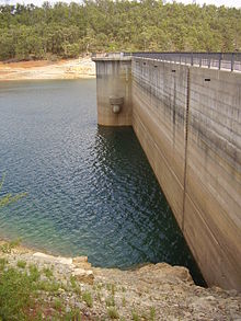
from the concrete, weakening the structure. Efforts to reduce the leaking occurred in 1912, and in 1966 the upstream side of the dam wall was covered with reinforced concrete to reduce further leaking. However, a 1988 review of the dam's design concluded that it lacked sufficient safety margins in
292:
occurred at a timber mill in the catchment in 1892, at a time when typhoid fever became increasingly prevalent in Perth. Between 1895 and 1900, there were 4047 cases and 425 deaths from typhoid fever in Perth, and the water supply was suspected to be contaminated. In response to this, in 1896 the
238:
The scheme designed by
Saunders and Barratt contained full designs, site surveys and runoff estimates, despite no guarantee of approval or financial incentive. The plan included reticulation for both Perth and Fremantle. In July and August 1887, a Legislative Council Select Committee appointed to
277:
The concrete dam wall was built using approximately 1,260 tonnes (1,240 long tons; 1,390 short tons) of cement imported from
England. The dam wall was a concrete gravity-arch structure, designed in the plan of a large-radius arch. The volume of the concrete in the finished wall was 16,900 cubic
250:
The site of the proposed reservoir is some 17 miles from Perth, and lies in a hollow of the hills, apparently intended by Nature for some such purpose, surrounded by the jarrah forest. At the lower end the hills approach comparatively close together, where it is proposed to construct the
508:
Due to the construction methods used, the dam was completed less than a year after excavation began on its foundations, halving the time it would have taken had more conventional methods been employed. The dam was officially opened on 22 November 1991 by
239:
examine the proposal passed the issue back to local government. Fremantle refused to participate in the water supply scheme, so following the departure from the Civil
Engineering partnership of Barratt, Saunders removed Fremantle from the plan.
493:(RCC), rather than the more traditional method of large concrete pours or earthfill. It was the first dam built in Western Australia using this method, and at the time was the largest of this type built in Australia. Also, instead of using
485:
The decision to replace the Old
Victoria Dam was made in 1989. Use of the old dam for water supply ended on 3 April 1990, and the old dam was partially demolished. Construction on the new dam started on 23 August 1990.
293:
Colonial
Government purchased the scheme, including the dam, pipelines and Mount Eliza reservoir. In 1897, a sample of the water from the reservoir was found to contain the bacteria causing typhoid fever, and strict
829:
285:
settlements. As soon after completion as 1892, concerns were raised that this new water source was getting polluted by raw sewage from the timber mills as well as excrement from the livestock.
297:
were implemented to prosecute any cases of pollution of the water catchment. Also, a channel was cut to divert the Munday Brook water (polluted by the timber mills) away from the reservoir.
570:
528:, and also supplies the rest of the metropolitan area in times of peak demand. The area is not open to full public access; it can only be visited by the public via walking trails.
734:
606:
41:, and crosses Munday Brook. Two dams have stood at the present site; the older dam was the first permanent water supply for the colony and also the first dam in
370:
100:
824:
809:
778:
537:
720:
pp.58–59 gives a divergent version of the history of the construction, and in particular a colourful description of the opening of the reservoir.
581:
768:
502:
640:
274:, was constructed and operated by the private City of Perth Waterworks Company. The dam became the first permanent water source for Perth.
315:
the event of floods or earthquakes, and its concrete had degraded to such a level that it could not be repaired, and needed replacement.
819:
717:
648:
686:
804:
799:
744:
632:
636:
271:
267:
525:
521:
228:
38:
542:
308:
814:
490:
281:
At the time, the catchment area for the reservoir was used for cattle and sheep grazing and also housed several
357:
242:
The Colony
Government passed enabling legislation, and some privately owned land covering the reservoir was
505:
was used, which reduced costs and minimised the heat produced during the hardening of the concrete.
666:
257:
232:
426:
160:
773:
713:
644:
600:
227:, natural bodies of water and rainwater tanks. With the growth in the population of Perth and
42:
150:
223:
Prior to the constriction of the dam, residents of Perth sourced their drinking water from
494:
335:
65:
462:
311:
243:
204:
784:
793:
289:
34:
510:
26:
730:
517:
282:
489:
The new
Victoria Dam wall was constructed just upstream from the old dam using
224:
681:
385:
372:
115:
102:
266:
Construction was completed in 1891. The scheme, which included pipelines to
45:. It stood for almost 100 years before being replaced with the current dam.
629:
A Historical
Archaeological Study of Victoria Reservoir and its Catchment
301:
690:. Perth, WA: National Library of Australia. 5 September 1913. p. 24
739:
498:
710:
Cala Munnda : a home in the forest : a history of
Kalamunda
294:
682:"THE MAIN SOURCES OF THE METROPOLITAN WATER SUPPLY. E. L. Mitchell"
87:
30:
580:. Australian Geomechanics Symposium. p. 1. Archived from
145:
304:. In 1939, one of these was closed and the other expanded.
830:
State
Register of Heritage Places in the City of Kalamunda
785:
Consultant's project page for the dam, including gallery
300:
The dam as originally constructed featured two small
471:
461:
453:
448:
440:
432:
422:
417:
409:
401:
364:
353:
345:
328:
213:
203:
195:
187:
182:
174:
166:
156:
144:
139:
131:
94:
83:
75:
58:
569:Bulley, B., Wark, B. & Somerford, M. (2003).
779:Gallery of external and internal dam photographs
631:. Prepared on behalf of Centre for Prehistory,
248:
664:"The Perth Water Works: Visit of inspection".
8:
781:(includes photographs of information boards)
605:: CS1 maint: multiple names: authors list (
712:Kalamunda, W.A. : Shire of Kalamunda.
687:Western Mail (Perth, WA : 1885 – 1954)
33:, Western Australia. It is situated on the
334:
325:
64:
55:
564:
562:
560:
558:
513:, then the Minister for Water Resources.
622:
620:
618:
616:
538:List of reservoirs and dams in Australia
199:600 ML (21,000,000 cu ft)
554:
278:metres (0.60 million cubic feet).
598:
340:New Victoria Dam at 30.6% of capacity
7:
641:Water Authority of Western Australia
29:dam providing water for the city of
774:Structurae: New Victoria Dam (1991)
475:0.77 km (0.30 sq mi)
307:Water leaking through the dam wall
217:0.15 km (0.06 sq mi)
209:37.2 km (14.4 sq mi)
735:"Legislative Assembly – Grievance"
516:The new dam supplies water to the
14:
467:37 km (14.3 sq mi)
825:1991 establishments in Australia
769:Dam storage level and statistics
578:The Engineering Geology of Perth
235:and James Barratt in June 1887.
810:Reservoirs in Western Australia
745:Parliament of Western Australia
633:University of Western Australia
319:New Victoria Dam (1991–present)
53:Dam in Perth, Western Australia
16:Dam in Perth, Western Australia
627:Wesson, Jane (November 1989).
1:
670:. 3 December 1889. p. 3.
70:The Old and New Victoria Dams
49:Old Victoria Dam (1891–1990)
571:"Dams in the Darling Range"
543:List of reservoirs and dams
846:
820:Dams in Western Australia
491:roller-compacted concrete
479:
333:
270:and a reservoir there on
63:
444:285 m (935 ft)
178:220 m (722 ft)
503:Muja Coal Power Station
436:52 m (171 ft)
402:Construction began
323:Dam in Perth, Australia
805:Dams completed in 1991
800:Dams completed in 1891
386:32.04250°S 116.06722°E
264:
170:23 m (75 ft)
116:32.04028°S 116.06667°E
733:(23 September 2004).
146:Type of dam
391:-32.04250; 116.06722
121:-32.04028; 116.06667
708:Slee, John. (1979)
667:The West Australian
463:Catchment area
382: /
258:The West Australian
233:Henry John Saunders
205:Catchment area
196:Total capacity
112: /
90:, Western Australia
643:. pp. 16–72.
457:Victoria Reservoir
191:Victoria Reservoir
815:Arch-gravity dams
483:
482:
472:Surface area
418:Dam and spillways
410:Opening date
288:Several cases of
261:, 3 December 1889
221:
220:
214:Surface area
140:Dam and spillways
132:Opening date
43:Western Australia
837:
756:
755:
753:
751:
727:
721:
706:
700:
699:
697:
695:
678:
672:
671:
661:
655:
654:
624:
611:
610:
604:
596:
594:
592:
586:
575:
566:
413:22 November 1991
397:
396:
394:
393:
392:
387:
383:
380:
379:
378:
375:
338:
329:New Victoria Dam
326:
262:
151:Arch-gravity dam
127:
126:
124:
123:
122:
117:
113:
110:
109:
108:
105:
68:
59:Old Victoria Dam
56:
845:
844:
840:
839:
838:
836:
835:
834:
790:
789:
765:
760:
759:
749:
747:
729:
728:
724:
707:
703:
693:
691:
680:
679:
675:
663:
662:
658:
651:
626:
625:
614:
597:
590:
588:
587:on 14 July 2005
584:
573:
568:
567:
556:
551:
534:
390:
388:
384:
381:
376:
373:
371:
369:
368:
341:
324:
321:
263:
255:
120:
118:
114:
111:
106:
103:
101:
99:
98:
71:
54:
51:
17:
12:
11:
5:
843:
841:
833:
832:
827:
822:
817:
812:
807:
802:
792:
791:
788:
787:
782:
776:
771:
764:
763:External links
761:
758:
757:
722:
701:
673:
656:
649:
612:
553:
552:
550:
547:
546:
545:
540:
533:
530:
481:
480:
477:
476:
473:
469:
468:
465:
459:
458:
455:
451:
450:
446:
445:
442:
438:
437:
434:
430:
429:
424:
420:
419:
415:
414:
411:
407:
406:
405:23 August 1990
403:
399:
398:
366:
362:
361:
355:
351:
350:
347:
343:
342:
339:
331:
330:
322:
320:
317:
253:
219:
218:
215:
211:
210:
207:
201:
200:
197:
193:
192:
189:
185:
184:
180:
179:
176:
172:
171:
168:
164:
163:
158:
154:
153:
148:
142:
141:
137:
136:
135:1 October 1891
133:
129:
128:
96:
92:
91:
85:
81:
80:
77:
73:
72:
69:
61:
60:
52:
50:
47:
15:
13:
10:
9:
6:
4:
3:
2:
842:
831:
828:
826:
823:
821:
818:
816:
813:
811:
808:
806:
803:
801:
798:
797:
795:
786:
783:
780:
777:
775:
772:
770:
767:
766:
762:
746:
742:
741:
736:
732:
726:
723:
719:
718:0-9595831-0-6
715:
711:
705:
702:
689:
688:
683:
677:
674:
669:
668:
660:
657:
652:
650:0-7309-3718-6
646:
642:
638:
634:
630:
623:
621:
619:
617:
613:
608:
602:
583:
579:
572:
565:
563:
561:
559:
555:
548:
544:
541:
539:
536:
535:
531:
529:
527:
523:
519:
514:
512:
506:
504:
500:
496:
492:
487:
478:
474:
470:
466:
464:
460:
456:
452:
447:
443:
439:
435:
431:
428:
425:
421:
416:
412:
408:
404:
400:
395:
367:
363:
359:
356:
352:
348:
346:Official name
344:
337:
332:
327:
318:
316:
313:
310:
305:
303:
298:
296:
291:
290:typhoid fever
286:
284:
279:
275:
273:
269:
260:
259:
252:
247:
245:
240:
236:
234:
230:
226:
216:
212:
208:
206:
202:
198:
194:
190:
186:
181:
177:
173:
169:
165:
162:
159:
155:
152:
149:
147:
143:
138:
134:
130:
125:
97:
93:
89:
86:
82:
78:
76:Official name
74:
67:
62:
57:
48:
46:
44:
40:
36:
35:Darling Scarp
32:
28:
24:
19:
748:. Retrieved
738:
731:Ripper, Eric
725:
709:
704:
692:. Retrieved
685:
676:
665:
659:
628:
589:. Retrieved
582:the original
577:
515:
511:Ernie Bridge
507:
497:in the RCC,
488:
484:
427:Munday Brook
349:Victoria Dam
306:
299:
287:
280:
276:
265:
256:
249:
241:
237:
222:
161:Munday Brook
79:Victoria Dam
27:water supply
23:Victoria Dam
22:
20:
18:
637:Leederville
520:suburbs of
518:Perth Hills
389: /
377:116°04′02″E
365:Coordinates
360:, Australia
283:timber mill
272:Mount Eliza
251:embankment.
119: /
107:116°04′00″E
95:Coordinates
794:Categories
549:References
374:32°02′33″S
268:Kings Park
104:32°02′25″S
526:Lesmurdie
522:Kalamunda
501:from the
449:Reservoir
302:spillways
229:Fremantle
183:Reservoir
39:Lesmurdie
750:14 March
601:cite web
591:14 March
532:See also
423:Impounds
354:Location
254:—
157:Impounds
84:Location
740:Hansard
694:7 April
499:fly ash
454:Creates
309:leached
295:by-laws
244:resumed
188:Creates
716:
647:
495:cement
441:Length
433:Height
175:Length
167:Height
585:(PDF)
574:(PDF)
358:Perth
225:wells
88:Perth
37:near
31:Perth
25:is a
752:2008
714:ISBN
696:2012
645:ISBN
607:link
593:2008
524:and
312:lime
21:The
796::
743:.
737:.
684:.
639::
635:.
615:^
603:}}
599:{{
576:.
557:^
246:.
754:.
698:.
653:.
609:)
595:.
Text is available under the Creative Commons Attribution-ShareAlike License. Additional terms may apply.