151:
184:
1819:
906:
625:
1796:
883:
1784:
894:
131:
25:
506:
191:
158:
385:
The sea is a major fishing ground for sardines, mackerel, and herring the
Philippines. In 2020, the Western Visayas accounts for 20 percent of sardines total production in the Philippines. The sea covers an area of roughly 10,000 km (3,900 sq mi) with 22 municipalities along its
587:
1860:
386:
coastline. A closed season is imposed annually from
November 15 to March 15 in portions of the sea through Fisheries Administrative Order (FAO) 167 since 1989.
518:
Rudolf Hermes; Nygiel B. Armada; Remia A. Aparri; Ester C. Zaragoza; Uwe
Lohmeyer (2004). "Overexploitation in the Visayan Sea: Designing a Project Solution".
183:
150:
476:
943:
580:
244:
1889:
1853:
1879:
556:
532:
108:
1884:
886:
573:
46:
1846:
89:
61:
42:
542:
Rudolf Hermes (2004). "Marine
Protected Areas: Urgent Call for an Offshore Marine Sanctuary under Republic Act 8550".
1162:
936:
68:
35:
75:
1114:
510:
1435:
960:
956:
929:
802:
777:
57:
752:
1282:
812:
1583:
1377:
1006:
674:
1578:
1475:
1119:
981:
910:
782:
458:
833:
1818:
1337:
1287:
1079:
1021:
747:
712:
552:
528:
352:
135:
1830:
1598:
1450:
1001:
448:
325:
1718:
1688:
1668:
1588:
1252:
1247:
1232:
1202:
1167:
1089:
986:
762:
737:
727:
702:
669:
379:
360:
1362:
797:
368:
82:
624:
1658:
1638:
1603:
1593:
1573:
1568:
1563:
1392:
1382:
1272:
1257:
1139:
991:
968:
787:
772:
767:
717:
707:
654:
333:
298:
1873:
1800:
1788:
1608:
1500:
1470:
1455:
1445:
1425:
1352:
1322:
1277:
1267:
1242:
1222:
1192:
1172:
1084:
1059:
898:
853:
792:
742:
614:
462:
341:
276:
453:
436:
1783:
1653:
1528:
1480:
1465:
1460:
1440:
1407:
1387:
1372:
1357:
1332:
1317:
1307:
1262:
1217:
1207:
1197:
1182:
1147:
1069:
1051:
976:
921:
893:
843:
757:
477:"A tale of two seas: Closed season is a mixed bag for Philippine sardines industry"
222:
130:
1826:
1731:
1683:
1678:
1673:
1628:
1623:
1553:
1548:
1543:
1508:
1420:
1415:
1367:
1342:
1157:
1109:
1104:
1074:
1064:
1041:
1011:
732:
722:
664:
649:
644:
600:
372:
348:
317:
304:
24:
1767:
1741:
1708:
1698:
1643:
1523:
1430:
1397:
1327:
1297:
1292:
1237:
1227:
1187:
1177:
1152:
1124:
1099:
1031:
1016:
868:
863:
848:
838:
828:
807:
543:
519:
364:
259:
246:
1663:
1633:
1558:
1538:
1533:
1518:
1490:
1347:
1312:
1302:
1212:
1129:
1036:
996:
858:
659:
639:
356:
565:
505:
407:
1736:
1726:
1693:
1648:
1618:
1613:
1513:
1094:
1026:
681:
1485:
321:
291:
227:
16:
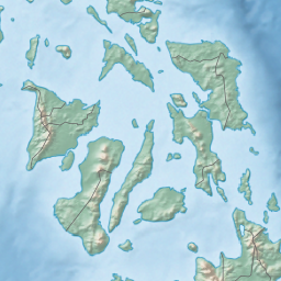
Sea in the
Philippines between Masbate, Leyte, Cebu, Negros and Panay
1757:
952:
329:
437:"Closed Season Policy in Visayan Sea, Philippines: A Second Look"
337:
925:
569:
527:. Bureau of Fisheries and Aquatic Resources. pp. 312–317.
1762:
596:
281:
18:
545:
In
Turbulent Seas: The Status of Philippine Marine Fisheries
521:
In
Turbulent Seas: The Status of Philippine Marine Fisheries
435:
Napata, Ruby; Espectato, Liberty; Serofia, Genna (2020).
1834:
347:
The sea is connected to several bodies of water: the
1750:
1717:
1499:
1406:
1138:
1050:
967:
821:
695:
632:
607:
297:
287:
275:
236:
215:
123:
49:. Unsourced material may be challenged and removed.
408:"Visayan Sea closed season starts Nov. 15: BFAR"
237:
430:
428:
1854:
937:
581:
8:
1861:
1847:
944:
930:
922:
588:
574:
566:
120:
452:
109:Learn how and when to remove this message
395:
378:The largest island within this sea is
1825:This article about a location in the
401:
399:
7:
1815:
1813:
47:adding citations to reliable sources
190:
157:
1833:. You can help Knowledge (XXG) by
14:
320:surrounded by the islands of the
1817:
1795:
1794:
1782:
904:
892:
882:
881:
623:
504:
363:to the southwest which leads to
189:
182:
156:
149:
129:
23:
454:10.1016/j.ocecoaman.2020.105115
324:. It is bounded by the islands
170:Location within the Philippines
34:needs additional citations for
441:Ocean & Coastal Management
1:
214:
1890:Philippines geography stubs
481:Mongabay Environmental News
1906:
1812:
1163:American Mediterranean Sea
1776:
877:
621:
351:to the northwest via the
203:Visayan Sea (Philippines)
143:
128:
1880:Geography of the Visayas
969:Antarctic/Southern Ocean
1885:Seas of the Philippines
1115:Prince Gustaf Adolf Sea
206:Show map of Philippines
1436:Great Australian Bight
911:Philippines portal
412:Philippine News Agency
371:to the south, and the
359:to the northeast, the
260:11.50000°N 123.66667°E
778:San Bernardino Strait
513:at Wikimedia Commons
1283:Gulf of St. Lawrence
813:Verde Island Passage
551:. pp. 223–225.
43:improve this article
1584:Gulf of Carpentaria
1378:Sea of the Hebrides
1007:King Haakon VII Sea
675:West Philippine Sea
265:11.50000; 123.66667
256: /
173:Show map of Visayas
1579:Gulf of California
1476:Mozambique Channel
1120:Queen Victoria Sea
982:Bellingshausen Sea
803:Tapiantana Channel
783:San Juanico Strait
483:. 18 February 2021
382:of Cebu province.
375:to the southeast.
138:in the Visayan Sea
1842:
1841:
1810:
1809:
1789:Oceans portal
1338:Mediterranean Sea
1288:Gulf of Venezuela
1080:East Siberian Sea
1022:Riiser-Larsen Sea
919:
918:
899:Oceans portal
748:Jintotolo Channel
713:Balintang Channel
509:Media related to
353:Jintotolo Channel
336:to the east, and
310:
309:
136:Islas de Gigantes
119:
118:
111:
93:
1897:
1863:
1856:
1849:
1821:
1814:
1798:
1797:
1787:
1786:
1719:Endorheic basins
1599:Gulf of Thailand
1451:Gulf of Khambhat
946:
939:
932:
923:
909:
908:
907:
897:
896:
885:
884:
753:Linapacan Strait
627:
590:
583:
576:
567:
562:
550:
538:
526:
508:
493:
492:
490:
488:
473:
467:
466:
456:
432:
423:
422:
420:
418:
403:
316:is a sea in the
271:
270:
268:
267:
266:
261:
257:
254:
253:
252:
249:
239:
207:
193:
192:
186:
174:
160:
159:
153:
133:
121:
114:
107:
103:
100:
94:
92:
51:
27:
19:
1905:
1904:
1900:
1899:
1898:
1896:
1895:
1894:
1870:
1869:
1868:
1867:
1811:
1806:
1781:
1772:
1746:
1713:
1689:South China Sea
1669:Seto Inland Sea
1589:Gulf of Fonseca
1495:
1402:
1253:Gulf of Finland
1248:Gulf of Bothnia
1233:English Channel
1203:Bay of Campeche
1168:Archipelago Sea
1134:
1090:Gulf of Boothia
1046:
987:Cooperation Sea
963:
950:
920:
915:
905:
903:
891:
873:
817:
763:Maqueda Channel
738:Guimaras Strait
728:Canigao Channel
703:Babuyan Channel
691:
670:South China Sea
628:
619:
603:
594:
559:
548:
541:
535:
524:
517:
502:
497:
496:
486:
484:
475:
474:
470:
434:
433:
426:
416:
414:
405:
404:
397:
392:
380:Bantayan Island
361:Guimaras Strait
301: countries
264:
262:
258:
255:
250:
247:
245:
243:
242:
232:
211:
210:
209:
208:
205:
204:
201:
200:
199:
198:
194:
177:
176:
175:
172:
171:
168:
167:
166:
165:
161:
139:
115:
104:
98:
95:
52:
50:
40:
28:
17:
12:
11:
5:
1903:
1901:
1893:
1892:
1887:
1882:
1872:
1871:
1866:
1865:
1858:
1851:
1843:
1840:
1839:
1822:
1808:
1807:
1805:
1804:
1792:
1777:
1774:
1773:
1771:
1770:
1765:
1760:
1754:
1752:
1748:
1747:
1745:
1744:
1739:
1734:
1729:
1723:
1721:
1715:
1714:
1712:
1711:
1706:
1701:
1696:
1691:
1686:
1681:
1676:
1671:
1666:
1661:
1659:Sea of Okhotsk
1656:
1651:
1646:
1641:
1639:Philippine Sea
1636:
1631:
1626:
1621:
1616:
1611:
1606:
1604:Gulf of Tonkin
1601:
1596:
1594:Gulf of Panama
1591:
1586:
1581:
1576:
1574:Gulf of Anadyr
1571:
1569:Gulf of Alaska
1566:
1564:East China Sea
1561:
1556:
1551:
1546:
1541:
1536:
1531:
1526:
1521:
1516:
1511:
1505:
1503:
1497:
1496:
1494:
1493:
1488:
1483:
1478:
1473:
1468:
1463:
1458:
1453:
1448:
1443:
1438:
1433:
1428:
1423:
1418:
1412:
1410:
1404:
1403:
1401:
1400:
1395:
1393:Tyrrhenian Sea
1390:
1385:
1383:Sea of Marmara
1380:
1375:
1370:
1365:
1360:
1355:
1350:
1345:
1340:
1335:
1330:
1325:
1320:
1315:
1310:
1305:
1300:
1295:
1290:
1285:
1280:
1275:
1273:Gulf of Mexico
1270:
1265:
1260:
1258:Gulf of Guinea
1255:
1250:
1245:
1240:
1235:
1230:
1225:
1220:
1215:
1210:
1205:
1200:
1198:Bay of Bothnia
1195:
1190:
1185:
1180:
1175:
1170:
1165:
1160:
1155:
1150:
1144:
1142:
1140:Atlantic Ocean
1136:
1135:
1133:
1132:
1127:
1122:
1117:
1112:
1107:
1102:
1097:
1092:
1087:
1082:
1077:
1072:
1067:
1062:
1056:
1054:
1048:
1047:
1045:
1044:
1039:
1034:
1029:
1024:
1019:
1014:
1009:
1004:
999:
994:
992:Cosmonauts Sea
989:
984:
979:
973:
971:
965:
964:
951:
949:
948:
941:
934:
926:
917:
916:
914:
913:
901:
889:
878:
875:
874:
872:
871:
866:
861:
856:
851:
846:
841:
836:
831:
825:
823:
819:
818:
816:
815:
810:
805:
800:
795:
790:
788:Surigao Strait
785:
780:
775:
773:Polillo Strait
770:
768:Mindoro Strait
765:
760:
755:
750:
745:
740:
735:
730:
725:
720:
718:Basilan Strait
715:
710:
708:Balabac Strait
705:
699:
697:
693:
692:
690:
689:
684:
679:
678:
677:
667:
662:
657:
655:Philippine Sea
652:
647:
642:
636:
634:
630:
629:
622:
620:
618:
617:
611:
609:
605:
604:
595:
593:
592:
585:
578:
570:
564:
563:
557:
539:
533:
501:
500:External links
498:
495:
494:
468:
424:
394:
393:
391:
388:
344:to the south.
328:to the north,
308:
307:
302:
295:
294:
289:
285:
284:
279:
273:
272:
240:
234:
233:
231:
230:
225:
219:
217:
213:
212:
202:
196:
195:
188:
187:
181:
180:
179:
178:
169:
163:
162:
155:
154:
148:
147:
146:
145:
144:
141:
140:
134:
126:
125:
117:
116:
31:
29:
22:
15:
13:
10:
9:
6:
4:
3:
2:
1902:
1891:
1888:
1886:
1883:
1881:
1878:
1877:
1875:
1864:
1859:
1857:
1852:
1850:
1845:
1844:
1838:
1836:
1832:
1828:
1823:
1820:
1816:
1803:
1802:
1793:
1791:
1790:
1785:
1779:
1778:
1775:
1769:
1766:
1764:
1761:
1759:
1756:
1755:
1753:
1749:
1743:
1740:
1738:
1735:
1733:
1730:
1728:
1725:
1724:
1722:
1720:
1716:
1710:
1707:
1705:
1702:
1700:
1697:
1695:
1692:
1690:
1687:
1685:
1682:
1680:
1677:
1675:
1672:
1670:
1667:
1665:
1662:
1660:
1657:
1655:
1652:
1650:
1647:
1645:
1642:
1640:
1637:
1635:
1632:
1630:
1627:
1625:
1622:
1620:
1617:
1615:
1612:
1610:
1609:Halmahera Sea
1607:
1605:
1602:
1600:
1597:
1595:
1592:
1590:
1587:
1585:
1582:
1580:
1577:
1575:
1572:
1570:
1567:
1565:
1562:
1560:
1557:
1555:
1552:
1550:
1547:
1545:
1542:
1540:
1537:
1535:
1532:
1530:
1527:
1525:
1522:
1520:
1517:
1515:
1512:
1510:
1507:
1506:
1504:
1502:
1501:Pacific Ocean
1498:
1492:
1489:
1487:
1484:
1482:
1479:
1477:
1474:
1472:
1471:Laccadive Sea
1469:
1467:
1464:
1462:
1459:
1457:
1456:Gulf of Kutch
1454:
1452:
1449:
1447:
1446:Gulf of Aqaba
1444:
1442:
1439:
1437:
1434:
1432:
1429:
1427:
1426:Bay of Bengal
1424:
1422:
1419:
1417:
1414:
1413:
1411:
1409:
1405:
1399:
1396:
1394:
1391:
1389:
1386:
1384:
1381:
1379:
1376:
1374:
1371:
1369:
1366:
1364:
1361:
1359:
1356:
1354:
1353:Norwegian Sea
1351:
1349:
1346:
1344:
1341:
1339:
1336:
1334:
1331:
1329:
1326:
1324:
1323:Levantine Sea
1321:
1319:
1316:
1314:
1311:
1309:
1306:
1304:
1301:
1299:
1296:
1294:
1291:
1289:
1286:
1284:
1281:
1279:
1278:Gulf of Sidra
1276:
1274:
1271:
1269:
1268:Gulf of Maine
1266:
1264:
1261:
1259:
1256:
1254:
1251:
1249:
1246:
1244:
1243:Greenland Sea
1241:
1239:
1236:
1234:
1231:
1229:
1226:
1224:
1223:Caribbean Sea
1221:
1219:
1216:
1214:
1211:
1209:
1206:
1204:
1201:
1199:
1196:
1194:
1193:Bay of Biscay
1191:
1189:
1186:
1184:
1181:
1179:
1176:
1174:
1173:Argentine Sea
1171:
1169:
1166:
1164:
1161:
1159:
1156:
1154:
1151:
1149:
1146:
1145:
1143:
1141:
1137:
1131:
1128:
1126:
1123:
1121:
1118:
1116:
1113:
1111:
1108:
1106:
1103:
1101:
1098:
1096:
1093:
1091:
1088:
1086:
1085:Greenland Sea
1083:
1081:
1078:
1076:
1073:
1071:
1068:
1066:
1063:
1061:
1060:Amundsen Gulf
1058:
1057:
1055:
1053:
1049:
1043:
1040:
1038:
1035:
1033:
1030:
1028:
1025:
1023:
1020:
1018:
1015:
1013:
1010:
1008:
1005:
1003:
1002:D'Urville Sea
1000:
998:
995:
993:
990:
988:
985:
983:
980:
978:
975:
974:
972:
970:
966:
962:
958:
954:
947:
942:
940:
935:
933:
928:
927:
924:
912:
902:
900:
895:
890:
888:
880:
879:
876:
870:
867:
865:
862:
860:
857:
855:
854:Lingayen Gulf
852:
850:
847:
845:
842:
840:
837:
835:
832:
830:
827:
826:
824:
820:
814:
811:
809:
806:
804:
801:
799:
796:
794:
793:Tablas Strait
791:
789:
786:
784:
781:
779:
776:
774:
771:
769:
766:
764:
761:
759:
756:
754:
751:
749:
746:
744:
743:Iloilo Strait
741:
739:
736:
734:
731:
729:
726:
724:
721:
719:
716:
714:
711:
709:
706:
704:
701:
700:
698:
694:
688:
685:
683:
680:
676:
673:
672:
671:
668:
666:
663:
661:
658:
656:
653:
651:
648:
646:
643:
641:
638:
637:
635:
631:
626:
616:
615:Pacific Ocean
613:
612:
610:
606:
602:
598:
591:
586:
584:
579:
577:
572:
571:
568:
560:
558:971-92753-4-0
554:
547:
546:
540:
536:
534:971-92753-4-0
530:
523:
522:
516:
515:
514:
512:
507:
499:
482:
478:
472:
469:
464:
460:
455:
450:
446:
442:
438:
431:
429:
425:
413:
409:
406:Lena, Perla.
402:
400:
396:
389:
387:
383:
381:
376:
374:
370:
366:
362:
358:
354:
350:
345:
343:
339:
335:
332:to the west,
331:
327:
323:
319:
315:
306:
303:
300:
296:
293:
290:
286:
283:
280:
278:
274:
269:
241:
235:
229:
226:
224:
221:
220:
218:
185:
152:
142:
137:
132:
127:
122:
113:
110:
102:
99:November 2021
91:
88:
84:
81:
77:
74:
70:
67:
63:
60: –
59:
58:"Visayan Sea"
55:
54:Find sources:
48:
44:
38:
37:
32:This article
30:
26:
21:
20:
1835:expanding it
1824:
1799:
1780:
1703:
1654:Sea of Japan
1529:Bismarck Sea
1481:Persian Gulf
1466:Gulf of Suez
1461:Gulf of Oman
1441:Gulf of Aden
1408:Indian Ocean
1388:Thracian Sea
1373:Sea of Crete
1363:Sea of Åland
1358:Sargasso Sea
1333:Ligurian Sea
1318:Labrador Sea
1308:Irminger Sea
1263:Gulf of Lion
1218:Bothnian Sea
1208:Bay of Fundy
1183:Balearic Sea
1148:Adriatic Sea
1070:Beaufort Sea
1052:Arctic Ocean
977:Amundsen Sea
844:Lagonoy Gulf
798:Tañon Strait
758:Luzon Strait
686:
544:
520:
503:
485:. Retrieved
480:
471:
444:
440:
415:. Retrieved
411:
384:
377:
369:Tañon Strait
346:
313:
311:
223:Bicol Region
105:
96:
86:
79:
72:
65:
53:
41:Please help
36:verification
33:
1827:Philippines
1732:Caspian Sea
1704:Visayan Sea
1684:Solomon Sea
1679:Sibuyan Sea
1674:Shantar Sea
1629:Molucca Sea
1624:Mar de Grau
1554:Chilean Sea
1549:Celebes Sea
1544:Camotes Sea
1509:Arafura Sea
1421:Arabian Sea
1416:Andaman Sea
1368:Sea of Azov
1343:Myrtoan Sea
1158:Alboran Sea
1110:Pechora Sea
1105:Lincoln Sea
1075:Chukchi Sea
1065:Barents Sea
1042:Weddell Sea
1012:Lazarev Sea
733:Cebu Strait
723:Burias Pass
687:Visayan Sea
665:Sibuyan Sea
650:Celebes Sea
645:Camotes Sea
601:Philippines
511:Visayan Sea
487:12 November
417:12 November
373:Camotes Sea
349:Sibuyan Sea
318:Philippines
314:Visayan Sea
305:Philippines
263: /
251:123°40′00″E
238:Coordinates
197:Visayan Sea
164:Visayan Sea
124:Visayan Sea
1874:Categories
1768:Superocean
1742:Salton Sea
1709:Yellow Sea
1699:Tasman Sea
1644:Salish Sea
1524:Bering Sea
1431:Flores Sea
1398:Wadden Sea
1328:Libyan Sea
1298:Ionian Sea
1293:Hudson Bay
1238:Foxe Basin
1228:Celtic Sea
1188:Baltic Sea
1178:Baffin Bay
1153:Aegean Sea
1125:Wandel Sea
1100:Laptev Sea
1032:Scotia Sea
1017:Mawson Sea
869:Ragay Gulf
864:Panay Gulf
849:Leyte Gulf
839:Davao Gulf
829:Albay Gulf
808:Ticao Pass
390:References
365:Panay Gulf
248:11°30′00″N
69:newspapers
1664:Seram Sea
1634:Moro Gulf
1559:Coral Sea
1539:Bohol Sea
1534:Bohai Sea
1519:Banda Sea
1491:Timor Sea
1348:North Sea
1313:James Bay
1303:Irish Sea
1213:Black Sea
1130:White Sea
1037:Somov Sea
997:Davis Sea
859:Moro Gulf
834:Asid Gulf
660:Samar Sea
640:Bohol Sea
463:213881408
357:Samar Sea
288:Etymology
1801:Category
1737:Dead Sea
1727:Aral Sea
1694:Sulu Sea
1649:Savu Sea
1619:Koro Sea
1614:Java Sea
1514:Bali Sea
1095:Kara Sea
1027:Ross Sea
887:Category
682:Sulu Sea
216:Location
1486:Red Sea
696:Straits
599:of the
326:Masbate
322:Visayas
292:Visayas
228:Visayas
83:scholar
1751:Others
957:oceans
555:
531:
461:
367:, the
355:, the
342:Negros
85:
78:
71:
64:
56:
1829:is a
1758:Ocean
953:Earth
608:Ocean
549:(PDF)
525:(PDF)
459:S2CID
447:: 4.
334:Leyte
330:Panay
299:Basin
90:JSTOR
76:books
1831:stub
961:seas
959:and
822:Gulf
597:Seas
553:ISBN
529:ISBN
489:2021
419:2021
340:and
338:Cebu
312:The
277:Type
62:news
1763:Sea
955:'s
633:Sea
449:doi
445:187
282:sea
45:by
1876::
479:.
457:.
443:.
439:.
427:^
410:.
398:^
1862:e
1855:t
1848:v
1837:.
945:e
938:t
931:v
589:e
582:t
575:v
561:.
537:.
491:.
465:.
451::
421:.
112:)
106:(
101:)
97:(
87:·
80:·
73:·
66:·
39:.
Text is available under the Creative Commons Attribution-ShareAlike License. Additional terms may apply.