74:
46:
29:
461:
473:
1521:
367:
604:
1533:
805:
560:
81:
53:
404:
In 1945 a small prisoner of war camp was established on the south side of the river in the area now known as Lake Kinshu. In the same year a small aircraft factory was built in some caves on the north side of the river near the
Ishibane Dam.
396:
where the Waga River meets the
Kitakami River. Stone "swords", tablets and tools as well as clay figurines, earrings, potsherds and even a shark's tooth were found from the Final Jōmon Period (1,300 - 300 BC). A number of
460:
73:
45:
411:
was completed in just two years in 1954 on the Waga River in western
Kitakami. While this construction was underway in 1953 work started upriver on the
592:
570:
539:
512:
472:
1559:
231:
585:
809:
28:
686:
1537:
962:
33:
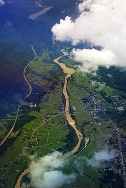
Aerial view of the Waga River with
Ishibane Dam in the center and Yuda Dam and Lake Kinshu visible in the distance
1564:
857:
1574:
1569:
1525:
578:
937:
466:
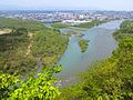
The Waga River (left) empties into the
Kitakami River on the south side of Kitakami City. View from Otoka-yama
608:
772:
1379:
564:
914:
358:. Located at the head of the Geto River is Geto Onsen and Geto Ski Area, both popular attractions.
1369:
1460:
1455:
1285:
1232:
1165:
378:
people whose artifacts can be found in many places. One of the more famous sites is at
Kunenbashi
1374:
415:
in the town of
Nishiwaga. It was completed in 1964 creating a much larger reservoir, Lake Kinshu
1260:
1242:
1100:
535:
508:
479:
130:
115:
1127:
1055:
1030:
844:
739:
691:
322:
310:
1480:
1359:
1295:
919:
767:
657:
326:
205:
1364:
1095:
1080:
997:
929:
669:
318:
178:
1470:
1391:
1354:
1185:
1170:
1035:
899:
874:
869:
787:
777:
729:
724:
719:
711:
701:
652:
642:
445:
330:
217:
1553:
1498:
1450:
1445:
1386:
1300:
1210:
1180:
1147:
1122:
1010:
987:
884:
879:
852:
792:
762:
749:
647:
1493:
1488:
1398:
1349:
1310:
1305:
1290:
1255:
1195:
1175:
1155:
1137:
1110:
1090:
1075:
1050:
1025:
972:
967:
904:
894:
889:
734:
696:
676:
634:
408:
366:
1465:
1275:
1225:
1040:
531:
Ecology of
Riparian Forests in Japan: Disturbance, Life History, and Regeneration
529:
502:
1250:
1070:
1045:
1005:
952:
909:
864:
681:
662:
432:
398:
200:
352:
are located in geologically active areas that provide hot springs for numerous
1440:
1265:
1220:
1215:
1205:
1200:
1190:
1132:
1105:
1085:
1060:
1020:
1015:
982:
977:
957:
947:
782:
757:
246:
233:
1280:
1270:
1160:
1115:
1065:
942:
336:
The headwaters of both the Waga River and its major tributary the Geto River
559:
622:
443:
The Waga River is one of the few places where the endemic willow species
412:
375:
1334:
1422:
832:
401:
fossil beds have also been found in the lower terrace of the river.
603:
365:
354:
314:
1419:
1331:
829:
619:
574:
374:
In prehistoric times the Waga River valley was occupied by the
370:
The Waga River and its tributary Geto River in Iwate
Prefecture
321:
it flows from north to south through the entire length of
1479:
1433:
1241:
1146:
996:
928:
843:
748:
710:
633:
280:
272:
262:
223:
211:
199:
185:
171:
163:
154:
146:
141:
100:
21:
333:on the south side of the city opposite Mt. Otoko.
528:Sakio, Hitoshi; Tamura, Toshikazu (2008-12-22).
424:
387:
345:
302:
418:
381:
339:
296:
122:
107:
586:
8:
317:. From its headwaters near Mt. Waga in the
1430:
1416:
1342:
1328:
840:
826:
630:
616:
593:
579:
571:
431:. On the Geto River construction of the
493:
456:
18:
7:
1532:
804:
504:Encyclopedia of Quaternary Science
478:Lake Kinshu as seen from near the
80:
52:
16:A river in Iwate Prefecture, Japan
14:
609:River systems and rivers of Japan
507:. Elsevier Science. p. 207.
284:952 km (368 sq mi)
1531:
1520:
1519:
803:
602:
558:
471:
459:
79:
72:
51:
44:
27:
225: • coordinates
60:Location of the mouth in Japan
1:
810:Rivers of Hokkaido on Commons
155:Physical characteristics
325:before turning east through
264: • elevation
191:1,200 m (3,900 ft)
187: • elevation
63:Show map of Iwate Prefecture
687:Shiribeshi-Toshibetsu River
425:
388:
346:
303:
276:75.3 km (46.8 mi)
213: • location
173: • location
1591:
1560:Rivers of Iwate Prefecture
1538:Rivers of Japan on Commons
435:lasted from 1974 to 1990.
1515:
1429:
1415:
1345:
1341:
1327:
839:
825:
801:
629:
615:
534:. Springer. p. 283.
501:Mock, Cary (2013-03-25).
419:
382:
340:
297:
195:
159:
123:
108:
38:
26:
1526:Rivers of Japan Category
329:. The River enters the
268:52 m (171 ft)
371:
247:39.27083°N 141.12333°E
369:
567:at Wikimedia Commons
1380:Sumiyoshijima River
252:39.27083; 141.12333
243: /
372:
88:Waga River (Japan)
1547:
1546:
1511:
1510:
1507:
1506:
1411:
1410:
1407:
1406:
1323:
1322:
1319:
1318:
1101:Kiso Three Rivers
821:
820:
817:
816:
563:Media related to
541:978-4-431-76737-4
514:978-0-444-53642-6
288:
287:
91:Show map of Japan
1582:
1565:Nishiwaga, Iwate
1535:
1534:
1523:
1522:
1431:
1417:
1343:
1329:
841:
827:
807:
806:
692:Shiribetsu River
631:
617:
607:
606:
595:
588:
581:
572:
562:
546:
545:
525:
519:
518:
498:
475:
463:
430:
428:
422:
421:
395:
394:
391:
385:
384:
351:
349:
343:
342:
311:Iwate Prefecture
308:
306:
300:
299:
258:
257:
255:
254:
253:
248:
244:
241:
240:
239:
236:
188:
174:
134:
126:
125:
119:
111:
110:
92:
83:
82:
76:
64:
55:
54:
48:
31:
19:
1590:
1589:
1585:
1584:
1583:
1581:
1580:
1579:
1575:Rivers of Japan
1570:Kitakami, Iwate
1550:
1549:
1548:
1543:
1503:
1481:Yaeyama Islands
1475:
1425:
1403:
1360:Shinmachi River
1337:
1315:
1296:Takahashi River
1237:
1142:
992:
924:
920:Yoneshiro River
835:
813:
797:
768:Mitsuishi River
744:
706:
658:Makomanai River
625:
611:
601:
599:
555:
550:
549:
542:
527:
526:
522:
515:
500:
499:
495:
490:
483:
476:
467:
464:
455:
441:
416:
392:
379:
364:
337:
294:
265:
251:
249:
245:
242:
237:
234:
232:
230:
229:
226:
214:
206:Kitakami, Iwate
186:
172:
137:
128:
113:
96:
95:
94:
93:
90:
89:
86:
85:
84:
67:
66:
65:
62:
61:
58:
57:
56:
34:
17:
12:
11:
5:
1588:
1586:
1578:
1577:
1572:
1567:
1562:
1552:
1551:
1545:
1544:
1542:
1541:
1529:
1516:
1513:
1512:
1509:
1508:
1505:
1504:
1502:
1501:
1496:
1491:
1485:
1483:
1477:
1476:
1474:
1473:
1468:
1463:
1458:
1453:
1448:
1443:
1437:
1435:
1427:
1426:
1420:
1413:
1412:
1409:
1408:
1405:
1404:
1402:
1401:
1396:
1395:
1394:
1384:
1383:
1382:
1377:
1372:
1367:
1357:
1355:Shimanto River
1352:
1346:
1339:
1338:
1332:
1325:
1324:
1321:
1320:
1317:
1316:
1314:
1313:
1308:
1303:
1298:
1293:
1288:
1283:
1278:
1273:
1268:
1263:
1261:Gōnokawa River
1258:
1253:
1247:
1245:
1243:Chūgoku region
1239:
1238:
1236:
1235:
1230:
1229:
1228:
1223:
1218:
1213:
1208:
1198:
1193:
1188:
1186:Maruyama River
1183:
1178:
1173:
1171:Kinokawa River
1168:
1163:
1158:
1152:
1150:
1144:
1143:
1141:
1140:
1135:
1130:
1125:
1120:
1119:
1118:
1113:
1108:
1098:
1093:
1088:
1083:
1078:
1073:
1068:
1063:
1058:
1053:
1048:
1043:
1038:
1033:
1028:
1023:
1018:
1013:
1008:
1002:
1000:
994:
993:
991:
990:
985:
980:
975:
970:
965:
960:
955:
950:
945:
940:
934:
932:
926:
925:
923:
922:
917:
912:
907:
902:
897:
892:
887:
882:
877:
875:Komagome River
872:
870:Kitakami River
867:
862:
861:
860:
849:
847:
837:
836:
830:
823:
822:
819:
818:
815:
814:
802:
799:
798:
796:
795:
790:
788:Shizunai River
785:
780:
778:Niikappu River
775:
770:
765:
760:
754:
752:
746:
745:
743:
742:
737:
732:
730:Shokotsu River
727:
725:Shibetsu River
722:
720:Abashiri River
716:
714:
712:Sea of Okhotsk
708:
707:
705:
704:
702:Zenibako River
699:
694:
689:
684:
679:
674:
673:
672:
667:
666:
665:
660:
653:Toyohira River
650:
643:Ishikari River
639:
637:
627:
626:
620:
613:
612:
600:
598:
597:
590:
583:
575:
569:
568:
554:
553:External links
551:
548:
547:
540:
520:
513:
492:
491:
489:
486:
485:
484:
477:
470:
468:
465:
458:
454:
451:
446:Salix hukaoana
440:
437:
363:
360:
331:Kitakami River
323:Nishiwaga Town
309:is a river in
286:
285:
282:
278:
277:
274:
270:
269:
266:
263:
260:
259:
227:
224:
221:
220:
218:Kitakami River
215:
212:
209:
208:
203:
197:
196:
193:
192:
189:
183:
182:
175:
169:
168:
165:
161:
160:
157:
156:
152:
151:
148:
144:
143:
139:
138:
136:
135:
120:
104:
102:
98:
97:
87:
78:
77:
71:
70:
69:
68:
59:
50:
49:
43:
42:
41:
40:
39:
36:
35:
32:
24:
23:
15:
13:
10:
9:
6:
4:
3:
2:
1587:
1576:
1573:
1571:
1568:
1566:
1563:
1561:
1558:
1557:
1555:
1540:
1539:
1530:
1528:
1527:
1518:
1517:
1514:
1500:
1499:Urauchi River
1497:
1495:
1492:
1490:
1487:
1486:
1484:
1482:
1478:
1472:
1469:
1467:
1464:
1462:
1459:
1457:
1454:
1452:
1451:Kikuchi River
1449:
1447:
1446:Chikugo River
1444:
1442:
1439:
1438:
1436:
1432:
1428:
1424:
1418:
1414:
1400:
1397:
1393:
1390:
1389:
1388:
1387:Yoshino River
1385:
1381:
1378:
1376:
1373:
1371:
1368:
1366:
1363:
1362:
1361:
1358:
1356:
1353:
1351:
1348:
1347:
1344:
1340:
1336:
1330:
1326:
1312:
1309:
1307:
1304:
1302:
1301:Takatsu River
1299:
1297:
1294:
1292:
1289:
1287:
1284:
1282:
1279:
1277:
1274:
1272:
1269:
1267:
1264:
1262:
1259:
1257:
1254:
1252:
1249:
1248:
1246:
1244:
1240:
1234:
1231:
1227:
1224:
1222:
1219:
1217:
1214:
1212:
1211:Katsura River
1209:
1207:
1204:
1203:
1202:
1199:
1197:
1194:
1192:
1189:
1187:
1184:
1182:
1181:Kuzuryu River
1179:
1177:
1174:
1172:
1169:
1167:
1164:
1162:
1159:
1157:
1154:
1153:
1151:
1149:
1148:Kansai region
1145:
1139:
1136:
1134:
1131:
1129:
1126:
1124:
1123:Kushida River
1121:
1117:
1114:
1112:
1109:
1107:
1104:
1103:
1102:
1099:
1097:
1094:
1092:
1089:
1087:
1084:
1082:
1079:
1077:
1074:
1072:
1069:
1067:
1064:
1062:
1059:
1057:
1056:Kuzuryū River
1054:
1052:
1049:
1047:
1044:
1042:
1039:
1037:
1034:
1032:
1031:Jōganji River
1029:
1027:
1024:
1022:
1019:
1017:
1014:
1012:
1011:Shinano River
1009:
1007:
1004:
1003:
1001:
999:
995:
989:
988:Tsurumi River
986:
984:
981:
979:
976:
974:
971:
969:
966:
964:
961:
959:
956:
954:
951:
949:
946:
944:
941:
939:
938:Arakawa River
936:
935:
933:
931:
927:
921:
918:
916:
913:
911:
908:
906:
903:
901:
898:
896:
893:
891:
888:
886:
885:Mabechi River
883:
881:
880:Koyoshi River
878:
876:
873:
871:
868:
866:
863:
859:
858:Arakawa River
856:
855:
854:
853:Abukuma River
851:
850:
848:
846:
845:Tōhoku region
842:
838:
834:
828:
824:
812:
811:
800:
794:
793:Tokachi River
791:
789:
786:
784:
781:
779:
776:
774:
771:
769:
766:
764:
763:Kushiro River
761:
759:
756:
755:
753:
751:
750:Pacific Ocean
747:
741:
740:Yūbetsu River
738:
736:
733:
731:
728:
726:
723:
721:
718:
717:
715:
713:
709:
703:
700:
698:
695:
693:
690:
688:
685:
683:
680:
678:
675:
671:
668:
664:
661:
659:
656:
655:
654:
651:
649:
648:Chitose River
646:
645:
644:
641:
640:
638:
636:
632:
628:
624:
618:
614:
610:
605:
596:
591:
589:
584:
582:
577:
576:
573:
566:
561:
557:
556:
552:
543:
537:
533:
532:
524:
521:
516:
510:
506:
505:
497:
494:
487:
482:train station
481:
474:
469:
462:
457:
452:
450:
448:
447:
438:
436:
434:
427:
414:
410:
406:
402:
400:
390:
377:
368:
361:
359:
357:
356:
348:
334:
332:
328:
327:Kitakami City
324:
320:
316:
312:
305:
293:
283:
279:
275:
271:
267:
261:
256:
228:
222:
219:
216:
210:
207:
204:
202:
198:
194:
190:
184:
180:
176:
170:
166:
162:
158:
153:
149:
145:
140:
132:
121:
117:
106:
105:
103:
99:
75:
47:
37:
30:
25:
20:
1536:
1524:
1494:Nakama River
1489:Kokuba River
1399:Niyodo River
1370:Tamiya River
1365:Suketō River
1350:Aibiki River
1311:Yoshii River
1306:Tenjin River
1291:Sendai River
1256:Ashida River
1196:Yamato River
1176:Kumano River
1156:Choshi River
1138:Minami River
1111:Nagara River
1096:Shōnai River
1091:Yahagi River
1081:Tenryū River
1076:Sakawa River
1051:Tedori River
1026:Kurobe River
998:Chūbu region
973:Sumida River
968:Sagami River
930:Kantō region
915:Takase River
905:Oirase River
895:Natori River
890:Mogami River
808:
735:Tokoro River
697:Teshio River
677:Koetoi River
670:Yūbari River
635:Sea of Japan
530:
523:
503:
496:
480:JR Hottoyuda
444:
442:
409:Ishibane Dam
407:
403:
373:
353:
335:
319:Ōu Mountains
291:
289:
179:Ōu Mountains
177:Mount Waga,
1471:Ōyodo River
1392:Dōzan River
1251:Asahi River
1226:Dōton River
1046:Oyabe River
1036:Jinzū River
1006:Agano River
953:Kanda River
910:Omono River
900:Ōhata River
865:Iwaki River
682:Rumoi River
663:Anano River
433:Irihata Dam
399:Pleistocene
250: /
238:141°07′24″E
101:Native name
1554:Categories
1461:Mimi River
1456:Kuma River
1441:Arie River
1421:Rivers of
1375:Sako River
1333:Rivers of
1286:Saba River
1266:Hino River
1233:Yura River
1221:Kizu River
1216:Kamo River
1206:Yasu River
1201:Yodo River
1191:Muko River
1166:Kako River
1133:Kita River
1128:Miya River
1106:Kiso River
1086:Toyo River
1061:Fuji River
1021:Hime River
1016:Seki River
983:Tone River
978:Tama River
963:Naka River
958:Kuji River
948:Fuji River
831:Rivers of
783:Saru River
758:Akan River
621:Rivers of
565:Waga River
488:References
449:is found.
389:Kunenbashi
292:Waga River
281:Basin size
235:39°16′15″N
22:Waga River
1466:Ōno River
1281:Oze River
1276:Ōta River
1271:Hii River
1161:Ibo River
1116:Ibi River
1066:Abe River
1041:Shō River
943:Edo River
426:Kinshū-ko
347:Geto-gawa
304:Waga-gawa
1071:Ōi River
773:Mu River
623:Hokkaido
413:Yuda Dam
142:Location
131:Japanese
116:Japanese
1335:Shikoku
453:Gallery
439:Ecology
362:History
181:, Iwate
147:Country
1434:Kyushu
1423:Kyushu
833:Honshu
538:
511:
273:Length
167:
164:Source
127:
112:
376:Jōmon
355:onsen
315:Japan
201:Mouth
150:Japan
536:ISBN
509:ISBN
290:The
420:錦秋湖
383:九年橋
341:夏油川
298:和賀川
124:和華川
109:和賀川
1556::
423:,
386:,
344:,
313:,
301:,
594:e
587:t
580:v
544:.
517:.
429:)
417:(
393:)
380:(
350:)
338:(
307:)
295:(
133:)
129:(
118:)
114:(
Text is available under the Creative Commons Attribution-ShareAlike License. Additional terms may apply.