97:
434:
559:
78:
22:
104:
495:, is a significant tributary of the Wakefield River. The high rainfall in the Skilly Hills contributes to the Skillogalee Creek being one of the few permanently flowing watercourses in the region.
537:, the promoter of the scheme of systematic colonization that led to the founding of the Colony of South Australia. Hill was embarked upon the expedition which led to his discovery of the
1496:
773:
96:
740:
506:
and only flows during periods of rain. Its headwaters are located in the hills on the western side of the town and it runs along a small gully, passing under
43:
30:
1530:
1489:
766:
311:
1221:
234:
701:
682:
673:
Natural
Heritage Trust (Australia); South Australia. Environment Protection Agency; South Australia. Department for Water Resources (2000),
1525:
1515:
1482:
1278:
759:
1387:
802:
545:, in late May 1839, who records that he encamped "upon a chain of large ponds of excellent water called by Mr. Hill the Wakefield".
1005:
1010:
900:
466:
297:
1535:
1345:
1135:
995:
856:
220:
1288:
1140:
1015:
1000:
895:
822:
476:
covers 1,913 square kilometres (739 sq mi). Three quarters of the catchment is used for agricultural purposes.
1314:
1309:
1079:
969:
817:
812:
480:
433:
1393:
1273:
1263:
839:
574:
498:
Dennis Creek is another tributary of the
Wakefield River. It is a very short ephemeral stream which is located in the
492:
944:
1293:
1283:
1214:
458:
450:
438:
696:
Water
Allocation Plan for the Clare Valley Prescribed Water Resources Area, (Government of South Australia, 2009)
35:
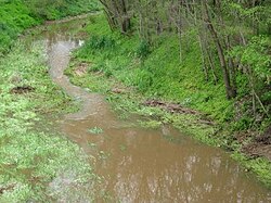
1431:
446:
982:
1520:
1361:
1268:
880:
866:
727:
E.J. Eyre's
Autobiographical Narrative, 1832-1839, edited by Jill Waterhouse (Caliban, London, 1984), page 196.
647:
1366:
1253:
1248:
534:
503:
454:
130:
83:
1258:
564:
1207:
807:
1174:
1145:
530:
1179:
1421:
745:
1084:
922:
917:
907:
849:
697:
678:
484:
397:
1466:
457:, where it is fed by several small creeks, and then curves to flow westerly past the town of
1399:
1371:
1069:
1049:
932:
873:
861:
542:
597:
1462:
1340:
1234:
1184:
1169:
1107:
1074:
1031:
885:
834:
783:
654:. Department of Sustainability, Environment, Water, Population and Communities. 6 May 2009
507:
462:
422:
414:
285:
189:
175:
148:
116:
533:(incorrectly named William Hill by some sources) in early April 1839, who named it after
487:, Pine, Rices, Hermitage and Woolshed Flat Creeks. Skillogalee Creek, which rises in the
619:
77:
1426:
510:, and into the Wakefield River. The creek was named after James Dennis, the father of
473:
1509:
1150:
1130:
1125:
1120:
1094:
1089:
1039:
959:
927:
912:
829:
797:
112:
1441:
1436:
1324:
1230:
1161:
1115:
1064:
1044:
1020:
538:
499:
488:
208:
1199:
1059:
1054:
990:
937:
890:
844:
511:
280:
949:
554:
326:
313:
249:
236:
954:
751:
714:
185:
165:
21:
1405:
418:
432:
1203:
755:
15:
387:
Pine Creek (Wakefield River)|Pine Creek, Woolshed Flat Creek
677:, Environment Protection Agency, pp. 13, 17 & 61,
1470:
479:
The major tributaries of the
Wakefield River are the
748:
Environmental
Protection Authority (South Australia)
1414:
1380:
1354:
1333:
1302:
1241:
1159:
1105:
1029:
980:
790:
675:
A river management plan for the
Wakefield catchment
391:
381:
373:
368:
360:
352:
342:
303:
291:
279:
265:
226:
214:
204:
195:
181:
171:
161:
156:
136:
126:
70:
575:List of rivers of Australia § South Australia
529:The first recorded sighting of the river was from
1490:
1215:
767:
8:
541:. The second European to visit was explorer
140:
642:
640:
1497:
1483:
1222:
1208:
1200:
774:
760:
752:
514:, who ran a hotel in the town for a time.
449:, flowing southward, passing the towns of
46:of all important aspects of the article.
586:
103:
592:
590:
67:
42:Please consider expanding the lead to
7:
1458:
1456:
364:1,913 km (739 sq mi)
65:River in South Australia, Australia
1469:. You can help Knowledge (XXG) by
791:Rivers that flow towards the coast
746:Archived water quality assessments
652:Australian Natural Resources Atlas
600:. State Library of South Australia
14:
1388:Clare and Gilbert Valleys Council
624:Bonzle Digital Atlas of Australia
557:
102:
95:
82:Wakefield River flowing through
76:
20:
1531:South Australia geography stubs
34:may be too short to adequately
1461:This article about a river in
1346:Spring Gully Conservation Park
305: • coordinates
228: • coordinates
44:provide an accessible overview
1:
196:Physical characteristics
620:"Map of Wakefield River, SA"
437:Wakefield River in flood at
344: • elevation
267: • elevation
1526:Mid North (South Australia)
1394:Electoral district of Frome
421:in the Australian state of
293: • location
216: • location
1552:
1455:
271:429 m (1,407 ft)
1516:Rivers of South Australia
1432:Lavender Federation Trail
741:Wakefield River Catchment
648:"Soils - Wakefield River"
403:
275:
200:
90:
75:
1362:Clare Valley wine region
393: • right
356:116 km (72 mi)
1367:Clare Valley Racecourse
535:Edward Gibbon Wakefield
383: • left
141:
131:Edward Gibbon Wakefield
945:Pirie–Torrens corridor
565:South Australia portal
445:The river rises above
442:
327:34.19000°S 138.14389°E
250:33.93583°S 138.86278°E
1536:Australia river stubs
1381:Governance and people
436:
1160:Rivers flowing into
983:Murray–Darling basin
348:0 m (0 ft)
332:-34.19000; 138.14389
255:-33.93583; 138.86278
1415:Walking and cycling
928:Glen Osmond/Keswick
519:Course of the river
429:Course and features
369:Basin features
323: /
246: /
1422:Rattler Rail Trail
1355:Places of interest
598:"Wakefield, River"
443:
1478:
1477:
1450:
1449:
1279:Polish Hill River
1197:
1196:
702:978-0-9806143-1-2
684:978-1-876562-19-9
461:into the head of
417:that flows to an
407:
406:
398:Skillogalee Creek
61:
60:
1543:
1499:
1492:
1485:
1457:
1400:Division of Grey
1372:Horrocks Highway
1303:Rivers and hills
1224:
1217:
1210:
1201:
1175:Calabrinda Creek
776:
769:
762:
753:
728:
725:
719:
718:
711:
705:
694:
688:
687:
670:
664:
663:
661:
659:
644:
635:
634:
632:
630:
616:
610:
609:
607:
605:
594:
567:
562:
561:
560:
543:Edward John Eyre
394:
384:
338:
337:
335:
334:
333:
328:
324:
321:
320:
319:
316:
268:
261:
260:
258:
257:
256:
251:
247:
244:
243:
242:
239:
229:
217:
152:
144:
111:Location of the
106:
105:
99:
80:
68:
56:
53:
47:
24:
16:
1551:
1550:
1546:
1545:
1544:
1542:
1541:
1540:
1521:Adelaide Plains
1506:
1505:
1504:
1503:
1463:South Australia
1453:
1451:
1446:
1410:
1376:
1350:
1341:Martindale Hall
1334:Protected areas
1329:
1320:Wakefield River
1298:
1237:
1235:South Australia
1228:
1198:
1193:
1185:Wirreanda Creek
1170:Willochra Creek
1155:
1108:Kangaroo Island
1101:
1032:Lake Eyre basin
1025:
976:
786:
784:South Australia
780:
737:
732:
731:
726:
722:
713:
712:
708:
695:
691:
685:
672:
671:
667:
657:
655:
646:
645:
638:
628:
626:
618:
617:
613:
603:
601:
596:
595:
588:
583:
571:
570:
563:
558:
556:
551:
527:
522:
521:
520:
508:Main North Road
463:Gulf St Vincent
431:
423:South Australia
415:ephemeral river
411:Wakefield River
392:
382:
345:
331:
329:
325:
322:
317:
314:
312:
310:
309:
306:
294:
286:Gulf St Vincent
266:
254:
252:
248:
245:
240:
237:
235:
233:
232:
227:
215:
190:Adelaide Plains
176:South Australia
146:
122:
121:
120:
119:
117:South Australia
109:
108:
107:
86:
66:
57:
51:
48:
41:
29:This article's
25:
12:
11:
5:
1549:
1547:
1539:
1538:
1533:
1528:
1523:
1518:
1508:
1507:
1502:
1501:
1494:
1487:
1479:
1476:
1475:
1448:
1447:
1445:
1444:
1439:
1434:
1429:
1427:Riesling Trail
1424:
1418:
1416:
1412:
1411:
1409:
1408:
1403:
1402:(Commonwealth)
1397:
1391:
1384:
1382:
1378:
1377:
1375:
1374:
1369:
1364:
1358:
1356:
1352:
1351:
1349:
1348:
1343:
1337:
1335:
1331:
1330:
1328:
1327:
1322:
1317:
1312:
1306:
1304:
1300:
1299:
1297:
1296:
1291:
1286:
1281:
1276:
1271:
1266:
1261:
1256:
1251:
1245:
1243:
1239:
1238:
1229:
1227:
1226:
1219:
1212:
1204:
1195:
1194:
1192:
1191:
1190:
1189:
1188:
1187:
1177:
1166:
1164:
1157:
1156:
1154:
1153:
1148:
1146:Stun Sail Boom
1143:
1138:
1133:
1128:
1123:
1118:
1112:
1110:
1103:
1102:
1100:
1099:
1098:
1097:
1092:
1087:
1082:
1072:
1067:
1062:
1057:
1052:
1047:
1042:
1036:
1034:
1030:Rivers of the
1027:
1026:
1024:
1023:
1018:
1013:
1008:
1003:
998:
993:
987:
985:
981:Rivers of the
978:
977:
975:
974:
973:
972:
962:
957:
952:
947:
942:
941:
940:
935:
930:
920:
915:
910:
905:
904:
903:
893:
888:
883:
878:
877:
876:
871:
870:
869:
854:
853:
852:
842:
837:
832:
827:
826:
825:
820:
815:
810:
800:
794:
792:
788:
787:
781:
779:
778:
771:
764:
756:
750:
749:
743:
736:
735:External links
733:
730:
729:
720:
706:
689:
683:
665:
636:
611:
585:
584:
582:
579:
578:
577:
569:
568:
553:
552:
550:
547:
526:
523:
518:
517:
516:
474:catchment area
467:Port Wakefield
430:
427:
405:
404:
401:
400:
395:
389:
388:
385:
379:
378:
375:
371:
370:
366:
365:
362:
358:
357:
354:
350:
349:
346:
343:
340:
339:
307:
304:
301:
300:
298:Port Wakefield
295:
292:
289:
288:
283:
277:
276:
273:
272:
269:
263:
262:
230:
224:
223:
218:
212:
211:
206:
202:
201:
198:
197:
193:
192:
183:
179:
178:
173:
169:
168:
163:
159:
158:
154:
153:
138:
134:
133:
128:
124:
123:
110:
101:
100:
94:
93:
92:
91:
88:
87:
81:
73:
72:
64:
59:
58:
38:the key points
28:
26:
19:
13:
10:
9:
6:
4:
3:
2:
1548:
1537:
1534:
1532:
1529:
1527:
1524:
1522:
1519:
1517:
1514:
1513:
1511:
1500:
1495:
1493:
1488:
1486:
1481:
1480:
1474:
1472:
1468:
1464:
1459:
1454:
1443:
1440:
1438:
1435:
1433:
1430:
1428:
1425:
1423:
1420:
1419:
1417:
1413:
1407:
1404:
1401:
1398:
1395:
1392:
1389:
1386:
1385:
1383:
1379:
1373:
1370:
1368:
1365:
1363:
1360:
1359:
1357:
1353:
1347:
1344:
1342:
1339:
1338:
1336:
1332:
1326:
1323:
1321:
1318:
1316:
1313:
1311:
1308:
1307:
1305:
1301:
1295:
1292:
1290:
1287:
1285:
1282:
1280:
1277:
1275:
1272:
1270:
1267:
1265:
1262:
1260:
1257:
1255:
1252:
1250:
1247:
1246:
1244:
1240:
1236:
1232:
1225:
1220:
1218:
1213:
1211:
1206:
1205:
1202:
1186:
1183:
1182:
1181:
1180:Kanyaka Creek
1178:
1176:
1173:
1172:
1171:
1168:
1167:
1165:
1163:
1158:
1152:
1149:
1147:
1144:
1142:
1139:
1137:
1134:
1132:
1129:
1127:
1124:
1122:
1119:
1117:
1114:
1113:
1111:
1109:
1104:
1096:
1093:
1091:
1088:
1086:
1083:
1081:
1078:
1077:
1076:
1073:
1071:
1068:
1066:
1063:
1061:
1058:
1056:
1053:
1051:
1048:
1046:
1043:
1041:
1038:
1037:
1035:
1033:
1028:
1022:
1019:
1017:
1014:
1012:
1009:
1007:
1004:
1002:
999:
997:
994:
992:
989:
988:
986:
984:
979:
971:
968:
967:
966:
963:
961:
958:
956:
953:
951:
948:
946:
943:
939:
936:
934:
931:
929:
926:
925:
924:
921:
919:
916:
914:
911:
909:
906:
902:
899:
898:
897:
894:
892:
889:
887:
884:
882:
879:
875:
872:
868:
865:
864:
863:
860:
859:
858:
855:
851:
848:
847:
846:
843:
841:
838:
836:
833:
831:
828:
824:
821:
819:
816:
814:
811:
809:
806:
805:
804:
801:
799:
796:
795:
793:
789:
785:
777:
772:
770:
765:
763:
758:
757:
754:
747:
744:
742:
739:
738:
734:
724:
721:
716:
710:
707:
703:
699:
693:
690:
686:
680:
676:
669:
666:
653:
649:
643:
641:
637:
625:
621:
615:
612:
599:
593:
591:
587:
580:
576:
573:
572:
566:
555:
548:
546:
544:
540:
536:
532:
524:
515:
513:
509:
505:
501:
496:
494:
490:
486:
482:
477:
475:
470:
468:
464:
460:
456:
452:
448:
440:
435:
428:
426:
424:
420:
416:
412:
402:
399:
396:
390:
386:
380:
376:
372:
367:
363:
359:
355:
351:
347:
341:
336:
308:
302:
299:
296:
290:
287:
284:
282:
278:
274:
270:
264:
259:
231:
225:
222:
221:Black Springs
219:
213:
210:
207:
203:
199:
194:
191:
187:
184:
180:
177:
174:
170:
167:
164:
160:
155:
150:
143:
139:
135:
132:
129:
125:
118:
114:
98:
89:
85:
79:
74:
69:
63:
55:
45:
39:
37:
32:
27:
23:
18:
17:
1471:expanding it
1460:
1452:
1442:Heysen Trail
1437:Mawson Trail
1325:Skilly Hills
1319:
1289:Stanley Flat
1231:Clare Valley
1162:Lake Torrens
964:
723:
709:
692:
674:
668:
656:. Retrieved
651:
627:. Retrieved
623:
614:
602:. Retrieved
539:Clare Valley
528:
500:Clare Valley
497:
489:Skilly Hills
478:
472:The river's
471:
444:
410:
408:
209:Clare Valley
62:
49:
33:
31:lead section
1085:Kallakoopah
923:Patawalonga
918:Onkaparinga
908:Little Para
850:Panalatinga
512:C.J. Dennis
485:Skillogalee
374:Tributaries
330: /
318:138°08′38″E
253: /
241:138°51′46″E
137:Native name
113:river mouth
1510:Categories
1315:Hutt River
1310:Hill River
1274:Penwortham
1264:Leasingham
1242:Main towns
1106:Rivers of
1070:Strzelecki
1050:Diamantina
933:Brown Hill
874:South Para
862:North Para
782:Rivers of
658:25 October
581:References
493:Penwortham
361:Basin size
315:34°11′24″S
52:March 2022
1294:Watervale
1284:Sevenhill
1075:Warburton
965:Wakefield
886:Hindmarsh
835:Christies
803:Broughton
531:John Hill
459:Balaklava
451:Watervale
439:Whitwarta
238:33°56′9″S
186:Mid North
166:Australia
127:Etymology
71:Wakefield
36:summarize
1406:Ngadjuri
1006:Currency
629:25 March
549:See also
502:town of
447:Merildin
157:Location
1396:(state)
1390:(local)
1269:Mintaro
1151:Willson
1131:Harriet
1126:Eleanor
1121:De Mole
1095:Macumba
1090:Officer
1040:Alberga
1011:Finniss
960:Torrens
913:Myponga
901:Gilbert
881:Glenelg
830:Bungala
808:Crystal
798:Acraman
715:"Trove"
604:29 July
525:History
441:in 2010
419:estuary
162:Country
142:Undalya
1254:Auburn
1249:Armagh
1136:Middle
1116:Cygnet
1065:Neales
1045:Cooper
1021:Murray
996:Bremer
867:Jacobs
857:Gawler
700:
681:
504:Auburn
455:Auburn
413:is an
377:
353:Length
205:Source
182:Region
149:Kaurna
145:
84:Auburn
1465:is a
1259:Clare
1141:Rocky
1060:Frome
1055:Finke
1016:Marne
1001:Burra
991:Angas
938:Sturt
896:Light
891:Inman
845:Field
823:Rocky
491:near
281:Mouth
172:State
1467:stub
1080:Eyre
970:Eyre
950:Port
818:Hutt
813:Hill
698:ISBN
679:ISBN
660:2011
631:2017
606:2015
481:Eyre
453:and
409:The
955:Tod
840:Dry
465:at
115:in
1512::
1233:,
650:.
639:^
622:.
589:^
483:,
469:.
425:.
188:,
1498:e
1491:t
1484:v
1473:.
1223:e
1216:t
1209:v
775:e
768:t
761:v
717:.
704:.
662:.
633:.
608:.
151:)
147:(
54:)
50:(
40:.
Text is available under the Creative Commons Attribution-ShareAlike License. Additional terms may apply.